Kola Peninsula: history, description and interesting facts. Travel to the Kola Peninsula Where is the Kola Peninsula
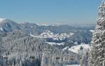
The kingdom of the Russian North, the Kola Peninsula is one of the most pristine, picturesque and harsh regions of Russia. The land washed by the Barents and White Seas is a real natural reserve: it contains more than a third of all the minerals of the planet, mountains and plateaus give way to tundras and lakes, about 100 species of fish live in reservoirs, and the change of day and night obeys the laws of polar latitudes, giving tourists the spectacle of the northern lights . In winter, mainly ski lovers come to the Kola Peninsula: there are several “snow” resorts on the slopes of the Khibiny. And in the warm season, here you can raft along mountain rivers, relax on amazingly clean icy lakes, hike along the Khibiny passes, hunt, fish and get acquainted with the original culture of the Sami peoples.
The main cities of the Kola Peninsula: the capital and largest port of the Russian Arctic - Murmansk, the base of the Northern Fleet - Severomorsk, the gate to the Khibiny - Apatity and Kirovsk.
How to get to the Kola Peninsula
From Moscow and St. Petersburg, the most convenient way to arrive on the Kola Peninsula is by landing at Murmansk Airport. At least 5 flights depart daily from three Moscow airports to Murmansk; The route is served by UTair, Aeroflot, Nordavia, and S7 airlines. Travel time is 2.5 hours. There are even more flights from the northern capital - up to 10 per day. St. Petersburg residents will spend less than 2 hours on the road. The carriers are the same, plus Rossiya Airlines.
In winter, there are direct flights to Apatity, on which skiers arrive on the slopes of the Khibiny.
Lovers of adventure and beautiful scenery can reach the Kola Peninsula by train, also arriving in Murmansk. Muscovites will have to spend at least 30 hours on the road (ticket price from 3,200 RUB), St. Petersburg residents - about 25 hours (from 3,000 RUB). Prices on the page are as of November 2018.
By car, residents of both Russian capitals reach the capital of the peninsula along the M18 federal highway.
The main thing that attracts tourists to the Kola Peninsula is the incredibly beautiful, harsh and solemn nature, practically untouched by man.
A little geography
The Kola Peninsula is a battlefield of primeval nature, pushing, grinding and piling up tectonic plates. Therefore, the landscape here is remarkably diverse: the Khibiny mountain ranges, rising to 1200 m, and high-mountain plateaus covered with coniferous forests, the Lovozero tundra with unique circuses - glacial bowls several kilometers long and up to 200 m high, depressions and lowlands, rivers, lakes, swamps, tundra and taiga... It contains more than a thousand varieties of minerals - a third of all known on the planet, of which 150 are not found anywhere else on Earth.
Russia's border with Finland and Norway runs along the Kola Peninsula, thanks to which there are three international vehicle checkpoints. So, if you have a Schengen visa, you can easily go to our closest northern neighbors for a few days.
Weather on the Kola Peninsula
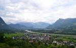
The cold breath of the north leaves its mark on the climate of the Kola Peninsula throughout the year: weather conditions change as if by magic: morning frosts are possible in summer, and prolonged snowstorms in winter. However, the warm current of the North Atlantic has rewarded the north-west of the peninsula with a moderately mild subarctic maritime climate: in particular, in Murmansk and Severomorsk the average January temperature is only −8 °C. In Apatity and Kirovsk it is noticeably colder in winter - up to −15 °C, and on the slopes of Khibiny there is “working” ski snow until May.
Polar days and nights, as well as the northern lights, are the main spectacular features of the peninsula. You can admire the sun not setting over the horizon in June-July, and plunge into the darkness of the night in December-January (then it is worth hunting for the aurora).
Popular hotels in the Kola Peninsula
Entertainment and attractions
The main thing that attracts tourists to the Kola Peninsula (among whom the majority are foreigners) is the incredibly beautiful, harsh and solemn nature, practically untouched by man. Among all the natural heritage, the Khibiny Mountains are a favorite: in winter people come here to ski, in summer they go hiking, rafting down mountain rivers and relaxing at lake resorts. In addition, in Khibiny you should definitely go on an excursion to mining enterprises and visit the Apatite museum and exhibition center in Kirovsk with an interesting exhibition telling about mining.
The Tersky Coast and the Kuzomensky Sands are two amazing natural areas of the peninsula. The first is unanimously recognized as the most picturesque: the deserted coast of the White Sea is strewn with sparkling treasures - rock fragments, including real amethysts.
Kuzomenskie Sands is a mini-desert in northern latitudes: dunes of multi-colored sand stretch for almost 13 km along the sea coast.
The largest and most picturesque lakes of the Kola Peninsula are Imandra, Lovozero and Umbozero. Imandra is ideal for a relaxed, no-frills holiday surrounded by stunningly diverse nature: pebble beaches give way to sharp rocks, sandbanks alternate with piles of boulders. Fishing and hiking through forests and valleys are the most popular leisure activities. Lovozero, with an area of almost 200 km, is surrounded by low mountains under the unobvious name of the Lovozero tundra. Seasonal camp sites operate on the lake, and ascents are organized in the tundra.
Umbozero is the deepest on the peninsula: its depth reaches 100 m. It is notable not only for its picturesque shores, but also for several islands where you can feel like 100% Robinson.
Teriberka is a recent cinematic star of the Kola Peninsula. After the release of the film “Leviathan,” the village, forgotten by God and people, received a rebirth: people come here for specific impressions of the abandonment and ruin of a once prosperous settlement. In Teriberka, you can stand on the coast of the Barents Sea, see the skeletons of ships and the remains of military batteries, wander along deserted beaches strewn with boulders, and look into houses abandoned by residents.
The most interesting nature reserves of the peninsula are Lapland, Kandalaksha and Russian-Norwegian Pasvik. The first is home to relict forests up to 10 thousand years old with 400-600-year-old trees, reindeer, moose, bears, wolves and many other animals. On the shore of Lake Chuna there is another residence of Father Frost - this time Lapland. The Kandalaksha Nature Reserve borders the tundra and northern taiga, where 67 species of mammals and 250 species of birds live. And in Pasvik, tourists can admire pine forests and glacial lakes and see numerous waterfowl.
In the Murmansk region. It is washed by the Barents and White Seas. Almost the entire territory is located beyond the Arctic Circle.
The Kola Peninsula occupies just under 70% of the area of the Murmansk region.
The Sami are the indigenous inhabitants of the Kola Peninsula
The indigenous people who have lived on the Kola Peninsula for a long time are the Sami. The Scandinavians called this small Finno-Ugric people lappar or lapper, the Russians - “Lapps”, “Loplyans” or “Lop”, from this name comes the name Lapland (Lapponia, Lapponica), that is, “land of the Lapps”.
Lapland has never been a single state entity. Currently it is divided between four countries: Sweden, Norway, Finland and Russia (Kola Peninsula).
The total number of Sami is from 60 to 80 thousand; only two thousand people live in Russia (mainly in the Murmansk region), and the number of Sami in Russia has remained almost unchanged over the past hundred years.
The status of the Sami as an indigenous people is enshrined in the Charter of the Murmansk Region; in the village of Lovozero (the center of the cultural life of the Russian Sami), the Sami National Cultural Center operates, various Sami holidays and festivals are held, the Kola Sami Radio broadcasts, and the Museum of the History, Culture and Life of the Kola Sami operates.
In the north of the Kola Peninsula there is tundra vegetation, to the south there is forest-tundra and taiga. In the western part there are the Khibiny mountain ranges (height up to 1200 m) and the Lovozero tundra (height up to 1120 m).
The Khibiny Mountains are the largest mountain range on the Kola Peninsula. The slopes are steep with isolated snowfields, the peaks are plateau-shaped. There are 4 small glaciers with a total area of 0.1 km². Geological age is about 390 million years. In the center are the Kukisvumchorr and Chasnachorr plateaus. The highest point is Mount Yudychvumchorr (1200.6 m above sea level).
The Khibiny mountains were a mysterious region where no human had ever set foot. The only inhabitants of the mountains, animals, roamed freely along the wild slopes and dense forests. And only in the twentieth century did the development of this deserted region begin.

In 1916, a railway was built connecting the Khibiny region with St. Petersburg
In 1920, members of the USSR Academy of Sciences discovered hitherto unknown mineral substances in the foothills of the Khibiny Mountains. The discovery was accidental and in 1921 active development of apatite ore began. A year later, the so-called “Apatite Arc” was discovered, running through the Apatite Circus and the Kukisvumchorr, Rasvumchorr and Poachvumchorr mountains. At first, apatite deposits were not given due importance, but in 1923, geologists seriously thought about the benefits of mining the mineral. In 1929, the Apatite trust was created to mine apatite in the Khibiny Mountains.

Despite its modest size, the Khibiny Mountains are the highest mountains in the Russian Arctic. At the foot are the cities of Apatity and Kirovsk. At the foot of Mount Vudyavrchorr is the Polar-Alpine Botanical Garden-Institute.

Khibiny is also a ski resort, which is now experiencing rapid development.

Lovozero tundra

Lovozero tundra (Lovozero mountain range, Lovozerye) is a mountain range on the Kola Peninsula, located between Lovozero and Umbozero, east of the Khibiny. The area of Lovozerye is almost a thousand square kilometers. The peaks are flat, rocky, up to 1120 meters high on Mount Angwundaschorr. Strictly speaking, these are not mountains, but a high plateau, raised above the ground to a height of about 1 thousand meters, in the shape of a huge horseshoe, the ends of which face Lovozero, and the slopes of the western back side break off towards Umbozero.

These mountains have an average height of eight hundred and fifty meters. Composed of nepheline syenites. Their characteristic feature is the absence of clearly defined peaks. The mountains have rather flat tops, but the slopes are steep, steep, covered in the lower part with coniferous forests. There is no forest vegetation on the peaks.

The ridge reaches its greatest height in the west. The peak of Angvundaschorrd is located there. The eastern part of the massif is occupied by low hills up to four hundred meters high.

In the center of the Lovozero tundra lies the mystical Seydozero. Towards this lake, the mountain slopes drop off with sheer walls. And in the north-west, Seydozero is bordered by a steep cliff, on which the silhouette of Kuyva is “depicted” - according to Sami legends, this is the leader of the invaders, who was nailed to the rock by the chief shaman of the Sami, and his spirit infused into the stone. The Sami avoid this place, and tourists are not advised to take photographs here. caution against taking photographs here. Seydozero, together with the adjacent slopes and gorges of the mountains, is part of the Seydyavr reserve.

On the territory of the reserve there are the Raslaka cirques - two geological formations that are round bowls of glacial origin with a diameter of several kilometers with walls up to 250 meters high.

In the area of the mountain range there is the Lovozero deposit of rare earth metals, which has large reserves of niobium, cesium, tantalum, cerium and other metals, as well as zirconium raw materials (eudialyte). Numerous deposits of rare, sometimes unique, collectible minerals have been discovered within the massif.

The Sami, who have lived here for a long time, call the Lovozero tundra briefly: Luyavrurt. The name is formed from the Sami words “lu” - “yavr” - “urt”, which mean: “stormy” - “lake” - “mountain”, and is translated as “mountain by a stormy lake”. The massif received the name “tundra” because the rocky hills that rose above the forest were called tundra by the Sami who inhabited these places.
Since ancient times, the Sami considered the mountain range a “place of power”, i.e. a place where there are energy fields that are significant for people, and shamans believed that here was a transition to other worlds.
Raslak's circuses, due to their unusual appearance, have also been the subject of Sami tales and legends since ancient times, among them the legend that these are the remains of temples built many centuries ago by giants.

The Lovozero tundra massif is known for various anomalous phenomena, so various expeditions have been sent here many times.
In 1917-1918, Nicholas Roerich visited Luyavrurt, as evidenced by his diaries, which are kept in the library of the University of Lapland. In his diaries, Roerich talks about finding a walled-up entrance with a lock in the shape of a lotus flower.

In 1922, the special encryption department of the Cheka sent a unique expedition to the Luyavrurt area under the leadership of Alexander Vasilevich Barchenko. The official topic of the expedition was an environmental survey of the area adjacent to the Lovozero churchyard. However, the real purpose of the expedition was to search for traces of ancient civilizations.
The expedition found the entrance to some cave, which was photographed. Perhaps after this the entrance was either covered up or disguised - subsequent expeditions have not yet been able to find it. All members of the expedition were destroyed, and the materials were classified, and continue to remain so. Although some information did leak out from the surviving relatives of the expedition members, and this information is one of the reasons for the growing interest in Luyavrurt.
A new phase of legends began in the second half of the 20th century, when, in the wake of the fascination with ufology, the opinion arose that the circuses of Raslak could be landing pads for alien spaceships.
In the 20th century, geologists, biologists and geophysicists came to the conclusion that Luyavrurt is a hyobiogenic zone, i.e. such an area where various forms of life can arise.
Northern Fleet Headquarters
The Russian Northern Fleet bases Severomorsk and Gremikha are located on the Kola Peninsula. Severomorsk is the headquarters of the Northern Fleet.
Photos of the Kola Peninsula


Lavozero tundra photo


GENERAL CHARACTERISTICS OF THE KOLA PENINSULA
The Kola Peninsula is located in the extreme north-west of the European part of Russia and makes up most of the Murmansk region (this section provides only the most necessary general information about the Kola Peninsula for tourists, since extensive literature is devoted to its natural conditions, population, economy and history).
RELIEF OF THE KOLA PENINSULA
The Kola Peninsula is located on the northeastern tip of the Baltic crystalline shield, composed mainly of ancient crystalline igneous rocks: granites, gneisses, diabases. The main features of the relief of the Kola Peninsula are caused by numerous faults and cracks in the crystalline shield. The relief of the peninsula also bears traces of the powerful influence of glaciers, which smoothed the mountain tops and left a large number of boulders and moraine deposits. Based on the nature of the relief, the Murmansk region can be divided into two regions: Western and Eastern. It is generally accepted that the border of these areas runs through the valley of the Voronya River, Lovozero, Umbozero and the valley of the Umba River. The relief of the Western part is more complex than the Eastern one. A deep meridional depression passes through the Western part, occupied by the valleys of the Kola and Niva rivers and Lake Imandra. In the north of the Western region, a high plateau (up to 250 m) drops steeply towards the Barents Sea, forming rocky shores up to 100 m high, indented by bays - fiords. To the southwest of the Murmansk coastal plateau lies the wide Tulomo-Notozero depression, in which the basins of the Lotta, Tuloma and Notozero rivers are located. South of the Tulomo-Notozero depression is the Central Mountain Region, located between the state border of Russia and Lovozero. River valleys and lakes divide this ridge into separate massifs - tundras (on the Kola Peninsula, tundras are called not only the vast treeless spaces of the tundra belt zone, but also treeless mountain ranges). Here, the Roslin, Tuadash, Salnye, Chuna, Monche, Volchi, Khibiny and Lovozero tundras stand out for their height.

To the south of the mountainous region lies the Southern Lake Lowland, extending from the border with Finland to the middle reaches of the Umba. This spacious lowland is occupied by extensive swamps and numerous lakes. There are also hills up to 500 m high. In the north-west, the lowland is limited by the tundras - Korva, Vuva, Liva, Zayachya and Nyavka, in the south-west - by the heights of Rikolatva and Kelesuaive. From the southwest, the lowland is closed by the Kandalaksha (600 m) and Kolvitsky (780 m) mountains, adjacent to the Kandalaksha beret and steeply descending to the White Sea. A significant part of the lowland is occupied by the Pirenga River basin, consisting of lakes connected by short channels (lakes and rivers Ena, Kokh, Kalozhnoe, Chalma, Upper and Lower Pirenga lakes).

The eastern region of the Kola Peninsula according to its relief can be divided into three parts: northern, central and southern. The northern part is a plateau that drops steeply to the Barents Sea and the throat of the White Sea. The plateau is crossed by many gorges and transverse cracks, through which the rivers Kharlovka, Iokanga, Vostochnaya Litsa, and Ponoy flow. To the south, the plateau gradually rises to 300 m and drops sharply to the central swampy lowland. This edge of the plateau is called the Keiva ridge. South of Keiva in the central part of the eastern region is the Central Swamp Plain, which occupies the upper and middle reaches of the Ponoi and the upper reaches of the Varzuga and Strelna. The southern part is a plain, a plane tree, and in some places in the form of terraces, falling to the shores of the White Sea. On the plain there are the basins of the lower reaches of the Varzuga, Strelna, Chapoma, and Chavanga.
VEGETATION OF THE KOLA PENINSULA
There are three vegetation zones on the Kola Peninsula: tundra, forest-tundra and forest. The tundra zone occupies a coastal strip 30–60 km wide in the north and northeast of the peninsula. The main vegetation here is mosses, lichens, creeping varieties of dwarf birch and willow. Woody shrubs are found along the valleys of large rivers. The forest-tundra zone stretches from 10 to 60 km south of the tundra. The characteristic vegetation is a crooked birch forest mixed with spruce and low-growing pine. Various types of shrubs and mosses are found in abundance. In relatively dry places, the soil and stones are covered with a thick layer of moss. In the forest-tundra there are extensive berry fields (lingonberries, cloudberries, blueberries, crowberries) and a lot of mushrooms (boletus, aspen, boletus, russula).

The entire southern part of the peninsula belongs to the forest zone. There are pine and spruce forests with an admixture of birch, aspen, rowan, willow, and alder. The Kola forests are heavily swamped, so shrubs and herbaceous moss vegetation are widespread in them. The southwest of the Murmansk region and the basins of Umba, Varzuga, and Strelna are especially forested. In mountainous areas, vertical zonation of vegetation cover is observed. Up to a height of 300–400 m there is forest vegetation, heights of 400–600 m are occupied by birch forests and shrubs, and above 600–650 m only rare shrubs and lichens grow.
WILDLIFE OF THE KOLA PENINSULA
The fauna of the Kola Peninsula is diverse. Taiga and tundra animals are found here: bear, wolf, hare, marten, fox, squirrel, elk, reindeer, wolverine, arctic fox, pied lemming. In recent years, muskrat and mink have been acclimatized, and beavers have been released. In the waters of the White and Barents Seas live seals, seals, bearded seals and other marine animals. There are about 200 bird species on the peninsula. There are a lot of seabirds: gulls, guillemots, guillemots, puffins. There are large bird colonies on the northern coast. The tundra and tundra partridges live in the tundra, and the hazel grouse, wood grouse, and black grouse live in the forests. 10 species of ducks, geese, and swans nest on the lakes. The Kola Peninsula is an area where there are a lot of mosquitoes, midges and gadflies. The seas washing the peninsula, the lakes and rivers of the Kola Peninsula are rich in fish.

There are more than 110 species of fish in the Barents Sea, of which 22 are commercial (cod, haddock, sea bass, pollock, herring, flounder, etc.). In the sea there are sharks, dolphins and even whales, in rivers and lakes there are pike, perch, grayling, whitefish, char, and vendace. Especially valuable is salmon, which has long been fished on the peninsula; trout are found in large lakes. There are two nature reserves on the Kola Peninsula: Kandalaksha and Lapland. They preserve intact samples of the nature of the North, and create conditions for preserving and increasing the number of rare animals and birds. The Kandalaksha Nature Reserve occupies a significant part of the Kandalaksha skerries, Velikiy Island and the Kem-Ludsky archipelago in the Kandalaksha Bay of the White Sea. The reserve also includes the Seven Islands and Ainov Islands archipelago in the Barents Sea. The territory of the reserve includes corners of the North that are diverse in natural conditions and wildlife, where there is northern taiga, tundra, forest-tundra crooked forests, rocky and sandy shores of islands, high cliffs of the sea coast with huge bird colonies.

The reserve was founded in 1939. One of its main objectives was to study, preserve and increase the number of eiders, the most valuable northern bird. Currently, on the islands of the Kandalaksha Skerries (the reserve includes about 50 islands) there are over 3,000 eider nesting sites. The Lapland Nature Reserve, located west of Monchegorsk, preserves the natural complexes of the northern taiga and mountain tundra of the Kola Peninsula. All characteristic Kola landscapes are represented here, with the exception of the sea coast and flat tundra. One of the main objectives of the reserve is the protection and study of wild reindeer. In 1960, there were about 1,400 deer in the reserve.
CLIMATE OF THE KOLA PENINSULA
The climate of the Kola Peninsula differs significantly from the climate of other northern and polar regions of our country. The North Cape branch of the Gulf Stream, invading from the north-west, brings with it heat, making the northern coast of the peninsula warmer in winter than in the central zone of the European part of Russia. We can say that on the Kola Peninsula, north and south have changed places: the Barents Sea, which washes the northern shores, does not freeze all year round, and in the south of the White Sea peninsula, it is frozen in winter. Within the Kola Peninsula, three climatic zones can be distinguished: the sea coast, the central region and the mountainous part . The climate of the northern sea coast is influenced by the Barents Sea. The average air temperature of the coldest month (February) ranges from -6-12°C, the warmest month (July) is +12-13°C. In the regions of the central part the climate is continental, with relatively warm summers and stable winters. From the coast to the interior of the continent, average annual temperatures decrease. The most continental climate points are Ena and Krasnoshchelye. The average January temperature in Yena is -14.3°C, in Krasnoshchelye -13.7°C. Particularly low temperatures are observed in the upper reaches of the Ponoi River (down to -50°C). The mountainous climatic region has colder summers, relatively mild winters, and a lot of precipitation. The maximum average monthly temperature (July) is +10°C, the minimum (January) is -13°C.

The temperature on Kola is subject to frequent changes: thaws are possible in any winter months, and frosts are possible in summer. This is explained by the fact that over the peninsula, cold air masses coming from the northeast collide with warm air currents. The Kola Peninsula belongs to areas with excess humidity (about 80%). The least amount of precipitation falls in the north (up to 400 mm), the highest in mountainous areas (up to 1000 mm). Most of the peninsula lies north of the Arctic Circle, so the sun does not set here in the summer for one and a half months, and in the winter there is polar night for the same amount of time. Spring is quite late. The snow melts at the end of May - beginning of June, at the same time the lakes open up. Summer comes stormy and quickly, as its beginning coincides with the establishment of the polar day. At the end of June, flowers bloom, young foliage appears on the trees, and night frosts stop (sometimes there are several cold nights during the summer). In mountainous areas, spring and summer are delayed for some time: when all the trees in the lowlands are green, the buds are just swelling there. The polar summer lasts 2.5–3 months: from mid-June to late August–early September. During this short time, the diverse and rich vegetation cover of the mountains and plains of the Kola Peninsula comes to life. Sudden weather changes are possible in summer. The weather is especially changeable in the mountains, where rain and fog are frequent. Most precipitation in the mountains falls in the summer.

Autumn begins at the end of August - beginning of September. In the last week of August, many trees turn yellow, and night frosts become more common. At this time, mosquitoes and midges disappear, especially numerous in July and early August. Snow falls at the end of September, and in the mountains even earlier. However, stable snow cover occurs only in the first ten days of November. The air temperature drops quickly at the end of September. In September, sometimes in August, you can already observe the northern lights—one of the most amazing and beautiful natural phenomena. Rivers freeze in the middle or end of November, and small lakes are covered with ice a little earlier. Only in areas with rapids does freeze-up lag by 1.5-2 months, and powerful rapids do not freeze all winter. The thickness of ice on rivers and lakes ranges from 70 to 110 cm. Snow cover is uneven and depends mainly on the terrain and the prevailing winds in the area.

November is already a winter month, when severe frosts are possible. The day is significantly shortened; throughout December and early January the sun does not appear over the horizon. In March and April, the days lengthen, the weather becomes quite stable, the snow becomes covered with a strong crust, the air temperature, especially in the mountains, rises (in the Khibiny, for example, the average temperature in March is -9°C, in April -2°C). In the evening and at night, however, a significant drop in temperature is possible (down to -30°C and below).
The Kola Peninsula is a tasty morsel for tourists. Its main asset is the Khibiny mountain range, rapids rivers and pristine nature. These places are famous for excellent fishing. In winter, skiers come here. The peninsula is very large - it occupies 70% of the Murmansk region.
In the Far North
The Kola Peninsula is located in the Far North of Russia. Administratively, it is the territory of the Murmansk region. On the M-18 “Kola” highway, almost at the border of Karelia and the Murmansk region, there is a sign “Polar Circle”. This means that the year here is divided into a polar day, when the sun stands in the sky around the clock, and a polar night, when the moon replaces the daylight for a long time. In these places it is quite possible to see the northern lights.

The territory of the peninsula is 100 thousand sq. km. Quite large countries such as Guatemala, Bulgaria or South Korea have a similar area. Its western border runs exactly along the depression, which stretches along the Kola River from the Kola Bay in the north to the Kandalaksha Bay in the south. The Kola highway also runs here. Mountains rise in the western part of the peninsula, tundra reigns in the north, and rugged taiga predominates in the south.
The climate in the Far North is not sweet. In the northwestern part you can feel the “breath” of the Gulf Stream, so it is a little warmer here. If the average winter temperature in these places fluctuates around -8 degrees, then in other parts of the peninsula it drops to -14 degrees. The average temperature in July, depending on the area, ranges from +8 to +14 degrees.
In winter, strong winds blow, which often turn into prolonged snowstorms. Wind speed can reach 60 meters per second! Snow lies from mid-October to mid-May, and in the mountains until summer. Summer snowfall can be an unexpected surprise. True, the snow is melting quickly. Frosts are difficult to tolerate due to high humidity. It turns out that the best time for hiking and rafting is in the middle of summer, but the ski season on the peninsula is much longer.
Promised land
Despite the harsh conditions, the territory of the Kola Peninsula has been inhabited since ancient times. It is difficult to understand what attracted people here, but they lived here 9 thousand years ago! Archaeologists call this period the Arctic Paleolithic. Moreover, people in different historical periods came to these uncomfortable places from Scandinavia, from the Volga and even from the Northern Urals and Siberia! Due to the mixing of representatives of the Caucasian and Mongoloid races, the Lapps or Sami were formed. They began to be considered the indigenous inhabitants of the peninsula.

Civilization was brought to these places by Novgorod merchants, who regularly sent expeditions to the North for furs, seal oil and fish. In 1216, the power of Novgorod Rus was established on the Kola Peninsula. The Sami were subject to tribute. It was not easy for them, since the Norwegians, who laid claim to these lands, did the same. In the Middle Ages, the Moscow Principality established itself here.

Photo: This is what the drilling rig looked like at the Kola superdeep well
In recent history, the Kola Peninsula has become a center of fishing and salt production. It is curious that local monasteries were engaged in the production of salt. Silver and copper mines appeared. A little later, numerous sawmills began operating. In the last century, geologists discovered several large mineral deposits, and the region became a center for the mining industry. It was here that the Kola superdeep well, which has no analogues in the world, was drilled. Its depth was 12,262 m.
Kola Pantry
From the north the peninsula is washed by the Barents Sea, and from the east by the White Sea. On the southern side it is separated from the mainland by the long, narrow Kandalaksha Bay. There are many small lakes of irregular, jagged shape scattered throughout the area. There are so many of them that on the map they resemble blue ripples. Judging by their elongated shape, oriented from northeast to southwest, we can conclude that they are all a product of glacier activity in the distant past.

The largest lake is Imandra. It is so elongated that it looks like a wide river with many channels. Its length reaches 120 km with an average width of 14 km! About 140 islands rise above the surface of the water - an enchanting sight. Next in size is Umbozero. It is approximately half the size of Imandra and is surrounded on all sides by mountains. This is where its Sami name “Umpjavr” comes from, which means “closed lake”. The trio of giants is completed by Lovozero. In the west it is limited by a mountain range called the Lovozero tundra.

But this northern region is rich not only in lakes. There are many rivers here, the largest of which is the Ponoi. For unknown reasons, the Sami called it the “Dog River” - this is how the word “ponoy” is translated into Russian. Its length reaches 426 km! This is a lot even on the scale of such a gigantic country as Russia. The source of the river is located on the Keiva hill with an altitude of about 400 m, and it flows into the White Sea. In the lower reaches the river flows through a canyon. There are rapids there. The log one is considered the most difficult.
Large water arteries also include the Kola, Umba, Varzuga, Voronya, Yokanga and Teriberka rivers. The name "Cola" has nothing to do with the carbonated drink. It comes from the Sami word “kolyok” - “golden river”. The Russians changed it to Kola. She is also distinguished by her rapid character. Umba is famous for its large reserves of salmon. On Varzuga there is a large rapid "Padun" and three waterfalls. There are two large reservoirs on the Voronya River, and along the banks there is a deposit of gray jasper. There are two more reservoirs on the Teriberka River.

In the western part of the peninsula there are two large mountain ranges - the Khibiny and Lovozero tundras. It cannot be said that the mountains here are high - the maximum heights of the peaks generally do not exceed a thousand meters. But they are very picturesque, thanks to the calm, smooth wavy shapes and rich vegetation on the slopes. The highest point of the Khibiny is Mount Chasnachorr (1191 m). In the east of the peninsula the heights are even lower. The Keiva ridge reaches 397 m. The remaining peaks are below 200 m.
The rocks on the Kola Peninsula are very diverse. This is a real open-air geological museum. There are gneisses, granites, quartzites, sandstones, marbles and other rocks. The mineralogical storehouse is even richer. A third of all minerals known on Earth are found on the peninsula! The list of mined minerals is no less impressive - apatite-nephelines, amethysts, garnets, jaspers, rare earth metals, micas...
Fauna and flora
Lapland is usually associated with northern Finland. This is where the Finnish Santa Claus lives, with the unpronounceable name Joulupukki. However, a piece of Lapland is also available in Russia. It is located near the Arctic Circle. Coniferous forests and tundra reign here, overgrown with lichens and dwarf birch.

As befits Lapland, there are wild reindeer here. At the beginning of the last century, the population of these animals declined catastrophically. It was only 95 individuals. Now the number of deer in the Murmansk region has already reached 22 thousand! In addition to deer, in the tundra and forests you can meet bears, foxes, minks, martens - the list of mammals goes on. In addition, there are about 200 species of birds. Golden eagle, white-tailed eagle, gyrfalcon, peregrine falcon and osprey are considered rare and are listed in the Red Book.

Since time immemorial, the abundance of water and swamps has attracted many waterfowl to these areas. Eiders, a rare species of sea duck, settled on the sea coast. These birds spend most of their lives on the water, feeding on mollusks and crustaceans. In search of food, they are able to dive to a depth of 20 m! Eiders come ashore only to rest and produce offspring. Here birds do not disdain insects and earthworms.
Local lakes and rivers are rich in fish. Here you can find such a “delicacy” as brown trout – lake trout. There is char, whitefish, grayling - you can’t list everything. In the sea on the coastal islands you can see seals and bearded seals. In winter, the seals give birth to babies, and the islands turn into open-air nurseries. Near the shore there are schools of dolphins and even solitary whales!
Hearths of civilization
The largest city on the Kola Peninsula is Murmansk. Few people know that before the revolution it was called Romanov-on-Murman. It is still the largest city in the world located beyond the Arctic Circle. It is also the largest Russian port. The city is quite young in age - it appeared on maps in 1916.

Next in terms of population is the city of Apatity. He also appeared at the beginning of the last century and at first bore the name White. This was due to the fact that it was founded on the banks of the Belaya River. Today it is the world's fifth largest city above the Arctic Circle. The reason for its birth was the discovery of the largest deposit of apatite-nepheline ores. The enrichment plant became the engine of the city's economy.
Severomorsk is slightly behind Apatit in terms of the number of inhabitants. But today it is the main naval base of the Russian Northern Fleet. It was founded in 1896, and until 1951 the settlement bore the name Vaenga. Local residents fished and hunted. The military came to the convenient bay in 1934. By the way, singer Elena Vaenga comes from Severomorsk.
Among the cities, it is also worth mentioning Kirovsk, which has recently become a popular Russian ski center. Like Apatity, it appeared due to the discovery of nepheline ore deposits. A mine and processing plant were built here. Currently, there are three ski slopes within the city. For some reason, Kirovsk is very popular among filmmakers - 28 films were shot in the city, including “Evenings on a Farm near Dikanka” and “Leviathan.” He was even nicknamed Polar Hollywood.
Sami territory
The Sami are considered the indigenous population of the Kola Peninsula. Over the last hundred years, their numbers have remained virtually unchanged - there are about 1,900 people. Representatives of this small people also live in Norway, Sweden and Finland. In total, there are about 80 thousand Sami in the world. In Russia they are more often called Lapps. Previously, in passports in the “nationality” column they wrote “Lapp”.

Traditionally, the Sami, like other Russian northern peoples, were engaged in reindeer herding. Residents of coastal areas fished. Hunting flourished; fortunately, the local forests and tundra were rich in game. Now the village of Lovozero is considered the Russian Sami capital. It is home to about 400 Sami families. Traditional holidays are celebrated in the village, and there is a museum where you can get acquainted with the history and traditions of this people. Currently, the Sami still breed reindeer, hunt, fish and collect cloudberries.
Only here
Local man-made attractions include the bridge across the Kola Bay and the nuclear icebreaker "Lenin", which is permanently moored in Murmansk. The Russian book of records includes the “Snow Village”, which is recreated anew every winter and is an unusual structure with halls, tunnels, furniture and sculptures built from snow and ice.
Not far from Kandalaksha there is a stone labyrinth “Babylon” - one of the mysterious structures of ancient times. Near the mouth of the Varzuga River there is Cape Korabl, in the vicinity of which lies the Kuzomen desert. The Beautiful Waterfall in the Khibiny Mountains fully lives up to its name. There is a good oceanarium in Murmansk.
Among the exotic activities worth noting is diving in the Barents Sea. Despite its extreme northern location, the underwater world is quite rich. Against the backdrop of steep cliffs, you can see scallops, crabs, luxurious sea anemones and a divers dream - the remains of sunken ships. You won't be bored on the Kola Peninsula.
But the most striking, in the truest sense of the word, natural attraction can be considered the northern lights. The night sky is filled with flaming ribbons, arcs and spirals. They can be red, yellow, blue and green. It's hard to believe that this light show is taking place at an altitude of a thousand kilometers above the planet! Natural fireworks displays occur more frequently in spring and autumn than in winter and summer.

The aurora is so rare and colorful that it is used to attract tourists. Special tours are offered on the Kola Peninsula. True, it is advisable to be lucky. After all, to see the lights, you need a flash of solar activity and cloudless weather. Those who wish are offered to live for several days in tents with a transparent ceiling. In this case, the likelihood of not missing a rare sight increases significantly.
Our tourist club offers the following hiking programs:
- Combined routes along the lakes and mountains of the Kola Peninsula
Tell your friends!
Stretching from the Kola Bay along the Kola Valley, Lake Imandra and the Niva River to Kandalaksha Bay. The area is about 100 thousand square kilometers. The northern shore is high and steep, the southern shore is low and flat. In the western part of the peninsula there are mountain ranges: and Lovozersky (height up to 1120 m). In the central part of the peninsula, along its axis, stretches the Keiva watershed ridge (height up to 397 m).
The character of the northern and southern shores, as already mentioned, differs significantly. The first by its nature is a continuation, but lower and less rugged. Towards the east the coastline becomes lower and the coastline becomes less developed. The shores of the western part are the most indented: here many bays have a more or less pronounced fjord character.


Kola Peninsula. Lake Vaikis
Strong and rapid fluctuations are not uncommon on the Kola Peninsula. During the warm season, the heating is quite strong due to the length of the day. But since the warm period does not last long, the heating is limited to the surface layers of shallow-lying ice. Strong winds have an extremely strong and harmful effect on vegetation: in most of the Kola Peninsula, northwest winds have a significant influence. In winter there are strong blizzards. very significant. The amount of precipitation is small, does not exceed 30 cm, and much less inside the peninsula (hardly more than 15 cm). frequent, especially in autumn; most often in the throat of the White Sea. Although even the highest peaks do not cross the snow line, there are significant accumulations of snow that does not melt due to local conditions. Sea heating reaches its maximum in July-August.
The Kola Peninsula is located on the northeastern crystalline shield, composed mainly of ancient igneous rocks - granites and gneisses. The main features of the peninsula are caused by numerous faults and cracks in the crystalline shield, and also bears traces of the powerful impact of glaciers, which smoothed the mountain tops and left a large amount of moraine deposits.