Satellite map of Belarus. Detailed map of Belarus with agricultural estates and attractions Show map of Belarus with cities
Map of Belarus from satellite. Explore the satellite map of Belarus online in real time. A detailed map of Belarus was created based on high-resolution satellite images. As close as possible, the satellite map of Belarus allows you to study in detail the streets, individual houses and attractions of Belarus. The map of Belarus from a satellite can easily be switched to regular map mode (diagram).
Satellite maps of major cities in Belarus
Belarus- a state that is located in the center of Eastern Europe and has no access to the sea. The capital of Belarus is the city of Minsk. The official languages are Belarusian and Russian, and in everyday life almost the entire population of the country uses Russian exclusively.
Climate of Belarus continental temperate, which has 4 seasons. The hottest time is the month of July, the average temperature of which is +24...+27 C. The thermometer often rises to +30...+33 C. Winters in Belarus are cold, with average temperatures -5...- 9C. In the coldest month of February, frosts down to -20 C occur.
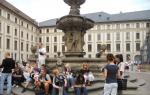
Belarus has collected many features of other nations, but at the same time it has managed to preserve its originality. Today in Belarus there is a huge number of religious, historical and architectural monuments. These are numerous cathedrals, churches, castles and fortresses.
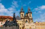
What to see in Belarus- the most visited places in Belarus are the Brest Fortress, Mir Castle and St. Sophia Cathedral. The nature of Belarus is one of the most beautiful in all of Europe. Natural attractions are the heritage and treasure of Belarus. The most famous of them are Braslav Lakes, Berezinsky Nature Reserve and Belovezhskaya Pushcha.
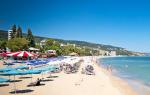
Those who are tired of the bustle of the city and are looking for a relaxing holiday mainly go on holiday to Belarus. Most tourists relax on the lakes (Naroch, Braslav Lakes). Some travelers prefer ecotourism and tours of the cities of Belarus.
In winter, tourists will also find something to do, since ski resorts are open and successfully operating and developing in Belarus. The best of them is considered to be “Logoisk”, which is often called “Belarusian Switzerland”. The second most visited winter resort is Silichi. Health-improving and therapeutic forms of recreation are also actively developing in the republic. Thanks to the beautiful nature and Belarus there are many sanatoriums, boarding houses and holiday homes open.
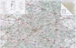
We present to your attention a map of highways in Belarus. For more convenient use, the map shows not only the main roads, but also cities and other settlements. The proposed road map of Belarus will help you plan your trip, plotting the most optimal route and subsequently saving both time and money on fuel.
Car map of Belarus online
Map of highways in Minsk, Minsk region and all of Belarus: currently, the network of public roads in the Republic of Belarus has a length of 94.797 km, of which 15.476 km are republican roads, and 70.192 km are local roads. All roads in the country are paved.
Detailed map of highways in Belarus on a scale of 1: 850,000
The presented road map is very detailed - in addition to roads, it shows cities, villages, hamlets, and towns. The map shows highways, highways of republican and local significance, and also indicates road service facilities (gas stations, service stations, car service stations, hotels, checkpoints for road transport).
To increase you must click on the image!

We also present to your attention a map of toll roads in Belarus - from July 1, 2013, the BelToll electronic toll collection system was introduced on the territory of the Republic of Belarus. The system is based on specialized short-range radio communications technology used throughout the world. The advantage of the technology is that there is no need to stop the vehicle at the toll collection point.
Above the toll roads there are metal portals with transceivers for collecting tolls. Information is exchanged with the on-board device in the car, which is installed on the windshield.

When a vehicle passes through the payment collection portal, the required amount is automatically debited from the account of the installed on-board unit. An account is created during user registration in the system.
If the total weight of the vehicle does not exceed the technically permissible standard of 3.5 tons, and the vehicle is registered in the countries of the Eurasian Economic Union (Belarus, Russia, Kazakhstan, Kyrgyzstan and Armenia), the vehicle is exempt from tolls.
Tolls on roads included in the BelToll system are mandatory for the following vehicles:
- power-driven vehicles with a technically permissible total weight of more than 3.5 tons;
- mechanical vehicles with a technically permissible total weight of not more than 3.5 tons, registered outside the Eurasian Economic Union.
Please note that the maps presented on the site may be out of date and contain some errors and inaccuracies, as they are posted on the site for informational purposes only.
Belarus is a country located in Europe and does not have access to the sea. It has borders with Poland, Lithuania, Latvia, the Russian Federation, and Ukraine.
From the map you can see that the territory of the state in the longitudinal direction occupies about 645 km, and in the transverse direction - about 550 km, in total it occupies about 210 thousand square kilometers of land. Here, in the city of Polotsk, the geographical location of the center of Europe is officially marked. Administratively, the country is divided into six regions, in which the total population is 9.5 million people (according to the 1998 census). A unique feature of the relief of Belarus is the predominance of flat terrain with significant swamps in the lowlands, which is why swamps received the figurative definition of “ the fifth element" in the common people.
Belarus is a presidential republic with a unitary government system. The capital is the city of Minsk. There are more than a hundred cities in the vastness of the state, the largest of which are Grodno, Vitebsk, Mogilev, and Gomel.
A number of important communication routes between Western countries and eastern European countries run through Belarus.
See where Belarus is located on the world map (satellite view):
Sorry, the card is temporarily unavailable

Detailed administrative and road map of Belarus roads free download.

A small but convenient map of Belarus with main cities and physical objects.
Free online map of Belarus. The tourist map contains markers with the exact location of all recreation centers, mini hotels, cottages and where you can stay and relax. Additionally, on the interactive map you can see marked ones and create a convenient route for your trip around Belarus.
To make it easier to use the interactive map of Belarus, it has several controls. To change the scale, use the +/- slider to the left of the map or the mouse scroll wheel. You can change the active map layer, measure distance, plot a route on the map and view traffic jams on the roads of Belarus.
Online map of Belarus from satellite (Google / Google)
Interactive satellite map of Belarus with roads. On a Yandex map from a satellite, you can view virtual panoramas of streets and roads, just drag the icon with a “man” from the upper left corner of the map to the area of the map that interests you. Panoramas are not available for all cities and towns; sections of streets with panoramas are highlighted in blue when you drag the icon.
Belarus is a wonderful and unique country. European purity and severity are surprisingly combined here with smiling and good-natured residents, modern buildings - with ancient suburbs and corners of ancient architecture.
Clean air, blue rivers, cool lakes, beautiful forests and pastures - all this is why you should definitely visit this hospitable country.
Interactive map of Belarus
Below is an interactive map of Belarus online from Google. You can move the map left and right, up and down with the mouse, and also change the scale of the map using the “+” and “-” icons, which are located at the bottom on the right side of the map, or using the mouse wheel. In order to find out where Belarus is located on the world map, use the same method to reduce the scale of the map even further.
In addition to the map with the names of objects, you can look at Belarus from a satellite if you click on the “Show satellite map” switch in the lower left corner of the map.
Map of Belarus with cities
Below is a map of Belarus by region with cities. To see the map in full size, click on it and it will open in a new window. You can also print it out and take it with you on the road.

You were presented with the most basic and detailed maps of Belarus, which you can always use to search for an object of interest to you or for any other purposes. Have a nice trip!