Abstract economic and geographical characteristics of the country Libya. Libya - information about the country, attractions, history Geographical location of the country Libya
Libya- a state in North Africa. In the north it is washed by the Mediterranean Sea. It borders on Egypt in the east, Sudan in the southeast, Chad and Niger in the south, Algeria in the west, and Tunisia in the northwest.
The name of the country comes from the name of one of the local tribes - the Livu. The word "jamahi-riya" means "democracy".
Official name: Great Socialist People's Libyan Arab Jamahiriya
Capital: Tripoli
The area of the land: 1760 thousand sq. km
Total Population: 6.46 million people
Administrative division: The state is divided into 46 municipal districts.
Form of government: Republic.
Governing body: Revolutionary leadership.
Population composition: 90% are Libyans (Arabs and Berbers), also: Tuaregs, Tuba.
Official language: Arab. Italian was once widely used, especially among the educated segment of Libyan society. During the years of the British administration (1943-1951), the English language became widespread, which became especially popular with the appearance of American and British oil companies in Libya.
Religion: 97% are Sunni Muslims, 2% are Catholics, 1% are Christians (Coptics).
Internet domain: .ly
Mains voltage: ~127 V/230 V, 50 Hz
Country dialing code: +218
Country barcode: 624
Climate
On the coast of Libya, the climate is Mediterranean subtropical, in the south - desert tropical with sharp seasonal and daily temperature fluctuations and great dryness of the air. The average temperatures of the coldest month - January - in the north of the country are 11–12 ° C, in the south 15–18 ° C, the temperatures of the warmest month - July are 27–29 ° C and 32–35 ° C, respectively. In summer, daytime temperatures are above 40 -42 ° C, maximum - more than 50 ° C. In 1922, in El Azizia, 80 km southwest of Tripoli, a record high temperature of 57.8 ° C was recorded.The coastal areas of the country receive the most rainfall. In Benghazi the average annual precipitation is 250 mm, in Tripoli 360 mm. The nearby mountains and the Barqa el-Bayda plateau are slightly more humid. Not far from them there are areas where less than 150 mm of precipitation falls per year. Rainfall on the coast occurs during the winter months, and summers are very dry and hot. The country's deserts often receive only 25 mm of precipitation per year. There are often hot, drying winds with dust storms - gibli and khamsin.
Most of the territory of Libya, with the exception of certain coastal regions, mountains and oases, is characterized by an extremely dry climate and is unsuitable for agriculture.
Geography
Libya is a country in the central part of North Africa, has access to the Mediterranean Sea. In the north it is washed by the Mediterranean Sea, in the east it borders with Egypt, in the southeast with Sudan, in the south with Chad and Niger, in the west with Algeria and in the northwest with Tunisia. Most of the country's territory is occupied by desert.
Most of the territory is a flat plain with heights from 200 to 500 m. The parts of the plains are separated by extensive depressions, the largest of which lies in the northeast of the country. The western part of Libya is separated from the eastern part by a chain of mountain ranges and ranges.
On the northeastern coast of the Mediterranean Sea there is a small El-Akhdar plateau (less than 900 m). Its name means "green mountains": subtropical vegetation grows in this area. In the southeast, in the spurs of the Tibesti highlands, is the highest point of the country - the extinct volcano Bette (2286 m). The lowest absolute elevation (-47 m) is located in the Sakhat Guzayil depression.
Flora and fauna
Vegetable world
The natural vegetation of the deserts is very poor - these are dry-loving thorny plants, saltwort, rare shrubs, single trees in the valleys of the oueds, where moisture is stored in the alluvium. Vast spaces are almost completely devoid of vegetation. In more humid areas of the coast, on gray brown soils and gray soils, cereals, tamarisks and other shrubs, and certain types of acacias grow.
On the slopes of the mountains in the north of Cyrenaica, vegetation such as the Mediterranean maquis and islands of forests of Aleppo pine, juniper, and cedars (now almost single) have been preserved. Between the zone of coastal subtropical vegetation and the deserts stretches, several tens of kilometers wide, a strip of semi-desert vegetation with a sparse grass cover dominated by hard-leaved xerophytic grasses, wormwood and salt-loving plants.
Animal world
The fauna of deserts is not rich. On the northern outskirts there are many predators - these are jackals, hyenas, fennec foxes. Of the ungulates, you can occasionally see small herds of gazelles, and in the extreme south - antelopes. As in all deserts, reptiles, insects, spiders, scorpions are richly represented. Many migratory birds pass over Libya, and some of them even spend the winter here.
There are many birds in oases, where they, especially passerines, cause great damage to poor crops. Small rodents that live everywhere, even in almost waterless parts of deserts, are also a scourge.
Banks and currency
Libyan dinar (international designation - LYD, domestically - LD), equal to 1000 dirhams. Banknotes in denominations are 10, 5 and 1 dinar, 1/2 and 1/4 dinar. Coins in denominations of 100 and 50 dirhams.
Banking hours: 08.00-12.00 from Saturday to Thursday (winter), 08.00-12.00 from Saturday to Thursday and 16.00-17.00 from Saturday to Wednesday (summer).
Diner's Club and Visa credit cards have limited use only in large hotels and at the airport.
Traveler's checks are not accepted at all due to existing sanctions imposed by the US Government. Withdrawing cash from an ATM is extremely difficult in this country, since in 2007 there were only three ATMs in the whole of Libya that allow cash withdrawals using Visa or Mastercard. Two of the three ATMs are located in Tripoli (Bank of Commerce and Development) and one in Benghazi (Funduq Tibesti Hotel lobby).
Currency can be exchanged in banks and officially authorized exchange offices. There is also a black market for currency exchange, but when exchanging small amounts, it does not differ much from the official rate.
Useful information for tourists
The traditional drink of Arab countries is coffee. The process of preparing and drinking it is a complex ritual. First, the grains are fried, stirring them with a metal stick, after which they are crushed in a special mortar with the obligatory observance of a certain rhythm. Coffee is brewed in copper or brass vessels similar to teapots. The finished drink is served in small cups, in order of seniority.Guests are offered coffee three times, after which decency requires thanking the owner and refusing. Coffee is drunk without sugar, but with the addition of spices - cloves, cardamom, and in some countries - saffron and nutmeg. The diet in Arab countries is two meals a day: usually a very hearty breakfast and an equally hearty lunch.
Geographical location of Libya.
LIBYA, Socialist People's Libyan Arab Jamahiriya (arab. Al-Jamahiriya al-Arabiya al-Libia ash-Shaabiya al-Ishtirakiya), a state in the North. Africa. The area of Libya is 1759.5 thousand sq. km. The population of Libya is 5.7 million people (2004); Libyan Arabs - St. 80%, Tuareg Berbers, Tubu. The official language is Arabic. The state religion is Islam.
Government structure of Libya.
The governing body of Libya is the "Revolutionary Leadership" (officially located outside the system of state power). Libya's legislative body is the General People's Congress.
Administrative division of Libya.
According to the administrative-territorial division, Libya consists of 13 municipalities.
Libyan population.
The population of Libya is 5.7 million people (2004), including Libyan Arabs - St. 80%, Tuareg Berbers, Tubu. The official language in Libya is Arabic. The state religion of Libya is Islam.
Climate, relief and natural resources of Libya.
Most of the surface of Libya is a plateau, an altitude of 200-600 m, in the east - the Libyan desert, in the south - the forts of the Tibesti highlands (height up to 2286 m).
The climate is tropical, desert, subtropical in the north. Average temperatures in July are 27-35 °C, in January 11-18 °C. Precipitation is 100-600 mm per year in the north and south, 25 mm in the Libyan Desert.
There are no rivers in Libya; significant reserves of groundwater. Deserts, on the coast - subtropical semi-desert vegetation. Kuf National Park.
Economy and industry of Libya.
The basis of the Libyan economy is the oil and oil refining industry. Share in GDP (1992,%): industry 48 (including mining 25), agriculture 7. Cement, textile, metallurgical, food and flavor industries. Electricity production 18 billion kWh (1995).
They cultivate grains, vegetables, peanuts, and tobacco. Fruit growing (dates, citrus fruits), viticulture. Extensive livestock farming. Fishing. There are no railroads. The length of roads is 81.6 thousand km (1996). Export: oil, oil products and gas (96%), chemical products, citrus fruits, etc. Main foreign trade partners: Italy, Germany, Spain, etc.
The monetary unit is the Libyan dinar.
History of Libya.
In the 1st half. 1st millennium BC e. Phoenician colonies were founded in western Libya; in the 7th century. in the east - Greek city-colonies. All R. 5th-2nd centuries a significant part of Libya (in the west) under the rule of Carthage, in the 2nd century. BC e. - 5th century n. e. - Rome.
After the arrival of the Arabs (7th century), Islam and the Arabic language spread. In the 11th century Libya was subjected to a devastating invasion of nomads. In the 16th century - 1912 as part of the Ottoman Empire.
In 1912-1943 Italian colony. In December 1951-1969 an independent kingdom. On September 1, 1969, the royal regime was overthrown and a republic (LAR) was proclaimed. In 1977, a decree was adopted establishing in Libya a "regime of people's power" (the so-called direct people's democracy); The country was renamed the Socialist People's Libyan Arab Jamahiriya. In 1979, the revolutionary leadership in Libya was headed by M. Gaddafi (in 1969-1977, chairman of the Revolutionary Command Council). From the end 1980s steps are being taken to liberalize the economic and political spheres. Encourage cooperative forms of ownership, private trade while maintaining the public sector.
Socialist People's Libyan Arab Jamahiriya.
The name of the country comes from the name of one of the local tribes - the Livu. The word "jamahiriyya" means "democracy".
Capital of Libya. Tripoli.
Libya Square. 1759540 km2.
The population of Libya. 5241 thousand people
Administrative divisions of Libya. The state is divided into 46 municipal districts.
Libya's form of government. Republic.
Libyan governing body. Revolutionary leadership.
Supreme legislature of Libya. General People's Congress.
Supreme executive body of Libya. Supreme People's Committee (VNCOM)
National language of Libya. Arab.
Religion in Libya. 97% are Sunni Muslims, 3% are .
Ethnic composition of Libya. 97% are Arabs and Berbers.
Currency of Libya. Libyan dinar = 1000 dirhams.
Sights of Libya. In Tripoli - the Museum of Natural History, the Archaeological Museum, the Ethnographic Museum, the Museum of Epigraphy, the Museum of Islam, the Triumphal Arch in honor of Emperor Marcus Aurelius, the Karamanli and Gurgi Mosques, in Al-Hum, the Leptis Magna Museum. Along the coast there are ruins of Phoenician and Roman settlements, including Roman baths.
Useful information for tourists
The traditional Arab drink is coffee. The process of preparing and drinking it is a complex ritual. First, the grains are fried, stirring them with a metal rod, after which they are crushed in a special mortar with obligatory observance of a certain rhythm. Coffee is brewed in or brass vessels similar to teapots. The finished drink is served in small cups, in order of seniority. Guests are offered coffee three times, after which decency requires thanking the owner and refusing. Coffee is drunk without, but with the addition of spices - cloves, cardamom, and in some countries - saffron and nutmeg. The diet in Arab countries is two meals a day: usually a very hearty breakfast and an equally hearty lunch.
1. Economic and geographical position……………………………………....3
2. Natural resources and conditions……………………………………………...4
3. Characteristics of the population and labor resources…………………………….6
4. Largest cities……………………………………………………………………………….7
5. Structure of the economy………………………………………………………8
6. Specialization of industry…… ……………………………………..9
7. Specialization of agriculture………………………………………...10
8. Role in the territorial division of labor………………………………… 11
9. Development prospects……………………………………………………..12
10. Conclusion with an assessment of the positive and negative features of the economic and geographical position………………………………………………………. 13
Literature…………………………………………………………………….14
- Economic-geographical location
Before oil development began, Libya was one of the poorest countries in Africa and did not have much prospects for economic development. Most of the Libyans were employed in agriculture, which was very unproductive due to the lack of rainfall and the lack of suitable land for cultivation. But by the mid-1960s, thanks to the development of oil fields, Libya was on a par with countries such as Venezuela, Kuwait and Saudi Arabia. In 1983, per capita income increased to $8,480. The rapid development of the oil industry left all other sectors of the economy far behind. Libya's national industry is just beginning to emerge and still has to import food to meet the needs of its growing population. Another problem is the lack of qualified personnel. At the end of the 1980s, more than 500 thousand foreigners worked in Libya.
2. Natural resources and conditions
Libya has famous large genera. oil, natural gas, hall. ores and small genera. potassium and magnesium salts, soda, phosphorites, gypsum, limestone, clay and coal. Mineral deposits also include marble, bentonite, silica sand, and there are occurrences of gold and base metals.
Libya has large deposits of oil, natural gas, iron ore and small deposits of potassium and magnesium salts, soda, phosphorites, gypsum, limestone, clay and coal.
The country has identified 86 oil and 8 gas fields in the oil and gas regions of Hamra in the west and Sirte in the east. The oil and gas bearing area of Hamra is confined to the eastern part of the Algerian-Libyan basin, filled with Paleozoic predominantly terrigenous marine and continental sediments up to 4 km thick, overlain in the north by sandy-clayey and calcareous sediments (up to 2 km) of Mesozoic age. Here, 35 oil and gas fields have been identified in Ordovician-Lower Triassic sediments. High porosity reservoirs (18-25%). The largest deposits are Hamra and Emgayet. Light oils (up to 840 kg/m3), low-sulfur. In the oil and gas bearing area of Sirte, which is part of the Caxapo-Mediterranean oil and gas bearing basin, Cambrian-Ordovician sandstones, dolomites and reefogenic limestones of the Upper Cretaceous, limestones and reefogenic limestones of the Paleocene - Eocene (up to 12 horizons) are productive. The deposits are associated with gentle brachyanticlines. The deposits are strata domed (massive in limestones), mainly at a depth of 900-2500 m. 80 deposits have been identified, incl. the giant Serir field and the largest (with recoverable reserves of over 100 million tons) oil fields Amal, Nafura, Raghuba, Intisar, Nacep (Zelten), Bahi, Baxa, Samakh, Defa, etc., as well as the Khateyba gas field (339 billion tons). m3). Light and medium oils (up to 860 kg/m3).
Coal reserves in the country have not been estimated. Coal occurrences are established east of Murzuk, where a coal layer about 10 m thick lies in Nubian sandstones (Zavila), and in the north there is a coal-bearing horizon in Lower Cretaceous deposits (Nalut, Kikla, Tarhuna).
Sedimentary iron ore deposits are concentrated in the Ash-Shati region. The ore-bearing strata of the Upper Devonian are represented by clayey-sandy deposits with interlayers of limestone and marls. The total length of the ore-bearing zone is 180 km, width is 10-15 km, the thickness of the ore-bearing member is 50 m. In the section, 5 productive layers with a thickness of 4-9 m are identified. The ores are represented by hematite, goethite, and siderite of oolitic structure. The largest deposits: South Tarut (total reserves 640 million tons, Fe content 50%), Ashkeda (475 million tons, 51.7%), Ed-Duesa and El-Auja (700 million tons, 45%) and others
Gypsum deposits are confined to Lower Jurassic deposits and are common in the north-west of Tripolitania, in the area of Er-Rumiyah.
The thickness of the gypsum-bearing stratum is 270 m. The deposits of potash and magnesia salts are associated with Miocene deposits in a drainless lake basin near the city of Marada. Soda is extracted from the lakes of the Murzuk depression, the largest lakes reach a size of 60x450 m at a depth of 0.5-1 m. The concentration of salts in the brine is 23-205 g / l of dry residue. When lakes dry up, the thickness of the salt crust is 15-30 cm (Na2CO3 content 34.1-66.5%). In Libya, deposits and manifestations of phosphorites are known in the deposits of the Upper Triassic and Maastricht-Paleogene age in the northwest. Lenticular industrial layers of sandy granular phosphorites have a thickness of 0.2-0.3 m, the content of P2O5 is up to 31.4%. Clay deposits are associated with deposits of the Lower Cretaceous in the area of the city of Garyan, limestone (for cement production) - with Miocene deposits in the area of the cities. Homs and Benghazi.
Mining. General characteristics. Libya's place in the global mining industry is determined solely by the oil and gas industry. Libya is one of the major oil producers: in 1981, it accounted for 2.7% of all oil production in industrialized capitalist and developing countries.
Natural gas production is also important for the national economy. The main fisheries are located in the south and southeast of the Greater Sirte (map).
Other types of minerals available in the country, with the exception of construction mineral raw materials, are practically not mined. It is planned to develop the iron ore deposit Esh-Shati by open method (1984). The number of people employed in the mining industry is 21.2 thousand (1980).
3. Characteristics of the population and labor resources
Thanks to rapid growth rates from 1973 to 1998, the country's population increased from 2.2 to 5.7 million people. In the 1970s, annual population growth rates exceeded 4%. According to estimates for 2010, 6 million 461 thousand people lived in the country.
The average life expectancy of Libyans is 77.47 years (women - 79.88 years, men - 75.18 years). Infant mortality is approx. 20.87 deaths per 1000 births.
The average age of Libyans is approx. 24 years old.
The vast majority of the population is concentrated in a narrow coastal zone and in oases. People are increasingly moving from rural areas to cities; by 2008, almost 78% of the population lived in the city.
Libya has two large cities - Tripoli (1.5 million inhabitants in 1990) and Benghazi (800 thousand inhabitants). There are also a number of small towns. These include Misurata (360 thousand people), Ez-Zawiya (280 thousand), Sebha (150 thousand), Tobruk (75.3 thousand), Al-Beida (67.1 thousand) and Ajdabiya ( 65.3 thousand). New cities arose near the oil terminals: Es Sider, Ras al-Anuf, Marsa al-Bureika, Al-Zuwaytina and Marsa al-Khariga.
External migration of the population affects the labor market of the region, changing not only the quantitative characteristics of labor resources, but also the qualitative ones. Thus, external migration affects the size, natural movement and structure of the population, and, consequently, that part of it that acts as labor resources. Undoubtedly, external migration also brings changes to the professional structure of the population. In the region under study, people who have received higher education quite often leave their homeland. For example, according to the World Bank, 10.3% of all those who received higher education left Morocco, 9.6% in Tunisia, 6.5% in Algeria, 4.2% in Egypt, and 3.8% in Libya.
4. Largest cities
The largest city in Libya is Tripoli, the capital of the country and the center of the historical region of Tripolitania in the west of the country. The second most populous city is the city of Benghazi - the center of the historical region of Cyrenaica (Pentapolis) in the east of the country. Other relatively large cities are also located on the Mediterranean coast: Misrata and Homs in Tripolitania, Tobruk, Derna, Al-Bayda, Al-Marj and Ajdabiya in Cyrenaica. The interior desert regions of the country are characterized by the oasis cities of Ghadames, Sebha, Ubari and Wazin.
5. Farm structure
In addition to oil production, agriculture is an important component of the economy. The rural population cultivates the land in the narrow coastal strip of Tripolitania, using atmospheric precipitation in winter and irrigation from wells in summer. Around Tripoli, in the commercial horticulture area, citrus fruits, dates, olives and almonds are grown. In the southern oases, water from underground sources is used to irrigate fields. In the presence of a sufficient amount of precipitation, barley is cultivated on the periphery of the uplands. Arable land makes up only 1% of the country's area, and only 1% of it is included in the artificial irrigation zone. Since 1979, work has been underway to build a "great artificial river" - a conduit designed to transfer water from 250 underground wells from the Tazerbo and Sarir oases in the Sahara desert to the country's coast. By 1993, 1,800 km of pipelines and canals had been laid, roads and reservoirs had been built. In Cyrenaica, crops, olives and fruit trees are cultivated on the Barka el-Bayda plateau. Libya has 8 million hectares of grazing land in Tripolitania and 4 million hectares in Cyrenaica. The El Akhdar Plateau region of Cyrenaica is home to nomadic pastoralists.
6. Industry specialization
The Libyan government is making efforts to expand and diversify the sectoral structure of the industry. In the early 1970s, new industries emerged, including cement and metal products. In subsequent years, a number of contracts were signed with Western European, Yugoslav and Japanese firms for the construction of several nuclear and thermal power plants, as well as heavy industry enterprises. At the same time, it was envisaged that some of these enterprises would use crude oil as a raw material. Among the largest enterprises in the manufacturing industry, the metallurgical plant in Misurata stands out, which produced up to 1.5 million tons of steel and rolled products in 1996, plants for the production of pipes and electric cables; assembly of cars and tractors has been established. Light and food industries are poorly developed. Traditional industries include the extraction of sea sponges, salt evaporation in the coastal zone and various handicraft industries: the manufacture of leather goods, copper, tin, ceramics and carpet weaving. There are also small enterprises in the processing of agricultural products, timber, paper, tobacco, textiles and soap.
The number of industrial workers is small, but is constantly growing as the oil industry develops and enterprises related to oil production and refining are built. Since almost half of the oil industry's workforce was made up of foreign workers, in 1971 the government encouraged foreign companies to hire as many Libyans as possible.
Unlike most countries in the region, Libya has a relatively developed manufacturing industry. The most important industrial enterprises were founded during the Italian colonial presence. The basis is made up of metalworking and engineering enterprises in Tripoli. Although most of the equipment at the enterprises remains outdated (sanctions of the international community), Libya not only independently provides itself with modern military equipment, but is also the largest exporter of weapons to African countries.
7. Specialization in agriculture
Agriculture employs 17% of the workforce and contributes 4.2% of GDP (in 2009).
Irrigated agriculture is developed in the northern part of Libya. Almost all year round, potatoes, cabbage, onions, tomatoes, and lemons are supplied directly from the field. There are several harvests per year. Grain crops are grown. Livestock farming is represented by raising sheep and camels. Poultry farming is developed. Water comes from underground lakes in the Sahara Desert by gravity (water sources are located half a kilometer above sea level). Tuna, sardines, and squid are caught in the Mediterranean Sea. Libya's own production does not meet the country's food needs; most food products are imported. Italian spaghetti, Polish milk and Ukrainian sausages that do not contain pork are always on sale.
8. Role in the territorial division of labor
It is the export of oil and oil products that determines the place of Libya in the international division of labor. In this monocultural focus, Libya is similar to many other developing countries. But while most of the developing countries of Africa formed their monocultural economy in the colonial era, and this predetermined their place in the international division of labor, in Libya this process began in the 1970s. Until the 1960s Libya - one of the poorest countries in the world - had no chance at all to join the international division of labor. At the same time, the focus on oil exports creates restrictions for the country, as it makes the Libyan economy highly dependent on the situation on the world energy market, but, entering OPEC, the country is able to influence world oil prices and policy in this area as a whole.
Since the process of a clear focus on oil exports only began in the 1970s, it can be assumed that reforms aimed at diversifying the Libyan economy can be implemented more easily than in other African countries. In the future, Libya will take an important place in the international division of labor as an exporter of natural gas. Although Spain is now the only buyer of Libyan natural gas, plans are already being developed to develop the Libyan gas industry, in which
etc.................
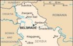
Libya on a map of Africa
(all pictures are clickable)


States, like people, have their own destiny, their own history. Libya and its inhabitants have had a difficult fate. Unfavorable climatic conditions, a difficult economic situation were complicated by the war and political instability. But this hot country on the Mediterranean coast deserves attention and attracts close attention from all over the world.
Geographical position
From the Maghreb countries (states west of Egypt) Libya occupies the extreme east. The advantage of the geographical position lies, first of all, in the fact that its northern tip runs along the Mediterranean coast. Access to a strategically and economically important water body influenced the history of the state and its further development.
The Libyan coastline is the longest among all African countries located in the Mediterranean region. It is 1770 km, and that part of the Mediterranean that adjoins the territory of the state is called the Libyan Sea.
The mainland south of the country borders Niger and Chad. In the west, Libya neighbors Algeria and Tunisia. In the east there is a long border with Egypt, in the southeast - with Sudan.
The total area is 1,759,541 km², this is the 4th largest among all African states.
Libya is divided into three regions:
- Cyrenaica is an elevated northeastern region that includes the Barka el Bayda plateau near the Mediterranean coast;
- Tripolitania is the western plain of Jefar and the adjacent areas of the sea coast. This is the most favorable area for human life and agricultural activities;
- The Fezzan is a dry sandy plain in the south. Its desert landscape is enlivened by only a few oases.
The subtropical Mediterranean type of climate of the coastal areas of northern Africa, when moving south (inland), is replaced by a tropical desert climate. The Libyan tropics are characterized by extreme dry air and huge amplitudes of daily temperature fluctuations. The difference in climatic conditions between the north and south is quite noticeable.
In the coldest month of the year, January, the average temperature in the northern part of Libya is +12 °C, in the south of the country they are much higher - up to +18 °C. The July heat in the north is moderated by the proximity of the sea; the average temperature here is about +28 °C. The southern regions live in conditions of abnormal heat with an average July temperature of +35 °C, the usual daily values exceed 42 °C in the shade.
In 1922, the highest air temperature in the entire history of observations on Earth was recorded at the Al-Aziziya weather station (80 km southwest of Tripoli). The record was almost +58 °C.
The amount of precipitation is uneven. The largest number is found in the Mediterranean region. The average annual amount is 250 mm, in some areas up to 360 mm. Almost all of them fall in winter, but summer is always dry.
In continental desert areas, no more than 25 mm of precipitation falls per year. Dry winds and dust storms (sirocco) are frequent here.
Flora and fauna
Unfavorable climatic conditions do not contribute to the formation of permanent vegetation cover; more than 90% of Libya's territory is completely devoid of it. Only on the coast, mountain slopes and oases can you find green plants - date palms, olive, orange and pistachio trees, juniper.
Traditional desert inhabitants are gazelles and antelopes, hyenas and wild cats, and various reptiles. Vultures, hawks and eagles soar above them.
State structure

Libya map
The full official name is the state of Libya. The form of government is a republic. The state system is the Jamahiriya, or people's state (people's power). Legislative power is exercised by the General People's Congress, executive power is exercised by the Supreme People's Committee. All political parties were abolished in 1977.
Italian civil law and Islamic law form the basis of the country's legislation. After the overthrow of Gaddafi, control passed into the hands of the National Transitional Council, which included 31 representatives of the largest Libyan cities. Administrative division: 13 districts.
The official language of the country is Arabic. 97% of the inhabitants are Sunni Muslims.
Population
The total population in 2015 is approaching 6.7 million. It is extremely unevenly settled throughout Libya. The most populated are the coastal northern regions of Tripoletania and Cyrenaica, 9/10 of the total population lives here. The desert expanses are poorly populated, the population density in them is less than 1 person per km².
It is noteworthy that the average life expectancy of Libyans is quite high (77 years), and the average age of the inhabitants is 24 years.
The national composition is homogeneous: 98% Arabs, the remaining 2% are Berbers, Greeks, Egyptians, Italians, Malians, Tuareg, etc.
Economy
Until recently, Libya was a backward agricultural country. But in the 60s of the last century, thanks to the development of the oil industry, the state began to develop rapidly. The development of oil fields has become the basis of the economic foundation.
Agriculture remains an important industry. In areas with sufficient moisture, horticulture is developed, and barley is cultivated on arable land. Since 1979, the country has been building the so-called "great artificial river", which will help expand the amount of agricultural land. In Libya, vast areas of pastures - 8 million hectares, which are developed by nomadic pastoralists.
At the end of the twentieth century, new enterprises for the production of metal products and cement appeared in Libya. Heavy industry enterprises and power plants were built with the help of foreign specialists.
A former province of the Ottoman Empire, later a colony of Italy, Libya remained a dependent for a long time. Only in 1951 did she gain freedom, and King Idris I began to rule the country. After the military coup of 1969, the state was headed by Muammar Gaddafi. For forty-two years he was the sole leader (from 1977 to 2011).
The Gaddafi regime was overthrown by rebels financed by foreign countries.
These events entailed devastating consequences for the country. The population, the economy, and the political structure suffered. To this day, the war in Libya continues, the recognized government of the country is trying to cope with strong Islamist groups. Civil war and political instability bring grief and ruin.
Attractions
On the Mediterranean coast, ruins of Phoenician settlements, ruins of Roman dwellings and baths have been preserved.
Libya's main values are concentrated in Tripoli. These are the Archaeological and Ethnographic Museum, the Museum of Islam, the Triumphal Arch of Marcus Aurelius, and unique mosques.
The Libyans have something to demonstrate to lovers of ancient antiquity; they are proud of their unique nature. We can only hope that the country will soon find the long-awaited stability and will happily welcome guests from all over the world.
Libya photo