Which rivers does the Volga River connect to? But where does the Volga flow?
The Volga River is one of the largest river bodies of water on our entire planet. In addition, if we talk about the scale of Europe, then the Volga is considered the longest river on the mainland. This is truly a historical body of water, the length of which is more than 3.5 thousand kilometers.
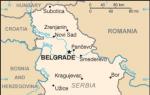
The river stretches not only through several of the largest regions of Russia, but also affects Kazakhstan.
And below we want to take a closer look at the question of why the Volga River was called the Volga.
Origin of the name of the Volga River
There are several versions of the origin of the name of the river. However, many scientists agree that the Volga was named Volga from the Old Church Slavonic word “Vlga”. This is exactly what the river was called in ancient times. This name, in turn, came from the Proto-Slavic word “Vьlga”, which could be translated into modern Russian as “Moisture”.
Also, a significant part of etymologists suggest that the name of the river could have its roots in the Baltic languages, since the upper part of the reservoir was located in an area where many names are of Baltic origin.
So, in the Baltic languages, the name of the river could come from “Ilga” - “Long” or “Long”.
Of course, both of these options resemble genuine ones, since both the concept of “Long” and, of course, “Moisture” are optimally suited to this river. However, there is currently no exact origin.

In addition to the fact that the Volga is the longest river in Europe, and one of the largest in the world, there are also some other interesting facts associated with it that cannot but be remembered:
- The scale of the reservoir has influenced the fact that it systematically feeds more than 1 thousand other rivers with its waters;
- The scale of the Volga is partly a consequence of the fact that the river is constantly fed by thawing snow. Scientists confirm that approximately 2/3 of all water in the Volga comes from snow;
- Due to the construction of reservoirs associated with the river delta, its length has decreased by approximately 160 kilometers;
- Most cities adjacent to the Volga are supplied with electricity from hydroelectric power plants, which, in turn, operate due to the flow of the river;
- The area adjacent to the Volga is home to such exotic animals as pelicans and even flamingos.
Now you know not only why the Volga was called the Volga, but also what interesting facts, as well as figures regarding this reservoir, make you understand its importance and scale.
The Volga River is the largest river in Europe, the most abundant in Russia. This is the longest river in the world that flows into an inland body of water - the Caspian Sea.
The river basin occupies an area equal to half the area of Europe.
The Volga River (a brief description is given below) has more than one hundred and fifty tributaries - this is one of the record figures on the planet. On average, it takes water 37 days to travel from source to mouth, since the current speed is approximately 4 km per hour. The Volga is one of the few rivers that has its own holiday - in Russia May 20 is considered to be Volga Day.
Volga River: a brief description of the geographical location
The Volga flows through the territory of Russia, only a small branch of the Kigach goes east to the Atyrau region of the Republic of Kazakhstan. The Volga River (a brief description for children will be given below) begins in the Tver region near the village, which is called Volgoverkhovye.

Here its source is a small stream, which after a few kilometers crosses the lakes - first Small, and then Big Verkhity, which give strength to the great river. About a third is washed by the waters of the Volga basin. The Volga and its tributaries flow through the territory of thirty administrative regions of Russia and one region of Kazakhstan.

The mouth of the river is located in and represents the largest delta in Europe from numerous branches that flow into the Caspian Sea.
Historical information
The Volga, as an important trade artery of Eurasia, has been known to mankind for a long time. Having a great length and favorable geographical position, it was especially popular among traders. Back in the 5th century BC, Herodotus, an ancient Greek philosopher, mentioned it in his treatise on the campaign of King Darius against the Scythian tribes. He named the Volga Oar. In ancient Arabic chronicles it is listed as Itil.
By the 10th century AD, a well-known link connecting Scandinavia with Arab countries had been formed. Large trading centers were formed on the banks of the great river: Khazar Itil and Bulgar, Russian Murom, Novgorod, Suzdal. In the 16th-18th centuries, such large cities as Saratov, Samara, and Volgograd appeared on the map of the Volga region. Here, in the Trans-Volga steppes, the rebel Cossacks and peasants were hiding. Giving a brief description of the Volga, it should be noted that at all times it performed an important economic function - it connected ports within the country and was a highway for communication between different states. In the middle of the 20th century, after its formation, the political function of the river increased - access to the Azov and Black Seas, and therefore to the World Ocean.
Nature of the Volga basin
The Volga River is rich in natural resources. A brief description of the main plant and animal species is given below. There are four types of plants in the water: algae, submerged aquatic plants, aquatic plants with floating leaves, and amphibians. A wide variety of herbs grow in the coastal areas (wormwood, sedge, mint, marshmallow, spurge), as it is covered with extensive meadows. There is an abundance of blackberries and reeds. For hundreds of kilometers along the Volga there are forest belts with birch, ash, willow, and poplar trees. This is a brief description of the Volga River and its flora.

The fauna of the river is also diverse. About fifty species of fish live in the water, including sturgeon, beluga, and stellate sturgeon. The coastal expanses are densely populated by birds and animals. The Volga Delta, where the unique Astrakhan Nature Reserve is located, has a special nature. It is home to many insects, birds, mammals and a wide variety of plants. Some representatives of the fauna existing in the reserve are listed in the Red Book: mute swan, pelican, white-tailed eagle, seal.
Large cities of the Volga region
The Volga region has an advantageous location both geographically and economically. Developed areas of the Urals, Central Russia and Kazakhstan are nearby. The Volga River supplies populated areas with water and energy. A brief description of the most striking cities is given below. On the banks of the Volga there are many large and small cities, with their own unique sights and amazing history. The largest are Kazan, Samara, Volgograd.
Kazan is a beautiful and ancient city, included in the list of UNESCO World Heritage Cities. From the side of the Kazanka River - the left tributary of the Volga - the complex of the Kazan Kremlin is visible: the 16th century Annunciation Cathedral, the Kul Sharif mosque, the leaning tower of Syuyumbike. The Kremlin is the main attraction of the city.
Samara is also a city located at the meeting point of three rivers - Samara, Soka and Volga. The main attractions are the bell tower of the Iversky Convent, the historical center of the city.
The hero city of Volgograd is one of the most beautiful settlements in Russia. Among the numerous cultural and historical attractions of the city, it is necessary to note the Mamayev Kurgan, located on the banks of the Volga, the Kazan Cathedral, and the central Embankment.
On the banks of the Volga there are also smaller, distinctive cities and towns with their own historical heritage and cultural monuments.
Home - Annecy Lake, Haute Savoie, France
The Volga - the largest river in Europe - originates in the Ostashkovsky district of the Kalinin region in a swampy forest, not far from the village of Volgo-Verkhovye. Here, among the mosses and swamps of the Valdai Upland (at an altitude of 221 meters above sea level), a small stream flows out. This stream is the beginning of the great Russian river.
The Volga stream slowly seeps through the swamp. Only after a few tens of kilometers does the current become noticeable. But how small and weak the Volga is here! You can step over. Every oncoming stone, stump, every flowing stream makes the Volga turn to the side.
In the first ten kilometers, the Volga flows through a series of lakes. In them, it replenishes its water supply and gradually grows and swells. Since the sources of the Volga lie low, it flows along a very gentle channel. Therefore, its flow speed is low.
After a long journey through swampy slums, where forest gives way to swamp, swamp to forest, the Volga flows through the large Volgo Lake. Below it on the Volga there is a dam. Here from one bank of the Volga to the other is already 35 meters. This first dam downstream (beishlot) consists of a number of abutments holding the shields blocking the river. A road bridge is built over the abutments.
The dam raises the water level in the Volga above the beishlot; when the shields are closed and the reservoir is filled (in spring), the current of the Volga is not visible - it merges into one with the lakes in a forty-kilometer space. When the Volga begins to shallow towards summer, the shields are raised. Excess spring water gradually descends throughout the summer, preventing the river from shallowing downstream. The influence of the beishlot is felt downstream until the Mologa River flows into the Volga.
Thanks to the beishlot, the non-navigable Volga at its upper reaches becomes a floatable river. A lot of timber was floated along it. The Volzhsky Beishlot was built in 1834, reconstructed in recent years and is a successful attempt to regulate the upper course of the river.
From Beishlot to Tver, the Volga is rapids in places. The rapids consist of stone ridges and individual stones - boulders, brought here by the glacier.
The Volga begins to receive its tributaries behind the bayslot. The first is Selizharovka, flowing from the large lake Seliger, then Vazuza, Tvertsa. Having accepted them, the Volga becomes full-flowing.
In the upper reaches, before the confluence of the Volga and Oka, there is still no sharp contrast between the right and left banks of the Volga. Only beyond the confluence of the Oka will the right bank become high and steep, and the left bank low.
Previously, either the right or the left bank turned out to be steep. The steep high bank has a concave shape, the low bank has a convex shape.
The Volga Stream and the Volga River flow somewhat uncertainly up to the beishlot and somewhat below it. It’s as if she’s feeling for her channel. She has to pave the road among clayey sediments and limestones. The Volga still does not have enough strength to wash itself here and develop the valley.
The Volga begins to erode its valley just beyond Rzhev. Here the river’s path goes through clay-sand strata. They are easier to erode than limestone, and the Volga is becoming larger and stronger.
The section of the Volga from Tver to Ivankovo is filled with a huge reservoir or, as it is called, the Moscow “Sea”. This “sea” is formed by a large dam built on the Volga near the village of Ivankovo and which is the head structure of the canal named after. Moscow.
The Moscow “sea” is not a very common phenomenon in the life of the Volga. This is like a renewed section of the great river. Here the Volga is wide and deep.
Downstream from the Ivankovskaya dam, the Volga dramatically changes its appearance. Here it is narrow, flowing within the channel banks until it overflows into the Uglich Reservoir near the city of Uglich. It reaches its maximum width in the immediate vicinity of the Uglich hydroelectric complex. The reservoir is the second large artificial reservoir that ensures uninterrupted navigation of ships on the Upper Volga.
Downstream the Rybinsk Reservoir begins. In the upper part it is not yet large and fits within the limits of the riverbed banks. But in the middle part the Volga overflows its banks and spreads widely throughout its valley. The closer to Rybinsk, the wider the reservoir. In some places the Volga flood is so great that the banks cannot be seen from the ship. The Rybinsk Reservoir, built in 1940 (and filled with water from 1941 to 1947), was at that time the largest artificial reservoir in the world. It provides water for powerful hydroelectric turbines and helps navigation. Further along the Volga, a whole cascade of reservoirs and hydroelectric power stations begins.
Most of the Volga's tributaries flow into it in the upper and middle reaches. The largest of the tributaries - the Kama and Oka - are themselves large lowland rivers. The main right tributary of the Volga Oka flows into Nizhny Novgorod. Here it is almost no different in width from the Volga. The length of the Oka from its source to its confluence with the Volga is 1,465 kilometers. The sources of the Oka are located within the Oryol region near the villages of Ochka and Aleksandrovka. The upper course of the river passes on the border of forests and forest-steppe. The right bank of the Oka and the adjacent plain are covered with forest-steppe, and the left side is covered with sandy soils and coniferous forests. The left bank of the Oka is low and flat. It is rich in numerous creeks, lakes and beautiful water meadows.

In the meadows of the Oka floodplain you can find such vegetation as tulips, iris, white anemones, red geraniums, bison and other representatives of the southern flora. In the clear waters of the Oka there are many varieties of valuable fish - sterlet, sturgeon, ide, pike perch, bream, etc.
In the Oka Valley near the city of Serpukhov there is the Prioksko-Terrasny Nature Reserve, founded in 1945. Beavers and the rare crane Siberian Crane, listed in the Red Book, live here. Bison are bred in the nursery.
Not far from the mouth of the Oka, the Klyazma River, one of its largest tributaries, flows into the Oka on the left side.
Having accepted the Oka, the Volga becomes twice as deep and wide. Before its next largest tributary - the Kama - the Volga receives a number of small tributaries: on the left side the Kerzhenets, Vetluga, Bolshaya Kokshaga and on the right - the Sura and Sviyaga. Below Kazan, the Volga receives its main tributary, the Kama.
The length of the Kama is 1800 kilometers. It has a basin equal to one third of the entire Volga basin, and receives such large tributaries as the Vishera, Chusovaya, Belaya, Vyatka, etc.
The Kama originates within the Kirov region near the village of Karpushina and already 40 kilometers from the source it becomes navigable.

The northeastern tributaries of the Kama - Chusovaya, Ufa, Belaya and others - originate in the mountains of the Middle and Southern Urals. One of the largest commercial and industrial centers of the Urals - the city of Perm - is located on the banks of the Kama.
The transport significance of the Kama, as a natural route connecting the industrial Urals with the Volga, is of great importance for the country.
Unlike other tributaries of the Volga, the Kama is high-water and rapid in its flow. The average slope of the Kama is twice the average slope of the Volga.
The middle and lower reaches of the river are accessible to large vessels. At the confluence of the Kama and the Volga (Kama mouth), a sharp difference in the color of the water is striking. The Kama carries dark bluish water, and the Volga carries yellowish-gray water.
Kama brings much more water than Oka. Its flow is equal to the flow of the Volga near Kazan. The Volga, after merging with the Kama, becomes a mighty water artery.
Along the right bank of the Volga, from Nizhny Novgorod to Volgograd, stretches the Volga Upland, in which the Zhiguli Mountains, the highest place on the right bank of the Volga (370 meters above sea level), deserve special attention.

In ancient times, when, under the influence of powerful mountain-building processes, the Alps, Caucasus Mountains and other mountain ranges arose on earth, a wave of grandiose movements of the earth’s crust swept across Europe and Asia. Such movements took place on the site of the current Zhiguli. Bend into a fold, the hard limestone strata in the Samara Luka area ruptured, forming a crack.
The strata lying north of the crack sank into the depths of the earth. A so-called fault occurred, the raised wing of which is the modern Zhiguli Mountains. The descending wing of the fault represents a flat surface along which the Volga now flows.
To the south of the mouth of the Kama, the Volga enters the forest-steppe zone (along the right bank to Saratov and along the left bank to Samara). There is little rainfall here, and summer lasts up to four months. South of the forest-steppe lies a zone of open steppe, and then the Volga makes its way to the Caspian Sea in a semi-desert region.
In the delta area of the Volga, in the area of the Volga-Akhtuba floodplain, there are favorable conditions for the development of cotton growing and gardening.
A section of the Volga-Akhtuba floodplain is flooded with Volga water, and the best varieties of watermelons, melons, grapes, tomatoes, peaches, quinces, apricots and other southern plants grow well here.
Everything here amazes with its freshness and brightness of colors: a blue sky without a single cloud, blue water, impassable green jungle of reeds. It is difficult to determine what dominates the delta - water or green vegetation.
Countless islands of the Volga delta are covered with dense thickets of reeds, in which masses of southern birds huddle. Black cormorants with a greenish metallic sheen sit on the shore rocks from morning to evening and tirelessly catch fish. Pink pelicans with huge beaks and bright red eyes glide smoothly across the mirror surface of the water. Wild ducks, geese, seagulls and hundreds of species of other birds find refuge in the impenetrable reed wilds.
The Volga delta is the kingdom of fish, reeds and birds.
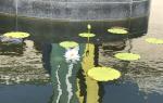
A scientific reserve has been created in the Volga delta. The abundance of sun and moisture, the extraordinary fertility of the soil create here exceptional conditions for the growth of the rarest varieties of southern plants. In the reserve you can see, for example, such a unique plant world as the lotus - the sacred flower of the ancient Egyptians. This is a very interesting marsh plant. It has large shield-shaped, waxy leaves and very large fragrant pink or pale cream flowers. They bloom only three days a year. Lotus in Europe blooms only in the Volga delta.
In former times, during winters, when a lot of snow fell in the Volga basin, and the spring was warm and friendly, a huge amount of water rolled into the Volga bed. Level rises in some high-water years reached 14-17 meters. This means that above the low horizon, the water in the river rose to the height of a four-story building! Then the river overflowed its banks, and its hollow waters overflowed for tens of kilometers, flooding coastal cities, villages, meadows, and arable lands.
“The Volga and Samara, spilling over an immense space, became agitated: huge brown swells rose on the surface of the water and tossed ships like chips... Houses, roofs, fences, various household utensils rushed in masses across the water...” - this is how one of the floods on the Volga was described.
But this happened only in some years. More often, there were periods when there was little water, and then the Volga became very shallow in the summer. Its shallowing in the second half of the last century became catastrophic.
S. Monastyrsky’s well-known guidebook at that time said: “The difficulties and sorrows of shipping... led to despair... From Rybinsk to Tver, shipping completely stopped... in some places, even near Yaroslavl and Kostroma, our mother Volga was forded... The shallowing of the Volga is chronic, it is unlikely Is it a reparable evil..."
This evil reached the point that the Volga was considered a dying river. The cover of the Alarm Clock magazine for 1885 depicts the following picture: a beautiful woman lies on her deathbed - this is Volga, and her daughters Oka and Kama are sobbing nearby in a kneeling position. The saddened stand at the dying bed History, Trade, Poetry. The doctor throws up his hands - I can’t help...
The magazine comments: “People standing close to the dying woman’s bed shake their heads in disgust: yes, they say, soon the feeding river will tell you to live long... A mighty hero, who gave hundreds of the most beautiful pages of our history, is dying...”
It was neither a cruel joke nor sharp satire. The magazine was not exaggerating. Bitter truth emanated from the words and the drawing. The shallowing of the Volga reached the point that large ships no longer sailed above Nizhny Novgorod. Shoals appeared in the most unexpected places, making navigation difficult or completely impossible. Dredging, which could help combat shoaling, was used on a small scale and irregularly.
To prevent catastrophic consequences, it was necessary to transform the Volga system.
A lot of work had to be spent to make the Volga what it is now.
The grandiose plan to transform the Volga was conceived within the framework of GOELRO - the first unified state plan for the electrification of Russia, developed in 1920. A large group of scientists and engineers worked on its creation. This plan received the strategic name “Big Volga”. It was complex in nature. This means that during its development the needs of shipping, irrigation, energy, water supply and much more were taken into account and provided for.
According to the project, the Volga was supposed to turn into a wide waterway, connect with the northern and southern seas, become a powerful factory of electrical energy and send part of its waters for irrigation in arid areas.
Such a grandiose plan for the transformation of the Volga basin could not be implemented in a short time, so it was divided into separate stages, which were put into practice.
In distant geological epochs, it so happened that nature “offended” the Volga, depriving it of access to the ocean, and forced it to flow into the inland sea.
This circumstance has long caused great inconvenience to the Russian people who communicated with other neighboring peoples. Merchants were especially dissatisfied, who were always attracted by the lively Black Sea market, where they could profitably sell their goods and buy foreign ones. For part of the journey, goods had to be transported overland, from one navigable river to another. Naturally, there were no cars then, and everything was transported on horses and oxen.
Thus, the need to connect the Volga with the Don is long overdue. This problem has occupied the minds of engineers and politicians for several centuries.
It is curious that the first attempt to connect the great rivers was made... by the Turks. This sounds like a historical paradox, but this is how it really happened.
Turkish Sultan Selim II decided to take away Astrakhan, annexed to the Muscovite kingdom in 1556, from Russia. To do this, he planned to transfer warships, heavy guns and troops by water - along the Don and Volga. In the place of the portage between the rivers, he ordered a dig to be made.
In 1568, a large army of the Sultan arrived in the interfluve area. The Turks immediately began digging a canal. However, it soon became clear that the task was impossible. Many people died from exhausting labor (the work was done manually) and hunger.
Having learned that uninvited guests were mastering Russian soil, Ivan the Terrible sent a large army to the place of work. But the Turks had fled from the inhospitable Russian soil even earlier. The ditch they dug in vain has survived to this day and is known as the Turkish Ditch.

Peter I also dealt with the problem of connecting the Volga and Don. “We decided to unite the main rivers of our empire into one body of water,” he wrote in 1709. “To unite” means to unite, tie together so that ships can easily pass from sea to river, from one river to another.
Peter I was a far-sighted statesman. He well understood how behind Europe at that time Russia was, with its long-established order, with its darkness and inertia. Peter improved existing and built new land roads and waterways. This made it possible to expand connections and trade with neighboring states.
The Volga was connected to the Don through Lake Ivankovskoye and the Upa River. But due to the political events of that time, the channel was not used, and therefore fell into disrepair.
In 1810, the construction of the Mariinsky system was completed - a waterway that connected the basins of the Volga and Neva rivers. It had 39 small wooden locks. Built with an ax and a shovel, the “Mariinsky Theater,” as this system was called, served faithfully
our people, but has long ceased to meet the requirements of modern shipping. All this old, dilapidated equipment needed to be replaced with new ones.
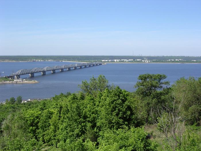
The Big Volga project began to be implemented from the moment the construction of the Moscow Canal began. It was necessary to immediately solve two important problems: to make the capital a large river port and to give it plenty of fresh drinking water. The canal was built in 1932-1937. Its length is 128 kilometers. About 200 structures were erected on this “man-made river” - 11 dams, 8 hydroelectric power stations, 5 pumping units. Many of them are decorated with bas-reliefs, statues, and frescoes. When you float along the canal, sometimes it seems as if you are in a museum of monumental sculpture. Traffic along the canal never stops. Cargo and passenger ships, barges, tugs pass along it in both directions, and many boats, yachts, and boats scurry about.
Then, in 1948-1952, the Volga was connected to the Don. The Volga-Don Canal arose here - a true miracle of engineering. It starts from the Volga near Volgograd and, crossing the Ergeninsky hills, approaches the Don at Kalach. The length of the route is 101 kilometers. There are 9 locks on the Volga slope, and 4 on the Don slope.
What did the Volga-Don give us?
It connected 30 thousand kilometers of navigable rivers of the Volga and Northwestern basins with 13 thousand kilometers of Don and Dnieper waterways. Tens of millions of tons of all kinds of cargo have already been transported along it. This is how the Volga gained access to the southern seas.
But for her this was far from enough. She desperately needed access to the northern seas - convenient and accessible for large modern ships.
Therefore, in the 50s and 60s, large-scale hydraulic engineering work was carried out to connect the Volga with the Baltic Sea. On the site of the outdated Mariinsky, a new large blue road Volgo-Balt - Volga-Baltic Waterway, about 1,100 kilometers long, was created. Instead of dilapidated small locks, new ones with several hydroelectric power stations were built here. In 1964, large cargo ships and passenger ships passed through it from the Volga to the Baltic for the first time.
For centuries, the mighty river wasted its heroic strength uselessly, wasting into the sea a huge mass of water collected by it in the vast expanses of our country. Meanwhile, it could have benefited people long ago.
In the past, many projects were proposed to create large hydroelectric power stations on the river, but none of them were actually implemented.

In the spring of 1937, near the village of Ivankovo, the Volga was blocked with a dam and forced to spill over the floodplain. Here the Moscow “Sea” arose, and the river began to rotate the turbines of the Ivankovskaya hydroelectric power station.
But this was only a modest beginning: after all, the power of the hydroelectric station is small - only 30 thousand kilowatts. After its launch, they began to build the Uglich and Rybinsk hydroelectric power stations. The first of them began to operate before the start of the Great Patriotic War, and in the days when Hitler’s hordes unsuccessfully tried to break through to Moscow, in November 1941, the Rybinsk hydroelectric power station produced current (330 thousand kilowatts).
When the country celebrated the victory over the black forces of fascism in May 1945, the water level in the reservoir rose to the projected height. And then, in place of a vast lowland, the Rybinsk “Sea” spread out.
Lower along the Volga, the dams should have been larger and higher, and the hydroelectric stations more powerful; This means that more labor, time and money had to be spent during construction. However, this no longer bothered the hydraulic builders. Having gained a lot of experience, they built one energy giant after another.
In 1950, the assault on the Volga began at Zhiguli. Quiet places, covered in the romance of ancient legends and glorified in the songs of the Russian people, came to life. Eight years later, the Volzhskaya hydroelectric power station with a capacity of 2.3 million kilowatts appeared here.
To obtain the amount of energy that the Volzhskaya HPP produces per year, ten thousand trains of coal need to be transported and burned in boilers. 40 thousand people are able to do such work.
The experience gained in the construction of large hydroelectric complexes made it possible to create a whole cascade of powerful hydroelectric power stations on the Volga.
The new “seas” turned the Volga into a wide waterway. Large ships travel along it from the northern seas to the southern ones. Thanks to the Volga reservoirs, it was possible to put an end to spills and floods. The “seas” absorb huge masses of hollow water, “cutting off” the peaks of high rises during the rapid melting of snow, so the Volga calmed down and stopped rampaging.
The Volga is the first of the greatest rivers on Earth, which is so fully and comprehensively put at the service of man.
The Volga is a river in the European part of Russia, one of the largest rivers on the globe and the largest in Europe. The length of the river is 3530 kilometers (before the construction of reservoirs - 3690 kilometers).
The Volga originates on the Valdai Hills at an altitude of 228 meters and flows into the Caspian Sea. The mouth lies 28 meters below sea level. During the year, about 250 cubic kilometers of water flows down the Volga, which is collected by 150 thousand rivers, streams and springs.
The area of the river basin is 1,360 thousand square kilometers, which is 8% of the territory of the Russian Federation. The source of the Volga is a spring near the village of Volgoverkhovye in the Tver region. The Volga is usually divided into three parts: the upper Volga - from the source to the mouth of the Oka, the middle Volga - from the confluence of the Oka to the mouth of the Kama, the lower Volga - from the confluence of the Kama to the Caspian Sea.
The Volga is mainly fed by snow (60% of the annual runoff), groundwater (30%) and rainwater (10%). The natural regime is characterized by spring floods (April-June), low water availability during the summer and winter low water periods and autumn rain floods (October). The annual fluctuations in the level of the Volga before the construction of the cascade of waterworks reached 11 meters at Tver, 15-17 meters below the Kama estuary and 3 meters at Astrakhan. With the construction of reservoirs, the Volga's flow was regulated, and level fluctuations decreased sharply.
The Volga opens near Astrakhan in mid-March, in the first half of April the opening occurs on the upper Volga and below Kamyshin, throughout the rest of the length - in mid-April. The river freezes in the upper and middle reaches at the end of November, in the lower reaches at the beginning of December; It remains ice-free for about 200 days, and about 260 days near Astrakhan.
Since the late 30s of the 20th century, the Volga began to be used as a source of hydropower. Currently, about 45% of industrial and approximately 50% of agricultural production in the Russian Federation is concentrated in the Volga basin. The Volga accounts for more than 20% of all fish caught in the country's rivers. 9 reservoirs with hydroelectric power stations were built on the river.
The Volga is connected to the Baltic Sea by the Volga-Baltic Waterway; with the White Sea - through the White Sea-Baltic Canal and the Severodvinsk system; with the Azov and Black Seas - through the Volga-Don Canal. An important role is played by the Moscow Canal, which connects the Volga with Moscow and was created for the purposes of navigation, water supply to the capital and water supply of the Moscow River.
According to experts, the load on the Volga’s water resources is 8 times higher than the Russian average.
Environmental problems of the Volga
Ecosystems in the river basin are 3-5 times higher than the national average. Of the 100 cities in the country with the most polluted atmosphere, 65 are located in the Volga basin. The volume of contaminated wastewater discharged into the region's basins is 38% of the total Russian total.
As stated in a World Bank study report prepared in 2008 on environmental protection activities in the Russian Federation, the Volga River is heavily polluted due to the discharge of industrial wastewater and the development of water protection zones.
Pollution of the Volga water affects river inhabitants - according to research data from 2007, the proportion of mutant fish in different parts of the river is about 90%. In 2008, the number of congenital deformities in certain populations of fry reached 100%. Samples of fish larvae revealed a change in the number of rays in the pectoral fin.
Blue-green algae also appeared in the Volga River. When decomposing, they actively absorb oxygen and release up to 300 types of organic substances - poisons. However, 200 types of these substances still remain unknown.
Every year, during the peak summer bloom, a film of blue-green algae covers about 20-30% of the surface of the Kuibyshev Reservoir. Dead algae, falling to the bottom, increase the content of phosphorus and nitrogen and create an ideal environment for their own self-reproduction. As a result, secondary pollution occurs.
The situation is complicated by the fact that, according to experts, after the construction of the dams, the Volga lost its ability to clean itself. In an interview with Russian Newsweek magazine, bottom sediment specialist Lyudmila Vykhristyuk said that the Volga reservoirs are practically non-flowing: 90% of the material entering them, including excess phosphorus and nitrogen, is not carried away by the current, but settles at the bottom.
The Volga basin, according to 2005 data, is polluted by about 2.4 thousand sunken and abandoned watercraft (including oil tankers, passenger ships, and cargo ships). The most critical situation, according to experts, has developed in Astrakhan - there are about 800 such vessels there. They pose a real danger to the ecology of the Volga and its tributaries, since they contain fuel residues that are washed away by the current. Some ships sank with cargo residues - often toxic chemicals that wash out over time and end up in the water.
According to the Volga Interregional Environmental Investigation Department of the Investigative Committee under the Prosecutor's Office of the Russian Federation, in 2008, environmental damage to the Volga exceeded 600 million rubles.
The material was prepared based on information from RIA Novosti and open sources
The Volga is one of the important rivers of the world. It carries its waters through the European part of Russia and flows into the Caspian Sea. The industrial importance of the river is great, 8 hydroelectric power stations were built on it, shipping and fishing are well developed. In the 1980s, a bridge was built across the Volga, which is considered the longest in Russia. Its total length from source to mouth is about 3,600 km. But due to the fact that it is not customary to take into account those places that belong to reservoirs, the official length of the Volga River is 3530 km. Among all the water streams in Europe, it is the longest. Large cities such as Volgograd and Kazan are located on it. That part of Russia that is adjacent to the central artery of the country is called the Volga region. The river basin covers a little more than 1 million km2. Volga occupies a third of the European part of the Russian Federation.
Briefly about the river
The Volga is fed by snow, groundwater and rainwater. It is characterized by spring floods and autumn floods, as well as low water content in summer and winter.
The source and mouth of which freeze and become covered with ice almost simultaneously, in October-November, and in March-April it begins to thaw.
Previously, back in ancient centuries, it was called Ra. Already in the Middle Ages, mentions of the Volga appeared under the name Itil. The current name of the water stream comes from a word in the Proto-Slavic language, which is translated into Russian as “moisture”. There are also other versions of the origin of the name Volga, but it is not yet possible to confirm or refute them.
Source of the Volga
The Volga, whose source originates in the Tver region, begins at an altitude of 230 m. In the village of Volgoverkhovye there are several springs that were combined into a reservoir. One of them is the beginning of the river. In its upper course it flows through small lakes, and after a few meters it passes through the Upper Volga lakes (Peno, Vselug, Volgo and Sterzh), currently combined into a reservoir.
A tiny swamp, which hardly attracts tourists with its appearance, is the source of the Volga. A map, even the most accurate one, will not have specific data about the beginning of the water flow.

Mouth of the Volga
The mouth of the Volga is the Caspian Sea. It is divided into hundreds of branches, due to which a wide delta is formed, the area of which is about 19,000 km 2. Due to the large amount of water resources, this area is the richest in plants and animals. The fact that the mouth of the river ranks first in the world in the number of sturgeons already speaks volumes. This river has sufficient influence on climatic conditions, which have a beneficial effect on flora and fauna, as well as on humans. The nature of this area is fascinating and helps to have a pleasant time. The best time to fish here is from April to November. The weather and the number of fish species will never allow you to return empty-handed.

Vegetable world
The following types of plants grow in the waters of the Volga:
- amphibians (susak, reed, cattail, lotus);
- aquatic submerged (naiad, hornwort, elodea, buttercup);
- aquatic with floating leaves (water lily, duckweed, pondweed, nut);
- algae (hari, cladophora, hara).
The largest number of plants is represented at the mouth of the Volga. The most common species are sedge, wormwood, pondweed, spurge, saltwort, and astragalus. Wormwood, sorrel, reed grass and bedstraw grow in large quantities in the meadows.
The delta of the river called the Volga, the source of which is also not particularly rich in plants, has 500 different species. Sedge, spurge, marshmallow, wormwood and mint are not uncommon here. You can find thickets of blackberries and reeds. Meadows grow on the banks of the water stream. The forest is located in stripes. The most common trees are willow, ash and poplar.

Animal world
The Volga is rich in fish. It is home to many aquatic animals that differ from each other in their mode of existence. In total there are about 70 species, of which 40 are commercial. One of the smallest fish in the pool is the tadpole, the length of which does not exceed 3 cm. It can even be confused with a tadpole. But the largest one is the beluga. Its dimensions can reach 4 m. It is a legendary fish: it can live up to 100 years and weigh more than 1 ton. The most important are roach, catfish, pike, sterlet, carp, pike perch, sturgeon, and bream. Such wealth not only provides products to nearby areas, but is also successfully exported to other countries.
Sterlet, pike, bream, carp, catfish, ruffe, perch, burbot, asp - all these fish representatives live in the inlet stream, and the Volga River is rightfully considered their permanent place of residence. The source, unfortunately, cannot boast of such rich diversity. In places where the water flow is calm and shallow, the southern stickleback lives - the only representative of sticklebacks. And in those areas where the Volga has the most vegetation, you can find carp, which prefers quiet waters. Sevruga, herring, sturgeon, lamprey, and beluga enter the river from the Caspian Sea. Since ancient times, the river has been considered the best for fishing.
You can also find frogs, birds, insects and snakes. Dalmatian pelicans, pheasants, egrets, swans and white-tailed eagles are very common on the banks. All these representatives are quite rare and are listed in the Red Book. There are many protected areas on the banks of the Volga, which help protect against extinction. Geese, ducks, teals and mallards nest here. Wild boars live here, and saigas live in the nearby steppes. Very often on the seashore you can find them quite freely located near the water.

The importance of the Volga for Russia
The Volga, whose source is in a village in the Tver region, flows throughout Russia. Through its waterway, the river connects with the Baltic, Azov, Black and White seas, as well as the Tikhvin and Vyshnevolotsk systems. In the Volga basin you can find large forests, as well as rich adjacent fields sown with various industrial and grain crops. The lands in these areas are fertile, which contributed to the development of gardening and melon growing. It should be clarified that in the Volga-Ural zone there are gas and oil deposits, and near Solikamsk and the Volga region there are salt deposits.
One cannot argue with the fact that the Volga has a long and rich history. She is a participant in many important political events. It also plays a huge economic role, being the main water artery of Russia, thereby uniting several regions into one. It is home to administrative and industrial centers and several millionaire cities. That is why this water stream is called the great Russian river.