Princess Juliana Airport, located on the island of Saint Martin. Low-flying planes on Maho Beach, photos and videos Low-flying planes over the beach
The island of Saint Martin (some use the name Sint Maarten) and its airport are located in the Caribbean Sea, which is one of the most popular tourist regions in the world. Almost every island that can be reached comfortably has development potential. There are two main ways to solve the delivery of passengers: ship or plane.
Sea and ocean cruises create a significantly smaller portion of the tourist flow compared to air transport. But the cost and complexity of air harbor infrastructure is significantly higher and sometimes requires non-standard solutions from engineers and architects.
The island of St. Martin in the Lesser Antilles archipelago has one of the most interesting airports in the world (ranked in the top 10 in terms of danger rating, according to Reuters). It also plays a major role in transport services to the surrounding areas: St. Eustatius, Saba, St. Barthelemy and Anguilla.
Princess Juliana Airport (full official name) has the ability to accommodate even large Boeing 747 class aircraft, although the runway, with a normal width of 45 m, is only 2300 m long, which is the maximum permissible value for some types of airliners. In this regard, takeoffs and landings taking place at a glide slope of 3° are considered the most dangerous in the Caribbean region.
The construction of the airport began with the construction of a military air base back in 1942. Although already in 1943, due to the lack of military operations in the region during the Second World War, it was converted into a civilian one. After 1964, it was reconstructed and a new control tower and terminal appeared. After 1985, it was modernized, so it began to be able to accept long-haul classes of aircraft and fully comply with the high development of tourism in Sint Maarten.
Features of the air harbor
Here we can talk about a variety of factors.
The island has a relatively small area - only 87 km², with predominantly hilly terrain and tropical thickets.
The island is divided by different states: the northern part is the French overseas community of Saint-Martin, the southern part is the autonomous entity of Sint Maarten, subordinate to the Dutch crown.
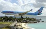
Only after 1994 was the Franco-Dutch protocol on border control signed. The end of the landing strip abuts Maho Beach in the west of the Dutch part. Airplanes land and take off directly above the heads of tourists, 10-20 m above the surface.
Spectacular photographs and videos of airplanes bring incredible popularity to Princess Juliana among other airports in the world. Nearby there are several cafes and hotels that specialize in the island's most famous species. A loudspeaker is installed on the beach, which reports about planes approaching to land and broadcasts conversations between dispatchers and crew.
In the central part of Maho, wind speeds can reach 180 km/h, which can be very dangerous and even fatal for humans, but this does not stop curious tourists who try to take vivid photos and shoot videos of the aircraft.
In 2012, renowned photographer Josef Heflener published black-and-white spotter photographs from the area around the airport, including them in the book Jetliner: The Complete Works.
Infrastructure
The location and topography of the island of Sint Maarten did not allow for the construction of a full-fledged runway. Therefore, it was decided to build a runway of the minimum allowable length for long-haul airliners (for example, 747). The width was increased to 45 m. Radar systems provide a range of up to 460 km. The capacity is thus up to 30 flights per hour.
The dispatch service also provides control over other small airports in this area: Clayton J. Lloyd, L’Espérance, Gustaf III. The terminal, with an area of 30,500 m², can serve up to 2,500,000 passengers per year. In the entire history of the airport, not a single accident has been recorded, although this runway is considered one of the most difficult for airliner crews and air traffic control services.
Photos and videos from Sint Maarten airport
View of the island of Sint Maarten
Princess Juliana Airport runway
The end of the landing strip abuts Maho Beach in the west of the Dutch part. Airplanes land and take off directly above the heads of tourists, 10-20 m above the surface.
There is an unusual airport, considered one of the most dangerous in the world..

Princess Juliana International Airport is located in the Dutch part of the island, and is unique in that its runway starts almost right next to Maho Beach, and since its length is not very long (only 2300 meters), all planes land very low altitude right above the beach.


Staring and taking breathtaking pictures of low-flying aircraft is perhaps one of the most popular activities among the many tourists who gather on Maho Beach during the arrival of aircraft. In many local bars and cafes you can see their arrival times.


But, despite such a harmless event from the outside as the landing of a liner, it can pose a real danger to people standing under it on the beach.


And the point is not even that the airliner can fall on people; by the way, in the entire history of the airport (it has been operating since 1942) there have never been such incidents here. The problem is the jet streams from landing and taking off airliners, which can blow you into the water. The authorities constantly warn about this - in addition to the barbed wire on the fence, adopted for those who want to sit on it, many corresponding shields are placed along the beaches.


In the entire history of the airport, there have been only 3 incidents here, two of them in the vicinity of the early 80s of the last century, and one at the airport itself quite recently - on January 14, 2014.


In 1970, a McDonnell Douglas DC-9 passenger plane flying to Sint Maarten from the United States, after several unsuccessful attempts to land at the airport in bad weather, made an emergency landing directly into the Caribbean Sea. 22 of the 57 passengers and one crew member were killed. It turned out that the airliner ran out of fuel due to several attempts to land the plane, and most of the people died due to the fact that they were not informed by the crew about the upcoming hard landing on water, because of which they did not prepare and did not fasten their seat belts.


The second crash occurred on December 21, 1972 with a small twenty-seater De Havilland Canada DHC-6 Twin Otter aircraft. It crashed at night in the ocean near Saint Martin on its way from Guadeloupe, killing all 11 passengers on board along with the two pilots.


And the third incident occurred a couple of days ago, when a Boenig-747 of the Dutch airline KLM, en route to a parking lot after landing on time, made a left turn instead of a right - because of it, at least 17 cars parked nearby were damaged by its jet stream. They had broken windows and damaged paintwork, but no injuries were reported.
Yesterday we discussed with mib55 difficulty of landing, however, there are a dozen airports where landing conditions are also difficult and specific. It is clear that the airports in these places were designed not for beauty and spotters, but as much as possible in the conditions of the natural environment, in order to at least pull something out and connect with air traffic... But not only the pilots have to maneuver and follow all the rules of a difficult landing, I think the passengers of these flights You will also have an unforgettable experience of taking off and landing in such places.
1. Princess Juliana Airport, Holland
Operating airlines: almost all US airlines, French charter carrier Corsairfly, KLM airline.
Princess Juliana Airport is located on the island of San Maarten, which is part of the Dutch Antilles in the Caribbean Sea. The airport's runway is very short (its length is 2130 meters) and therefore planes are forced to land literally a hundred meters from Maho Beach, where tourists sunbathe. An additional thrill is given by the knowledge that the airport is not equipped with an automatic landing system, so the planes land under manual control. The runway almost ends at a group of beach restaurants. Planes must land as close to the start of the runway as possible due to its short length, so they land at such minimum altitudes that they appear to brush the heads of people on the beach. You can peacefully lie on the beach, but when a Boeing 747 flies a few tens of meters above the ground, a real sandstorm arises due to the air flow created, which easily scatters things around. There is also some special fun here. Tourists are trying to stay on the beach when the plane taxis to the net off the coast and starts to take off from there, the jet from the engines hits the tourists and tries to knock them into the water) People come here for thrills, not for sunbathing, and all conditions have been created for this - in All bars and restaurants nearby have flight schedules. As if that weren't enough, a loudspeaker on the roof of the Sunset Beach Bar broadcasts conversations between air traffic controllers and pilots of planes about to land.
This is a spotter's Mecca. It is difficult to believe the authenticity of the photographs of giant airliners flying at an altitude of 10-20 meters above sunbathing tourists, however, they are real. Despite the difficult take-off and landing conditions, not a single accident has been recorded at this airport.


2. Kai Tak - Kulun, Hong Kong
Airlines operating the flights: Cathay Pacific, Dragonair, Air Hong Kong cargo airlines and Hong Kong Airways
Due to the location of the airport, surrounded by high hills and close to the water, as well as the presence of residential buildings in its immediate vicinity, KaiTak airport went down in history as one of the most terrible, and the landing of airliners at this airport looked very spectacular due to its extreme nature. The airport was closed in 1998.


3. Paro, Bhutan
Operating airlines: Druk Air, local carrier
Paro Airport is located at an altitude of 2,225 meters above sea level and is surrounded by Himalayan peaks over 4,000 meters high, making take-off and landing extremely challenging.
Before leveling the plane for landing and landing it on the airport pad, the pilot performs several unconventional maneuvers in a narrow corridor of mountain peaks.


4. North Front, Gibraltar
Airlines operating: British Airways, EasyJet, Iberia Airlines and Monarch Airline
The airport is located on a tiny peninsula with an area of 6.8 square kilometers. The lack of space on this peninsula is catastrophic, so the airport's only runway crosses the busiest highway, Winston Churchill Avenue, leading to the land border with Spain. When planes land or take off from runways, traffic on the highway is interrupted by barriers and traffic lights, similar to what happens at railroad crossings. This situation arose due to the tiny size of Gibraltar, which consists of a southern rocky part and a northern flat part - a sand spit connecting the rock with the Spanish coast. The airport runway is located on the flat part of Gibraltar, crossing it across and dividing its territory into two unequal sections. These two sections are connected by a single highway, which is forced to cross the airport runway.


5. Mariscal Sucre - Quito, Ecuador
Through the glass wall of the airport building you can see planes landing. The airport in the capital of Ecuador is one of the most difficult airports for pilots in Latin America. There is a very tight runway here, which is based practically between several active volcanoes.

6. Barra - Outer Hebrides, Scotland
Airlines operating flights: British Airways and Flybe (England).
The only airport in the world located on a beach and with regular flights. The operating hours depend on the ebb and flow of the tides. The airport itself is just a very shallow bay. Therefore, landing and takeoff here are only possible during low tide. The rest of the time, the runway is covered with water. Three sand strips are equipped on the island for take-off and landing of iron birds. By the way, the airport is not suitable for all winged guests, but only for aircraft with short takeoff and landing characteristics


7. Matekane Air Strip, Lesotho
It's not just the landings that are difficult. In the tiny African kingdom of Lesotho, the 416-meter-long runway is located on the edge of a gorge at an altitude of 2,303 meters, so the plane 'drops' about 600 meters before taking off. . According to the pilots, there is a possibility that, having reached the end of the site, the plane will not leave the ground. The rule of flying in the mountains is as follows - it is better to take off with the wind and downhill than against the wind and uphill.

8. Funchal - Madeira, Portugal
The runway of this airport is located on a cliff.
Madeira International Airport is located on the island of the same name in Portugal. Despite its civilized appearance, it is located in a very nerve-wracking place - between the rocks and the ocean. The runway is built on 180 pillars with a diameter of 3 m, some of which rise 50 m above sea level.


9. Toncontin, Tegucigalpa, Honduras
Airlines flying: American Airlines, Continental, Copa Airlines, TACA, Islena Airlines and Aerolineas Sosa.
Pilots have a saying, “A landing you can get away with is a good landing.” This strange statement makes sense when it comes to Toncontin Airport in Honduras. The location next to a mountain range, the runway being too short, and the difficulty of the approach make the airport one of the most dangerous in the world.

10. Tenzinga and Hillary, Nepal
Operating airlines: Nepal Airlines, Yeti Airlines, Sita Air, Gorkha Airlines, Agni Air. Flights operate only from Kathmandu
The airport runway is only 527 meters long and is located at a slope of 12% at 2860 meters above sea level in a rock gorge (nearby mountain peaks are almost 5 km high), while pilots do not have the opportunity to go around, but there is the need to dive with the nose below before landing so as not to hit the mountains. . Due to the large slope, the ends of the runway differ in height by 60 meters. Flights here are only possible during the day and subject to good visibility. The weather around the airport is unpredictable, and its instability causes frequent flight cancellations. The airport allows only helicopters and short take-off and landing planes. The airport is in demand among climbers intending to conquer Everest and starting from the city of Lukla.

11. Juancho Airport (Juancho E. Yrausquin), Saba Island in the Caribbean Sea
A dangerous airstrip at the very edge of Saba Island.
Juancho Airport occupies quite a large part of the small island of Saba. Some experts are of the opinion that the airport is one of the most dangerous in the world, despite the fact that no accidents have occurred here. There is an X on each side of the runway, indicating that the airport is closed to commercial aviation. Landing at the airport, located on the peninsula, pilots must cope with strong winds and sea spray. In addition, the length of the landing strip is only 396.5 meters.
The location of the airport poses a threat. On one side there are high mountains, and on the other - the sea and steep cliffs. The danger is that the plane may go off the runway when landing or taking off.

12. Airport named after. R. Reagan, Washington, USA
The airport has an unenviable location in close proximity to strategically important US national security installations. We are talking about the White House, the Pentagon buildings and the headquarters of the CIA. Thus, the airport is located between two no-fly zones, requiring pilots to exercise great skill to stay away from strategically important objects. When taking off, the plane must gain altitude as quickly as possible and turn sharply to the left in order to avoid flying over the White House.


13. Courchevel - Alps, France
The airport was included in the Guinness Book of Records due to its “hunchbacked” and unusually short runway. Its length is 525 meters, and the slope is 18.5%. You have to approach and take off on a slope to set the required speed. This is the airport shown at the beginning of the movie Tomorrow Never Dies. For others, the only way to get here is by private planes, helicopters, and charter flights. Pilots undergo extensive training to land at the CVF.

14. Maui, Hawaii
Aerial view of the airport runway on the coast of Maui. Fortunately, this is not the main airport in Hawaii.

15. Kranebitten - Innsbruck, Austria
The airstrip is in the mountains and surrounded by houses. 
16. Male (Maldives)
The Maldives archipelago, consisting of twenty-six islands, is surrounded by the Indian Ocean, and Male Airport (officially called Ibrahim Nasir International Airport) is located on the island of Hulhule. The airport begins and ends with water. When landing, a picturesque view of this island and most of the archipelago opens up. The airport was built by 2,250 local volunteers in the 1960s.


17. Corfu
Airlines: Olympic Airways, Aegean Airways
18. Eilat (Israel).
The airport is located right in the city, planes fly not over the beach, but over the road and buildings. The spectacle is certainly not usual, to put it mildly, it is fascinating. 
19. London City (London, UK)
As the closest airport to central London, the views on approach to London City Airport are spectacular with iconic landmarks including Big Ben, the London Eye and the Olympic Park. The approach to this airport is also unique due to its steep landing glide slope of 5.8 degrees, compared to 3 degrees at conventional airports.

20. Jackson Hole (Wyoming, USA)
Here the landing takes place against the backdrop of the Teton Mountains, and the airport itself is completely surrounded by the picturesque landscapes of Grand Teton National Park. That's why Jackson Hole Airport became a US National Monument in 1940. According to PrivateFly respondents, the approach to this airport is especially beautiful during sunset.

21. Airport on the island of Aruba (Dutch Caribbean)
Queen Beatrix International Airport is the gateway to the Caribbean island of Aruba. Landing over the ocean on the strip located on the west coast of the island gives a stunning view of the island. Originally there was an American airbase at this airfield. An international airport opened here in the 1950s. Passengers upon landing can fully see the entire island from coast to coast.

22. St. Barts (French Caribbean)
Airport named after Gustav III has a runway just 650 meters long and is located on the Caribbean island of Sant Barthelemy. Only the most highly qualified pilots can fly to this island. One even compared St. Barts to “landing on an aircraft carrier.” An additional difficulty is represented by the hilly terrain, difficult wind conditions, and the need to land at a sharp angle. Large international aircraft cannot be accommodated at this airport; to get to this Caribbean island, you must rent a propeller plane from a local charter line.

23. Queenstown Airport (New Zealand)
Located on the South Island of New Zealand. Landing here gives you the opportunity to see the entire island from a bird's eye view, enjoying the famous landscapes of New Zealand, including views of Lake Wakatipu, the Southern Alps, and the Remarkables mountain range. This airport is especially popular in winter: ski lovers from all over the world come here. “The plane descends very smoothly, at low altitude; it feels like you’re flying a few centimeters away from the skiers on the mountain slopes.”

24. Narvik Airport (Norway)
This is one of the northernmost airports in the world. Located above the Arctic Circle, in the northern part of Norway. It was built in 1972 and was originally used as a military airfield. On approaching the airport, a stunning view of the winter landscape opens up: “This is a spectacle of the real Arctic - mountains, lakes and fjords.”

There is a beach in Phuket where planes land right above your head :) This beach is located next to Phuket airport, some believe that it is part of Mai Khao beach, someone claims that it is also , I think that planes land between these two beaches and to avoid confusion, this part of the coastline is simply called – :)
The beach with airplanes in Phuket is where planes land right above your head!
Of course, we couldn’t help but go to this part of the island to photograph the planes flying overhead. The beach with the planes is quite far from our condo in Phuket, about 35 km! Therefore, we decided to go to the beach with planes as early as possible in the morning, so that the road would be easier, otherwise it would be very unpleasant to ride a bike in the heat during the day, but you still need a car to get around Phuket!
With what difficulty we managed to wake up at 7 in the morning and leave the house before 8 is a hotel story :) But I will say that we didn’t get to this beach with airplanes the first time. I’ll digress a little from the topic, but I’ll write anyway. The first time, waking up early in the morning and going out into the yard to get on the bike and rush off to the beach, we were surprised to discover that one of our helmets had been stolen from our bike! How did it happen? This is the first time I encountered this! Not only is the helmet old and worth a penny, who would need it? Also, we seem to have a guarded complex: guards sit at the entrance/entrance to the condo territory, and constantly walk around the territory, and there are cameras hanging. In general, an incomprehensible situation... It’s not a pity to have a helmet, it’s just unpleasant that you can’t easily leave anything on the bike or on the territory. Otherwise, I could leave the phone on the table near the pool and swim calmly, without looking around. That morning, instead of the beach with the planes, we had to go to the Tesco store and buy a new helmet. Of course, that day we had already decided not to go that far, but went to another, nearby beach.
A day later we had to get up again at 7 am, this time we had already safely reached the beach with the planes :) Now I’ll tell you about it in detail.

Beach with airplanes in Phuket: review and impressions
Airplane Beach is located at the confluence of Phuket's two northern beaches: Nai Yang and Mai Khao. Despite the fact that these beaches are very long, the beach strip itself, from where you can watch and take photos of planes taking off and landing, is small. And the part where everyone wants to take a photo under a flying plane that is generally 100-150 meters long, so at the peak of the influx of tourists, crowds form here and taking good photos without strangers in the frame becomes problematic.
 In the morning the beach is almost empty
  Part of the beach near the airport
 We arrived at the beach with planes at 9 am and, despite the early morning, there were already people here who wanted to take photos, most likely they were guests of a neighboring hotel.
 It’s early morning, and tourists are already waiting for planes :)
  Families with small children came for a photo shoot
  And we are waiting for the plane, and while it is not there we take a photo against the backdrop of the sea
 Around 10 am, planes landed quite often, but then there was a short break and we went on vacation further north to Mai Khao Beach, and then further south to Nai Yang Beach, from where you can also watch planes landing over Phuket :)
 We observe planes north of the airport from Mai Khao beach
  Watching from Mai Khao Beach
  View of a landing plane from Nai Yang Beach
 In order to take beautiful photos with planes landing over the sea and the beach, you need to plan so that there is the “correct” wind on that day and the planes land from the sea, because... Planes do not always land on this side. We were lucky with the wind and landing :) But all the planes, except one, took off that day in the opposite direction from the sea.
 Only when the wind is in the “correct” direction can planes land from the sea
  That day, when we were on the beach, before lunch only one plane took off towards the sea, the rest took off in the other direction
 Photos with airplanes turn out to be interesting, but already looking at these photos at home, I understand that I should have photographed from a longer distance and from below. Many professional photographers come to this beach to shoot photo sessions, you need to see from them what angles they take pictures from :) I saw cool photos on the Internet where a girl scratches the “tummy” of an airplane, we didn’t get such photos... Frankly, standing over a flying plane There was a plane flying over my head, I was a little scared... And after the plane flies, a strong wind rises and sand flies into my eyes, blowing things away, so be careful! I lost my favorite earring on this beach; it was impossible to find it in the sand :)
 I'm looking for the plane: it's far away there - still a very small dot
  And here he is! 🙂
  In this photo I had to stand where the girl was sitting and take the photo from below
 About the beach itself
Now a few words about the beach itself, or more precisely about that part of the beach that is next to the airport. The sand here is very coarse and yellow, I don’t like that kind of sand. The water in the sea is clear, in the high season the sea is calm, from April to October there are waves in this part of the island.
The beach is quite dirty, there are mountains of garbage everywhere, and a small river flows into the sea. There is no shade in the center of the beach, in the place where everyone is waiting for planes, but to the north, next to the hotel, there is a causarine grove where you can hide from the scorching sun. Despite the absence of palm trees, this part of the beach with airplanes for some reason reminded me of.
 The beach is wide, the sand is coarse, yellow
  There is no vegetation in the part of the beach where planes land. But to the north the casuarina grove begins
  This gorgeous casuarina grove
  In the northern part a river will flow into the sea
  The sea water is clean and transparent
  But there’s a mountain of garbage nearby on the shore :)
 Beach near Splash Beach Resort by Langham Hospitality Group
  Beach near Splash Beach Resort by Langham Hospitality Group
  The same beach in April. From April to October there are strong waves on the beach with airplanes
 Where is it and how to get to the beach with planes in Phuket
The beach with airplanes Phuket is located in the north-west of the island, one might say almost at the exit from Phuket to the mainland. Beach coordinates with airplanes: 8.111991, 98.301942
The distance from the popular Patong Beach to the beach with airplanes is just over 40 km. A taxi will cost 900-1000 baht one way. But I know that on social networks they offer a Russian taxi for 1,400 baht round trip with an hour wait on the beach.
From Phuket Town to the beach with airplanes is 35 km. You can take the Airport Bus to the airport, go to Nai Yang Beach and walk along it to the place where planes land. Airport Bus departs from the old bus terminal in Phuket Town (coordinates: 7.884055,98.395671) from 6 am to 6:30 pm approximately every hour. The fare is 100 baht.
We rode the bike from our condo to Katha for over an hour. Traffic jams on Phuket roads are still bad!
How to get to the beach with airplanes
Well, now the most important thing: how to get to the beach with planes, where to leave the transport, so that you don’t have to walk very far along the seashore.
Before going to the beach, I tried in vain to find the answer to this question. Everyone wrote somehow vaguely: the landmark hotel Splash Beach Resort by Langham Hospitality Group to the north or the Maya Phuket Hotel to the south of the airport. Someone even suggested leaving the vehicle in the airport parking lot and then walking! Below I will tell you how to get as close as possible to the point that is indicated on Google maps as Aeroport view point.
We drive from the south/centre of Phuket, pass the airport and almost immediately turn left onto road 3033, there will also be a sign for Mai Khao Temple. We drive until we hit a T-junction with a 7-year-old store on the corner. Then there are two options. One option is not very correct, but I will write about it anyway.
Option 1
From 7 eleven we turn left, pass the turn to the water park and at the next turn right and almost reach the hotel. You can try to leave your vehicle in the hotel parking lot and walk through the hotel, or there is a road with a barrier nearby (coordinates: 8.116090, 98.306177), sometimes a guard sits there. He didn’t want to let us in, so we left the bike nearby and walked. But, as I understand from the reviews, there is a security guard in this place, sometimes not. If there is no one, then you can safely drive under the barrier and drive along the road to the sea. And there are literally a few steps and the desired beach.
 If you go straight, you will end up in the hotel parking lot. The best option is to turn onto the road under this barrier and drive to the end of the road straight to the sea. But sometimes a formidable guard stands here and doesn’t let you in :)
  There are several cafes and shops near the entrance
 Option 2
At the intersection where there are 7 streets, turn right, and then turn left into one of the streets. For example here: 8.123953, 98.308099 and get to point 8.120987, 98.302011 near the Coriacea Boutique Resort hotel. You will have to leave the car here, and then walk along the path along the sea past the villas of the Splash Beach Resort by Langham Hospitality Group to the place where the planes land.
 We turn into this lane and go to the sea
  After the road reaches the beach, you can ride a bike onto this pedestrian path along the sea and drive all the way, you can’t drive a car!
  We drive along the villas. I’ll be honest, it was unpleasant to drive, it seemed like you were driving through private territory :)
  And here comes the sea. We park the bike nearby and walk literally 50 meters to the beach where planes land
  Plenty of parking space
 Option 3
The enterprising Thais organized a large parking lot (coordinates: 8.127668, 98.301308) and launched a tuk-tuk from it and some nearby hotels to the place where you can watch the landing planes! Prices in the photo:
 Prices for tuk-tuk from the nearest hotels to the beach with planes
  Knock-knock to the beach with airplanes
 If we talk about access to the beach from the south side of the airport, from Nai Yang Beach, then it is advised to leave your transport near the Maya Phuket Hotel and then walk. Nearby is the entrance to the Sirinat National Park, the entrance to which is paid - 200 baht per person! (I don’t understand why? It’s still dirty there!). And then walk along the seashore to the point where planes land far away. I am this way I don't recommend it.
- Lately, information has been popping up more and more often on the Internet that the beach with airplanes is closed! Beach not closed, it cannot be closed :)
- The landing direction of aircraft depends on wind directions: During the low season from April to October, planes mostly land not from the sea side, but from the land side! Airplane landing directions can be tracked on the flightradar website
- I advise you to come to the beach where planes land as soon as possible! The best time is from 7 to 10 am
- On the beach where everyone is waiting for the planes no shadow, the day is very, very hot. Sunscreen, light long sleeves, a hat and you can wait for takeoff and landing :)
- Here the sun sets into the sea, so it’s good in the evening at sunset, but photos of airplanes will also turn out against the sun
- Take water/food with you to the beach; there are no cafes or other infrastructure on the seashore
- If someone, like me, needs a fresh shower after the sea: there is a shower at the entrance from the beach to the Splash Beach Resort hotel
 Even in the morning it is very hot on Mai Khao beach. Waiting for planes in the shade of trees :)
 Photo


Spotting is the name given to photographing aircraft landing at close range. In Phuket, the beach with airplanes is a real attraction. People come there not to swim, but to capture impressions and take unusual photographs. On the map this beach is marked as Nai Yang. Very close to Mai Khao Beach. I didn’t see any special marks or designations where one beach ends and another begins.
How to get to the beach with planes in Phuket
You need to go towards Phuket airport. You don’t need to get to the airport itself; it’s better to follow the signs to Sirinath National Park and park your car there, and then walk along the sea in the shade to the beach with the airplanes.
Taxi cost 1000 baht one way. Plan to visit the beach for several hours. If you wake up late, the whole daylight hours will go away.
Is the beach with planes worth 2000 baht and a whole day? It's up to you to decide. We spent a wonderful day full of impressions, walked around Sirinath Park, saw enough planes, and saw a piece of another Phuket. But it was not possible to take super photos. The weather was gloomy. Good for walking, but not so good for photographs. Well, we are not such professionals as to catch amazing shots at once.

Well, we tried :))
Maxim and I walked to the beach along the sea from the Sirinat National Park. Everyone usually scolds him, saying there’s nothing to do there. We liked.
When planes land on the beach
If you have the time and desire to see a slightly different Phuket, head to the beach with planes early, right in the early morning. There are many people who want to photograph themselves against the backdrop of an airplane. Chinese, Europeans, Russians, families, couples, large groups, with small children - there are so many spotting lovers here! At the height of the day, you will need to try very hard to get a good shot!
They say there are gaps in the plane schedule. You can sit waiting for two hours and not catch a single plane. We were lucky, the landings came one after another.


Beach safety with planes in Phuket
The runway is literally a few meters from the beach. There are barriers, but it’s still better to take care of safety yourself.
When the plane takes off, the turbines create a wave of hot air. It literally knocks you off your feet and covers your eyes and nose if you stand with your back to the sea, facing the plane. It is better at this moment to sit on the ground and cover the child with a towel. Hats, panama hats and caps fly away just like that! Either put them away or hold them with your hands.

And this plane is getting ready to take off
But you can watch landing planes from any angle, even standing, lying down, or jumping. It's fun!