Afrikanda Murmansk. Afrikanda - We will turn earthly life upside down
For anyone who is even slightly sensitive to words, the name "Afrikanda" on the map of the Kola Peninsula causes cognitive dissonance. Because, of course, there is only one association - with Africa, and what the hell is Africa in the Arctic?!
So I marveled at such strangeness for several years, and then finally got ready and drove.
Getting there is always helpful. And not only because it is better to see once. But also because when you are going to go, you begin to delve into fart. Anyway, I understand. And it’s good that I penetrated in advance, otherwise I would not have understood anything at all.
For starters, there were two Afrikands. And actually even more.

But first I’ll tell you about the name, because all the same, the origin of the name is of interest to everyone much more than the quantity and quality of all Afrikands combined.
As for the name, there is such a version among the people that one of the founders of the village - either geologists, or railway workers, or builders - worked in the heat, and one said: “Africa!”, And the other confirmed: “Yeah ... ".
This bike was clearly launched by someone completely unfamiliar with local names. The toponym "Kanda" is often found in Kola, and its presence in the word immediately suggests the alteration of some primordially local name. And right. The lip on Lake Imandra, next to the current Afrikanda, is called Ohta-Kanda.
And now let's look at what A.E. Fersman in the book "Remembrance of the Stone", 1958
“Geochemists have found a remarkable deposit near the junction No. 68. They say that the world's titanium ores have been discovered here, hundreds of millions of tons on one small hill. Well, that means they will build a plant, a factory, a settlement.
Even embarrassing: the world's ores, and the siding is just number 68. This is how the old railwayman thinks. "We need to rename it. Yes, these mineralogists will laugh again, you will call them by a word, and they will call you by this word! I don’t know. Yes, and it’s hot today, it’s not up to christening. You should go for a swim in Imandra, otherwise it’s unbearable, the dispatcher is still stuck here: go to Okhtokanda, take some kind of barracks, slander business, and in such heat! Well, just Africa, some kind of Afrikanda!"
The junction was named Afrikanda...
By God, I told everything about the birth of the word correctly.
True, he embellished a little, but, as they say, everything is tentatively correct.
So at first there was still Okhta-Kanda. After being changed into Afrikanda, either really from the heat, or from the well-known habit of topographers to reduce unfamiliar and incomprehensible words to familiar ones.
Since 1925 there was a railway station at which the settlement began to grow. Here is the station.

Not a single living soul was found either outside or inside.

Afrikanda-1 grew up on the soil of a military airfield, its territory is visible on the map, it has its own rich history.
They write that while the airfield was alive, Afrikanda-1 flourished. The regiment based there was elite, housing was being built, there were rich military stores and other infrastructure, life was in full swing. It boiled until 2001, when the air regiment was disbanded and transferred to Murmansk, and everything acquired, as usual with us, was abandoned.
Today the road to the airfield is locked, the castle is easily bypassed from the side, but we didn’t cross the airfield on foot. In front of the gate there is a colorful and almost fresh soldier's bathhouse.


The once prosperous village looks not just uninhabited, but eerily uninhabited. Although there is smoke coming from the chimney of the boiler room, signs of life are visible in a couple of houses and there are quite decent cars nearby.


Even the garages near the railway station look more life-affirming.

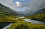
The civil history of Afrikanda began in 1949 with the construction of a plant for the enrichment of titanium-containing ores. The plant worked until 1991. They write that now part of the plant is used for the production of crushed stone and there is security on the territory. We saw only titanic ruins, the grandeur of which is exacerbated by the location in a beautiful place on the banks of the Imandra.
This thing is visible from the road, it is located between Afrikanda-1 and Afrikanda-2.
Afrikanda-2 was built as a settlement for the workers of the processing plant and also has the local name Promstroy or simply Prom. In 1991, when the factory was closed, there were no jobs for the residents of the village. The population naturally began to decline.
Population |
|||||
|---|---|---|---|---|---|
But, oddly enough, Afrikanda-2, unlike Afrikanda-1, does not at all give the impression of a dead village. On the contrary, she looks not only alive, but very pretty.
They write that in the old days, the civilian Afrikanda (No. 2) envied the military (No. 1), where both the shops were better and there was more movement. It's hard to believe now. Afrikanda-2 looks almost like the city of my dreams - charming two-story houses with balconies and bay windows, freely located among the pines. It was very well built.
There was even discovered, quite unexpectedly, the Children's Art School.
And near the House of Culture, a large folk festival was unfolding in honor of - not Easter, they didn’t guess, but seeing off winter - with children's attractions and barbecues.
And the barbecue, by the way, was very tasty.
I don’t know how it was at other times, but on the Bright Sunday of Christ, Afrikanda-2 looked exceptionally attractive.
P.S. The inhabitants of Afrikanda-2 support the African flavor.
| |||||


Military town at the eponymous airfield and railway station, not far from the city of Polyarnye Zori, Murmansk region.
It was founded in 1937 after the discovery of a titanium ore deposit. During the war years, a military airfield was located on the territory of the village, where various aviation units were based. Often Afrikanda became the object of secret operations. The airfield was also used to refuel/repair allied aircraft heading deep into the USSR.
In the post-war years, Afrikanda did not lose its military status, aviation units continued to be based at the airfield, in Afrikanda in 1953 a new airfield was built with a class 2 BVPP (one of the first in the Arctic). The 431st Fighter Aviation Regiment, which was part of the air defense, "settled" at the African airfield. For the garrison, many rather comfortable one- and two-story houses were built for those times. Gradually, the aviation regiment acquired infrastructure, grew rich, and five-story houses appeared - first brick, then block, built a school, a kindergarten, an officer's club.
Four kilometers from the military Afrikanda, they began to build a civilian village engaged in the extraction of titanium ore. In everyday life, they were called like this: military - Afrikanda-2 (because it is further from the city, although older), civilian - at number 1. When the Leningrad Institute "Mekhanobr" came to Afrikanda in the 1970s, which worked with ores, a very stormy life began.
In 1991, Mekhanobr closed and moved out. In 1993, the 431st Fighter Aviation Regiment was disbanded and at its base, as well as the 641st Fighter Aviation Regiment transferred from Rogachevo (Novaya Zemlya), a new 470th Guards Vilna Order of Kutuzov Fighter Aviation Regiment was formed on the Su-27 (aircraft transferred from Novaya Zemlya, personnel - partly from the same place, partly from the former 431st Fighter Aviation Regiment .
In 2001, the 470th Guards Vilna Order of Kutuzov Fighter Aviation Regiment was also disbanded, the aircraft were transferred to the 941st Fighter Aviation Regiment in Kilp-Yavre, which was then reorganized into the 9th Guards Fighter Aviation Regiment. After that, the Ministry of Defense decided to reduce the airbase and transfer the regiment near Murmansk, to the town of Kilpyavr. At the moment, most of the village is abandoned, the resettlement of the remaining residents continues.
The old building of Afrikanda-2 dates back to the 50s. These houses are 90% unusable. The rafters there are wooden, the ceilings too, everything has long rotted away. Plus (or rather, minus) - polar conditions, permafrost. Here, in June, the earth thaws on the bayonet of a shovel, so all local vegetable gardens are practically bulk, and the trees have a superficial root system.
This article is about the locality. For the airfield, see the article Afrikanda (aerodrome).afrikanda - village in the Murmansk region. Included in the urban district of the city of Polyarnye Zori. Population 1908 inhabitants (2002). It consists of 2 parts: Afrikanda-1 (military camp) and Afrikanda-2. Founded at the railway station, which appeared in December 1925. In the village there is the eponymous airfield of the fighter aviation regiment disbanded in 2001, which covered the 6th army missile brigade. The village has a secondary school, a kindergarten, a hospital, a cultural center.
Near the military camp there is a working settlement Afrikanda-2 - a settlement at the processing plant, which is currently closed. First of all, former factory workers live in it, as well as families of employees of the Kola Nuclear Power Plant, located in the city of Polyarnye Zori. The village has a school, a kindergarten, a post office and a branch of Sberbank.
Houses in Afrikanda
A regular bus and fixed-route taxi runs between Afrikanda and Polyarnye Zory. There is also an electric train to Kandalaksha and Apatity.
The name of the station appeared in the conversation of the railway engineers who designed the line. On an unusually hot day, they joked: "It's hot, like in Africa" and half-jokingly called the future station Afrikanda, which later stuck in the name.
From 1935 to 2004 it had the status of an urban-type settlement.
Notes
- ^ A. V. Superanskaya. Social theory of proper name. - Mtr.: Nauka, 1973. - Page 86
- Site dedicated to the history of the village; photo
afrikanda| Neck | Polar dawns
Categories:
- Settlements in alphabetical order
- Settlements established in 1925
- Settlements of the urban district of the city of Polyarnye Zori
- Former urban-type settlements of the Murmansk region
- Articles about settlements without a category in the 24map directory
- Reference book on the geography of the Murmansk region