Mount Großglockner, Austria. Grossglockner Alpine Road The highest mountain in Austria Grossglockner height
The Großglockner High Alpine Road has been closed for winter since 4 November 2019.
The Großglockner High Alpine Road is not an ordinary utility road connecting two neighboring regions in Austria. For faster travel there is the A10 motorway.
The panoramic Großglockner High Alpine Road is one of the most famous mountain roads in the world. It attracts tourists from many countries with an annual visitation of approximately 900,000 people, making it one of the most visited places in Austria.
The Großglockner High Alpine Road is part of Austria's cultural history, one of its major tourist attractions and a world-renowned feat of construction.
a brief description of
The road is closed at night - .
Location
The Grossglockner High Road is part of the 107 Austrian regional road and is located in the center of the Austrian Alps (Google Maps, Google Earth).
The distance from Salzburg is about 100 km, from Innsbruck - 120 km, from Munich - 200 km. Given the excellent quality of Austrian highways, it will take about 1.5 - 2.5 hours to get there from these cities.
The Großglockner road connects the states of Salzburg and Carinthia. Passes through the Hohe Tauern National Park. In addition, it leads to the Kaiser Franz Joseph Center, with panoramic views of the Pasterze Glacier and the Grossglockner Mountain.
How to get to Großglockner High Alpine Road
From Salzburg:
Exit the A10/E55 motorway at the Graz/Villach sign and follow it towards Italy until Bischofshofen (38 km).

Then turn at the sign Bischofshofen/Pongau onto regional road 311 and follow it until the exit for Bruck/Fusch (44 km).

After this, take road 107 and after 23 km you will reach the northern entrance to the Großglockner High Alpine Road.

The total distance is 105 km, travel time is 1.5 hours.
From Bolzano (Italy):
Take the A22/E45 motorway and follow it towards Austria until Bressanone (45 km).
Exit the motorway onto the regional road SS49/E66 and continue to the Austrian town of Lienz (100 km).
After Lienz you enter regional road 107 and after 43 km you reach the southern entrance to the Großglockner High Alpine Road.
The total distance is 190 km, travel time is 3 hours.
Road
A little history
The first mention of it dates back to the autumn of 1924, when a project for a gravel road three meters wide, with the possibility of expanding to five meters, was developed.
On August 30, 1930 at 9:30 am the first rock explosion was carried out. In the first year, mainly survey work was carried out.

Thirteen months later, on September 22, 1934, the first driver crossed the Hohe Tauern in a Steyr 100 (1.2 l, 32 hp, 100 km/h top speed, consumption of about 10 liters of gasoline per 100 km).
The Großglockner High Alpine Road was officially opened on August 3, 1935 and in its first year it attracted 375,000 visitors and 98,000 vehicles.
Fare
The price includes not only the toll, but also access to all Großglockner information resources, as well as use of all parking areas, including the garage in the Kaiser Franz Joseph Center.
Tariffs for 2019:1 In case of entry after 18:00, the ticket price is reduced to € 26.50 for cars and to € 20.00 for motorcycles.
2 sightseeing tickets are valid for one month for travel on the Großglockner High Alpine Road and Felbertauern Road.
3 return journeys on the same day are free.
A repeat visit in the same calendar year with the same car or motorcycle (with the same number plates) will cost € 12.00 (old ticket must be presented).
Working hours
The road is open to travel from May to October or November during the daytime. The exact opening and closing data of the road is determined based on weather conditions.
- From the beginning of May to May 31: 6:00 - 20:00
- From June 1 to August 31: 5:00 - 21:30
- From September 1 to October 26: 6:00 - 19:30
- From October 27 to early November: 8:00 - 17:00
The last visitors are admitted 45 minutes before closing.
WEB camera
Image from a web camera installed next to Fuscher Lacke:

Description of the road
The Großglockner high mountain road passes through the heart of the Hohe Tauern National Park. It is 48 km long, including 36 sharp turns ( "a la hairpin") and rises to a height of 2,504 meters.
1. Northern entrance
2. Gate Fuscher Törl(2,428 m) - the monument was designed by the world famous architect Clemens Holzmeister. It is dedicated to the workers who died during the construction of the road. This place is one of the best points for photography.
3. Fuscher Lacke(2,262 m) - The exhibition "Building of the Road" impressively presents the interesting history of the construction of the Großglockner High Alpine road.
4. Hochtor(2,504 m) - the highest point of the road and the border between the states of Salzburg and Carinthia. On the north side there is usually snow until the end of August.
5. Turn to the Pasterze Glacier and the Kaiser Franz Joseph Tourist Center.
6. Kaiser Franz Joseph Center(2,369 m) - view of the Grossglockner mountain and the Pasterze glacier.
7. Southern entrance onto the Großglockner High Alpine Road.
In the video below you can see a small section of the Großglockner High Alpine Road to get an idea of what to expect (you can watch other videos on our channel at YouTube).
Along the entire road there are a large number of special panoramic recreation areas. Here you can fully enjoy the surrounding views, relax and take wonderful photos as a souvenir.
Attractions
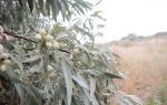
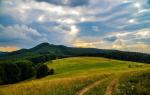
In fact, the main attraction is the road itself and the views that open from it. Along the route, you will find flowering meadows, fragrant forests, mighty rocks and eternal ice at the foot of Mount Großglockner.
Kaiser Franz Joseph Center
The center is located at the foot of the Großglockner mountain and overlooks the longest glacier in the eastern Alps - Pasterze.
The center is a 4-story building in which visitors are shown everything that is most interesting about the highest mountain in Austria - Großglockner.
There are a large number of parking spaces near the center. But it’s better to drive to the end of the road and park in a multi-story garage. Moreover, it is best to go onto the roof of the garage.

This way you will be closer to the Kaiser Franz Josef Center itself. And after you’ve examined everything you wanted, you’ll be able to quickly get to the car and move on. In addition, from above there is a wonderful view of the glacier itself.
More information about the Großglockner High Alpine Road on the official website - www.grossglockner.at
Impressions from the road
Despite the fact that reference information is published on the site, it is difficult to resist telling about your impressions.
Did we enjoy the trip along this road? Definitely yes. The road is well worth visiting, despite the rather high price of travel. Moreover, both the surrounding views and the process of moving along the road with its sharp turns, descents and ascents deserve attention.
And at the Kaiser Franz Joseph Center it is very pleasant to walk in the mountains and recharge with positive emotions while enjoying the surroundings.
There are a lot of motorcyclists on the road who constantly rush past you. And you even come across instances like this.

And the number of cyclists climbing this mountain is simply amazing. Only here do you begin to realize how truly popular cycling is in Europe.
It so happened that in a short period of time we managed to visit two mountain roads - Großglockner and Timmelsjoch. And comparisons between them could not be avoided. Here you can see a description of the Timmelsjoch high mountain road.
In conclusion, a few photos with views of what opens right from the road.


I dreamed of preparing today’s post for a very long time, since it will talk about the most beautiful place of our entire trip. I really like alpine mountain passes. Firstly, the roads are laid in very beautiful places, and secondly, the Europeans made sure that tourists here were as comfortable as possible. The Austrians are not at all behind Switzerland in this regard. Today I will tell you about one of the most picturesque mountain routes in Austria - the Grossglockner panoramic road. Welcome to Austria!
Immediately after Verona we headed to the Austrian town of Lienz, which is located very close to the Grossglockner road. To be honest, it turned out a little crumpled due to the long distance (300 km) and the late departure from Verona. We had to cover part of the route in the dark: we hardly saw Lienz and the Dolomites. We spent the night in a small country hotel on the outskirts of Lienz.

How nice it is to wake up early in the morning, leave the hotel and breathe in the cold mountain air. This is an indescribable feeling!


Europeans tend to get up very early, especially in rural areas.

The village where we spent the night is called Lavant. There is a parish church of St. Ulrich, located on the mountain:

We didn’t go up there, but here’s a photo of the interior of the church from Wiki, isn’t it cool?
Michael Kranewitter via Wikimedia Commons
Someone left several cases of beer cooling in the fountain opposite the hotel entrance:


Starting from Lienz, the road smoothly rises into the mountains and passes through the most beautiful places with an abundance of observation platforms.


The Grossglockner panoramic road itself starts from the town of Heiligenblut, 40 km from Lienz.


The road got its name in honor of the highest mountain in Austria - Grossglockner, whose height is 3798 m. Here it first appears in view (snow-capped peak):

The Grossglockner road is not an ordinary road for utilitarian purposes, rather it is a tourist attraction. For faster travel, use the A10 expressway.


The panoramic road is a serpentine of 36 turns, about 48 km long. At the very beginning of the road it has a small branch that leads to the Pasterze Glacier and the Kaiser Franz Joseph Center. There is the maximum approach point to Grossglockner.
Image from websitewww.grossglockner.at
Well, here we are finally on the road itself. Some historical facts: it was put into operation in 1935. However, when in 1924 a group of Austrian experts presented a plan to build a road through the Hochtor Pass, it was met with skepticism. At that time, in Austria, Germany and Italy there were only 154 thousand private cars, 92 thousand motorcycles, and 2000 km of asphalt roads. Austria suffered catastrophic economic losses in the First World War, reduced its size sevenfold, lost its international markets, and suffered crippling inflation.

Even a simple 3 meter wide gravel road project with passing lanes proved to be too expensive. The impetus for the construction of the road, which would open the barren Alpine valley to motorized tourism, came from a downturn in the New York stock market in 1929. This disaster greatly shook poor Austria. Within three years, production fell by a quarter. Then the government revived the Grossglockner project in order to give jobs to 3,200 (out of 520 thousand!) unemployed. In the new project, the road was widened to 6 meters, counting on 120 thousand visitors per year. The state decided to cover construction costs by introducing tolls for road use.

On August 30, 1930, at 9:30 am, the first rock explosion was carried out. Four years later, the head of the Salzburg government drove along the new road for the first time. A year later, the Grossglockner high mountain road was put into operation. And the very next day the international automobile and motorcycle races Grossglockner Races were held on it.

Construction costs turned out to be less than planned, and attendance in the first years significantly exceeded the most optimistic estimates. Subsequently, a phased modernization of the road was carried out. Its width and the number of parking lots, located in the most picturesque places, increased.


From the first day of operation, travel on the road was paid. Now the fare averages 20-50 euros, depending on the validity of the ticket and the type of transport. A standard 1-day passenger car ticket costs 32 euros.


The road is open to tourists from May to October. In winter, the passage is closed because the snowfall often exceeds 10 meters.

Here is a short video taken on the way to the Kaiser Franz Joseph Center. By the way, it was filmed just a few days before we visited there:
Around the next turn there is a magnificent view of the glacier and the Grossglockner peak. The Pasterze Glacier is the largest in Austria, its length is about 9 km.

The melting of the glacier began as early as 1856 due to high summer temperatures and low winter precipitation.


Despite record summer temperatures in Europe, scientists from the Swiss Academy of Natural Sciences attribute the melting of glaciers to long-term climate changes.


Find two tourists in this photo:

A branch of the road eventually leads to the Kaiser Franz Joseph Center. In addition to the standard tourist infrastructure (restaurants, tourist center), you can find several exhibitions here, for example, the Grossglockner Glacier and Peak Museum. There is even a museum of automobile history, although I could not find information about it on the Internet. Apparently this is a temporary exhibition. In general, the Grossglockner road attracts owners of vintage cars from all over Europe, but more on that later.

This place is visited by a huge number of tourists, so there are several spacious parking lots, including one multi-level one.


The overwhelming number of tourists are pensioners. They sit on the veranda of the restaurant, bask in the sun and have lunch. Happy old age!

Grossglockner was first conquered in 1800. The first attempt to climb was made a year earlier, but failed due to bad weather. A day after the first ascent, a wooden cross was placed on the summit. In 1879 it was renovated and dedicated to the 25th anniversary of the marriage of Emperor Franz Joseph I and Empress Elisabeth, who visited Grossglockner in 1865.

The name Glocknerer first appeared on maps in 1561. Grossglockner first described in his book Balthasar Ake: naturalist, geologist, geographer, doctor, scientist, who is considered a pioneer of mountaineering. Interestingly, until 1918 the mountain was privately owned. Currently, Grossglockner belongs to the Austrian Alpine Community.

When you zoom in as far as possible on the previous photo, you can see how a large group of climbers is currently conquering the peak. I noticed this quite by accident when I was preparing a post. Now there are about 5,000 ascents of Grossglockner annually.

To be continued in the next post.
Materials used in preparing this post.
22.07.2017
Grossglockner Hochalpenstraße
Großglockner high mountain road– this is the most beautiful panoramic road in Austria and probably one of the most beautiful in Europe, it is visited by more than 1 million tourists a year.

The road begins in the federal state of Salzburg in a village in a town Fusch an der Grossglocknerstrasse(Fusch an der Großglocknerstraße), and ends in Carinthia in a pastoral postcard town Heiligenblut(Heiligendlut), or vice versa, depending on where you start the journey from)))


This is the very heart of Austrian Alps: highest mountain, largest glacier Pasterze, the most beautiful village Heiligenblut, the most beautiful panoramas and all this is located in the largest national park Hohe Tauern. If you are planning to travel around Austria in the warm season, be sure to stop by here. You will be guaranteed a lot of bright impressions.
- the length of the road is 48 kilometers,
- the highest place on the panoramic road - perval Hokhtor (Hohtor) , 2504 m.
- the road passes by the top of the mountain , actually named after her alpine highway and it is the highest in Austria.
- On panoramic highway 36 turns are stated, but in reality there are much more of them; only the largest and steepest ones are marked.
- maximum road gradient is about 12%

On the road from Carinthia there are two exits from the main road: one leads to Kaiser Franz Joseph Center, and further to the observation deck on the Pastertse glacier, from here there is a cable car that can go straight down to the glacier, or you can also use the steep stairs. If you have time, take a walk to the glacier; it has been melting for more than 120 years, but the spectacle is breathtaking. But we do not recommend traveling on the glacier itself without an experienced guide: there are many deep crevices under the fragile ice. This is the largest glacier in Austria - 9 km long, a huge colossus of ice, snow, mud and stones, descending into the valley.


The second, less known, but very spectacular exit leads to the observation deck on the mountain Edelweissspitze, 2573 m. Many drivers do not dare to climb it, it is steep but absolutely passable, as a reward you will have a view of 37 three-thousanders and, it seems, 18 glaciers. Just to see this place is worth coming to Grossglockner.
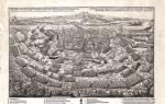
Route and map of the Grossglockner High Alpine Road 

There are many places on the road for panoramic photography of all the surrounding alpine beauty, with convenient parking, diagrams of where you are and what is around you, and even information centers.

Without any effort at all, you can photograph mountain goats and marmots (these are, in general, symbols of Grossglockner); they are not afraid here and willingly expose themselves to camera lenses. There are even playgrounds for children.

Prices for proad trip
- 35 euros for a car,
- 25 euros for a motorcycle

The road does not operate all year round, but from May to October; there are no exact opening and closing dates, it all depends on the snow cover. In winter, the road is covered with snowdrifts up to 10 meters high, in recent years this has happened rarely, but nevertheless, we once drove up the road to a part that had not been cleared of snow and in front of us stood a snow wall the size of a two-story house, it is very impressive how and a photo of how this wealth begins to be raked in the spring, now this is done by large snow removal equipment, and in the first years of the road’s operation 300 strong Austrian men climbed the mountains with shovels! It took about a month to clean it...

So it’s best, plus in the summer there are more chances to really see all the surrounding beauty, and not clouds with rain.
The operating time of the Grossglockner high mountain road is from May to October.
- May until June 15: 6:00 — 20:00
- June 16 - September 15: 5:00 — 21:30
- September 16 to October: 6:00 — 19:30
The last tourist is allowed onto the road 45 minutes before closing.
History of the high mountain road:
Construction of the road began in 1930, exactly one year later! (can you imagine such deadlines for our builders?!!) it was solemnly opened, a few days later a rally was already held here. Now this road is very popular among cyclists and motorcyclists. Sometimes it’s very scary to be on sharp turns at the same time as them. And in the summer there are sooooo many of them.

The road was conceived back in the 20s of the 20th century, but was not built, because they did not believe in the technical feasibility of implementing such a complex project, but in the 30s, Austria was tormented by the crisis after the First World War and in order to provide work for 3,000 people, the Austrian government allocated a budget for the construction of a high-mountain highway. It was built in a year and spent less money than planned (can you imagine this in our realities?).
On the second day after the opening, the Grossglockner Races for cars and motorcycles were held here; they continued here until the Second World War. And now owners of all kinds of rare cars regularly organize races and trips here. Status bike races also take place here.

Initially, the road was intended to be a toll road, and from the first days there was more traffic on it than expected. Until the 50s, the road was used as a regular highway, but with the opening roads A10 the main flow of cars “on business” took a detour along a flat road, and tourists began to use the Grossglockner serpentine even more actively.
In 2016, the Grossglockner panoramic road was submitted as a candidate for inclusion in the UNESCO World Heritage List.

A small lyrical digression. You can skip ahead to the next two paragraphs if you want.
Once upon a time, when I first got behind the wheel, I was wildly afraid and did not feel at all confident in the driver’s seat. However, I was fabulously lucky with an instructor who had truly angelic patience and “rolled” me out. Yes, it rolled out so much that after nine months of driving experience, I ended up on Lago-Naki in a car with a ground clearance of 13 cm (without taking into account protection). And this was in those days when this road was “suitable only for off-road vehicles.” It's a pity that we found out about this after the fact. However, we successfully got to the top and went down! I didn’t ruin the car, they themselves remained unharmed, but after 10 hours of driving I got wet to the point of my underwear and called myself bad names five hundred times for my arrogance. But the “long” weekend spent like this was a great success, we gained impressions, delight and had an absolutely magical rest! And they became incurably sick with a passion for mountains and mountain roads. Sanka, thank you! I still love you and am immensely grateful! You gave me the chance to make my most cherished dreams come true.
So, I must say that I was lucky not only with the instructor, but also with my husband. Seeing how attached I am to the steering wheel and my cars, not only has he not even once in all these years even tried (!) to get behind the wheel on all our trips (I don’t know how he manages to do this - I definitely wouldn’t be able to!) . But every year he even tries to find and offer me some wonderful mountain road as a decoration for the route. “Everything is there just as you like!” - he says. This means that the road will have crazy hairpin turns, elevation changes and mind-blowing views. Moreover, the more terrible the road, the more often it is mentioned in all sorts of ratings “the most dangerous roads..., the most difficult roads..., the most beautiful mountain roads... etc.,” the better. And the stronger I will be in my desire for her. So the road to Lysefjord in Norway appeared on my personal list of conquered roads, and last year the Stelvio Pass was on our route - . And that’s how the Grossglockner Alpine Road was added to our route this year. Thank you, gladchenko !! You are my knight and my hero!
Now let's return to Austria.
After Hallstatt, in which we admired the clouds, the lake, got cold before dawn, and then got fried during the day on the way to the parking lot, our path lay in the town of Fusch an der Großglocknerstraße. This is the commune where our cherished alpine road begins. It was decided to spend the night there in order to go early in the morning to admire the views - so we planned to catch my favorite clouds in the morning and find enough time for stops and oohs and aahs.

Our path lay in the middle of beautiful landscapes, surrounded by mountains and waterfalls.


As you can see, we arrived in the evening and in the drizzling rain. These drops on the windshield made me nervous - I really didn’t want to drive along the most beautiful Alpine road in Austria in the rain.

Our Chalet Charlotte turned out to be exactly as wonderful as we dreamed. The hostess greeted us as if she were her beloved relatives, the communication was so informal, warm and lively that the feeling of awkwardness and fatigue from the road were instantly erased and disappeared. On her advice, we went to a local restaurant for dinner, where they served venison. We tried it for the first time in our lives, the impressions were the most favorable. And from the waiter, and from the dishes, and from the surroundings.
Just in case, we once again consulted about the schedule of access to the road - for safety reasons the road is closed at night, we inquired about the price and received some practical advice. Well, we heard a lot of compliments and delight - and how great we are for getting here by car, and how lucky we are that we are going to admire such beauty, and how smart we are, how well and relaxed we speak English. Flattery is shorter. Rude. But nice ;)
They also reassured us about the weather. They say it’s always like this here. “Tomorrow everything will be fine, there will be sun. You'll see!"
And we saw!

The morning, which began with the singing of birds outside the window and the purest, moist fresh air in the room, continued with the entrance to the toll section of Grossglocknerstrasse. Entry costs between approximately 20 and 34 euros. Along with the payment receipt, we received this sticker on the windshield and a couple of booklets that described in detail, with diagrams and maps, the entire range of pleasures available to us along the route.

The menu included magnificent mountains - about thirty “three-thousanders”, many viewing platforms, attractions with feeding of a local attraction - marmots, and other joys of a spectacular mountain road.

Along the way, we constantly came across pockets like these - here you can stop, admire the views and get acquainted with the diagram, which shows all the visible peaks and all the beauties that we still have to meet along the way (map from the site www.grossglockner.at).


As you can see, we got a lot of clouds. It’s an unimaginable feeling to ride in the clouds, burst into them and emerge, stand above them, deeply breathing in the completely boundless, endless space and intoxicating freedom.


And no one... Only the huge bells on the necks of seemingly tiny cows jingle loudly in the distance.

The clouds, flowing in white foam along the blue-green velvet slopes, slowly rose, gathered into marshmallow mountains and floated towards the horizon, revealing absolutely stunning views.


In the haze far below you could see rivers, little men and houses - like hobbit holes.


The road was not particularly difficult - with a width of 6, and in some places 7.5 meters, driving along it was not very difficult. You have time to look around without yawning in stiletto heels. But you still need to be vigilant. The turns are sharp, the elevation difference is good. So yes, everything is as I like. According to the maps there are 36 hairpins. In fact there are more of them. 36 are the most tricky ones. They are all marked with signs with their numbers, heights and names - one (the 11th, I think) is called “Witch’s Kitchen”, for example.

Once upon a time, this road was built simply to give work to three thousand unemployed people in difficult times. In 1930, construction of the road began, laying it through the Hohe Tauern. And a year later the road was opened, and the day after the opening the first automobile and motorcycle races took place along it. Subsequently, the flow of people wishing to enjoy the beauty increased many times over, so the road was modified, expanded and equipped with extensive tourist infrastructure designed for guests of different age groups, preferences and abilities.

It has no transport significance. If you need to quickly get from point A to point B, then there is the A10 highway. And Grossglocknerstrasse is precisely a view road. The whole thing is a tourist attraction. From the smallest pebble to the Pasterze glacier.

One of the symbols of the entire park of Hohe Tauern and Grossglocknerstrasse is the Alpine marmots - they are everywhere there. A couple of times balls of piercingly squeaking thick furry butts tried to roll down from the mountains under our wheels, but we never had a chance to look at them. Only once was it possible to observe them, and even then from a great height. Wow, do you see a mink and a plump ball of fur next to each other on the rocky soil? Tourists feed marmots, so the animals are not at all afraid of people.

The route runs from the entrance to the road through intermediate passes and peaks to the glacier and the large Kaiser Franz Joseph tourist center next to it. The glacier is slowly melting, and the chances of seeing it are becoming less and less every year. It’s all the more disappointing that I don’t have a single travel photo left. The glacier was completely covered with clouds, and it was extremely cold there - after +34°C in Hallstatt it would be +4 °C on the glacier it was very invigorating.
From the glacier the road leads us down through several more tourist spots to the commune of Heiligenblut. It is impossible to drive along the road for a long time without stopping - the views are absolutely stunning. You can admire both the flora and the unique local fauna. In the next photo, on the shore of a reddish-rusty small lake, a herd of mountain goats is seen grazing. Wow, they can be seen on the stone as yellowish spots.


A riot of greenery, flowers, the brightest sky, snow-white peaks in the distance - beauty!

It is better to drive in a lower gear - especially downhill. The slope is constant and quite noticeable. The brakes have a hard time.
By the way, somewhere I came across advice along the lines of “If you are not used to mountain serpentines, do not irritate local drivers with slow, stupid driving, take a paid excursion by bus or by car with a guide.” I completely disagree! Firstly, personally, on such a road, neither slow nor fast drivers cause me the slightest irritation. There's no time for that. And the surrounding greatness of nature sweeps away all irritability, discontent and intolerance from the soul. Slowly riding, careful old men touch you, enthusiastic young people on motorcycles cause a smile and a little anxiety - “Don’t get killed!” And on any such road, drivers actually turn into a kind of brotherhood of initiates. "We did it! Really, beauty?!” - can be read in every glance, accompanied by sincere smiles and affection. So don't listen to anyone. If you love it, go and enjoy it!
And here it is Heiligenblut and its main attraction - Gothic Church of St. Vincent.

According to legend, the Danish knight Bricius brought here a religious shrine - the Blood of Christ. According to the same legend, on his way home he was caught in an avalanche, which buried him. And he was found by three ears of corn that had sprouted over his body. This legend was even reflected in the coat of arms of Heiligenblut (taken
Cow traffic jams. Mountain roads Gerlos and Großglockner. Krimml waterfalls. The highest mountain peak in Austria and the Pasterze glacier.
Around Austria by car. Innsbruck - Krimml - Flattach. Grossglockner high mountain road. Krimml waterfalls.
This is the case when watching is better than reading. On the sixth day of the trip we begin a full immersion in the Alps. Today is devoid of urban tourism, but full of beautiful mountain landscapes, waterfalls and amazing alpine roads. The main star of today is the famous Grossglockner high mountain road. Yes, and the waterfalls near the town of Krimml turned out to be quite good. Follow our journey and subscribe to our YouTube channel, as well as to the email newsletter of our blog (column on the right or at the bottom of the page).
Route map and accommodation.
The entire route of this day passes along mountain roads. Moving along them is leisurely, but fascinating, all you have to do is turn your head. The total length of the route Innsbruck-Krieml-Grossglockner-Flattach is about 280 kilometers, including branches to the Edelweisspitze and to the Pasterze glacier.
Accommodation: Apartments Appartementhaus Mentil, Igls, suburb of Innsbruck. Booking via Booking.com. One night - 84 € (the most expensive accommodation on the trip). Breakfast is not provided. Free parking . Attention! On the booking the price is indicated less (45€) than it actually is, since there is an additional note in small print about the cleaning fee.
Almabtrib holiday and traffic problems associated with it.
So I came to leave hospitable Innsbruck and our luxurious Waldhaus Igls apartments. We leave them in their original form and order.

We pass through the outskirts of Innsbruck, drive a little along the autobahn, then turn towards Zell am Ziller, then a little more and find ourselves on the road leading towards the town of Gerlos and the toll mountain road of the same name.
At the entrance to Gerlos we begin to come across processions of dressed up cows and shepherds.

Each procession completely occupies one of the lanes of the road, forcing cars to stop and wait for it to pass. The first couple of times it looks interesting and funny, we are even glad that we got to some traditional event and have the opportunity to enjoy the national Austrian flavor. The shepherds are cheerful and wave at you in greeting.

But at some point it begins to tire, because time is running out. But the worst thing happened in the city of Gerlos itself. Here we got stuck in a traffic jam for almost an hour.

Moreover, interestingly, for a long time there were no cows, then two not very large processions passed, but we continued to stand dead.

But it turned out that at this time the traditional Almabtrieb holiday takes place. This is the name of the event dedicated to the return of cows from high alpine pastures home, held in late September or early October. If the grazing season has been successful, the cows are dressed up and proudly march down. The shepherds are also all dressed up, many are drinking beer and are already a little tipsy.

Another danger is the uncontrolled movements of cows. For example, one of the cows hit our car with a bell on its neck. And these bells - wow, they are not small at all. Thank God, there were no serious consequences.
Around 12-30 we finally set off and it turned out that the traffic jam in Gerlos was caused not only and not so much by cows, but by people (tourists) who had already begun to celebrate the holiday with might and main. And beer and schnapps. The people were having fun and walking, wandering along the road as if they were at home. Therefore, the traffic was alternately one-way and at low speed.
Having escaped into operational space, we began to enjoy the alpine landscapes. The weather was magnificent, as was the case for the next few days of our stay in Austria. So lucky, so lucky. Soon a very beautiful lake appeared on our way.

We assumed that it was also called Gerlos.

However, during the preparation of this report it turned out that its name is Speicher Durlassboden. In general, this beauty quickly began to banish the negativity from wasting a lot of time in a traffic jam.

Soon we passed the toll point for the Gerlos mountain road (9€) and headed to our first point today - the cascade of Krimml waterfalls. The road is beautiful, but not very exciting. As you approach the waterfall, you can stop at the observation deck just opposite the last one. From here there are good views of the valley.

And, in fact, to the waterfalls themselves.

A little closer.

Another observation point is already at the entrance to the Krimml.


We finally reach the city, there are several parking lots, we stopped at P3, which seems to be the closest to the park entrance. We were lucky, there was one place. True, for a long time we could not figure out how to pay, until Anya went to the cafe opposite and gave 5 € in cash. I don’t even remember if they gave us any kind of check.
From the parking lot you need to go under the road bridge and walk along the path for 10-15 minutes, pay for the entrance (3€ per person) and now we find ourselves at the site of the lower waterfall.

It’s already very beautiful here, the water falls on the stones with all its might, raising a column of spray.


The climb is quite steep, but there are constant opportunities to catch your breath, as views of the waterfall appear along the entire route.

Here we are already approaching the middle of the road. It must be said that this cascade of waterfalls is one of the highest in Europe, the total height is about 385 meters.

Double cascade.

The path to the very top cascade, judging by the sign, takes an hour and fifteen minutes. The halfway point is 40 minutes.

The views are of course stunning and the waterfall is very impressive.

Now we have reached the middle point. There is a restaurant and a huge stone here, and you can also access the Krimml-Ache River, which creates the waterfalls. The river here is calm. Peaceful landscape.

It turned out that my trekking boots were dirty from a previous trip (I don’t remember where), so I decided to take the opportunity and washed them right in the river.

We were very happy and took selfies.


We decided not to climb to the very top, since the time was already approaching 15 o’clock, and we wanted to get to the Grossglockner track in bright light of day. On the descent we turned into one of the branches that we passed during the ascent.

Eh, what a blunder!

An attempt to photograph a rainbow, which is formed by the reflection of the sun in splashes of water.

At 15:36 we leave Krimml and, slowly winding through the mountain valleys, at 16:48 we reach the Großglockner road toll point. The cost for a passenger car for the whole day is 35 €. With this ticket you can leave the road and return any number of times, but only within this day. By the way, the last entry in the autumn period is possible at 18-45. The road itself closes at 19-30.
Well, what can I say about the road? We will not go into the history of construction and other technical facts. Let's just enjoy this truly amazing and stunningly beautiful high mountain trail. We managed to fly a drone here for a bit and got such wonderful views.
In this photo below you can see the Haus Alpine Naturschau museum, altitude 2260 meters.

This is the northern section of the road, viewed from the south.

The turret is the Fuscher Torl lookout point. Fuscher Lake is visible to the left.

Here you can see the restaurant complex in front of a separate branch of the Edelweisspitze road.

First, we unknowingly drove past the branch to the Edelweisspitze and ended up on the Fuscher Torl, altitude 2428 meters. Look how beautifully and neatly everything is arranged.

The evening sun creates magical lighting.

Anya saw edelweiss, which, unfortunately, had already dried out. But I'm not 100% sure if it's him. Write if anyone knows.

There are stunning mountain panoramas everywhere you look.

At these altitudes, things are actively moving towards winter, the grass is already quite withered, but it’s still beautiful.


Edelweisspitze
The highest point of the Grossglockner route, accessible to cars and motorcycles, is the Edelweisspitze peak, height 2571 meters. Here you need to climb along a narrow serpentine paved with paving stones. The road is breathtaking in places.

Here we are at the top.

The parking lot is small and even at this time of year and day there are quite a lot of cars here. I can't imagine what happens during high season.

A souvenir shop with an observation deck on the roof.

As at all viewpoints along the road, you can have a snack here.

Northern slope of the Grossglockner road. Almost in the center you can see a branch, from here we launched our quadcopter for the first time.

Here we see Fuscher Torl and how the road goes around the hill.

Fuscher Lake. As it is written in the travel booklet, here you can walk around the lake. But, to be honest, this puddle did not impress us at all.


One of the sharp serpentine turns on the Edelweissspitze.

Hochtor Pass
And the highest point of the main road is the Hochtor pass, height 2504 meters. The views here are also good, but not as impressive.

The main adventure at the pass where we stopped was meeting cute sheep.

Anya did not miss the opportunity to feed them.

They ate the bread with great pleasure. In this photo, although it’s bad, the Hochtor sign is visible in the background - the only photographic evidence of our stay here :)

Another beauty. The sheep were really cute. When it was time for us to continue our journey, they did not want to let us go for a long time and chased us all the way to the car. The parting was sad...

Glacier Pasterze
It was getting dark and twilight was rapidly falling. Of course, we regretted that we had not come here earlier. We really missed that very hour lost in Gerlos. With some risk, we still went to the Kaiser-Franz-Josefs tourist center (2369 meters) - the last point of our stay on Großglockner. We arrived here at 18:45, there were almost no people there.

It is from here that you can see the highest peak in Austria - Mount Großglockner, which gives the name to the road. The height of the mountain is 3798 meters. In the photo below, it is the highest peak on the left. And from here you can observe the longest glacier in the Austrian Alps - Pasterze.

The length of the glacier now reaches 9 kilometers. Over the past 100 years, the glacier has melted very much; only its small tail is visible from the tourist center, but once it filled the entire gorge.

In the daytime, it is suggested to go down directly to the glacier (its remains); now we could only admire the views.


This ended our stay on the Großglockner road. Exactly at 19-00 we left the glacier and already at 19-13 we left the Großglockner highway. At 20-00 we reached the town of Flattach, where another cozy apartment was waiting for us. We booked them for 45€, but it turned out that there was a cleaning fee in the fine print, so we ended up having to fork out 84€! As a result, this accommodation turned out to be the most expensive for us. This is the only negative (albeit a serious one). Otherwise, the apartments were very good; unfortunately, we didn’t take any photos of them, but they are on video. We also really liked the hostess, originally from Sweden, she was very positive and showed sincere interest and attention to us.
That's all for today! Subscribe to our accounts (YouTube, VK and email newsletter - all in the right column) and follow our blog updates!
Previously :
In contact with