The Himalayas are the highest mountains on Earth. The Himalayas are the largest mountain range in the world.
The Himalayas are the highest mountain range in the world. It stretches for approximately 2,400 km in a northwest-southeast direction and has a width of 400 km in the west to 150 km in the east.
Solarshakti / flickr.com View of the snowy Himalayas (Saurabh Kumar_ / flickr.com) Great Himalayas - view on the way to Leh from Delhi (Karunakar Rayker / flickr.com) You will have to cross this bridge if you are going to Everest Base Camp (ilker ender / flickr.com) Greater Himalayas (Christopher Michel / flickr.com) Christopher Michel / flickr.com Christopher Michel / flickr.com Sunset on Everest (旅者河童 / flickr.com) Himalayas - from a plane (Partha S. Sahana / flickr.com) Lukla Airport, Patan, Kathmandu. (Chris Marquardt / flickr.com) Valley of Flowers, Himalayas (Alosh Bennett / flickr.com) Himalayan Landscape (Jan / flickr.com) Ganges Bridge (Asis K. Chatterjee / flickr.com) Kanchenjunga, Indian Himalayas (A.Ostrovsky / flickr.com) Climber at sunset, Nepal Himalayas (Dmitry Sumin / flickr.com) Manaslu - 26,758 feet (David Wilkinson / flickr.com) Wildlife of the Himalayas (Chris Walker / flickr.com) Annapurna (Mike Behnken / flickr.com) ) On the border of India and Tibet in Kinnaur Himachal Pradesh (Partha Chowdhury / flickr.com) A beautiful place in Kashmir (Kashmir Pictures / flickr.com) Abhishek Shirali / flickr.com Parfen Rogozhin / flickr.com Koshy Koshy / flickr.com valcker / flickr.com Annapurna Base Camp, Nepal (Matt Zimmerman / flickr.com) Annapurna Base Camp, Nepal (Matt Zimmerman / flickr.com)
Where are the Himalaya mountains, the photos of which are so amazing? For most people, this question is unlikely to cause difficulty, at least they will answer exactly on which mainland these mountains stretch.

If you look at a geographical map, you can see that they are located in the northern hemisphere, in South Asia, between the Indo-Gangetic plain (in the south) and the Tibetan plateau (in the north).
In the west, they pass into the Karakoram and Hindu Kush mountain systems.
The peculiarity of the geographical position of the Himalayas is that they are located on the territory of five countries: India, Nepal, China (Tibet Autonomous Region), Bhutan and Pakistan. The foothills also cross the northern outskirts of Bangladesh. The name of the mountain system can be translated from Sanskrit as "abode of snows".
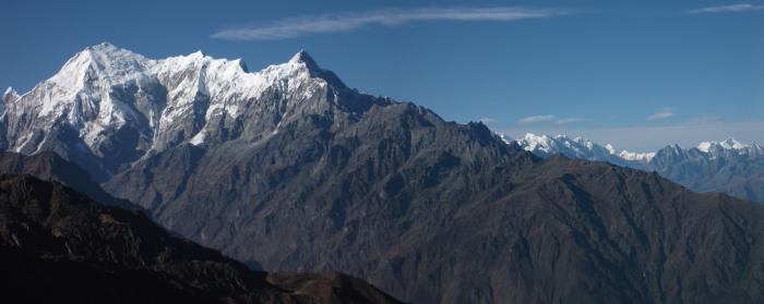
Height of the Himalayas
The Himalayas contain 9 of the 10 highest peaks on our planet, including the highest point in the world - Chomolungma, whose height reaches 8848 m above sea level. Its geographic coordinates are 27°59′17″ north latitude 86°55′31″ east longitude. The average height of the entire mountain system exceeds 6000 meters.
The highest peaks of the Himalayas
Geographic description: 3 main steps
The Himalayas form three main steps: the Sivalik Range, the Lesser Himalayas and the Greater Himalayas, each of which is higher than the previous one.
- Sivalik Range- the southernmost, lowest and most geologically young step. It stretches for about 1700 km from the Indus Valley to the Brahmaputra Valley with a width of 10 to 50 km. The height of the ridge does not exceed 2000 m. Sivalik is located mainly in Nepal, as well as in the Indian states of Uttarakhand and Himachal Pradesh.
- The next step is the Lesser Himalayas, it passes north of the Sivalik ridge, parallel to it. The average height of the ridge is about 2500 m, and in the western part it reaches 4000 m. The Sivalik ridge and the Lesser Himalayas are strongly cut by river valleys, breaking up into separate massifs.
- Greater Himalayas- the northernmost and highest step. The height of individual peaks here exceeds 8000 m, and the height of the passes is more than 4000 m. Glaciers are widely developed. Their total area exceeds 33,000 square kilometers, and the total fresh water reserves in them are about 12,000 cubic kilometers. One of the largest and most famous glaciers - Gangotri, is the source of the Ganges River.
Rivers and lakes of the Himalayas
The three largest rivers of South Asia - the Indus, the Ganges and the Brahmaputra - begin in the Himalayas. The rivers of the western extremity of the Himalayas belong to the Indus basin, and almost all other rivers belong to the Ganges-Brahmaputra basin. The easternmost edge of the mountain system belongs to the Irrawaddy basin.
There are many lakes in the Himalayas. The largest of them are Lake Bangong Tso (700 km²) and Yamjo Yumtso (621 km²). Lake Tilicho is located at an absolute mark of 4919 m, which makes it one of the highest in the world.
Climate
The climate in the Himalayas is quite diverse. Monsoons have a strong influence on the southern slopes. The amount of precipitation here increases in the direction from west to east from less than 1000 mm to more than 4000 mm.

On the border of India and Tibet in Kinnaur Himachal Pradesh (Partha Chowdhury / flickr.com)
The northern slopes, on the other hand, are in the rain shadow. The climate here is dry and cold.
In the highlands there are severe frosts and winds. In winter, temperatures can drop to minus 40 °C or even lower.
The Himalayas have a strong influence on the climate of the entire region. They are a barrier to cold dry winds blowing from the north, which makes the climate of the Indian subcontinent much warmer compared to neighboring regions of Asia located at the same latitudes. In addition, the Himalayas are a barrier to the monsoons blowing from the south and bringing a huge amount of rainfall.
High mountains do not allow these humid air masses to pass further north, which makes the climate of Tibet very dry.
There is an opinion that the Himalayas played a significant role in the formation of the deserts of Central Asia, such as Takla-Makan and Gobi, which is also explained by the rain shadow effect.
Origin and geology
Geologically, the Himalayas are one of the youngest mountain systems in the world; refers to the Alpine folding. It is composed mainly of sedimentary and metamorphic rocks, crumpled into folds and raised to a considerable height.
The Himalayas were formed as a result of the collision of the Indian and Eurasian lithospheric plates, which began approximately 50-55 million years ago. During this collision, the ancient Tethys Ocean closed and an orogenic belt was formed.
Flora and fauna
The flora of the Himalayas is subject to altitudinal zonation. At the foot of the Sivalik Range, the vegetation is represented by swampy forests and thickets, known locally as "terai".

Himalayan Landscape (Jan / flickr.com)
Above, they are replaced by evergreen tropical, deciduous and coniferous forests, and even higher - by alpine meadows.
Deciduous forests begin to prevail at absolute elevations of more than 2000 m, and coniferous forests - above 2600 m.
At an altitude of more than 3500 m, shrub vegetation already predominates.
On the northern slopes, where the climate is much more arid, the vegetation is much poorer. Mountain deserts and steppes are common here. The height of the snow line varies from 4500 (southern slopes) to 6000 m (northern slopes).

Wildlife of the Himalayas (Chris Walker / flickr.com)
The local fauna is quite diverse and, like the vegetation, depends mainly on the height above sea level. The fauna of the tropical forests of the southern slopes is typical for the tropics. Elephants, rhinos, tigers, leopards, and antelopes are still found here in the wild; numerous monkeys.
The Himalayan bears, mountain goats and rams, yaks, etc. are found higher up. In the highlands, there is still such a rare animal as the snow leopard.
The Himalayas are home to many different protected areas. Among them, it is worth noting the Sagarmatha National Park, within which Everest is partially located.
Population
Most of the population of the Himalayas lives in the southern foothills and in the intermountain basins. The largest basins are Kashmir and Kathmandu; these regions are very densely populated, and almost all the land is cultivated.

Bridge over the Ganges (Asis K. Chatterjee / flickr.com)
Like many other mountainous regions, the Himalayas are characterized by great ethnic and linguistic diversity.
This is due to the inaccessibility of these places, due to which the population of almost every valley or basin lived very apart.
Contacts even with neighboring regions were minimal, since in order to reach them, it is necessary to overcome high mountain passes, which in winter are often covered with snow, and they become completely impassable. In this case, some intermountain basin could be completely isolated until next summer.
Almost the entire population of the region speaks either Indo-Aryan languages, which belong to the Indo-European family, or Tibeto-Burman languages, which belong to the Sino-Tibetan family. Most of the population professes Buddhism or Hinduism.
The most famous people of the Himalayas are the Sherpas, who live in the highlands of Eastern Nepal, including in the Everest region. They often work as guides and porters on expeditions to Chomolungma and other peaks.

Annapurna Base Camp, Nepal (Matt Zimmerman / flickr.com)
Sherpas have hereditary high-altitude adaptation, thanks to which, even at very high altitudes, they do not suffer from altitude sickness and do not need additional oxygen.
Most of the population of the Himalayas is employed in agriculture. In the presence of a sufficiently flat surface and water, people cultivate rice, barley, oats, potatoes, peas, etc.
In the foothills and in some intermountain basins, more heat-loving crops are also grown - citrus fruits, apricots, grapes, tea, etc. In the highlands, the breeding of goats, sheep and yaks is common. The latter are used as a beast of burden, as well as for meat, milk and wool.
Sights of the Himalayas
In the Himalayas there are many different attractions. This region has a huge number of Buddhist monasteries and Hindu temples, as well as simply places considered sacred in Buddhism and Hinduism.

Valley of Flowers, Himalayas (Alosh Bennett / flickr.com)
In the foothills of the Himalayas, the Indian city of Rishikesh is located, which is sacred to Hindus, and is also widely known as the yoga capital of the world.
Another sacred Hindu city is Hardwar, located at the point where the Ganges descends from the Himalayas to the plain. From Hindi, its name can be translated as "gateway to God."
Of the natural attractions, it is worth mentioning the Valley of Flowers National Park, located in the Western Himalayas, in the Indian state of Uttarkhand.
The valley fully justifies its name: it is a continuous flower carpet, quite different from ordinary alpine meadows. Together with the Nanda Devi National Park, it is a UNESCO heritage site.
Tourism
Mountaineering and hiking in the mountains are popular in the Himalayas. Of the hiking routes, the most famous track around Annapurna, passing along the slopes of the mountain range of the same name, in the north of the central part of Nepal.

Climber at sunset, Nepal Himalayas (Dmitry Sumin / flickr.com)
The length of the route is 211 km, and its altitude varies from 800 to 5416 m.
Sometimes tourists combine this track with a hike to Lake Tilicho, located at an absolute mark of 4919 m.
Another popular route is the Manaslu trek, which runs around the Mansiri-Himal mountain range and overlaps with the Annapurna route.
How long it will take to complete these routes depends on the physical fitness of the person, the time of year, weather conditions and other factors. In high altitude areas, you should not climb too quickly to avoid symptoms of altitude sickness.
The conquest of the Himalayan peaks is quite difficult and dangerous. It requires good training, equipment and implies the presence of mountaineering experience.
Journey to the Himalayas
The Himalayas attract numerous tourists from Russia and other countries of the world. A trip to the Himalayas can be made at any time of the year, however, it is worth remembering that in winter many passes are covered with snow and some places become extremely inaccessible.
The most favorable time for trekking along the most popular routes is spring and autumn. In summer, the rainy season is here, and in winter it is quite cold and there is a high probability of avalanches.
Himalayas - in the world, the name of which, translated from Sanskrit, literally means "a place where snow lives." Located in South Asia, this mountain range divides the Indo-Gangetic Plain and is home to most of the closest points to the sky on planet Earth, including Mount Everest, the highest peak (the Himalayas are called the "roof of the world" for a reason). It is also known under another name - Chomolungma.
mountain ecology
The Himalayan mountains are characterized by a wide variety of landscape forms. The Himalayas lie on the territory of as many as five states: India, Nepal, Bhutan, China and Pakistan. Three large and powerful rivers originate in the mountains - the Indus, the Ganges and the Brahmaputra. The flora and fauna of the Himalayas is directly dependent on climate, precipitation, mountain heights and soil conditions.

The surroundings of the foot of the mountains are characterized by a tropical climate, while on the peaks there is eternal ice and snow. Annual rainfall increases from west to east. The unique natural heritage and height of the Himalayan mountains are subject to modification due to various climatic processes.

Geological features
Himalayas - mountains consisting mainly of sedimentary and mixed rocks. A distinctive feature of the mountain slopes is their steepness and peaks in the form of a peak or ridge, covered with eternal ice and snow and occupying an area of about 33 thousand km². The Himalayas, whose height in some places reaches almost nine kilometers, are relatively young compared to other, more ancient mountain systems of the Earth.

Like 70 million years ago, the Indian plate is still moving and moving at a distance of up to 67 millimeters per year, and over the next 10 million years it will move 1.5 km in the Asian direction. What also makes the peaks active in terms of geology is that the height of the Himalayan mountains is increasing, gradually rising by about 5 mm per year. Such seemingly insignificant processes over time have a powerful effect on the geological side, in addition, the region is unstable from a seismic point of view, earthquakes sometimes occur.
The river system of the Himalayas
The Himalayas are the third largest ice and snow deposits in the world after Antarctica and the Arctic. There are approximately 15 thousand glaciers in the mountains, which contain about 12 thousand cubic kilometers of fresh water. The highest areas are covered with snow all year round. The Indus, which originates in Tibet, is the largest and full-flowing river, into which many small ones flow. It flows in a southwestern direction through India, Pakistan and flows into the Arabian Sea.

The Himalayas, whose height at the highest point reaches almost 9 kilometers, are characterized by great river diversity. The main water sources of the Ganges-Brahmaputra basin are the Ganges, Brahmaputra and Yamuna rivers. The Brahmaputra joins the Ganges in Bangladesh and together they flow into the Bay of Bengal.

mountain lakes
The highest Himalayan lake, Gurudongmar in Sikkim (India), is located at an altitude of about 5 kilometers. In the vicinity of the Himalayas there are a huge number of picturesque lakes, most of which are located at an altitude of less than 5 kilometers above sea level. Some lakes are considered sacred in India. The Nepalese lake Tilicho in the vicinity of the Annapurna mountain landscapes is one of the highest mountains on the planet.

The great Himalayan mountain ranges contain hundreds of beautiful lakes in India and neighboring Tibet and Nepal. The Himalayan lakes give a special attraction to the magnificent mountain landscapes, many of which are covered with ancient legends and interesting stories.

Climate impact
The Himalayas have a great influence on climate formation. They prevent the flow of cold dry winds in a southerly direction, which allows a warm climate to reign in South Asia. A natural barrier is formed for the monsoons (which cause heavy rainfall) to prevent their northward movement. The mountain range plays its definite role in the formation of the Taklamakan and Gobi deserts.
The main part of the Himalayan mountains falls under the influence of subequatorial factors. In the summer and spring season it is quite hot here: the average air temperature reaches 35 °C. At this time of the year, the monsoons bring with them a large amount of precipitation from the Indian Ocean, which then falls on the southern mountain slopes.

People and culture of the Himalayas
Due to the climatic features of the Himalayas (mountains in Asia) are a fairly sparsely populated region. Most people live in the lowlands. Some of them make a living as guides for tourists and escorts for climbers who come to conquer certain mountain peaks. Mountains have been a natural barrier for many thousands of years. They stopped the assimilation of the interior of Asia with the Indian peoples.
Some tribes are based in the Himalayan mountain range, namely in Northeast India, Sikkim, Nepal, Bhutan, parts of West Bengal and others. More than 80 tribes live in Arunachal Pradesh alone. The Himalayan mountains are one of the largest places in the world with a large number of endangered animal species, as hunting is a very popular activity in the Himalayas. The main religions are Buddhism, Islam and Hinduism. The famous Himalayan myth is the story of Bigfoot, who lives somewhere in the mountains.

Height of the Himalayan mountains
The Himalayas rise almost 9 kilometers above sea level. They stretch for a distance of about 2.4 thousand kilometers from the Indus Valley in the west to the Brahmaputra Valley in the east. Some mountain peaks are considered sacred by the local population and many Hindus and Buddhists make pilgrimages to these places.

On average, the height of the Himalayan mountains in meters, together with glaciers, reaches 3.2 thousand. Mountain climbing, which gained popularity at the end of the 19th century, became the main activity of extreme tourists. In 1953, from New Zealand and Sherpa Tenzing Norgay were the first to conquer Everest (the highest point).

Everest: mountain height (Himalayas)
Everest, also known as Chomolungma, is the highest point on the planet. What is the height of the mountain? The Himalayas, famous for their hard-to-reach peaks, attract thousands of travelers, but their main goal is Chomolungma, 8.848 kilometers high. This place is just a paradise for tourists who cannot imagine their life without risk and extreme sports.
The height of the Himalayan mountains attracts a large number of climbers from all over the globe. As a rule, there are no significant technical difficulties with climbing certain routes, however, Everest is fraught with many other dangerous factors, such as fear of heights, sudden changes in weather conditions, lack of oxygen and very strong gusty winds.

Scientists have precisely established the height of each mountain system on Earth. This was made possible through the use of NASA's satellite surveillance system. By measuring the height of each mountain, they came to the conclusion that 10 of the 14 most on the planet are in the Himalayas. Each of these mountains belongs to a special list of "eight-thousanders". The conquest of all these peaks is considered the peak of the climber's skill.

Natural features of the Himalayas at different levels
The Himalayan swampy jungle, located at the foot of the mountains, is called "terai" and is characterized by a wide variety of vegetation. Here you can find 5-meter thickets of grass, palm trees with coconuts, ferns and bamboo thickets. At an altitude of 400 meters to 1.5 kilometers there is a strip of wet forests. In addition to numerous species of trees, magnolias, citrus fruits and camphor laurel grow here.

At a higher level (up to 2.5 km), the mountainous space was filled with evergreen subtropical and deciduous forests; here you can find mimosa, maple, bird cherry, chestnut, oak, wild cherry, and alpine mosses. Coniferous forests extend up to a height of 4 km. At such a height, there are fewer and fewer trees, they are replaced by field vegetation in the form of grass and shrubs.

Starting from 4.5 km above sea level, the Himalayas are a zone of perpetual glaciers and snow cover. The animal world is also diverse. In different parts of the mountainous surroundings, you can encounter bears, elephants, antelopes, rhinos, monkeys, goats and many other mammals. There are many snakes and reptiles that pose a great danger to people.
The Himalayas are the highest mountain system on Earth. To date, the peak of Chomolungma (Everest) has already been conquered about 1200 times. Including a 60-year-old man and a thirteen-year-old teenager managed to climb to the very peak, and in 1998 the first person with disabilities conquered the peak.
Himalayas - the highest mountain system of the Earth, located between the Tibetan Plateau (in the north) and the Indo-Gangetic Plain (in the south). This majestic mountain system is spread over the territory of India, Nepal, China (Tibet Autonomous Region), Pakistan, Bhutan. The mountain system of the Himalayas at the junction of Central and South Asia is over 2900 km long and about 350 km wide. The average height of the ridges is about 6 km, the maximum height is 8848 m - Mount Chomolungma (Everest). There are 10 eight-thousanders here - peaks with a height of more than 8000 m above sea level.
The Himalayan mountain range, including the Karakoram Mountains (the second highest mountain range located northwest of the western chain of the Himalayas), stretches for more than 2414 km along the northern border of the Hindustan peninsula, separating it from Asia lying to the north. The longest glacier outside the polar regions, Siyachen, is located in Karakorumen, stretching for 76 km.
At Mount Rakaposhi (7788 m) is the steepest slope in the world. This mountain rises 6000 m above the Hunza valley, and the length of the slope is almost 10 km; thus, the total angle of inclination is 31°.
The Karakoram Mountains stretch from the northwest, from northern Pakistan, to the southeast, across Kashmir in northern India. The Himalayas turn to the east, capturing the mountain kingdoms of Nepal, Sikkim and Bhutan, and finally the province of Aru-nachal-Pradesh in the northeastern state of Assam. The northern borders of these countries lie along a mountainous watershed, to the north of which lie the Chinese regions of Tibet and Chinese Turkestan.
To the west of the Karakoram, the mountains split into the Pamir and Hindu Kush, and in the east there is a sharp turn southward to the lower mountains of Northern Burma.
The peoples who inhabit the Himalayas have never been particularly eager to explore the mountains, not dictated by their immediate needs of life; this "high" honor fell mainly to more restless Europeans.
In the 19th century, while the pioneers of mountaineering began to storm the peaks of the European Alps, the Indian government department of land management calculated the location of a peak that seemed to be higher than the rest. Completed in 1856, processing of theodolite surveys of 1849 and 1850 showed that the height of Peak XV on the Tibetan-Nepalese border is 8840 m, and therefore it is the highest peak in the world. It was named after Colonel Sir George Everest, former Surveyor General of India.
After the First World War, the efforts of climbers concentrated mainly on approaches to Everest from the side of the Tibetan slopes, since Nepal was closed to any expeditions.
After the Second World War, Nepal opened its borders to explorers and exploration of the southern slopes began; however, the impregnable peak was conquered only on May 29, 1953 by the New Zealander Edmund Hillary and the Nepalese Sherpa Tenzing Norgay.
Currently, the Himalayas are an area of international mountaineering (mainly in Nepal).
The Himalayas rise above the Indo-Gangetic Plain in 3 steps, forming the Shivalik Mountains (Anti-Himalayas), the Lesser Himalayas (Pir Panjal, Dhaoladhar and others) and separated from them by a chain of longitudinal depressions (Kathmandu Valley, Kashmir Valley and others) Greater Himalayas, which are subdivided to the Assam, Nepal, Kumaon and Punjab Himalayas.
Peaks over 8 km above sea level make up the Great Himalayas, the lowest passes in them are located at altitudes over 4 km. The Greater Himalayas are characterized by alpine-type ridges, huge altitudinal contrasts, powerful glaciation (area over 33 thousand km²). From the east, this ridge is limited by the Brahmaputra valley, and from the west by the Indus (these powerful rivers cover the entire mountain system from three sides). The extreme closing northwestern peak of the Himalayas is Nanga Parbat (8126 m), the eastern one is Namcha Barwa (7782 m).
The peaks of the Lesser Himalayas on average reach 2.4 km, and only in the western part - 4 km above sea level.
The lowest ridge, Shivalik, stretches along the entire mountain system from the Brahmaputra to the Indus, nowhere exceeding 2 km.
The main rivers of South Asia - the Indus, the Ganges, the Brahmaputra - originate in the Himalayas.
Highest peaks[edit | edit source]
The Himalayas are home to 10 of the 14 eight-thousanders in the world.
The highest peak of the Earth is located on the border of Nepal and China (Tibet Autonomous Region). In Nepalese, she is called the King of Heaven - Sagarmatha, and in Tibetan - the Divine Mother of the Earth (Chomolungma). The name Everest was given to the mountain during the first measurement of its height in the middle of the 19th century in honor of George Everest (eng. George Everest, 1790-1866), the chief surveyor of the topographic service of British India. The top of the mountain is located at an altitude of 8848 m above sea level.
The highest mountains in the world separate Hindustan from Asia.
Most travelers to reach the Himalayas fly to India or Pakistan and then travel north by train, highway and finally on foot. The way from the north, from Tibet, is more difficult.
The Himalayas, home to 96 of the world's 109 peaks over 7,300 meters, are undeniably the greatest mountain range on Earth. And although the South American Andes form a longer (about 7500 km) mountain range, they are not so high. But facts and figures are one thing, and the awe-inspiring view of the Himalayas is quite another.
Although the highest mountain on our planet is better known throughout the world under the English name Everest, its Nepalese name - Chomolungma - "Mother Goddess of Snows" - creates an image that can be applied to all the Himalayas.
The highest ascent is on the southern slope of Annapurna I (8091m) and the longest ascent is on the Rupal-facing slope of Nangaparbat Mountain in Karakoram at an elevation of 4482m.
Of the highest peaks of the ridge, K2 in Karakoram (8661 m) and Kangchenjunga (8586 m) should be named.
The globe, in Asia, in China, Pakistan, India, Bhutan and Nepal. They stretch in an arc about 2500 km long and 200-350 km wide. The area is about 650 thousand km 2. Height up to 8848 m (Mount Chomolungma - the highest peak in the world). 10 peaks exceed 8000 m, more than 100 - 7000 m.
In the north they are limited by the tectonic valleys of the upper reaches of the Indus and Brahmaputra rivers (Matsang, Tsangpo), in the west - by the Hinduraj ridge, in the east - by the Dihang gorge of the Brahmaputra river, in the south - by the Indo-Gangetic plain. The Himalayas are an important orographic, climatic and biotic barrier between the deserts of Central Asia and the landscapes of the monsoon tropics of South Asia.
Relief. The Himalayas are characterized by a clear strike of orographic elements from the northwest to the southeast. They include several parallel mountain ranges, rising from south to north with three giant steps, dissected by river gorges into separate massifs and blocks. The first step (above the Indo-Gangetic plain) is formed by the Sivalik ridge (Anti-Himalayas), height up to 3647 m (Mount Chaur). It reaches its greatest width (up to 120 km) in the western and central parts, to the east of 88° east longitude it narrows to 5-10 km. It is strongly dissected by deeply incised river valleys. The second stage - the Small (Low) Himalayas - is separated from Sivalik by a tectonic fault, along which there is a number of intermountain basins (duns), occupied in the past by lakes. It consists of a system of massifs and ridges. The ridges are strongly dissected, the southern slopes are steep, the northern ones are more gentle. In the west rises the Pir-Panjal range (up to 6632 m), in the central part - the Dhaoladhar (up to 5067 m) and Mahabharat (up to 2891 m) ranges with sharp ridges and deep valleys. By a chain of intermountain depressions and ancient glacial basins (Kashmir, Kathmandu, etc.), the Small Himalayas are separated from the highest level - the Great (High) Himalayas with the highest massifs and peaks covered with glaciers. This part of the Himalayas forms a powerful alpine ridge 50-90 km wide, with passes lying above 4500 m. The northern slopes have soft outlines, the southern slopes are steep, dissected by deep gorges. Glacial landforms are typical (kars, troughs, exaration forms, terminal moraines). The Great Himalayas begin in the northwest of the Nanga Parbat massif, where they are widest (over 300 km). High uplands (over 5000 m) and the Zaskar mountain range (up to 7756 m) are also located here. To the east of the Teesta river valley, the Greater Himalayas decline significantly. This part is characterized by deeply incised river valleys, relatively poorly dissected massifs with domed peaks. In the Himalayas, the intensity of erosion processes is high, landslides and mudflows are frequent, and avalanches occur in the middle and high mountains. From west to east, the Himalayas are usually divided into Punjab (from the gorge of the Indus River in the northwest to the valley of the Sutlej River), Kumaon (between the valleys of the Sutlej and Kali rivers), Nepal (in Nepal), Sikkim (within the Indian state of Sikkim) and Assamese (west of Bhutan).

Sivalik Ridge.
Geological structure and minerals. In tectonic terms, the Himalayas are a fold-cover mountain system of the same name, which is a link in the Cenozoic Alpine-Himalayan mobile belt. In their structure, three zones are distinguished, corresponding to the steps of the relief; in addition, the High Himalayas divide into two zones. The northern zone of the High Himalayas, called the Tethyan Himalayas, or Tethys-Himalayas, is composed of a sequence of marine sediments of the Middle Proterozoic - Eocene of great thickness (up to 17 km), accumulated on the gently sloping continental shelf of the Indian subcontinent (on the southern margin of the Tethys paleoocean). In the north, the Tethyan Himalayas are bounded by the Indus-Tsangpo tectonic basin, which marks the tectonic suture of the same name (suture), which is considered as a relic of the surface of the subduction zone, along which the Tethys crust sank northward under the southern margin of Eurasia with the formation of the Trans-Himalayan volcanic-plutonic belt (see the article Gandishishan ). In the suture zone, ophiolites come to the surface (their covers are established in the Tethyan Himalayas), metamorphic formations, sedimentary and igneous complexes. In the south, the Tethyan Himalayas are separated by a fault gently inclined to the north from the Central Crystalline Zone of the High Himalayas. This zone is composed of repeatedly metamorphosed, mainly Precambrian complexes - micaceous schists, quartzites, gneisses, migmatites, which are intruded by Miocene leucogranites. The last metamorphic event in the zone corresponds to conditions of very high temperatures and relatively low pressures. The metamorphic formations of the Central Crystalline Zone are thrust (along the Main Central Thrust) and partially overlie the Low Himalaya complexes, forming many isolated tectonic remnants. The zone of the Low Himalayas is formed by sedimentary strata of the Upper Proterozoic - Lower Eocene (sandstones, clays, limestones, tillites), similar to the cover of the Hindustan platform. The deposits have undergone greenschist metamorphism and have a cover-thrust structure. In the south, the zone of the Low Himalayas thrusts (along the Main Frontier Thrust) on the zone of the Cis-Himalayas (or the Outer Himalayas), which in tectonic terms is a foredeep that has arisen in recent times in front of the front of the growing Himalayan orogen and is filled with Miocene sandy-argillaceous and Pliocene coarse clastic molasses of common up to 7 km. The folded molasse complexes of the Cis-Himalayas are separated by a system of gentle faults of the Frontal Himalayan thrust from the undeformed and not involved in the uplift molasses of the Indo-Gangetic depression.
The formation of the Himalayas as a cover-folded mountain structure is associated with a collision (collision) of the Hindustan block with Eurasia, which began about 55 million years ago (at the end of the Paleocene). The maximum deformations occurred: at the beginning of the Miocene (20-25 million years ago), when the Main Central thrust was formed; in the late Miocene (15-10 million years ago) - the Main Frontier Thrust; at the end of the Pliocene - the Main Frontal Thrust. The recent uplift of the Himalayas is accompanied by intense seismicity concentrated mainly along thrust zones.
A few deposits of ores of copper and gold are known; chromites, precious stones (sapphire, etc.) associated with metamorphic and igneous rocks of the Low and High Himalayas. Deposits of oil and natural combustible gas have been discovered in the Cis-Himalayas.

Climate. The southern slopes of the Himalayas are heavily influenced by the Indian summer monsoon. The amount of precipitation decreases from the east (4000-5500 mm per year) to the west (1000-2000 mm). The hinterland receives about 400-750 mm of precipitation per year. Everywhere on the southern slope up to a height of 3000 m, the average annual temperatures are positive, above 4500 m - the area of negative summer temperatures. The climate of the western part of the Himalayas is characterized by sharp fluctuations in temperature, strong winds. Average temperatures in July are about 18 °С, in January from -10 to -18 °С. The influence of the monsoon manifests itself in July - August south of the Pir-Panjal ridge. Winter precipitation is associated with cyclones bringing rain and snow. The main passes are cleared of snow at the end of May. The climate of the eastern part is hotter, with a pronounced monsoonal humidification regime. Summer temperatures at an altitude of 1500 m reach 35 °C, in the valleys they rise to 45 °C. In winter, at an altitude of 1800 m, the average January temperature is 4 °C. Snowfalls annually occur above 2200-2500 m, in the valleys there are thick fogs. Above 5000 m precipitation falls in the form of snow all year round. The climate of the northern slopes of the Himalayas is cold alpine desert. Daily temperature amplitudes reach 45 °C, precipitation is about 100 mm per year. In summer, at an altitude of 5000-6000 m, there are positive temperatures only during the day. In winter, snow often evaporates without melting.
Glaciation. On the southern slopes of the Punjab Himalayas, the snow line passes at an altitude of 4400-4600 m, in the Nepal Himalayas (on the slopes of Chomolungma) - 4700-4800 m, in the Assam Himalayas - 4600 m. On the northern, drier, slopes of the Himalayas, it rises to 5800-6100 m. The high position of the snow line and the significant steepness of the slopes do not contribute to the formation of large glaciers. The area of modern glaciation of the Himalayas is small - about 33 thousand km 2. Most glaciers are grouped around the highest massifs. The largest glaciers in the Punjab Himalayas are Gangri (length 21 km), Shaffat (16 km), Milang (16 km), in the Kumaon Himalayas - Milam (20 km) and Gangotri (32 km, the largest in the Himalayas). In the Nepalese Himalayas, in the Chomolungma region, there are about 600 glaciers, including the Western Rongbuk and Khumbu 22 km long, in the Sikkim Himalayas, in the area of the Kanchenjunga massif, there are Zemu glaciers (31 km) and Kanchenjunga (24 km). Most of the glaciers are retreating at an average rate of 10-15 m per year. The glaciers of the valleys are predominantly dendritic, of the Himalayan type, descending 1300-1600 m below the snow line. In the western part of the Himalayas, valley glaciers of the Turkestan type predominate, fed mainly by avalanches and avalanches of hanging glaciers. On the steep slopes - hanging and cirque glaciers. The northern slopes are characterized by gigantic curtains of corrugated ice that cover many of the peaks to their summits. Tongues of some glaciers are covered with a moraine cover for a considerable extent.
Rivers and lakes. Despite the high altitude, the Himalayas are not a watershed of the rivers of the Indian Ocean basins and the endorheic region of Central Asia. Due to the presence of through antecedent gorges, the sources of the Indus, Sutlej, Karnali, Arun rivers are located in the Karakoram and on the Tibetan Plateau. The largest rivers of South Asia, the Ganges and the Brahmaputra, originate on the slopes of the Himalayas. The river network is more developed on the southern slope. In the upper reaches of the river, they are fed by snow and glaciers; in the middle and lower - rain, with a maximum flow of water in summer. The valleys are narrow and deep. The rivers have huge hydropower resources, which are practically not used. Large hydroelectric power stations and reservoirs have been created on the Sutlej and Beas rivers. Lakes (tectonic and glacial) are located mainly in the western part of the Himalayas below 5000 m (Vular, Tso-Morari, etc.); large alpine lakes - Bangong, Mapam Yumtso. When glacial lakes break through, glacial mudflows can occur.

Soils, flora and fauna. The landscapes of the Himalayas are very diverse, especially on the southern slopes. The maximum number of altitudinal belts is characteristic of the most humid slopes of the eastern part of the Himalayas. The foothills of the mountains are bordered by a strip of terai - swampy tree-shrub thickets (jungle) on meadow-marsh tropical soils. Above the slope, moist evergreen tropical forests grow on mountain red soils. Dipterocarp, palm, pandanus, tree ferns intertwined with vines (up to 400 species) predominate. At an altitude of 1200-1500 m, mountain evergreen subtropical forests of oaks, laurels, magnolias, tea trees (castanopsis, phebe) dominate. Above 2000-2200 m, they are replaced by mixed deciduous forests on brown forest soils, in the forest stand of which species of temperate latitudes appear - maples, alder, hazel, birch and conifers (Himalayan pine, Himalayan spruce, dense fir). From a height of 3000 m begins a belt of mountain coniferous forests of pine, fir, hemlock, yew, juniper. At an altitude of 3700-3900 m, it is replaced by a subalpine belt - a crooked forest of huge rhododendrons and junipers with the participation of ferns, above 4000 m - a belt of alpine meadows, the upper limit of which runs at an altitude of about 5000 m, individual plants (Arenaria, edelweiss) rise to a height of 6100 m. In the central part of the Himalayas, in the spectrum of altitudinal zones, there is no belt of humid evergreen tropical forests, and up to a height of 600-1000 m, deciduous forests from lard with the participation of terminalia, albition, etc. dominate.
In the more arid western part of the Himalayas, the lower parts of the slopes (up to 600 m) are occupied by sparse xerophytic forests and shrubs with wild olive, an admixture of acacia, pomegranate, and oleander on mountain brown soils. Above (up to 1200-1500 m), monsoon deciduous forests grow with dominance of fat on mountain red soils, which are replaced by mountain subtropical mixed forests of holm oak and mountain pines with evergreen undergrowth. From a height of 2000-2500 m, mountain mixed subboreal forests of long-coniferous pine (chir), fir, Himalayan cedar (deodar) with the participation of oaks and maples dominate on low-humus brown forest soils. In the belt of 3000-3500 m, mountain coniferous forests of fir with an admixture of birch dominate on podzolized brown soils. Above 3500 m - subalpine birch crooked forest, thickets of juniper and rhododendrons, giving way to a belt of alpine meadows and shrubs on mountain meadow soils. The upper boundary of the distribution of vascular plants is 6300 m. The northern slope is characterized by desert-steppe landscapes with polster and xerophytic grasses on thin, stony mountain-desert soils. Woody vegetation (willows, poplars) is found in river valleys.
About 300 species of mammals live in the Himalayas, more than 10 of them are endemic (golden langur, Himalayan tahr, pygmy pig, etc.), 175 species of reptiles (about 50 species are endemic), 105 species of amphibians. The avifauna includes about 1000 species (15 species are endemic). The fauna of the Terai and low mountains of the Himalayas belongs to the Indo-Malay faunistic region. Large mammals live here - elephants, rhinos, gaurs, wild boars, several species of deer (muntzhak, sambar), predators - tigers and leopards, red wolf; birds - peacocks, pheasants, parrots. In the eastern part of the Himalayas, there is a binturong (viverrid family). The fauna of the middle and high mountains belongs to the Chinese-Himalayan subregion of the Holarctic region. Wild yak, musk deer, red deer (hangul), mountain sheep (argali, blue sheep), markhor goat, goral, takin, black Himalayan bear live in the forest and alpine belts. Clouded leopard and snow leopard (irbis) are endangered. Of the birds, the Himalayan snowcock, the Himalayan crested pheasant, and tragopans are common.
The most famous protected areas of the Himalayas are the national parks Corbett, the Greater Himalayas, Namdapha, Kanchenjunga (India); The World Heritage List includes the Manas Reserve, the Nandadevi National Parks and the Valley of Flowers (India), the Kathmandu Valley, the Chitwan and Sagarmatha National Parks (Nepal). In the Himalayas, mainly in Nepal, mountaineering is widely developed. Climatic resorts - Shimla, Macypi, Darjeeling and others (India).
The main occupation of the population is agriculture. On the northern slope of the Greater Himalayas (near Lake Tangra-Yumtso) are the upper boundaries of agriculture in the world. Excessive grazing of livestock in alpine meadows and forests has led to increased erosion and mudflow processes.
Lit .: Singh G. Geography of India. M., 1980; Senkovskaya N. F. Land resources of the Himalayas and problems of their use // Bulletin of Moscow State University. Ser. 5. Geography. 1982. No. 6; she is. Features of the distribution of mudflow phenomena in the Himalayas // Ibid. 1984. No. 6; Kononov Yu. V. The country of subtropics and snow-capped mountains. M., 1985; Bedi R. Animal world of India. M., 1987; Dolgushin L. D., Osinova G. B. Glaciers. M., 1989; Golubchikov Yu. N. Geography of mountainous and polar countries. M., 1996; State of Nepal's environment. Kathmandu, 2000; Khain V. E. Tectonics of continents and oceans (year 2000). M., 2001; Inventory of glaciers, glacial lakes and glacial lake outburst floods monitoring and early warning systems in Hindu Kush - Himalayan region. Kathmandu, 2002.
N. N. Alekseeva; Ark. V. Tevelev (geological structure and minerals).
The name Himalaya is derived from the spirit of the Sanskrit words: hima and alaja, which means "abode of snows." The highest mountains on earth occupy 80% of the area of Nepal. The average height of the Himalayas is 6,000 meters above sea level. The length of these high mountains is 2,500 km. But it is on the territory of Nepal that there are eight eight-thousanders - the highest mountain, whose height is more than 8,000 meters. Therefore, all climbers in the world dream of climbing the Himalayas at least once in their lives. Neither danger to life, nor cold, nor financial costs stop them. At the same time, the financial costs are quite significant. After all, if you want to conquer the peak, then in Nepal, just for the right to climb, you will have to pay a fairly serious amount, which is more than one thousand dollars. Here, this fee is called royalty. If you want to conquer Everest, then you will also have to stand in line, maybe even two years. With such a large number of people who want to conquer the Himalayas, there are peaks that are not popular.

For tourists eager to challenge the mountains, special routes have been laid at an altitude of 5.5 thousand meters. Those who manage to make the ascent will receive a well-deserved reward - landscapes of dangerous and deep gorges with lush vegetation and lush greenery of unforgettable beauty, or snow-capped rocky peaks. The most popular among ordinary tourists without special training is the route around Annapurna. During the days of the journey, those who decide to undertake such a journey, in addition to the excellent landscapes of mountainous Nepal, can also observe the life of local residents.

The highest mountain in the Himalayas is Mount Everest (8848 meters). Every student knows about this. In Tibet, she is called Chomolungma, which means "Mother of the Gods", and in Nepal - Sagarmakhta. All climbers dream of conquering Everest, but only climbers of the highest class can conquer it.

The Himalayas arose during the period of orogeny - the Alpine tectonic cycle and, by the standards of geology, very young mountains. The Himalayas arose in the place where the Eurasian and Indian subcontinental plates collided. Mountain building continues here today. The average height of the mountains increases annually by an average of 7 mm. That is why earthquakes are so frequent here.

In the Himalayan mountains directed to the sky, it is quite common to find fossilized marine organisms. They are called saligrams. According to scientists, their age is about 130 million years. Saligrams are like messages from the Ice Age. They are the best proof that the Himalayas "grew" out of the water. The Nepalese consider them the earthly incarnation of their god Vishnu. For the Nepalese, saligrams are sacred. Their export from the territory of Nepal is prohibited.

Video: "Climbing the top of Tulagi in Nepal (7059 m.) in 2010."
Film: Road to the Himalayas
Also, you can watch the 1999 Nepalese film The Himalayas (dir. Eric Valli) and the 2010 film NANGA PARBAT.
In conclusion, a few more photos of the Himalayas:


