ancient travelers. Famous travelers of ancient times When they traveled
An outstanding traveler of antiquity was a Greek historian and geographer Herodotus from the port city of Halicarnassus on the western coast of Asia Minor. He lived in an era when ancient Greece was waging a hard struggle with the mighty Persian power. Herodotus decided to write the history of the Greco-Persian wars and tell in detail about the nature and life of the population of the countries that were at that time under the rule of Persia.
Travels of Herodotus refer to 460-450 years. BC e. He visited the Greek cities on the coast of Asia Minor and the countries of the Balkan Peninsula. Herodotus made a long journey to Scythia - the southern regions of the Russian Plain.
Before Herodotus, Scythia was little known to the Greeks, although they traded with it. The information of Herodotus is of great importance for historians. Herodotus, who was born and raised in a mountainous and wooded area, was struck by Scythia with huge treeless plains and rich pastures. The Scythian winter, lasting several months, seemed harsh to Herodotus. He wrote that in Scythia, spilled water “does not make mud” (that is, it freezes) in winter. Summer seemed cold and rainy too. Herodotus was also struck by the huge rivers of Scythia - Gipanis (Southern Bug), Borisfen (Dnepr), Tanais (Don), etc. He knew from childhood that in Greece the rivers originate in the mountains, but in Scythia the mountains. No. In his opinion, these rivers should have started in some large lakes. Despite this erroneous view, Herodotus generally correctly characterized the Scythian plain. Herodotus was especially interested in the tribes that inhabited Scythia and neighboring areas. The Scythians, who lived in the steppe and partly forest-steppe zone, were divided into farmers and pastoralists. The nomadic way of life of the Scythian herders seemed unusual to the Greeks.
Herodotus collected interesting, sometimes semi-fantastic information about the peoples who lived to the north and northeast of the Scythians. He learned about the hunters - Tissagets and Irks, who inhabited the "stony and uneven land" (probably the Urals and Kama region), and about the dense forests growing there, where beavers, otters and other fur-bearing animals live. Further, at the foot of high and inaccessible mountains (this is probably the Ural Range), the territory was occupied by the Argipean tribes, who had shaved heads and flat faces with large chins.
Herodotus was informed that even farther lie the habitats of one-eyed people - the Arimaspians. There's a lot of gold there. But it is guarded by vultures - terrible monsters, similar to lions, with eagle beaks and wings. In the Far North, beyond Scythia, there are uninhabited lands where it is very cold, it snows all the time and it is night for half a year.
From Scythia Herodotus went to the Black Sea coast of the Caucasus. From the inhabitants of Colchis, he learned that a huge sea (Caspian) stretches beyond the mountains, and behind it - a vast plain. Warlike tribes live there - Massagets. Before Herodotus, the Greeks imagined the Caspian as a bay of the ocean and did not know what lay to the east of it.
Returning to his homeland, after some time Herodotus set off on a new journey - to the interior of the peninsula of Asia Minor and the Mesopotamian lowland. He described Babylon in detail, with its high stone walls, huge library, and sumptuous terraced gardens. In Mesopotamia, he was especially interested in date palms, from the fruits of which the population prepared bread, wine and honey. Herodotus liked the ships sailing along the Tigris and Euphrates. Their round body was made of wicker and covered with a leather case.
In Babylon, Herodotus learned a lot about "the most distant of the countries of the East." Such was India for the Greeks. He was told that gold is mined in large quantities in India, that there are many outlandish plants there: reed, bamboo, from one knee of which it is possible to make a boat; cereal, the grain of which is “boiled and eaten with the husk” (rice); trees with fruits in the form of a ball of wool - from it the inhabitants of India make their own clothes (cotton).
Herodotus spent a lot of time in Egypt. He visited the cities there, at the famous pyramids and the Sphinx, climbed up the Nile to Siena (modern Aswan). Herodotus noted the peculiarities of the nature of Egypt: the absence of clouds and rain, the rise and flood of water in the Nile in the hottest time of the year, animals unknown in Greece and Asia Minor (crocodiles, hippos, fish and birds).
After Egypt, Herodotus visited the cities of Northern Libya (Africa), where he collected interesting information about the inhabitants of the northern part of the African continent and oases in the desert sandy zone. Herodotus' information about the ancient population of the Sahara is confirmed by the latest archaeological data (drawings on the rocks in Tibesti, Fezzan and Oran).
The great traveler of ancient Greece was also an astronomer Pytheos from Massilia (Marseille). The expedition of Pytheas was organized by the merchants of Massilia to find ways to the distant northern countries, where there is tin and amber. Pytheas not only fulfilled the order of the merchants, but also made several geographical discoveries that glorified his name.
On such ships, the Greeks went out into the Atlantic Ocean.
Pytheas' journey began in March 325 BC. e. Two fifty-oared ships left the harbor of Massilia. Their path lay to the Strait of Gibraltar, which was in the hands of the Carthaginians and was closed to the passage of foreign ships. During a thunderstorm, under the cover of a dark night, Pytheas managed to bypass the guard and go out into the Atlantic Ocean. Day and night ships sailed west, then north, trying to get as far away from dangerous places as possible.
During an overnight stay at the mouth of one of the Pytheas, observing the ebb and flow, the first one expressed the correct idea that this phenomenon is associated with the attraction of the Earth's water shell by the Moon.
Sailing north, Pytheas reached the large Celtic city of Carbilon at the mouth of the Loire. From local residents, he learned that tin comes to them from more northern countries. On the coast of the Brittany peninsula and on the island of Uxisama (modern Ouessant in Western France), Pytheas met with the Veneti and Osismi tribes, who told him that tin was brought from the islands lying to the north. One of the islands is called Albion or Britannia. Next to it lie the small islands of the Cassiterids ("Tin"). Taking an interpreter, Pytheas sailed on and, reaching a narrow strait (Pas de Calais), crossed to the island of Britannia.
On the southwestern tip of the island, he got acquainted with the mining and smelting of tin. Having bought tin, Pytheas sent one ship to Carbylon, and on the other he continued sailing north along the western coast of Britain.
Pytheas was the first to observe and establish the relationship between geographic latitude and the length of day and night. The further he moved north (and at this time it was summer in the Northern Hemisphere), the day became longer and longer. Off the northern coast of Britain, he noted the duration of the day 18 hours, and the night - 6 hours.
From the coast of Northern Scotland, Pytheas headed for the Orkney and Shetland Islands. From here he made the famous voyage to the distant country of Thule, with which the inhabitants of Britain traded. Where could this legendary country of Thule be located? Most modern scientists believe that Thule is the region of Trondheimsfjord on the western coast of Norway at 64 ° N. sh.
In ancient times, no traveler before Pytheas rose to such high latitudes. Sailing along the southern shores of the North Sea, Pytheas reached the area where the Germanic tribes lived, mining amber. They collected pieces of amber left by the sea on the shore at low tide. They exchanged this amber with the Celts for iron products. From the Celts, amber came to Massilia and other Mediterranean cities.
Pytheas failed to penetrate further to the east. Off the western coast of the Jutland peninsula, he fell into thick fog. Pytheas concluded that the human habitat ends here. Having exchanged iron products for amber, Pytheas set off on his return journey. He left descriptions of his travels, but they have not completely reached us. We know about them from the passages that have been preserved by other ancient authors.
Hannon (505). - Herodotus (484). - Pytheas (340). - Eudoxus (146). – Stra bon (63). Hanno of Carthage. - Happy Islands (Canaries), Evening Horn, South Horn, Rio de Oro Bay. – Herodotus visits Egypt, Libya, Efi opium, Phoenicia, Arabia, Babylonia, Persia, Media, Colchis, Caspian the sea, Scythia and Thrace. - Pytheas explores the shores of Iberia and Celtica, the English Channel, acute Albion, Orcadian (Orkney) Islands, the land of Thule. - Nearchus circles the Asian coast from the Indus to the Persian Gulf. - Eudoxus meets the western coast of Africa. - Strabo pute marches through inner Asia, Egypt, Greece and Italy.
The first traveler, who was mentioned in historical sources, was Hanno, sent by the Carthaginian Carthage was founded by the Phoenicians around 850 BC on the northern coast of Africa, in the Gulf of Tunis. Senate to colonize new territories on the west coast of Africa. The message about this expedition was written in Punic The Romans called the Carthaginians Punas; hence the name of the language - Punic language and translated into Greek; it is known as Hanno's circumnavigation of the world by sea. What era did this explorer live in? Historians have different opinions. But the version according to which his visit to African shores dates back to 505 BC is considered the most reliable. The exact date of Hanno's expedition cannot be established. Modern scholars attribute it to the 5th or 6th century BC. The description of this voyage has come down to us in the form of an "adventure novel", in which reliable facts are intertwined with fictional ones. However, the geographical description of the western coast of Africa, the story of the steppe fires inside the country leave no doubt about the authenticity of the journey, which later became overgrown with various fables. Gannon was the first navigator to visit the west coast of Africa. He sailed along this coast from the Strait of Gibraltar to the south for about 4,500 kilometers. Nineteen centuries later, it took Portuguese navigators fifty years to explore the coast that Hanno bypassed.
Hanno left Carthage at the head of a fleet of sixty galleys with fifty oarsmen each; the ships carried thirty thousand men and supplies for the long voyage. Settlers - it is quite possible to call them that - had to settle in new cities. Carthaginians
were going to establish new settlements on the western coast of Libya, in other words, Africa.
The fleet safely passed the Pillars of Hercules The Pillars of Hercules are two mountains on the European and African shores of the Strait of Gibraltar, allegedly erected by the mythical hero Hercules. According to the ancient Greeks, the Pillars of Hercules were the western edge of the known world.- the rocks of Gibraltar and Ceuta, towering above the strait, and ventured south into the Atlantic Ocean. Two days later, Hanno made a stop and founded the city of Phimiaterium in this place. Continuing the voyage, he then rounded Cape Solosit, entered into trade relations with the locals and headed further, to the mouth of a large African river, on the banks of which a tribe of nomadic shepherds lived. Having entered into a friendly alliance with them, the Carthaginian navigator continued to move south, along the desert coast of the Sahara; then he reached the island of Kerna, which, judging by the description, is at the same distance from the Pillars of Hercules as the Pillars of Hercules are from Carthage. What island was it? Without a doubt, one of the islands belonging to the Happy (now Canary) group.
The journey continued, and soon Hanno arrived at the mouth of the Hreta River, Probably the Senegal River forming a wide bay. When the Carthaginians sailed up the river, the local inhabitants - the Negroes - met them with a hail of stones.
Having completed their reconnaissance, the fleet returned to the mouth of the river and, after a twelve-day voyage southward, reached a mountainous area abounding with fragrant trees and balsam plants. Then the fleet stopped in a vast bay with flat, low-lying shores. This land, so calm during the day, was lit up at night with pillars of flame, either from the fires kindled by the natives or from the spontaneous combustion of dried grass.
Five days later, Hanno and his companions rounded the cape and
entered the bay, which they called "Evening Horn". There, says the traveler, he heard the sounds of flutes, the rumble of cymbals, tambourines Cymbals are an ancient musical instrument in the form of copper cymbals. The tambourine is a percussion instrument that resembles a tambourine. and the roar of countless voices. "The oracles who accompanied the Carthaginian expedition advised them to flee from this terrible land." They obeyed, and the fleet continued sailing to lower latitudes.
Then Gannon reached the bay, which was called the "South Horn". Geographers believe that this bay, apparently, was the mouth of the Rio de Oro, which flows into the Atlantic Ocean near the Tropic of Cancer. The "South Horn" is now Sherborough Bay in the British colony of Sierra Leone, located on the coast of the Gulf of Guinea
In the depths of this bay, an island abounded with gorillas, which the Carthaginians mistook for hairy savages. They managed to capture three "women", but soon they were forced to kill them, since the fury of these monkeys was indomitable. It must be assumed that these were not gorillas, but chimpanzees

The South Horn was without a doubt the end point reached by the Punic expedition. Some historians claim that the Carthaginian fleet did not go further than Cape Bojador, located two degrees north of the tropic, but the first point of view seems to us more likely.
Upon reaching the South Horn, Gannon began to run short of provisions. Then he turned north and returned to Carthage, where, by his order, a marble slab was placed in the temple of Baal Moloch with a description of the journey “around the world” carved on it.

After the Carthaginian navigator, the most famous of the ancient travelers in historical times was the Greek scientist Herodotus, nicknamed the "father of history." For our purpose, we will separate the traveler from the historian and follow him to the countries he has visited.
Herodotus was born around 484 BC Biographical information about Herodotus is extremely scarce. The exact years of his life are unknown; it is believed that he was born about 484 BC and died in 424 or 426 BC. Herodotus is the author of the first large historical work that has come down to us, the famous "History", in which he included rich geographical material collected by him during his long travels. It is impossible to say exactly which countries Herodotus visited during his travels. There is no doubt that he visited Egypt and the northern coast of the Black Sea. In the east, it probably reached Babylon. Herodotus also speaks of a journey to India, but this description has no historical basis. in the Asia Minor city of Halicarnassus. He came from a wealthy and distinguished family with extensive trade connections, which may have contributed to the development of the instincts of the traveler-explorer, awakened in the boy.
In that era, there was no consensus on the shape of the earth. The school of Pythagoras has already begun to spread the doctrine that the earth is spherical. But Herodotus did not take any part in these disputes, which worried the scientists of his time. In his early youth, he left his homeland with the intention of carefully studying distant countries, about which very scarce and contradictory information reached.
In 464, at the age of twenty, he left Halicarnassus. Apparently, Herodotus first went to Egypt, where he visited the cities of Memphis, Heliopolis and Thebes. During the trip, he managed to get a lot of valuable information about the floods of the Nile. In his notes, he gives various opinions regarding the origins of this great river, which the Egyptians revered as a deity.
“When the Nile floods,” says Herodotus, “nothing is visible but cities; they seem to be built on top of the water and resemble the islands of the Aegean."
Herodotus tells about the religious rites of the Egyptians, about how they make sacrifices to their gods and how they solemnly celebrate holidays in honor of the goddess Isis in the city of Buziris, the ruins of which are still visible today. Herodotus also tells how the Egyptians revere wild and domestic animals, considering them sacred, and give them funeral honors. With the precision of a real naturalist, he describes the Nile crocodile and its habits; describes the methods by which crocodiles are caught. We will find out what other animals are found there and what the Egyptian hippopotamus, the ibis bird, and various snakes represent. Herodotus draws the domestic life of the Egyptians, their customs, games, talks about the art of embalming the dead, which the Egyptians mastered to perfection. Further, he reports what structures were erected under Pharaoh Cheops: a labyrinth built near Lake Merisa, the remains of which were discovered in 1799; lake Meris, created by human hands, and two pyramids rising above the surface of its waters; Herodotus tells with surprise about the temples erected in Memphis, about the famous colossus of whole stone, over the transportation of which from Elephantine Elephantine Island (Ivory) is located on the Nile River, at the first rapids, on the border of Egypt and Sudan two thousand people worked in Sais for three years.
Having carefully studied Egypt, Herodotus went to other countries of Libya, that is, Africa, but at the same time the young traveler did not even imagine that Africa extended far south beyond the Tropic of Cancer; he believed that the Phoenicians could go around this mainland and return to Egypt through the Strait of Gibraltar. Here the author has in mind the story of Herodotus, heard by him in Egypt, about the journey of the Phoenician navigators around Africa, undertaken on the orders of the Egyptian pharaoh Necho around 600 BC. This enterprise is unparalleled in the history of geographical discoveries, so we will give the full brief story of Herodotus: “Libya, it turns out, is surrounded by water, with the exception of the part where it borders on Asia; the first to prove this, as far as we know, was the Egyptian pharaoh Necho. Having suspended the digging of a canal from the Nile to the Arabian Gulf [Red Sea], he sent the Phoenicians in ships out to sea with orders to sail back through the Pillars of Hercules [Strait of Gibraltar] until they entered the North [Mediterranean] Sea and arrived in Egypt. The Phoenicians set sail from the Erythrean [Red] Sea and entered the South Sea [Indian Ocean]. At the onset of autumn, they landed on the shore and, wherever they landed in Libya, they sowed the land and waited for the harvest; after harvesting the bread, they sailed on. So two years passed in the voyage, and only in the third year they rounded the Pillars of Hercules and returned to Egypt. They also told me, which I do not believe, and someone else, perhaps, will believe that during the voyage around Libya, the Phoenicians had the sun on their right side. So Libya became known for the first time "
Listing the peoples living in Libya, Herodotus mentions the shepherd tribes wandering along the coast of Africa, and also names the Ammonians who live in the depths of the country, in places abounding with predatory animals. The Ammonians built the famous temple of Zeus of Ammon, the ruins of which were discovered in the northeast of the Libyan Desert, five hundred kilometers from the city of Cairo. Ammon (Siwa) - an oasis in the Libyan desert He also describes in detail the customs and customs of the Libyans and reports what animals are found in this country: snakes of terrible size, lions, elephants, horned donkeys (probably rhinos), baboon monkeys - “animals without a head, with eyes on their chests”, foxes , hyenas, porcupines, wild sheep, panthers, etc.
According to Herodotus, Libya is inhabited by two peoples: Libyans and Ethiopians. But did he really travel through this country? Historians doubt this. Most likely, he wrote down many details from the words of the Egyptians. But there is no doubt that he actually sailed to the city of Tyre, in Phoenicia, since here he gives quite accurate descriptions. In addition, Herodotus collected information on which he compiled a brief description of Syria and Palestine.
Following this, Herodotus descends south to Arabia, the country he calls Asiatic Ethiopia, that is, to that part of southern Arabia, which he considers the last inhabited land. The Arabs living on the Arabian Peninsula, according to him, are strictly religious people. In their country, valuable plants grow in abundance, from which frankincense and myrrh are obtained. The traveler reports interesting details about how fragrant substances are extracted from these plants.
Then we meet Herodotus in the countries he vaguely calls either Assyria or Babylonia. He begins his account of these countries with a careful description of Babylon, where kings have lived since the destruction of the ancient capital of Nineveh. The ruins of Nineveh have survived to this day, in the form of mounds scattered along both banks of the Euphrates, at a distance of 78 kilometers southeast of Baghdad. The large, fast and deep river Euphrates then divided the city of Nineveh into two parts. In one towered the fortified royal palace, in the other - the temple of Zeus. Further, Herodotus speaks of the two queens of Babylon - Semiramis and Nitocris; then proceeds to a description of crafts and agriculture, reporting how wheat, barley, millet, sesame, grapes, fig trees and palm trees are cultivated in this country.
Having studied Babylon, Herodotus went to Persia and, since the purpose of his trip was to collect accurate information about the long Greco-Persian wars, he visited the places where these wars took place in order to get all the details he needed on the spot. Herodotus begins this part of his history with a description of the customs of the Persians. They, unlike other peoples, did not give their gods a human form, did not erect temples or altars in their honor, being content with the performance of religious rites on the tops of mountains.
Further, Herodotus speaks of the life and customs of the Persians. They have an aversion to meat, a love of fruit, and a taste for wine; they show interest in foreign customs, love pleasures, value military prowess, take seriously the upbringing of children, respect the right to life of everyone, even a slave; they hate lies and debts, they despise lepers. Disease

leprosy serves as proof for them that "the unfortunate one has sinned against the Sun."
The India of Herodotus, according to Vivien de Saint-Martin, Vivien de Saint-Martin (1802-1897) - French geographer, author of the famous work "Essay on General Geography" and other works limited to countries irrigated by the five tributaries of the present Panjnad, and the territory of Afghanistan. The young traveler directed his way there, leaving the Persian kingdom. Herodotus did not travel through Afghanistan and India; he collected information about these countries in Babylon Indians, in his opinion, are the most numerous of the known peoples. Some of them lead a settled way of life, others constantly wander. The tribes living in the east of this country, according to Herodotus, not only kill the sick and the elderly, but allegedly even eat them. The tribes living in the north are distinguished by their courage and skill in crafts. Their land is rich in golden sand.
Herodotus believes that India is the last inhabited country in the East. It retains in all seasons the same fertile climate as in Greece, located at the opposite end of the earth.
Then the indefatigable Herodotus went to Media, Media was located south of the Caspian Sea. Under the Persian king Cyrus (c. 558-529 BC), it became part of Persia. The main city is Ecbatana where he compiled the history of the Medes, the first people who overthrew the yoke of the Assyrians. The Medes founded the huge city of Ecbatana (Hamadan), which was surrounded by seven rows of walls. Having crossed the mountains that separated Media from Colchis, the Greek traveler entered the country, glorified by the exploits of Jason, Jason - in Greek mythology, the leader of the Argonauts' campaign for the Golden Fleece. According to one version of the myth, he died under the wreckage of the Argo ship, according to another, he committed suicide. The myth of the Argonauts, who undertook a voyage from Greece to Colchis (the eastern coast of the Black Sea), is a reflection of the history of early Greek colonization (VIII-VII centuries BC) and studied with his usual conscientiousness her manners and customs.
Herodotus, apparently, was well acquainted with the outlines of the Caspian Sea. He says that "this sea is in itself, and has no communication with another." The Caspian Sea, according to him, is bounded in the west by the Caucasus Mountains, and in the east by a vast plain inhabited by the Massagets, who probably belonged to a Scythian tribe. The Massagetae worshiped the sun and sacrificed horses to it. Herodotus also speaks of the large river Araks, which flows into the Caspian Sea.
Then the traveler gets to Scythia. Scythians - by definition of Herodotus - various tribes inhabiting the vast space between the Danube and the Don, that is, a significant part of European Russia. The most numerous and strong Herodotus calls the tribe of "princely Scythians", who occupied the banks of the Tanais (Don) River. In addition, Herodotus mentions the tribes of Scythian nomads and Scythian farmers. Although Herodotus lists various Scythian tribes, it is not known whether he personally visited the countries located north of Pontus Euxinus. The ancient Greeks originally called the Black Sea Pontus Aksinsky (inhospitable) because of strong and frequent storms. Subsequently, when the Greeks colonized the Black Sea coast, the sea was renamed Pontus Euxinus (hospitable) He describes in detail the customs of these tribes and comes into sincere delight from Pontus Euxinus - this "hospitable sea." Herodotus determines the size of the Black Sea, Bosphorus, Propontis Propontis (literally: "lying in front of Pontus") - the Sea of Marmara and the Sea of Azov, and his definitions are almost correct. He lists the great rivers flowing into the Black Sea: the Ister, or Danube; Borisfen, or the Dnieper; Tanais, or Don.
The traveler conveys many myths about the origin of the Scythian people; in these myths, a large role is assigned to Hercules. He ends the description of Scythia with a story about the marriages of the Scythians with warlike women from the Amazon tribe, which, in his opinion, can explain the Scythian custom, which consists in the fact that a girl cannot marry until she kills the enemy.
From Scythia Herodotus arrived in Thrace. There he learned about the Khets, the most courageous people who inhabited this country. Thrace is a country located in the north of the Balkan Peninsula; its shores were washed by the Black Sea from the east, by the Aegean from the south Then he traveled to Greece, where he wanted to collect the missing information for his story. He visited the areas where the main events of the Greco-Persian wars took place, including the Thermopylae Pass, the Marathon Field and Plataea. Then he returned to Asia Minor and traveled around its coast, exploring the numerous colonies founded there by the Greeks.
Returning 28 years old to his homeland, Halicarnassus, the famous traveler took part in the popular movement against the tyrant Lygdamis and contributed to his overthrow. In 444 B.C., Herodotus attended the Panathenaic Festivities and read passages from his travels there, arousing general enthusiasm. At the end of his life, he retired to Italy, to Thurium, where he died in 426 BC, leaving behind the fame of a famous traveler and an even more famous historian.
After Herodotus, we will step over a century and a half by mentioning a physician named Ctesias, a contemporary of Xenophon. Xenophon - Greek historian of the late 5th - first half of the 4th century BC, author of "Greek History", "Anabasis" and other works Ctesias wrote an account of his journey through India, although there is no reliable information that he actually made it.
Adhering to the chronological order, let us now turn to Pytheas of Massilia - a traveler, geographer and astronomer, one of the most learned men of his time. In 340 BC, Pytheas ventured to set sail across the Atlantic Ocean on a single ship. Instead of following the coast of Africa to the south, as his Carthaginian predecessors usually did, Pytheas went north, where he began to explore the coast of the Iberian Peninsula. Iberia - the ancient name of Spain and the coast of the country of the Celts, up to the granite cape Finisterre. Then Pytheas entered the English Channel and landed on the island of Albion. Albion - the ancient name of the island of Great Britain, which means "White Island" (the name was given by Pytheas because of the chalk cliffs towering over the English Channel) He met the inhabitants of this island, who, according to him, were distinguished by good nature, honesty, moderation and ingenuity. They traded in tin, for which merchants from distant countries came here.
Continuing north, Pytheas passed the Orkney Islands, located at the northern tip of Scotland, and rose to such a latitude where "in summer the night did not exceed two hours." After a six-day voyage across the North Sea, Pytheas reached the land known since then as the Extreme Thule (Ultima Thule). Apparently, it was the Scandinavian peninsula. But Pytheas could no longer move further north. “Further,” he says, “there was no sea, no land, no air.”
Pytheas was forced to turn back, but his journey did not end there: he sailed east and arrived at the mouth of the Rhine, where the Ostions lived, and even further the Germans. From there he sailed to the mouth of a great river which he calls Thais (probably the Elba) and then sailed back to Massilia and returned to his native city a year after he left it.
The remarkable traveler Pytheas was no less remarkable a scientist; he was the first to prove the influence of the moon on the tides of the sea and noticed that the North Star does not occupy a point in the sky that is located above the very earthly pole, which was subsequently confirmed by science.
A few years after Pytheas, around 326 BC, another Greek traveler became famous for his research - Nearchus from the island of Crete. As commander of the fleet of Alexander the Great, he was ordered to go around the entire coast of Asia from the Indus to the Euphrates.
The idea of such an expedition was caused by the need to establish communication between India and Egypt, in which Alexander was extremely interested, being at that time with his army 800 miles from the coast, in the upper reaches of the Indus. The commander equipped a fleet for Nearchus, consisting of thirty-three double-deck galleys and a large number of transport ships, which housed two thousand people. While Nearchus sailed with his fleet down the Indus, Alexander's army followed him along both banks. Having reached the Indian Ocean four months later, Nearchus sailed along the coast, which is now the border of Balochistan.
Nearchus launched into the sea on the second of October, without waiting for the favorable winter monsoon, which could have favored his navigation. Therefore, during the forty days of the journey, Nearchus barely managed to swim 80 miles to the west. His first stations were made in Stura and in Koreestis; these names do not correspond to any of the current villages located in those places. Further

he sailed to the island of Crokala, which lies not far from the modern Carantian Bay. The fleet, broken by storms, took refuge in a natural harbor, which Nearchus was forced to strengthen "to protect against the attack of savages."
Twenty-four days later, the naval commander of Alexander the Great again set sail and set sail. Violent storms forced them to make frequent stops at various places along the coast and defend themselves against the attacks of the Arabites, whom Eastern historians characterized as "a barbarian people, wearing long hair, growing beards and looking like fauns or bears."
After many adventures and skirmishes with the coastal tribes, Nearchus landed on the land of the Orites, which in modern geography bears the name: Cape Moran. “In this area,” Nearchus notes, describing his journey, “the sun at noon illuminated all objects vertically, and they did not cast a shadow.” But Nearchus, apparently, is mistaken, since at this time of the year the daylight was in the southern hemisphere, on the tropic of Capricorn, and not in the northern hemisphere; in addition, the ships of Nearchus always sailed at a distance of several degrees from the Tropic of Cancer; consequently, even in summer in these areas, the sun at noon could not illuminate objects vertically.
As the northeast monsoon set in, sailing continued under favorable conditions. Nearchus followed the shores of the country of ichthyophages, that is, "people who eat fish" - a rather miserable tribe, which, due to lack of pastures, was forced to feed its sheep with seafood. Here the fleet of Nearchus began to lack food supplies. Rounding Cape Posmi, Nearchus took a native helmsman to his galley. Driven by coastal winds, the ships of Nearchus successfully moved forward. The beach became less barren. There were trees here and there. Nearchus moored at the city of ichthyophages, whose name he does not indicate, and, suddenly attacking the inhabitants, by force seized from them the supplies that his fleet so needed.
Then the ships arrived in Kanazida, in other words, the city of Churbar. The ruins of this city can still be seen now near the bay of the same name. By that time, the Macedonians were running out of bread. In vain did Nearchus stop at Kanata, at Troy, and at Dagazir—he failed to get anything from these impoverished peoples. The seafarers had no more meat or bread, and yet they did not dare to eat turtles, which abound in these countries.
Almost at the entrance to the Persian Gulf, the fleet encountered a large herd of whales. Frightened sailors wanted to turn the galleys
back, but Nearchus boldly went forward on his ship, towards the sea monsters, which they managed to disperse.
Reaching Carmania, Karmaniya - a region in southern Iraq; according to the ancients, it was inhabited by nomads eating fish (ichthyophages) the ships swerved to the northwest. The shores here were fertile; everywhere came across grain fields, vast pastures, fruit trees. Nearchus anchored off Badis, today's Jask. Then, rounding Cape Maceta or Mussendon, the navigators found themselves at the entrance to the Persian Gulf, to which Nearchus, like the Arab geographers, gives the unusual name of the Red Sea.
In the harbor of Harmosius (Ormuz), Nearchus learned that Alexander's army was five days away. Having landed on the shore, he hurried to join the conqueror. Alexander,

having not received any news of his fleet for twenty-one weeks, he no longer hoped to see him. One can imagine the commander's joy when Nearchus, emaciated beyond recognition, appeared before him whole and unharmed! To celebrate his return, Alexander ordered gymnastic games to be held and plentiful sacrifices to be made to the gods. Then Nearchus again went to Harmosia, where he left his fleet in order to sail from there to the mouth of the Euphrates.
Sailing along the Persian Gulf, the Macedonian fleet landed on many islands, and then, rounding Cape Bestion, sailed to the island of Keishu, on the border of Carmania. Then Persia began. The ships of Nearchus, following along the Persian coast, stopped at different places to stock up on bread, which Alexander sent here.

After several days of sailing, Nearchus arrived at the mouth of the Endian River, then reached the river flowing out of the large, teeming with fish Lake Kataderbis, and finally anchored near the Babylonian village of Degela, not far from the mouth of the Euphrates, thus sailing along the entire Persian coast. Here Nearchus joined the army of Alexander the Great for the second time, who generously rewarded him and appointed him the head of his entire fleet. Alexander also wanted to explore the Arabian coast of the Persian Gulf, up to the Red Sea, and establish a sea route from Persia and Babylon to Egypt, but death prevented him from carrying out this plan.
Nearchus compiled a description of his journey, unfortunately not preserved. A detailed account of his voyages is contained in the book of the Greek historian Flavius Arrian Flavius Arrian (circa 95-175 AD) was a Greek writer of the Roman period, historian and geographer. Main works: "Anabasis of Alexander" (History of the campaigns of Alexander the Great) and "History of India""History of India", which has come down to us in fragments.
Nearchus is believed to have been killed at the Battle of Ipsus. He left behind the glory of a skilled navigator, and his journey is an important event in the history of navigation.
Now we should also mention the bold enterprise of the Greek geographer Eudoxus, who lived in the 2nd century BC. Having visited Egypt and the shores of India, this brave traveler had the intention of going around Africa, which in reality was only accomplished sixteen centuries later by the Portuguese navigator Vasco da Gama.
Eudoxus hired a large ship and two launches and set off through the unfamiliar waters of the Atlantic Ocean. How far did he bring his ships? It's hard to define. Be that as it may, having become acquainted with the natives, whom he mistook for Ethiopians, he returned to Mauritania, Mauritania is a region on the northwest coast of Africa. Became a Roman province at the beginning of the 1st century AD and from there he crossed over to Iberia and set about preparing for a new extensive journey around Africa. Has this journey been made? Doubtful. It must be said that this Eudoxus, a man of unconditional courage, does not deserve much trust. In any case, scientists do not take it seriously.
Among the ancient travelers, it remains for us to mention the names of Caesar and Strabo. Julius Caesar, Caesar Julius (full name Gaius Julius Caesar) - Roman emperor, one of the largest statesmen of ancient Rome, politician, commander, writer born in 100 BC, was primarily a conqueror and did not aim to explore new countries. We only recall that in 58 BC he began to conquer Gaul and 10 years later brought his legions to the shores of Great Britain, which was inhabited by peoples of Germanic origin.
As for Strabo, who was born in Cappadocia Cappadocia is the name of an area located in the southeastern part of the peninsula of Asia Minor. around 63 AD, he is known more as a geographer than a traveller. However, he traveled through Asia Minor, Egypt, Greece, Italy and lived for a long time in Rome, where he died in the last years of the reign of Tiberius. Strabo left a "Geography", divided into seventeen books, most of which has survived to our time. This work, together with the writings of Ptolemy, constitutes the most important monument of ancient Greek geography.
Now almost every corner of the Earth has been explored. There is no longer a place where a human foot would not set foot. Even the Arctic ice gave way under his onslaught.
But it was not always so. For our ancestors, our planet was an unknown and mysterious world, and beyond the horizon were hidden new countries, outlandish customs and tribes.
A great contribution to the study of the Earth was made by the most famous travelers, whose names will forever remain in our memory, because. it was they who made world discoveries that turned people's ideas about our planet.
10 Francis Drake
The strait between Antarctica and Tierra del Fuego was named after him. California has Drake's Bay.
From the age of 12, Francis, the son of an ordinary farmer, became a cabin boy on the ship of his distant relative. From the age of 18 he was already a captain.
In 1567, his ship took part in the expedition. These ships were attacked by the Spaniards, most of which they sank. Only 2 ships survived, one of which belonged to Francis Drake. The British demanded compensation for all their losses, but the Spaniards refused.
Then the young captain swore that he would take everything from the king of Spain. In 1577 he was sent to the coast of America. According to the official version, he was supposed to discover new lands, but in fact the goal was more prosaic - gold. Because of the storm, Drake discovered the strait, which received his name.
9. Afanasy Nikitin

The famous Russian traveler became famous for being one of the first Europeans who was able to get into. He had been there earlier than the Portuguese travelers.
Afanasy Nikitin was born in the family of an ordinary peasant. He became a merchant, but was remembered by his descendants as a man who not only reached India and Persia, but also described it in his book "Journey Beyond Three Seas". Before that, in Russian literature they wrote only about pilgrimage, and this was a description of a commercial trip, where he talked about the culture and economy of these countries, about their political structure.
8. Roald Amundsen

Norwegian traveler, famous for his polar expeditions. He was the first person to reach the South Pole, as well as the very first traveler to visit both poles of the planet.
The expedition, which was organized in 1926, is the first to claim to have reached the North Pole. He was the owner of many state and public awards.
Roald Amundsen at the insistence of his mother, he entered the Faculty of Medicine, but as soon as she died, he left it with relief. Fateful in his life was his acquaintance with the fate of Rear Admiral John Franklin, a description of his hardships. He began to prepare for this feat from the age of 16, living a spartan life: diet, sleeping outdoors and in winter, exercise, constant skiing, etc.
His first voyage was on the slaughter ship Morgenen, where he wanted to prepare for a navigator's rank. The young polar explorer had an interesting life ahead, full of adventures and discoveries.
Most of his life was spent on expeditions, he never married, he had no children. The famous traveler died at the age of 55, while searching for the expedition of Umberto Nobile.
7. Amerigo Vespucci

Florentine traveler, after whom it got its name. He was an ordinary financier, helped to supply Christopher Columbus 2 and 3 expedition.
In 1499, at the age of 45, he decides to go on a long journey himself. Amerigo Vespucci believed that navigation is a profitable business, so he was ready to conquer the world at his own expense.
Vespucci became one of the discoverers of the territory where Brazil was later located. The former financier was the first to think that the coasts of Brazil were not islands, but new lands, which he called the New World. In 1507, a map appeared in France with the contours of a new mainland, which they called "Land of Amerigo", and later became known as America.
6. David Livingston

He was not an explorer, but a Scottish missionary. But, while fulfilling his difficult mission, at the same time he studied and told the whole world about it.
David Livingston was born into a poor family and at the age of 10 began working in a weaving factory. But this did not prevent the boy from studying on his own, he studied mathematics, Latin and Greek, entered the university and became a doctor.
In 1840, Livingston became a missionary and for the next 15 years traveled constantly in Central and South Africa, became an ardent fighter against the slave trade, created a reputation for himself as a staunch Christian.
His life was difficult, but interesting, full of adventures, the Africans called him the "Great Lion".
David was the first European to cross the Kalahari Desert, after which he discovered and explored Lake Ngami. He also discovered Lake Dilolo.
Livingston and his companions were the first to find the waterfall, which the traveler named after Queen Victoria. Now near this waterfall there is a monument to the great explorer. He spent most of his life in Africa.
5. Ferdinand Magellan

He was a navigator with the title "adelantado", which meant "leader of the conquistadors (conquerors)", who explored and conquered lands outside the Spanish possessions.
Ferdinand Magellan made the first trip around the world. He became the first European who was able to cross the sea from the Atlantic Ocean to the Pacific Ocean, opening the strait named after him. Magellan belonged to a noble family.
In 1498, the Portuguese opened the road to India. They began to equip ships to conquer the east. On one of them was Magellan, who, along with everyone else, participated in the battles. Soon he had an idea for a trip, which later glorified him.
He asks the king to send him to sea, but he refuses. Then the traveler decides to move to, where he was able to create his own expedition of 5 ships. The journey was difficult, but as a result they found a strait, moving along which they were able to enter the ocean after 38 days.
The expedition was the first to reach the Philippine Islands, which Magellan called the archipelago of Saint Lazarus. The brave navigator died early, at the age of 40, participating in a military expedition against the tribe of the island of Mactan Lapu-Lapu, whose leader did not want to submit to Spain. He never lived to see the end of the world's first circumnavigation.
4. Nikolai Miklukho-Maclay

Nikolay Miklukho-Maclay was not only a traveler, but also a biologist, anthropologist, devoted his life to studying the population of Australia, Oceania and Asia. He was an ardent opponent of the slave trade, was against the then popular theory that the black races are a transitional species from ape to man.
He is our compatriot, was born in the Novgorod province, studied at St. Petersburg University. In 1870 he went to New Guinea, where he lived among the Papuans, studying their way of life and rituals, and later continued his observations in neighboring regions.
3. Vasco da Gama

The famous Portuguese navigator, who was the first to sail from Europe to India. Born in a family, in his younger years he joined the Order of Santiago, from a young age he participated in naval battles.
In those years, the search for a sea route to India was the task of the century, because. this would be of great benefit. AND Vasco da Gama was able to do this, after which he became a representative of the nobility, and over time he was given the title of "Admiral of the Indian Ocean."
2. James Cook
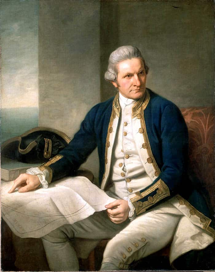
The famous navigator was born into the family of a poor Scottish farmhand, after 5 years of schooling he worked on a farm.
At the age of 18, he is hired as a cabin boy on his first ship. Thus begins his career as a sailor, which made James Cook famous.
He was at the head of 3 expeditions that explored the oceans. He paid much attention to cartography, the maps he compiled were used until the second half of the 19th century. He learned to deal with such a common disease in those days as scurvy.
He was known for his friendly attitude towards the indigenous inhabitants of the territories he explored, but died at the age of 50, killed by the natives of the Hawaiian Islands.
1. Christopher Columbus

A lot has been said about the life of this famous navigator. He was the first to cross the Atlantic Ocean and visited the Caribbean, the Sargasso Sea. He was the discoverer of Central and South America.
A native of their poor Genoese family, he received a good education. Dreaming of getting to India by a short sea route, Christopher Columbus makes a lot of efforts to implement their projects, but they all turn out to be inconclusive.
Queen Isabella, who agreed to pawn her jewels for a great idea, helped bring his dream to life.
4 expeditions were organized. Columbus died at the age of 55, the great significance of his discoveries was recognized much later, and during his lifetime the monopoly right to discover new lands was canceled for him, moreover, he was arrested and sent in shackles to Spain.


