Table mountain on whose territory. Table Mountain. What is the height of table mountain Vladikavkaz and how to get to it
Until recently, climbing Mount Stolovaya, which rises above the capital of North Ossetia and is clearly visible from many places in Ingushetia, was difficult for ordinary tourists, but after the Dzheyrakhsky district of Ingushetia canceled travel with passes and decided to develop tourism, any physically active person without special permission and without special tourist equipment can climb to the top of this mountain, from where magnificent views of the surroundings are revealed; and come down the same day. In this post, I will try to give a description of the route and advice, based on my little experience.
Route Description
1. Table Mountain is located on the border of North Ossetia and Ingushetia. There are several options for lifting it, incl. including from the north (Ossetian side), but all of them are designed for trained tourists, and only one option is simple, from the side of Ingushetia, from the rural settlement of Beini, along a well-marked road, which the Ingush call the "path of ancestors". Mass ascents of 100-300 people at a time have been carried out along it for a long time.If the beginning of the route is in Vladikavkaz, then you need to drive along the Georgian military road to the village of Beini, by a regular car it can take 40 minutes.

2. Turning left after the village of Chmi along the bridge across the Terek River leads to the entrance to the territory of the Dzheyrakhsky district of Ingushetia. This is a special area, it borders on Georgia, so there are 7 border outposts here, and at the checkpoint, beautifully decorated in the form of a tower arch, every person who enters is checked for a Russian passport (it is and only he is needed, no other special permits are required) .
By the way, thanks to border control (until 2013, entry into the district was only possible with passes issued by the FSB) and the fact that no more than 3 thousand inhabitants live in the district, the Dzheyrakhsky district was and is one of the most peaceful in the North Caucasus, there has never been there were terrorist attacks and major criminal incidents.

3. After the village of Dzheyrakh, the road leads first down, and then to the right, turning to Beini.

4. The previous photo, and this one was taken from the window of the room of the medical and health complex Armkhi, almost the entire scheme of climbing the mountain is visible from here:

The rise can be conditionally divided into five stages.
- The village of Beini (1580 meters) can be reached by any vehicle - on the maps this segment of the path is highlighted in red.
- From Beini to the foot of the mountain (serpentine) you can climb on an off-road vehicle - on the maps this segment of the path is highlighted in yellow. Not every tourist has an SUV, so most often this path is walked, it takes 2-3 hours (all walking routes are indicated in blue).
- The steepest and most difficult section of the road is the serpentine that leads to the saddle of the mountain. It can take about an hour and a half.
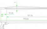
- After climbing the saddle, the path turns left and leads to the old pagan temple Myat-Seli (2560 meters above sea level), which can be reached in 40 minutes.
- Finally, from Myat-Seli to the top of the Dining Room (3003 meters) - half a kilometer of height, or two hours at a calm pace. From below, from the foot, this path is not visible.

6. View of Beini from the recreation center "Armkhi":

7. View of Myat-Seli from the recreation center "Armkhi":

8. The village of Beini is small, 80 people permanently live in it, after leaving the village - a tower complex, the road to the right leads to the foot of the mountain for ascent, straight to the towers, and to the left - a campground where you can park.

9. The campground was built at the beginning of the tourist season, there are four stationary tents, two toilets and showers are equipped. I can’t say whether the use of stationary tents is free (I heard information that the rental price per day is 750 rubles), but tourists can put their own nearby absolutely free of charge:

10-12. The road to the serpentine with a slight slope, it is not difficult, but long enough. On the descent, if desired, it can be reduced by moving in a straight line, but on the ascent this is undesirable, because. this will take the forces that will be required for the serpentine.

11. 
12. 
13. One and a half kilometers from Beini there is a spring, from which you need to stock up on water. Further, up to the top of the water will not be.

14-15. The serpentine path is well trodden, there are stones on it, so you need to be careful when descending so as not to accidentally stumble.


16. The serpentine leads to the saddle of the mountain, but to get to the top, you need to turn left when the path forks without climbing the saddle itself. If you continue straight ahead, you can go to an old iron booth, which was previously used for organizing mobile communications. Now the communication tower has been moved higher, to the mountain on the right, and the old booth is empty, there is nothing in it except garbage. In the most extreme case, you can spend the night in it, but I would not recommend it - our group of three people, who made an evening ascent, and climbed here after sunset, seeing the state of the booth, decided not to spend the night here, but to go further, despite the night time days.

17. From the saddle there is a smooth ascent with a slight slope to Myat-Seli, along one of the trodden paths. In one place on the trail there will be a barbed wire fence (it is made to restrict the movement of pets), you can try to either go around the fence from the side, or open the gate.

18. The pagan temple of Myat-Seli, many tourists end their ascent on this. The peculiarity of this place is a strong gusty wind.

19. The temple has dimensions of 6x4 meters, two sections, inside it you can spend the night. There are two small benches, a table, four niches in the walls, some tourists leave iron mugs, candles, spoons, unused plastic utensils here, so do not forget to check everything, and most importantly - do not be pigs and take all your own garbage with you, nothing not leaving here.


21. If you continue moving west from Myat-Seli, you can go down to a small lake. But to save energy, I recommend to bypass it and climb to the ruins of the second temple, Myater-Dala, which is 200 meters to the north. From this place, the villages of Sunzha, Ali-Yurt, Surkhakhi, Ekazhevo are already visible from the mountain, in the distance with binoculars or a good camera you can see Plievo, Karabulak, Ordzhonikidzevskaya, and also capture a few buildings of Magas (the view is blocked by rocks).

22. The ascent should be carried out along the high (northern) part of the plateau, it is generally not difficult. If you go down to the lower part of the plateau, you can see Jeirakh, Ezmi and the Georgian military road.

23. At an altitude of 2900 meters, it may be difficult to find a narrow passage between the rocks (2 meters wide), it should be sought along a trodden path.
At the very top there is an Internet connection tower, from here, in good weather, you can see Vladikavkaz and other settlements.

The descent along the same road as the ascent, usually takes one and a half to two times faster than the ascent.
The ascent to the top of the mountain and the descent takes all daylight hours. The best time for hiking is summer, in June the Canteen is freed from snow (in May it still lies), at this time the temperature during the day is from 18 to 30 degrees.If you are planning a day trip, then the ascent from Beini must begin at 6 o'clock in the morning. To do this, you can use one of the options:
1) come to Beini on your own vehicle very early in the morning, for this you need to leave Vladikavkaz at about 5 am.
2) come to Beini on your own vehicle the night before, put up a tent, spend the night, start climbing in the morning.
3) Arrive the day before in Dzheirakh by your own or public transport, rent a room at the LOK Armkhi (price 1,500 rubles per person), arrange with the locals in the evening for a ride to Beyni in the morning.
With you on the rise, without any doubt, be sure to take:
1) Sturdy sneakers, T-shirt, sweatshirt, raincoat (the weather in the mountains often changes).
2) Sun protection - goggles, and either clothing that covers the arms and neck (panama hat) to prevent sunburn, or sunscreen.
3) A supply of food for a picnic lunch, an empty plastic bottle to be filled with water at the spring (I recommend two liters per person per day)
4) Garbage bag, keep the mountains clean!
It is highly recommended to take:
1) Trekking boots instead of sneakers, they will be especially useful when descending.
2) Trekking poles, they are very unloading in the mountains. If you don’t have special tourist sticks with you, I recommend finding any wooden ones (we did just that).
3) If you (like me) have problems with your knees, you can put an elastic bandage on them in advance.
When climbing (up to the saddle), it is highly recommended not to try to "shorten" the path, i.e. go uphill straight, bypassing the zigzag path. Despite the apparent advantage in shortening the path, it wastes a lot of energy, I know several cases when physically active people who chose this type of climb did not reach it in the end, but the weaker ones walking along the path did.
If you plan to hike for more than a day with an overnight stay in the mountains, then I can give additional recommendations.
1) To carry out the rise either early in the morning (at 6 am, as per the one-day option), or in the evening, at 16-17 hours, i.e. at the time when the sun is at its lowest.
2) Accommodation for the night in Myat-Seli or within it, i.e. in a territory fenced from domestic animals (cows and horses graze on the mountain).
3) Climb to the top at about 2 pm, at which time there will be the best view of Vladikavkaz.
4) If you have several SIM cards, give preference to Beeline and Megafon when hiking. MTS is unstable.
5) It is recommended to warn the Beini administration about your trip. Do not go alone, mountains of mistakes do not forgive.
You should take with you:
1) A set of clothes and sleeping bags that keep the temperature at 0 degrees - at an altitude of 2500 this temperature is at night even in summer.
2) A tent, it will help even if you spend the night in Myat-Seli, because the temple has no doors and is blown through (despite the fact that the entrance can be closed with a table, and the second window is hung with plastic wrap)
3) Dry fuel. There is no wood at the top, or it may be damp, so it is better to buy a special set of "dry firewood" in the store.
4) Naturally, you also need to take a kettle, a bowl, a spoon, a fork and a good knife)
5) Headlamp, and, if possible, other means of illumination, such as chemical light sources (glow sticks).
6) Seat and foam mat, it makes life easier)
7) Medical kit.
A few words about the situation in the region. Dzheyrakh, as I wrote, was previously a closed border area, there were no terrorist attacks, there is little population, so the likelihood of getting into a criminal situation, in my opinion, is minimal (in any case, orders of magnitude less than, for example, in Moscow). Most of the Ingush people are very hospitable, they like to make friends and invite home for tea) I was in the mountains for a total of 10 days, and almost all the time I explored the mountains on my own, i.e. alone, hung with expensive photographic equipment and without security), no troubles happened to me.
Actually, that's all for now :)
This entry as far as possible, I will update and supplement, I will be glad to clarifications and questions!
I will post a photo report from our trip to the Canteen in June within a month.
Happy hiking! :)
Table Mountain (Vladikavkaz, Russia) - detailed description, location, reviews, photo and video.
- Hot tours in Russia
Previous photo Next photo
Table Mountain is depicted on the coat of arms of Vladikavkaz and is perfectly visible from the city. It is also present on the coat of arms of the Republic of Ingushetia, as it stands on its border with North Ossetia-Alania. This is one of the largest peaks of the Rocky Range of the Caucasus Mountains, its height is about 3000 m.
Table mountains or tabletop mountains are considered the oldest geological formations. Their peculiarity is a flat top and steep slopes, this form really resembles a table.
The Caucasian Table Mountain has always been revered by local residents, it was an analogue of the Greek Olympus, that is, it was considered the place of residence of the gods. The ruins of many sanctuaries, mainly from the 10th-18th centuries, have been preserved on the mountain. The oldest of them, Myat-Seli, dates back to the 4th-8th centuries.
Hiking trails are laid on the mountain, climbing them takes several hours, but does not require special physical training and equipment. The most convenient of them starts from the side of Ingushetia and is called the “path of the ancestors”, mass ascents of up to 300 people are organized along it at the same time.
Practical Information
Address: Republic of North Ossetia - Alania, Prigorodny district. GPS coordinates: 42.868331; 44.703331.
The most convenient way to get to Table Mountain is by car, the road from Vladikavkaz will take about 40 minutes. You need to go along the A-161 highway (Georgian Military Highway), then turn onto R-109 and move to the village of Beini, where the road ends.
On the way, you will meet several checkpoints where only a Russian passport is checked.
Table Mountain (2993 m)
Table Mountain is one of the largest in the Rocky Range. It is located south of the city of Vladikavkaz and is clearly visible from almost any of its districts. The distance to it from the city is about 15 kilometers. In clear weather, the entire massif is clearly visible, stretching from west to east. The mountain is the eastern (extreme) in the Rocky Range on the territory of North Ossetia. Geographically, it belongs to the Tseylam Range (Ingush Republic). From the east, it is limited by a deep depression - the Ger-chech pass, in the west - by the Baltic Gorge, through which the Terek River flows. To the south of it lies the valley of the Armkhi River (Ingush Republic).
The massif has two pronounced peaks, between which several large gendarmes rise. The eastern peak (2993 m) is the main one. It looks like a huge flat table overgrown with grass. It was she who gave the name to the mountain - the Dining Room. From the main peak, a long ridge departs in a smooth arc to the northwest, steeply falling into the valley of the Terek River. It is called "Lion's Mane". To the south of it stretches the Vagai-choch gorge. Here steep walls fall
peaks cut by narrow couloirs. Steep ridges descend to the north, covered in the upper part with grass, below - overgrown with dense forest and shrubs. The western peak (2703 m) is separated from the main peak by a deep narrow bridge. It has the appearance of a large cone with rocky ribs, evenly falling in all directions. It is called the "Head" of the Dining Room.
The Ossetians call the mountain Dining room Madkhokh (Mother Mountain), and the Ingush - Mat Lam, which has the same translation. On the eastern ridge, not far from the main peak, there is an ancient sanctuary. The legend associated with this mountain is curious. A long time ago, when Cyclopes were still living in caves and dense forests, one of these monsters got into the kingdom, located north of the present Table Mountain, subjugated him and imposed tribute: every year on the same day he was supposed to bring the most beautiful seventeen-year-old girl . At the same hour, the monster appeared and, ignoring the heart-rending cries of the inhabitants, carried away the girl in order to eat her later. This went on for many years. But then the people found out the secret of the monster: if the most beautiful girl sacrifices herself, she herself runs out to meet him and throws herself into the mouth, the monster will die, and the people will get rid of the humiliating and heavy tribute. That year, the beautiful princess turned seventeen. From early childhood, her father kept her locked up, fearing that she might become a victim of a bloodthirsty cyclops. No matter how the father concealed the truth from his daughter, she still found out about the monster and about the misfortune that befell the people, and about the fact that she is the most beautiful of her peers in their kingdom. The fateful day has come. Sobbing crowds went to the plain to give the next victim to the monster. And among them was hiding the princess, who secretly escaped from the castle. When the monster approached the people, a princess of indescribable beauty broke out of the crowd and threw herself into his mouth. There was a terrible roar, flames broke out, and everything was shrouded in smoke. When the smoke cleared, a mountain appeared before the astonished people - a beautiful princess lying on her deathbed. At this time, the beloved of the princess, a brave young shepherd named Kazbek, was tending sheep high in the mountains. Hearing the noise, he looked down from the top and saw how the princess threw herself into the jaws of the monster. Unable to bear the death of his beloved, he rushed down from the cliff, having managed to shout that it would be better for him to turn into a mountain. And immediately the young shepherd turned into a two-humped mountain, rising high above all the mountains to guard the peace of his beloved.
What was the basis for such a legend? Most likely - the outline of the mountain. Looking closely at the contours of the mountain (it is more convenient to observe from the northern part of the city in clear weather, immediately after sunset), you can see a head with loose braids, a fairly clear outline of the face, chest, abdomen, and legs. On the coat of arms of the city of Vladikavkaz, created in 1873, the silhouette of the Table Mountain is one of the components.
A number of routes lead to the top of the mountain. Some of them are popular. Repeatedly, mass ascents were made along them, usually dedicated to some anniversaries. The dining room is replete with numerous grottoes and caves. One of them - Stalactite - is located in the northern spurs of the mountain.
Route 6 to the stalactite cave(Scheme 2, compiled based on the materials of S. F. Grigorovich, 1960)
The path from Vladikavkaz along the VGD after 11 kilometers leads to a lime plant (located near the road, now abandoned). Further traffic goes south 150 meters to the suspension bridge across the Terek. Behind the bridge, a path begins, which leads east along the floodplain of the Terek. From the coastal terrace, where the path leads, the houses and gardens of the village are clearly visible. Chernorechensky. It can be reached by regular bus from Vladikavkaz.
Crossing the village, climbing to the eastern bank of a deep rocky gully, the path, following to the east, leads to the forest. At the edge of the forest lies the second shallow beam, overgrown with shrubs. A road runs along the western bank of the beam to the south, turning east and entering the forest. It follows a descent to a small river. The road continues along the left bank, then passes to the right bank, leaves the river, passes through a young forest with a direction to the southeast. Soon the forest parted and a beautiful clearing appeared. Ahead, the rocky peaks of Table Mountain jut out to the south. From here you can clearly see the gorge separating the peaks of the mountain.
The forest road goes south. The movement continues along a wide path that looks like a forest clearing. The path gradually deviates to the south and leads to a small stream. Behind the stream exit to the meadow. In the midst of a young forest on the southeastern outskirts of the clearing stands a tall beech with a forked trunk. Here it is advisable to arrange a short rest, stock up on water. To the right of the beech, 50 meters away in a beam there is a spring.
The path goes to the east. The forest is changing. Old beeches rise high up. The slopes of the mountains are cut by deep beams. Piles of yellow leaves and fallen trees are visible everywhere.
After 1.5 kilometers, having crossed the gully, one should turn south to a wide clearing seen on the mountainside. The cave is close, only 500 meters, but the climb to it is steep. The glade was overgrown with ferns and weeds almost as tall as a man. Thick layers of limestone are visible on both sides. The glade is surrounded by old maples and lindens. The eastern part of the clearing rests on a rocky ledge. At its foot you can see the entrance to the cave.
From s. Chernorechensky to the cave 3 hours walk.
The cave is 34 meters long, 25 meters wide and over 10 meters high. This is a wonderful creation of nature. Lime streaks-stalactites hang from the ceiling of the cave like icicles, and pillars of stalagmites rise from the bottom. The cave is cold and dark. Under the light of lanterns and candles, stalactites and stalagmites take on fantastic shapes.
Travel time with a return to Vladikavkaz takes 8-9 hours.
Route 7 to the village of Beini from Vladikavkaz(scheme 2)
The village of Beini is located in the gorge of the river. Armkhi. From Vladikavkaz to the gorge of the river. Armkhi according to IOP 23 kilometers.
The path starts from the former camp site, located on the corner of the streets of General I. A. Pliev and Costa Avenue. The motorway passes between the slender pines of the forest park, which houses rest houses, gardening farms of the townspeople. At the intersection with the bypass road, a cable car goes up from the motel, leading to the top of Bald Mountain (now it does not work). Behind the traffic police post, the Georgian Military Road begins. The steep slopes of the surrounding mountains are covered with dense forest. Below is a wide floodplain of the Terek, into which the spurs of Izvestkovaya Mountain fall.
After 20 minutes, behind the fork on p. Redant shows a small abandoned lime plant. Sheer cliffs rise above it, mastered by climbers and climbers who conduct training and competitions here.
On the right bank of the Terek, the massif of Table Mountain opens wide. Can be seen from p. Balta, that its peaks surprisingly resemble the famous Ushba in miniature.
Leaving the development of Kavdolomit on the left, passing the villages of Balta and Chmi, turning left, the road crosses the bridge over the Terek, leading to the Ezminskaya hydroelectric power station. Here it splits in two. A narrow dirt road turns left into a small gorge leading to the Table Mountain massif. A wide road covered with gravel leads to the beginning of the Dzheyrakh gorge. In front of the bridge across the turbulent Armkhi River, a monument to the hero-revolutionary Ingush Akhriev was erected. From Vladikavkaz to the fork is 21 kilometers.
The height mark is 920 meters. Nature is changing dramatically, turning into a steppe. The sharp contrast in the appearance of the slopes of the Rocky and Side Ranges is striking. In this place, the first, constantly dried up by the rays of the sun, is covered with steppe vegetation. Prickly bushes - astragalus - are visible everywhere on the slopes. On Bokovoe, facing north, a dense forest grows, noisy streams run. The road rises steeply above the Armkhi River, leading to the village. Dzheyrakh. (Ingush Republic). Passing the village, the road descends into the valley of the river. Armkhi along the layers of destroyed shale.
The valley of the Armkhi River, the largest tributary of the upper Terek, stretches between two ridges: Skalisty and Bokovoy from west to east. Because of this location, there is a lot of sun. The village of Beini is located on the opposite slope at an altitude of 1540 meters above sea level. On the outskirts, a dilapidated tower has been preserved. On the slopes of the surrounding mountains, the remains of Ingush villages are visible.
To s. Beini can also be driven from with. Furtog on the right terrace of the Armkhi River - 10 kilometers from the VGD. Before climbing to the top of Table Mountain near the village, you should make an overnight stay, there is water.
Route 8 to Mount Table from the south of the village of Beini(scheme 2, 4; photo 2)
The ascent starts early in the morning. The ascent passes along the path leading to the saddle of the ridge. At the spring you need to stock up on water. From the saddle, the movement continues along fragrant, dotted with mountain flowers in early summer, meadows to the north-west, and then to the north, focusing on the table-top of the mountain visible in front. Along the way, the karst forms of the mountain attract attention: grottoes, gullies. Bypassing the ancient sanctuary, there is an ascent to the top table. The path goes through the meadows of the table to its western raised edge, which is the top. Here, a tour is made of stones. From the saddle to the top 5 kilometers. The air at the top is clean and fresh, the bright rays of the sun are burning. The buildings of the city of Vladikavkaz and the villages scattered across the plain are clearly visible, from here they seem like toys. Kazbek rises in the south. From it, to the west and east, the mountains of the Lateral Range stretch in an endless ridge. In clear weather, the blue peak of Elbrus is visible in the distance. Here, at an altitude of 3000 meters, there is an unusual silence.
The descent follows the path of the ascent or Route 13.
Climbing with return to the village. Beini occupies a full daylight hours. The route is long, but not technically difficult. Climbing participants are required to have average physical fitness and basic skills of movement in the mountains. It is necessary to have tourist clothes, a supply of food for two days, bivouac equipment.
Route 9 to Mount Stolovaya along the southern ridge from the museum-estate of Akhriev(scheme 2, 4; fig. 1; photo 2)
The entrance from Vladikavkaz to the fork in the road at the Ezminskaya HPP is described in Route 7.
From the fork, turn left on a dirt road into the gorge leading to the Table Mountain massif from the west. After 1 hour of walking, at the end of the gorge, the road turns right up and leads to the museum-estate of Akhriev, located on a wide grassy southwestern ridge. From here you can see both peaks of Table Mountain with two large gendarmes between them. The path goes up a wide steep rise of the ridge, overgrown with sparse forest, gradually taking a southerly direction. Above the middle part, the ridge flattens out, the forest ends. Here it is desirable to make a stop for rest. Top table nearby. A steep grassy slope leads to a rocky ridge. On the simple rocks of the ridge climb to the top table. The rocks abound with niches and grottoes. To the west, the table ends with sheer rock walls. On wide meadows with gentle ups the movement to the top.
From the museum-estate 4-5 hours.
Descent along the ascent path.
The route along the southern ridge is steep, but not technically difficult. Requires climbing participants to have good physical fitness, basic skills of movement in the mountains, tourist clothing, food and drink. In summer, there is no water on the route, in the off-season and in winter there is snow. It is possible to extend the route by going down from the summit to the north to the VGD along Route 13-10.
Route 10 in the Vagaychoch Gorge (Bear Gorge)(scheme 2, 4; photo 3)
The picturesque Vagaychoch Gorge stretches between the "Lion's Mane" in the north and the western ridge of the "Head" of the Dining Room in the south. It was formed in the place of rock bending as a result of a tectonic crack.
The entrance to the gorge starts from the 16th kilometer of the VGD. Having passed the bridge over the Terek, the buildings of "Kavdolomita" the road, covered with white dolomite dust, rises in steep zigzags into the gorge. In its middle part, it flattens out. The gorge narrows. On the edge of a large quarry are workers' houses. In the late 1970s, there was a large clearing here, through which a stream with clean water flowed. It was a traditional gathering place and a halt for participants climbing to the top. Further the path goes through a dense low forest overgrown with shrubs. There is no visibility, only the steep sides of the gorge rise at the top. Gradually, the forest thins out, the gorge narrows, turning into a canyon. A small cave is visible at the top of the sheer cliff. Cool and gloomy. Increasingly, stones and boulders come across on the path, and, finally, it becomes completely rocky. The gorge ends with a fork under high cliffs. To the right there is a narrow steep gorge, leading to a small jumper between the gendarme and the "Head" of the Dining Room. On the left stretches the northwestern ridge "Lion's Mane".
The length of the Vagaychoch gorge is 10-12 kilometers, about 3 hours of walking.
Route 11 to the "Lion's Mane" from the south
The exit to the central part of the "Lion's Mane" passes along a path that rises steeply along a grassy slope. There are a lot of “live” stones on the trail, and when it rains, it becomes slippery. As you climb, make frequent rest stops. The ridge is overgrown with frequent dwarf birches. The trail goes up smoothly. The forest parted and the northern part of the massif opens ahead with steep rocky walls cut through by narrow corridors. In a wide depression of the ridge in front of the rocks, it is a convenient place for a bivouac and rest. There is no water, in the off-season and in winter there is snow.
About 3 hours from the fork.
The route requires participants to have good physical fitness, tourist clothing, food and drink. Takes a full daylight hours with the return to IOP.
Route 12 to the Lion's Mane from the north(scheme 2; fig. 2; photo 3, description based on materials by B. M. Beroev)
Entrance to the village Turk from Vladikavkaz by car takes 30 minutes. From the right coastal terrace of the Terek at the extreme southern houses of the village. Turk should enter the forest. Near a small river, turn south and move along its left bank along a forest dirt road, which gradually turns into a path. The first 1-1.5 kilometers of the ascent is negligible. Then the path begins to climb steeply up among the plane tree forest, in some places with slight zigzags. After 1.5 hours of movement through the forest, there is an exit to a small jumper, from which there is an ascent in the middle of the forest along the slope to the "Lion's Mane". After another 1.5 kilometers, the forest ends, and then there are animal trails laid in raspberry thickets to the very ridge.
The descent takes place along the path of the ascent, or, having descended along the ridge for 1.5 kilometers, parallel to the ascent route. It is possible to descend to the Vagaychoch gorge along the Route. eleven.
The length of the route is 14-15 kilometers, the duration is 6-7 hours.
Route 13 to Table Mountain from the north (1B)(scheme 2, 4; fig. 2; photo 3)
The ascent to the "Lion's Mane" is described in Routes 10-12.
From a wide drop in the ridge in front of the rocks, move up or around easy rocks. The steepness of the ridge reaches 40-45 degrees. After 2.5 hours approach under a steep (up to 55°) wide couloir, about 60 meters long. Here you need insurance, hanging railings. In the off-season and in winter, snow lies in the couloir, and ice is possible in the upper part. Sheer cliffs all around.
The couloir brings the tops to the table. At 100 meters from the edge of the table of stones, the summit tour is built.
The route from the VGD to the summit takes 6-7 hours. It requires climbing participants to have the skills of movement in the mountains, tourist clothing and equipment (ice axes, rope), food and drink, bivouac equipment.
Route 14 to Table Mountain from the west (2 ks)(scheme 4; fig. 2; photo 3)
On April 20-21, 1991, a group of climbers from North Ossetia tried to pass the route from the side of the "Head" of the Dining Room, passing the latter by a traverse from the south and descending to the jumper in front of the 1st gendarme. Members of the group: Yu. V. Levkovsky, I. O. Afanasiev, I. O. Bondarenko, A. P. Glazov. An approximate description is given.
The approach along the Vagaychoch gorge to the fork is described in Route 10. Turning to the right, climb along the left side of a narrow steep gorge, above the middle part turning into a couloir. In the off-season, snow lies in it, the slopes are saturated with water. The couloir is clearly visible from Vladikavkaz. After 2-3 hours, exit to a small jumper between the eastern ridge of the "Head" of the Dining Room and the 1st gendarme. To the south, the lintel breaks off with steep walls. To the left-up in the ridge leading to the main peak, there are rocks of the "ram's foreheads" type, about 2-3 st. Hook insurance, railings are required. The length of the rocks is about 100 meters, the steepness is 45-50 degrees. The rocks lead to a wide steep scree shelf, bypassing the 1st gendarme on the left. The length of the shelf is 150 meters. The regiment leads to the western ridge behind the 1st gendarme. Then follows the movement along the simple western ridge through the 2nd gendarme to the rocks on the western side of the summit table. One of the short steep couloirs leads to the summit.
The duration of the route is 2 days with an overnight stay on the western ridge or at the top. Equipment - ice axes, ropes, rock hooks.
Route 15 to the "Head" of the Canteen along the eastern ridge (1A)(scheme 4: fig. 2; photo 3).
The ascent to the lintel between the eastern ridge of the "Head" of the Canteen and the 1st gendarme is described in Route 14.
At 40-60 meters from the lintel, turn right and go out onto a narrow steep grassy-rocky ledge 40 meters long. Further movement along a steep grassy slope with access to the eastern ridge. At first, 20-30 meters along the simple rocks of the eastern gentle ridge, then 150-200 meters along a large scree with large boulders to a large gendarme, which is bypassed on the right along a steep grassy slope (in the off-season and in winter there is snow, increased avalanche danger,
key section of the route, belay through an ice ax, it is possible to hang a railing). Climb to the top along the ridge after 100 meters.
From the fork at the end of the Vagaychoch gorge 5-6 hours.
The route requires climbing participants to have knowledge and skills of initial climbing training. It is necessary to have ice axes, a rope.
Route 16, to the "Head" of the Dining Room from the south (1B), option 1(scheme 4)
The path to the fork in the road at the Ezminskaya HPP is described in Route 7.
From the fork, turn left on a dirt road into the gorge leading to the Table Mountain massif from the west. After 1 hour of walking, at the end of the gorge, the road turns right up and leads to the museum-estate of Akhriev, located on a wide grassy southwestern ridge.
The route continues along the gorge, which narrows, turning into a canyon with steep rocky and grassy slopes. After 1 hour there is an approach under the rocky step blocking the gorge. An eight-meter metal staircase hangs from above. Climbing the stairs and again moving along the bottom of the gorge. Gradually, the gorge widens, the slopes lose their height, become flatter. The gorge turns into a large beam. Ahead opens rocky massif of Table Mountain. To the left, steep grassy slopes lead to the southern ridge of the "Head" of the Dining Room.
The duration of the route from the fork in the road at the Ezminskaya HPP is 4-5 hours.
Route 17, to the "Head" of the Dining Room from the south (1B), option 2(scheme 4)
At the end of the gorge, from the turn of the road to the museum-estate of Akhriev, turning left, climb 250-300 meters along a steep shallow scree under the rocks. Here you need to find the beginning of the path, which goes among the rocks of the right side of the gorge. The first approach to the route passes along the bottom of this gorge. Winding among the rocks, gradually gaining height, the path leads under the grassy slopes of the eastern side of the southern ridge of the "Head" of the Dining Room. On steep (up to 45 degrees) grassy slopes climb to the southern ridge. On the left is a large sloping peak on which the repeater stands. This is Mount Dikdu (2196 m). From the saddle of the southern ridge there is a good view in all directions. A panorama of the Table Mountain massif opens.
The travel time of the routes is full daylight hours. Both approaches require participants to have average physical fitness, basic mountain mobility skills, hiking clothing, food and drink. Some difficulty is climbing the metal ladder in the gorge, as well as the steep grassy slopes at the exit to the southern ridge.
Route 18, to the "Head" of the Dining Room from the south (1A)(scheme 4; fig. 1; photo 3)
The path to the top goes along a wide southern ridge, overgrown with grass, leading to the beginning of a scree couloir. Ascent along the steep scree of the couloir, then along its right side under the rocks. In the middle part of the couloir, turning to the right, movement along a narrow steep rocky-grass ledge 50 meters long, at the end of which there is an unpleasant psychological section with a protruding rock. Further to the left up a steep (up to 50 degrees) grassy chute to the ridge. On simple rocks 1-2 k. ate. climb to the top.
From the fork in the road at the Ezminskaya HPP 7-8 hours.
The route requires climbing participants to have knowledge and skills of initial climbing training. It is necessary to have ice axes, a rope. There is no water on the route.
From the west, a rocky couloir leads to the top of the "Head" of the Canteen. Passed by R.P. Proskuryakov and rated as 2A class.
To Mount Dining Room from the south
The ascent starts early in the morning. The ascent passes along the path leading to the saddle of the ridge. At the spring you need to stock up on water.
From the saddle, the movement continues along fragrant, dotted with mountain flowers at the beginning of summer, meadows to the north-west, and then to the north, focusing on the front mountaintop table. Along the way, the karst forms of the mountain attract attention: grottoes, gullies.
Bypassing the ancient sanctuary, there is an ascent to the top table. The path goes through the meadows of the table to its western raised edge, which is the top. Here, a tour is made of stones. From the saddle to the top 5 kilometers. The air at the top is clean and fresh, the bright rays of the sun are burning. The buildings of the city of Vladikavkaz and the villages scattered across the plain are clearly visible, from here they seem like toys. Kazbek rises in the south. From it to the west and east stretch in an endless ridge side range mountains. In clear weather, the blue peak of Elbrus is visible in the distance. Here, at an altitude of 3000 meters, there is an unusual silence. The descent follows the path of the ascent.
Climbing with return to the village. Beini occupies the entire daylight hours. The route is quite long, but technically not very difficult. Climbing participants must have average physical fitness and initial skills in moving around the mountains. It is necessary to have tourist clothes, a supply of food for two days, bivouac equipment.
The next, one of the popular routes to the top of Table Mountain, runs along the southern ridge.
To Mount Table along the southern ridge
 Entrance from the city of Vladikavkaz to the fork in the road at the Ezminskaya hydroelectric power station.
 From the fork - turn left along the dirt road into the gorge leading to the massif Table Mountain from the west. After 1 hour of walking, at the end of the gorge, the road turns right up and leads to the museum-estate of Akhriev, located on a wide grassy southwestern ridge. From here both peaks of Table Mountain are clearly visible with two large gendarmes between them.
The path goes up a wide steep rise of the ridge, overgrown with sparse forest, gradually taking a southerly direction. Above the middle part, the ridge flattens out, the forest ends. Here it is desirable to make a stop for rest. Top table nearby. A steep grassy slope leads to a rocky ridge. On the simple rocks of the ridge climb to the top table. The rocks abound with niches and grottoes. To the west, the table ends with sheer rock walls. On wide meadows with gentle ups the movement to the top.
From the museum-estate 4-5 hours. Descent along the ascent path.
South ridge route cool, but not technically difficult. Requires climbing participants to have good physical fitness, basic skills of movement in the mountains, tourist clothing, food and drink. In summer, there is no water on the route, in the off-season and in winter there is snow.
So, YESTERDAY I WAS AT THE TOP OF THE MESA MOUNTAIN.
Another dream has come true, I am happy, and all this is thanks to Ilez Matiev, who this time has become the kind magician who makes dreams come true.
Probably, everyone knows that climbing Myatloam (as Table Mountain is called in Ingush) was my big dream for the last two years. Last year, I did not plan to implement it, but at some point it seemed to me that there was a chance ... but it was not that chance, and the dream did not come true. I was very upset then, although I understood that at that moment it would be wrong to climb the mountain, but the desire was too great.
I have a vile character, and if I want something, then I find any ways to achieve what I want, and this is done on the sly, so that someone does not frighten off the opportunity that has turned up.
On the day when last year I couldn't climb the Canteen, I went to Vladikavkaz and photographed it from there. This photo has a title: "The Mountain I Wasn't Allowed to Climb".
When I realized that the ascent plan was taking on real features, I hoped that from the top I would be able to photograph Vladikavkaz and thus show everyone my tongue, they say, here I am, but the idea with the tongue failed: at the top we were above the clouds, and Vladikavkaz, of course, is under them.
However, here
The idea of climbing the mountain lived in me, grew and multiplied, but I could not find a solution on how to make everything happen until I found Ilez's profile on FB, where there were photos from the Canteen and an invitation to everyone who wanted to visit it climb up. I plucked up the audacity and wrote, to which I received an answer: yes, come, let's try.
Since then, next to the dream began to live and hope.
After a trip to Isa Kodzoev, Ilez promised me the ascent, and last week he clicked a call on FB to find more people. We hoped that there would be other girls besides me, and they were. However, at the time of the direct gathering of those who wanted to go to the bus station to go to the foot of Myatloam, only Renada and I were among the women, who, unfortunately, also did not rise and remained below. Thus, 17 guys and I climbed the mountain. Cool company, considering that all the hipish with the collection of the team was started only so that I would not be the only woman. But I guess it's my destiny. As one of my good friends says: "Lenka is always at the head of the men's team."
We started the ascent from the village of Beini, however, unlike the plan that was described timag82
a couple of years ago, we went off the road. Due to the fact that the start of the ascent was delayed for quite a decent time, our leader decided to "cut off" and we went through the initial part of the ascent on the grass and at a very high speed. This was, perhaps, the main reason that, when we got on the trail, I felt dizzy, stuffed up my ears, and I thought with horror that I would have to go down. But, thank God, there were good people nearby. I was handed a stick, given water to drink, and told to walk at my own pace. And I went.
The first stage of the way to the spring turned out to be the most difficult. But a little rest, a cucumber and an interesting story that Ilez told, restored strength, and then it became much easier. The old-timers surrounding me, who had already repeatedly gone upstairs, frightened me with serpentine. And it was at the beginning of the serpentine that I found myself alone. The first part of the group was already far ahead, and those lagging behind were still far behind. I was a little scared, but since there is only one path, and it is impossible to get lost, I went.
The serpentine turned out to be a difficult, but quite surmountable obstacle. It also gave me strength that I was alone. I have known for a long time that it is easier for me to do all the difficult things alone, since I don’t have to waste energy on maintaining unnecessary conversations and relationships. You can go at your own pace, make stops convenient for you and not think about others. You are on your own and that's good. Slowly, I reached the top, by that time an incoming cloud had sunk into the milk. It became cool and light. Then the path was quite flat, I felt very good.
Walking rather briskly, in the distance on a hill, I saw the figure of a man who, like an eagle, peered into the distance. The first thought was that they were waiting for me, but as I got closer, it became clear that they were not waiting for me, but this eagle was well known to me. He, too, apparently recognized me (of course, last year I was in the same pants). Timur was waiting for his comrades who had come down for water. I was amused by the phrase he met me with: "We meet in unexpected places." And for some reason it flashed through me: "The meeting place cannot be changed." (How differently people see the same situation.)
He saw me off for a bit, and then my companions were already waiting for me at a halt. While we were having a simple lunch, the phrase “eight girls, one me” was spinning in my head, although in reality everything looked completely different: 12 guys and one girl ... But in general, the meaning is clear. Ilez remembered the movie "The Thirteenth Warrior".
I was treated to homemade bread. It's very tasty, I must say. Although even sandwiches with cheese at that moment seemed like an overseas delicacy.
Then there was the Mint-Seli Temple, where the participants of the photo-expedition settled down for lunch. It's fun to see people you know virtually all in one place. In addition to Timur, there was a photographer from Pyatigorsk, a Chechen photographer Abdullah Bersaev and several other people who were not familiar to me. Apparently due to the fact that I was already a little tired, and also because of the large number of people around me, Myat-Seli did not cause much joy. Somehow, our meeting passed. But this is also my virtual acquaintance. How many photos I saw with his participation.
We moved on. Here are the horses by the lake. And a green meadow. All that I so often see in the photographs of Timur and Abdullah.

We moved on: our goal is the top of the Canteen. Ilez proposes a plan that I did not like: not to take a detour along the gentle road, but straight ahead, going down and up the steep slope. Now, having already assessed the situation from the outside, I understand that it was right: from the gentle slope you can’t see the stone arch, which is not in any photo from the Dining Room, except for the photos of Ilez. But at that moment it was difficult for me, I could hardly move my legs, the stick, which, in general, is designed to help in the campaign, was already beginning to infuriate, because it also needs strength to move it. But still climb to the top.
I found myself in a trap: to spit on everything and go back is impossible: I am alone, but there is no strength to go forward. I am grateful to my two companions, who at that moment were always nearby. Ilez, who quickly climbed up, did not seem to doubt my strength and shouted for me to climb faster. Despite everything, we climbed. Unfortunately, there were clouds below, obscuring the view of the cities below. But this almost did not overshadow the joy that we still could. The respite at the top turned out to be short-lived: we had to return, too long a rise delayed us.

The descent along the gentle slope was much easier than the ascent, and we went faster, but on the serpentine I slowed down, the stones that covered the path left from under my feet, and I had to walk rather slowly so as not to fall. Gradually evening came, it began to get dark and it began to rain. We walked, the road did not end. Almost all of my companions descended quickly, Ilez and a few other people remained with me. Ilez picked thyme along the way, so we went down at about the same slow pace.
The most amazing thing happened at the end of the journey. When it got completely dark, the clouds dispersed and half of the moon came out, which illuminated our path. Beini looked mystical in the moonlight: the stone towers on the right, like ghosts from the past.
For me it turned out unexpected immediately after the descent, the desire to go up there again. The legs came unstuck from the body and there was a desire to unfasten them and hang them to rest, but the rest of the creature wanted back.
I was afraid that this morning my legs would hurt. Surprisingly, everything is not so bad: the muscles are only slightly felt and slightly disturb the knees (yesterday, on the last steep climb, it seemed to me that I pulled my knees, they could hardly bend and refused to pull the body up).
The result is this:
- cucumbers when climbing a mountain are the coolest product, they helped me a lot, each eaten cucumber added strength to me (and at the same time made my backpack lighter);
- you need to go at your own pace, without adjusting to others;
- I was once again convinced that one is always easier;
- today I feel great and am the happiest person on earth;
- I want to climb Myatloam again.
I was scared that climbing the mountain is difficult, but I want to say that the realization of dreams cannot be easy. As practice shows, I am not very afraid of physical exertion, I have other troubles.
Since the end of April, I have been worried about whether this trip will take place, I was sure that I could and that I would like it, I was not mistaken. Now we need to find another dream, and I am very afraid that it will also be connected with mountainous Ingushetia.