Oz big current. Research of the Yakut Lake Big Toko brought sensations
January 21st, 2013 08:47 am
 Photo by Irina Karman.

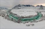
Bolshoye Toko is the largest lake within the Stanovoy Range with a surface area of 82.6 km² and is a tectonic depression treated by a glacier. It has the shape of a rounded, northwardly elongated reservoir with small bays of glacial origin. The lake is located on the Tokinskoye Plateau with absolute heights of 950-1100 m and a total area of more than 10 thousand km², with coordinates 57 ° 20 "north latitude and 132 ° 40" east longitude. The plateau, also called the Tokinskaya basin, is bordered by the Tokinsky Stanovik ridge in the south and southeast, the Nizhne-Gonamsky ridge in the north, the Ningansky ridge in the west, and the Uchur-Idyumsky ridge in the east. The lake is located in the south of the basin and is limited by a system of shafts of terminal moraines, which are the result of the active activity of glaciers of the Quaternary period, descending from the slopes of the Stanovoy Range during the glaciations. The complex of moraines forming the coast rises above the lake level to a height of up to 100 m and reaches a width of 2-3 km. From the outside, this complex is represented by a steep, finite moraine shaft, with ridges up to 10-15 m high. The ridges are composed of large rounded boulders and stone blocks untreated by the glacier. At a distance of two kilometers to the south, there is Lake Maloe Toko (area 2.5 km²), which is connected by a channel with the only significant tributary of Lake Bolshoe Toko - the Utuk River. All flow occurs through the Mulam River, the left tributary of the Idyum.
The height of the water's edge, equal to 903 m, corresponds to the transition zone from the mountainous middle taiga forests to the zone of forest-tundra forests. The lake is located in an area of widespread permafrost, the thickness of which in this area reaches 30 m, the depth of winter freezing and thawing ranges from 0.3 to 4 m. The duration of winter in the area is 7/7.5 months, the average temperature is -30 ° C /-32°С. The maximum precipitation falls on the summer period, the average temperature of the calendar summer is +17°С/+19°С. The lake area is seismically active, strong earthquakes in the area may have been associated with the development and melting of glaciers during periods of glaciation. During the Quaternary period, volcanic or large geothermal eruptions may also have taken place in the vicinity of the lake.
The coast is covered with larch forest, where elk, wild deer, brown bear, sable, birds and waterfowl can be found. Taimen, lenok, grayling, whitefish, perch and pike are found in the lake. Due to the large depth of the reservoir, its water is highly transparent.
Federal District: FEFD
Region: The Republic of Sakha (Yakutia)
Pond type: lakes
Fish: dace, perch, roach, grayling, pike, char, lenok, whitefish, taimen
Types of fishing: float fishing, bottom fishing, spinning, fly fishing, live bait fishing, winter fishing, other types of fishing
Length: 15 km
Width: 7.7 km
Max Depth: 80 m
Square: 82.6 km²
GIMS: Ministry of Emergency Situations in the Republic of Sakha (Yakutia)
Status: free
Big Toko is a large lake in the Aldan Highlands, in the Neryungri region of the Republic of Sakha (Yakutia), on its border with the Khabarovsk Territory.
The area of the water mirror is 82.6 km². The lake is 15 km long and 7.7 km wide. The average depth is 42 m, the largest is about 80 m. Due to the large depth of the reservoir, its water is highly transparent. The volume of enclosed water is 3.47 km³. Bolshoye Toko is the 14th lake in Yakutia and the 143rd lake in Russia in terms of water surface area.
Bolshoye Toko is the largest lake within the Stanovoy Ridge. The lake has a glacial-tectonic origin and is a tectonic depression processed by a glacier. It is characterized by an oval shape, elongated from the north-northeast to the south-southwest. It has several small bays of glacial origin. The coastline is slightly indented. The shores are gentle. The reservoir is surrounded by a system of moraines, which are the result of the active activity of glaciers of the Quaternary period, descending from the slopes of the Stanovoy Range during the glaciations. The complex of moraines forming the coast rises 60-100 m above the lake level and reaches a total width of 2-3 km. From the outside, this complex is represented by a steep moraine ridge with ridges up to 10-15 m high. The ridges are composed of large rounded boulders and stone blocks untreated by the glacier. To the side of the lake The Bolshoi Toko surface of the outer shaft gradually decreases and then breaks off with a ledge up to 60 m high. The moraines and primary banks are covered with larch forest.
The lake is located in the area of permafrost, the thickness of which in this area reaches 30 m. The depth of winter freezing and thawing is 0.3–4.0 m. Freeze occurs in October and lasts until June. In autumn, the ice thickness is about 1 m, in winter the water freezes up to 4 m. In summer, due to the great depth, the lake warms up poorly, but in the surface layer temperatures can rise to 15-18 °C.
The catchment area is 919 km². The lake is replenished by precipitation and surface runoff. Three kilometers south of the lake. Big Toko is located on the lake. Small Toko has a mirror area of about 2.5 km². Both reservoirs are connected by a channel and the only significant tributary of the lake. Big Toko - by the Utuk River, which flows from its southern side. The river flows out of the northeastern end of the lake. Mulam, left tributary of the river. Idyum (right tributary of the Algama River).
There are no permanent settlements on the coast, territorially it is part of the Bolshoe Toko nature reserve.
Fish
Taimen, lenok, grayling, whitefish, perch, pike, arctic char, roach, and dace are found in the lake.
In February of this year, a heavy bulldozer of the Caterpillar or Komatsu type was drowned in the Yakutsk Big Toko Reserve.
They tried to pull the bulldozer out in winter with the help of divers - it did not work out. When the ice melted, they made another attempt to pull out heavy equipment, but the cables broke and the 50-ton colossus went even deeper, where it still lies.
What is it to sink a heavy bulldozer? This means releasing more than a ton of diesel fuel, fuels and lubricants and technical liquids into the lake. And this is a real ecological disaster!
When in the 90s a tankette was drowned in one of the lakes, in which there were only 200 liters of fuel, there were no fish for almost 10 years.
Where are environmental oversight services looking, you ask? They are desperately covering up this environmental crime! In April, in an interview with a local city newspaper, there were two official, but frankly false explanations. 
Konstantin Usnitsky, Deputy Head of Environmental Supervision of the Ministry of Nature Protection of the Republic of Sakha (Yakutia):
- We refute the rumors about the drowning of a bulldozer in Lake Bolshoye Toko. In February of this year, our employee went to the lake with an inspection, who discovered bulldozer equipment on the shore, standing up to its tracks in the water.
Stanislav Buduev, Chairman of the Neryungri Committee for Nature Protection:
- The fact that in February a bulldozer failed in Bolshoye Toko was reported to us only last week. We do not tend to fully trust this information, but we will definitely check it. In my opinion, most likely we are talking about the same heavy equipment that was found on the lake in February. The bulldozer was in the ice, but the ice itself did not leave.
But later, in response to my deputy's request, Stanislav BUDUEV had to refute himself and admit that the bulldozer of MSHSS CJSC nevertheless entered the territory of specially protected natural areas (specially protected natural areas), and in an oral conversation confirmed that the bulldozer still is at the bottom of the lake. 
What powerful equipment did in the reserve is not yet documented. However, reliable sources say that a cottage is being built on the shore of the lake for recreation of Mechel's management. Of course, there are no permits. And why should they, even if it is always possible to agree with the republican leadership of nature conservation that they will not notice the construction site.
On the video: oz. Big Toko, a diver goes underwater to inspect a sunken bulldozer.
The delegation of scientists from the Russian-German expedition "Yakutia-2013" conducted research on Lake Bolshoye Toko. Scientists are convinced that sensational results await the world.
“We are very grateful to the university for its support,” Bernhard Dieckmann, professor at the Alfred Wagner Institute for Polar and Marine Research, addressed the rector of the university. - In our long-term studies of Eastern Siberia, Lake Bolshoye Toko is undoubtedly one of the most important objects for study. Big Toko is a pearl preserved in nature in a single copy. The lake is unique in that it existed even during the ice age, retaining a “historical archive”: by analyzing the water, bottom sediments can tell about the natural conditions of the Holocene and the development of the climate system in the Arctic.”
Scientists said that they had long dreamed of such an expedition and were very pleased with its results. The participants have done a huge amount of work. Research of the collected materials will be carried out by both sides - the Yakut and the German. The first results will be announced by the end of 2013 and will be reflected in international scientific journals.
Bernhard Dieckmann expressed concern about the future of the unique lake - now it is in the center of the coal mining of the Elga deposit. In the case of territorial development of coal mining, the reservoir will be heavily polluted.
IA SakhaNews. The results of the study of Lake Bolshoye Toko in the Neryungri region of Yakutia will be sensational. Participants of the Russian-German expedition "Yakutia-2013" told the rector of the North-Eastern Federal University about this Evgenia Mikhailova, according to the NEFU website.
Expedition "Yakutia-2013" is carried out by the Russian-German laboratory "BioM". The expedition was attended by four employees of the "BioM" laboratory under the guidance of a professor-researcher of NEFU Lyudmila Pestryakova and six employees and students from Germany under the guidance of a professor at the Institute for Polar and Marine Research Bernhard Dieckmann.
Bolshoe Toko is the deepest lake in Yakutia and the largest lake on the Stanovoy Ridge, which is a protected natural object of republican significance. To date, its development history has not been studied. During the expedition, materials valuable for science were raised from the bottom of the lake.
“Big Toko is a pearl preserved in nature in a single copy. The lake is unique in that it existed even during the ice age, retaining a “historical archive”: by analyzing the water, bottom sediments can tell about the natural conditions of the Holocene and the development of the climatic system of the Arctic.” said Professor Bernhard Dieckmann.
Bernhard Dieckmann expressed concern about the future of the unique lake - now it is in the center of the coal mining of the Elga deposit. In the case of territorial development of coal mining, the reservoir will be heavily polluted.
“We have obtained unique materials on the bottom sediments of the lake, taken water samples from different points, snow and ice. Collected hydrobiological samples. The bathymetry of Lake Bolshoye Toko was carried out. Phytoplankton and zooplankton were sampled from the deepest part of the lake (74 meters)", - RIA Novosti quotes an expedition member, professor-researcher of the North-Eastern Federal University Lyudmila Pestryakova.
The scientists will deal with the analysis of the obtained samples and other cameral work later. According to Rossiyskaya Gazeta, until the ice melted, they went to explore another large Yakut lake, Bolshaya Chabyda, under a similar program.
Research of the collected materials will be carried out by both sides - the Yakut and German. The first results will be announced by the end of 2013 and will be reflected in international scientific journals.
The next expedition to Lake Bolshoye Toko is planned for March 2014. This time the scientists are planning to carry out geophysical surveys with the help of a seismic apparatus. It will make it possible to detect even older deposits at greater depths.
Looking for an itinerary for next summer
According to Mulam, Idyum, Algama, Uchur and Aldan
The length of the rafting is about 650 km
Duration - 15 days
Seasonality - July - August
Scheme
The route passes through the most picturesque places of southeastern Yakutia. Here is a diverse nature (the mountain-taiga zone along the route is gradually replaced by the taiga), rich wildlife, diverse landscapes. The area is almost uninhabited. There are a lot of fish in the rivers (char, lenok, taimen, grayling), it is easy to meet a deer or even a bear on the banks.
The main difficulty of the route is the delivery of people and equipment to its beginning on Lake Bolshoye Tokko. The first delivery option: by a special flight from the village of Chulman to the Toko weather station. This route is the most favorable due to weather conditions. Chulman can be reached from the Big Never station. The bus runs for about a day.
The second option: through the city of Zeya, which can be reached by bus in 3.5 hours from Tygda station. Here you can also organize a special plane flight (from the village of Bomnak), however, in case of bad weather, when the Stanovoy Range passes are closed, the flight may be delayed for several days.
In Bomnak, which serves as a transit base for geological expeditions, there are shops, schools, a post office, and a hospital. The village is associated with the activities of the writer G. A. Fedoseev. Here lived his guides N. S. Likhanov and Ulukitkan, widely known from the books "Death Will Wait for Me" and "The Last Bonfire". The tomb of Ulukitkan is located on the right bank of the Zeya, near the village. The words of Fedoseev are inscribed on the obelisk: "The secrets of nature were accessible to him, he was a great pathfinder, mentor, friend" - and the words of Ulukitkan himself: "Mother gives life, years - wisdom."
The route starts from Lake Bolshoye Toko, a deep, beautiful body of water surrounded by mountains. It has a lot of fish (char, lenok, perch), the water temperature in summer is 15 - 16 degrees.
The initial section of the Mulam River is difficult to pass. The difficulty is aggravated by the fact that the river does not give the opportunity to "get into shape": even the first obstacles require experience in overcoming shivers and rapids. The first 10 km of the way is an almost continuous chain of obstacles, mainly riffles and shivers of varying complexity.
In the middle of the segment there is a large rapid 250 m long; here Mulam turns twice, the height of the standing waves is 1 - 1.5 m. The entrance to the threshold is blocked by 2 large stones. The main stream goes closer to the left bank, and at the exit from the rapid passes under the right bank.
Behind the threshold is almost a 2-kilometer rift. On its initial segment there is an oblique shaft, a standing wave up to 1 m, then Mulam becomes calmer: the second half of the rift is an area with a fast current and individual stones. The shiver ends with 3 steps of rolls. This section is usually covered in one day. Below the Shivera on the right bank of the river is the Tokko meteorological station. There is a good trail from here to the lake.
Further, for about 65 km (from the weather station to the confluence of the Bolshoi Doryn River on the left), Mulam has an average level difference of about 1.6 m / km and a width of 40 - 90 m (at the initial section of the river, the drop reached 6 m / km, and the width was 20 - 70 m). Here the river meanders in the middle of a swampy plain, the banks are low, but steep. At the mouths of the tributaries, there are good places for parking.
Where the Mulam cuts through the spurs of the Stanovoy Range before flowing into the Idyum, obstacles appear again. From here, the complexity of obstacles gradually increases, and the river, receiving powerful tributaries, becomes full-flowing, which increases the danger of individual rapids and shivers.
On the first 85 km of this section (it takes 4-5 running days) there are various obstacles, of medium difficulty. You need to be careful and inspect all 5 thresholds that will meet here. Especially dangerous is a waterfall 2 - 2.5 m high, located about 13 km from the beginning of the obstacles (carry-over is required).
The first difficult section is 18 - 20 km, the river is squeezed by mountains. Further, it flows 15 - 18 km along the plain, it becomes calmer, however, after the confluence of the Mulam into the Idyum, the mountains again approach the water. About 30 km stretch frequent obstacles. Among them are 3 powerful rapids, there are various shivers and more than 10 riffles.
Going around a mountainous area, Idyum makes a loop for about 30 km. On this segment - a fast current and minor rifts.
The most difficult section on the Idyum begins below the mouth of the right tributary - the Sivagli and stretches to the confluence of the Idyum with the Algama (about 130 km). The height difference here is on average 2 - 2.5 m / km, but Idyum is more full-flowing than Mulam, and obstacles are located often, with small intervals (strong reaches). All this requires attention and caution from the group. On powerful rapids, it is necessary to organize insurance.
The Idyum flows here into a gorge, one bank of which is steep and high, and the other is more gentle. The river is especially beautiful near the mouth of the Sivagli, where it winds its way through the rocks. At every turn there is an obstacle.
The longest threshold (about 1 km) is located about 30 km upstream of the mouth of the Idyum. The width of the river in this place is 150 - 200 m. Where the bulk of the water passes, there are standing waves 1 - 1.5 m high. steep drain. And near the right bank, the stream weakens, there are many underwater and surface stones in the channel.
From the mouth of the Idyum to the end of the route is about 350 km. Algama is a calm, full-flowing river with many islands and high rocky shores. After confluence with the Gonam, its width increases to 800 m, and with such a wide ribbon it flows into the Uchur.
The path along Uchur is described in route 126.
Literature: 171, 175, 177, 180.
Source: "Water routes of the USSR. Asian part". M., "Physical culture and sport", 1976.
Scanning and processing: Ilya Sleptsov, St. Petersburg - 2002.
Lake Big Tokko
From the Bult-alt website.
IN STANOVOY'S EMBRACE
Peter Mashytsky Wed, 10/12/2011 - 10:29
Yes, our hearts have forever remained on the Stanovoi Ridge, on the banks of the rivers, on the great Mulam rapids, where true male friendship helps you in an extreme situation, inspires confidence that a friend will not let you down.
At the beginning of July 2000, I, with my friends, experienced water tourists Alexander Glushkov and Vladimir Vasilyev, behind whom about 40 raftings on the rivers of Yakutia from 1 to 5 categories of complexity, realized my old dream - I visited Lake Bolshoye Toko, where in 50 In the 1990s, the surveyor-writer Grigory Fedoseev worked with his detachments.
...After a long wait for the opportunity to fly out of Chulman, heavy rains at the Toko weather station, located 10 kilometers below the place where the Mulam flows out of Lake Bolshoye Toko, we rushed along with geophysicists from Khabarovsk by helicopter to the very heart of the Stanovoy Range - to the lake Small Toko. It struck us with the beauty of its shores. Surrounded by rocks, gradually narrowing, it goes to the east and is lost in a gray haze. To the right of our camp, a mighty ridge goes into the transcendental heights. Next to us, a miracle waterfall falls from a 500-meter height, which crashes through huge boulders, shrouded in a mist of spray. Above the waterfall and clouds - alpine meadows. You will fall exhausted on soft moss and it seems that you would stay here forever, among wild rocks and indescribable beauty.
The lake pleased us with 4-5-kilogram pikes, from which they cooked fragrant fish soup with wild onions and made delicious cutlets. Any spinner can dream of such fishing. Small Toko met us with rain - rain and saw us off. We left it by a short channel to the Utuk River, along which we rafted to Bolshoye Toko Lake. It met us with sable running among the blockages of the fin, the cry of seagulls and the bright sun. The last kilometer of the Utuk flows between Scylla and Charybdis, guarding the entrance to the lake. Big Toko is a huge reservoir of clean water. 15 kilometers long and 6 kilometers wide, it has depths of up to 100 meters. Very rich in fish. There are many animals along the coast. It seems that there is no more beautiful place on earth than this place. In the morning or evening, the lake seems especially mysterious. On rainy days it storms like the sea, pounces on the shore like a wild vicious beast.
We crossed the lake and went to visit a recreation center located on the eastern shore, in the territory of the Khabarovsk Territory. The hospitable owner of the base, Ivan Budyak, heated the bathhouse. After the steam room and swimming in the cold water of the lake, there was a great dinner and sincere conversations. Such short taiga meetings are often kept in memory as the most valuable moments of the journey.
In a day we leave Big Toko Lake. The last parting glance at the mountains turning blue in the distance. A flock of turpans rush past.
Mulam begins with an imperceptible movement of water, but after half a kilometer, as if he has come to his senses that he is the son of wild mountains, he begins to boil in whites along the entire channel, as if studded with huge granite boulders in a checkerboard pattern. Behind the noise of the water, no commands are heard about where to go. Everything is done quickly and smoothly. Slalom among boulders with a pole and oars. The experience of previous alloys helps.
But soon Mulam calmed down, began to divide into branches and abound in small pebble rifts. Boats glide silently through pristine nature, where something unusual can happen at any moment. The soul is filled with some kind of joyful expectation of a meeting with the beautiful. In one place, an elk elk with a calf, resting by the river, watched us with a surprised look. We managed to film them on a video camera. But more often than not, we fail to do so. Other dates with moose, deer, bear, capercaillie, etc. remained “behind the scenes”.
The slalom idyll did not last long. Ahead of us was the Great Mulam Threshold - the most formidable and beautiful in Yakutia - the ultimate dream of many water tourists. Not everyone dared to go through it with an alloy. He does not forgive mistakes. About 300 meters long, the threshold consists of three waterfall-type cascades among huge boulders. Horrible power! You stand on wet stones near the roaring water and think:
“Is it really possible to overcome this raging element? How to do it?". Advice with friends and the decision is made: we carry things around and swim. Forward! And only forward! We pass along the threshold and outline landmarks, carefully studying the plumes of the stream. All security measures have been taken. One boat is waiting below the threshold in case of an accident.
And then the unbridled stream picked up the boat and threw it into a narrow passage between the stones. Then everything happens like in a dream. Your body and the boat are one, subject to your will. Nerves are stretched like strings. No fear. He will come later. Crawls on the verge of sleep and wakefulness with chilling horror. And now there is no time for fear - only forward! The movements are mechanical, to the right, to the left, working backwards ... Here the boat hit a stone and froze for a moment, but after a second it was already at the mercy of new waves. They fill it with each time more and more. You ignore the cold shower, spread your legs and hold on to the sides, trying not to fall out of the boat. The stream roars, filling the whole gorge with a rumble. In this frightening roar, you feel like David, who entered the fight with Goliath, desperately trying to escape from his mighty hands, which will never release the captured prey.
Dangerous place. From the shore, Glushkov shows with his hand - go right. But the current makes the boat unmanageable. Jumping from the springboard of the waterfall of the last cascade almost ended in a coup. Everything worked out. The last "bumps" of the waves take the boat to a safe harbor. Victory! Your friends hug you, praise you and pat you on the back. And you stand, still stunned, but infinitely happy. And in your heart is a silent song of victory. Yes! Fifty-year-old romantics can do a lot more!
And ahead of us were many more rapids and shivers, no less difficult and dangerous. There were interesting encounters with animals. Among them, the scene of the wolverine hunting for musk deer is especially memorable. The poor animal, in desperation, rushed before our eyes into a turbulent stream and got lost in the waves. The predator also rushed into the water, but lost its prey and was left with nothing. After Mulam we went to Idyum, then to Algama, Gonam and Uchur. From the mouth of the Uchur we went up the Aldan on a passing ship to Tommot. More than a thousand unforgettable kilometers of travel of the 5th category of complexity are left behind. Our motto: the end of one trip is the beginning of a new one!


Last year, Amur residents wanted to go along it. The head of the Amur tourist club considered the option of a joint rafting along this route. We corresponded a little, exchanged films of our campaigns. Egor described the scheme of the entrance to the Great Tokko:
The scheme of transfer to Algoma/B-Toko will be as follows.
From Yakutsk to Tommot by car.
Train Tommot - Neryungri runs daily:
from Tommot - at 13-00 (Moscow time everywhere)
in Neryungri - 21-17.
Then transfer to Neryungri for the Neryungri-Tynda train:
from Neryungri - 22-57
Arrival in Tynda the next day at 05-07
From Tynda by daily train Tynda-Komsomolsk:
from Tynda - at 11-26
Arrival in Ulak - 18-36 (00-36 local time, not very convenient, but
no other way)
At the Ulak station, shift workers constantly drive up to the trains to pick up
workers and throw them on one or another section of the route. Our watermen regularly
call for rafting on the right tributary of the Zeya - r. Current (4 k.s.).
They leave at the 170th kilometer. Negotiate with shift workers without problems.
Drivers even sometimes do not want to take money.
To Algama go 180 km.
I also have telephone numbers of people from the village of Gorny (the village is located
6 kilometers from Ulak station) who can help with
transport, if suddenly it is not possible to agree with the shift workers.
There is no road to the lake as such. The road will only reach the coal
section on the Elga stream. It's about 300 km away.
Stripping work should already be going on at the open pit,
i.e. remove the top soil.
It is about 20 km from the lake. But I know for sure that the lake
builders go. And with the transfer to the lake, it will be necessary to agree on
place. This is the only thin spot in the entire casting scheme, because.
contacts with all-terrain vehicles, who would help to throw themselves from the cut to
lakes, no.
The territory of the lake, by the way, is a nature reserve.
Lake B. Tokko-Mulam-Idyum-Algama-Gonam-Uchur, to the village of Chagda.
From Chagda to Tommot - 400 km along Aldan.
Two options:
1) Hire boats in Chagda.
2) Arrange in advance in Tommot with local carriers. Phones
Actually, that's all.
In the file - a map of the Ulak-Zlga road on the border of the Am.reg. and Yakutia.
I made a jpg from autocad. This was sent to me last year by one of
engineers working on a road construction site. It turns out not very good
quality. But the main thing is visible.
Red color - railway.
Blue - highway road.
Now only 160 km of rails seem to have been laid.
Where the road comes to Algama - the 180th kilometer.
Actually, next year we plan to go along the Algama by this route.
While we are resolving issues with vacations, etc.
If you need any details - my cell .....
Best regards, Egor Medvedev
Amur region, Blagoveshchensk
Map sent by Egor:
![]()
In general, the river is either the 4th or the 5th category of difficulty. Alexander Glushkov (the author of the book "100 Rivers of Yakutia"), who did rafting along this route, insists on the fifth category. One of the participants in this trip was Petr Mashitsky (see above). In the register of Russian rivers and on the site of the Skitalets, the complexity of the route is estimated as the 4th category, so we will consider the complexity of the route as the 4th category.
To exit the route, you can use the services of the same Chaly from Tommot, who was attracted in 2008 after rafting down the Chulman-Tommot.
In terms of time: from August 21 to September 15 (25 (26) days. That is, 5 days - drop-off, 17 (18) days for the trip itself and 3 days for the exit from the route. I took the days for drop-off and exit with a margin.
It may be possible to use a helicopter to drop onto Bolshoye Tokko Island, but in this case, transport will increase significantly.