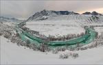
Altai. Teletskoye lake. Season in Altai When is the best time to go to Altai
The main tourist season in Gorny Altai falls on June-August. The sharply continental climate leaves little room for choice. However, good weather during the day starts from mid-May and lasts until the end of September. True, the nights during this period are cold (up to negative temperatures).
Weather in Altai
In summer
In general, the weather in Altai is very changeable. During the day, in the summer, it reaches +30 degrees, at night + 10-12. It may suddenly rain, and just as suddenly it will end. In the highlands, the weather is even more capricious: in the upper reaches of the Chuya, in May, during the day we were exhausted from the heat, and in the morning the tents were covered with snow. The water in mountain rivers and lakes is always cold, so swimming is more like winter swimming. Although, you can get used to it. After a couple of weeks, we already managed to make small swims. Water warms up only in Lake Aya and in the Katun baths. You can also swim in the artificial lakes on the Turquoise Katun, and in the outdoor pools on the territory of the camp sites.
in winter
There are several ski bases for winter recreation: in Gorno-Altaisk itself, in the village of Manzherok, and also near the village of Aya on Mount Vesyolaya. It is better to book accommodation in advance, and not because there are so many people, but in order to prepare the base. New Year's holidays do not count - at this time there is always a full house. In winter, the temperature is always in the red, however, it is felt differently everywhere. For example, in the foothills the frost is much milder than in the Chui steppe. This is also due to the amount of snow: the more it is, the easier it is to endure frost.

Spring and autumn
The most “dead” months for tourism are the off-season, i.e. October - November and March - April. Then there is still / already little snow, and it is still cool for the main summer entertainment. However, during this period, year-round hotels, sanatoriums and recreation centers continue to operate (but then it is better to go with a large company, because there are very few people). In late September - early October, you can admire the turquoise color of the Katun, and from the end of April, rosemary (maralnik) begins to bloom.

Festivals of Gorny Altai
"Green Paradise"
At the end of August, a festival of bard songs is held annually in the area of Lake Teletskoye. It is called differently, depending on the location. "Green Paradise" in the village of Turochak or "Golden Songs of the Golden Lake" in the village of Artybash. This festival cannot be found by sound, we even doubted whether we had arrived there, because. no music was heard from the road. Organizers fundamentally do not use equipment that amplifies the sound. And it helps to plunge into the atmosphere of the nature of the Altai Mountains. You can stay in a tent right on the festival site or rent a house from local residents. Our company prefers the first option in order to constantly be in the thick of things.

"El Oiyn"
It is celebrated every two years. Now the regular venue is the Kabailu-Mezhelik valley, located near the village of Elo, Ongudaysky district. This is a real extravaganza of national culture! For this alone, it is worth going to Altai. Here they compete in everything: wrestling, racing, lifting stones, playing with a whip, throwing a mace, dressing an untrained horse, etc. In between competitions, national songs are sung, epic storytellers (tai chi) and masters of throat singing perform. Exhibitions are held: a competition of yurts, the "City of Masters", national musical instruments. Lots of competitions for children and adults. For these few days, the valley turns into an anthill, which operates around the clock. We forgot about sleep and food, because it is almost impossible to have time to see everything. The organizers offer accommodation either in a tent camp or at nearby camp sites.

Tourist base "Manzherok"
Every summer month, or even twice, various festivals are held here. Starting from bard (end of May - beginning of June) and ending with bikers (end of August). In July - August there are often rock music festivals. The program is always rich, the stage is big, the sound is professional. The administration of the base has long "eaten the dog" on holding such large-scale events, so the organization is always at the highest level. Accommodation is possible both on the territory of the base (summer houses or cottages), and outside the territory, in a tent camp. Although you rarely have to sleep at such concerts and not enough, so as not to miss anything. The most active party-goers from our company generally managed to sleep in the car. In addition to the musical program itself, there are always competitions for the audience. There are various fairs (from rock paraphernalia to local souvenirs) and other entertainment (shooting gallery, master classes, body art).


Festival dates are never the same. The organizers always adjust to the weather, weekends and many other factors. It is always better to check the schedule on the Internet.
But by the beginning of June, summer finally wins. In the mountains below 2000 meters, the average June temperature rises above 10 degrees Celsius. The duration of such a period in the mountain valleys of Altai varies from 90 days (Kosh-Agach, 1958 meters) to 110 days a year (Ongudai, 810 meters). The period with temperatures above 15 degrees Celsius in the steppe valleys of Altai, lying at an altitude of up to 1200 meters, lasts about a month. At high altitudes, such a period is observed only every second year.
July is the warmest but also the rainiest month. In the foothills, the average temperature at this time is 17-18 degrees, at an altitude of 1000-1200 meters it drops to 14-15 degrees, and above 2000 meters - up to 8 degrees or less. Nevertheless, on some summer days, the air can warm up to 20 degrees even in places located above 2000 meters, and at lower altitudes it can be up to 30-35 degrees of heat. On such days it is hard to believe that eternal ice and snow lie somewhere very close, and a strong wind blows snow off the overhanging cornices. But the next day, you can wake up from the rain on the roof of your tent. You crawl out and see ragged lead clouds hanging over mountain ranges, drooping and wet branches of trees and shrubs. Well, this is also possible, since during the warm period (May-August) 80-90 percent of the annual precipitation falls.
However, not all areas have the same humidity. In the Western Altai (Terektinsky and Katunsky ridges), up to 12-18 centimeters of precipitation falls per month, but in the Eastern Altai (Chuiskaya, Kuraiskaya steppes and the Ukok plateau), the amount of moisture decreases to 2-4 centimeters per month. In this regard, the vegetation also changes from taiga (Western Altai) to high-mountain steppes and semi-deserts (Uimon, Chui, Ukok).
Thunderstorms are common in June and July. In the Katun valley and on Lake Teletskoye 10-13 thunderstorm days per month.
When choosing equipment, clothing and footwear for summer hikes, tourists should take into account that Western Altai has a humid climate with frequent rains, while Eastern Altai has a more arid climate. When it rains heavily, the tent starts to leak. Therefore, we recommend stocking up on awnings made of vinyl chloride film or tarpaulin in advance. Consideration should be given to protecting clothes, shoes and backpacks that get wet quickly when moving through wet thickets and when crossing numerous rivers and streams. Each tourist should have a spacious suit made of water-repellent fabric. The backpack can be covered with oilcloth on top or sewn into an insert for groceries and spare clothes. Be sure to have spare shoes.
At the end of August and September, the amount of rain decreases sharply. Frosts, which become more frequent by the end of August, are the first sign of the approaching autumn, and their onset is somewhat ahead of the average daily temperature drop below 10 degrees Celsius. Snowfalls are already possible on the passes above 2000 meters.
In September it becomes noticeably colder in the mountains. So, in the Katun valley, the average September temperature is 4-5 degrees, above 3000 meters it becomes below zero and the first snow falls.
Most tourists prefer to travel to Gorny Altai in summer. But that's because they don't know how beautiful it is there in autumn.
Better mountains can only be mountains in autumn. And you need to admire the Katun from October to the end of December, when it becomes turquoise with snow-white foam. And now there are almost no tourists in Gorny. This means that, for example, there will be no crowds of people at the confluence of the Katun and Chuya, there will be no unfamiliar faces in the photo with Geyser Lake, and on the Ilgumen threshold (finally!) It will be deserted.
.jpg)
Chemal
In summer, the village is not overcrowded. Chemal is chosen for its relative proximity (when compared, for example, with the village of Aktash), a good road, the presence of tourist bases for any budget and attractions.
In autumn the picture is different. There are almost no tourists. Most of the roadside cafes, where in the summer there were almost queues, are closed. Even the shops are not all open.
Be sure to visit Patmos. This is an island where a wooden church of St. John the Evangelist was erected. The path to it lies along a hanging bridge. It is 30 meters above the level of the Katun. You will be walking for a very long time. More precisely, you will stand on the bridge for a long time. To take pictures and just try to remember the view.

You can even go to Chemal for the weekend. Leave early on Saturday morning, return on Sunday evening. You will not regret.
Not a soul and everything is a soul
Further more. More precisely, further is better. If you have the opportunity and time, leave, well, at least towards the Ongudaysky district. The road is difficult: serpentines, sharp turns. So do not ignore road signs and follow the speed limit. On the other hand, the Chuysky tract is in almost perfect condition. It makes no sense to talk about the beauty of the tract. It is included in the top 10 most beautiful roads in the world. In this rating of the National Geographic magazine Russia, the Chuisky tract is in fifth place.
To get to the village of Kupchegen, you will have to overcome two passes: Seminsky and Chike-Taman. When you get up, turn off the music in the car so as not to anger the spirits. When you go up or go down the serpentine, where there is a rock on one side and a cliff on the other, you start to think that these are not such superstitions.

Kupchegen is located at 672.8 km of the Chuysky tract on the banks of the Bolshaya Ilgumen River. A few more kilometers and you will find yourself at the confluence of the Bolshaya Ilgumen and Katun rivers. Here is the famous Ilgumen threshold. A place of attraction for water sportsmen. And not only.
A seething river, huge stones, two-meter waves, the roar of water and all kinds of turquoise shades against the background of pearl-white rocks - such a picture attracts, and then does not let go. It is impossible here in autumn, it is simply incredibly beautiful.

geyser lake
It is no more than 30 meters in diameter. In the center, thermal springs are beating, which bring blue silt to the bottom, as a result of which the lake looks extremely impressive. Similar lakes are located in large numbers in Yellowstone National Park in the United States.
Getting to the Geyser Lake is easy: it is located 8 km from the Aktash village towards Kosh-Agach. It's hard to get past. There will be a sign on the road. You can go to the lake through the base. It's not free: 50 rubles per person. But the road will be comfortable and fast.

The pros of visiting the lake in autumn is that there will most likely not be people there. In summer, there are crowds of tourists around the reservoir. And in contrast with nature, the color of the water will be completely different than in summer.
Katu-Yaryk
You can't just take and move Kata-Yaryk. Insanely beautiful pass and just as difficult. It is impossible to travel by car. Either transfer (from 5 thousand rubles), or hire a tractor (from 3 thousand rubles).
Many people say that the real Mountain begins just behind the Katu-Yaryk pass. Chulyshman valley, Red gates, stone mushrooms, mountain lakes and untouched nature. Not so many people come there in the summer, in the fall they are not here at all.

This is, of course, only an approximate route. You can go to the Multinsky lakes or Teletskoye, visit the famous red mountains "Mars" and "Mars-2", the Aktash relay, the Karagemsky breakthrough, the Kucherla settlement. Yes, a lot. But be sure to do it in the fall.

And here's another
If you want to go to a specific base, then call and check if it works. Even if on the Internet the site is marked "year-round". Some bases that supposedly work in the fall are actually closed.
On the other hand, if it doesn’t matter to you where to live in Gorny, you don’t have to call or book anywhere. In autumn there are places almost everywhere. You can easily find a place to stay for the night.
The weather in the mountains is unpredictable. Those who went at the end of September 2018 said that it would be nice to take more summer things. But warm clothes are definitely worth taking more. Including winter boots and a winter down jacket. As soon as the sun sets, it becomes very cold.
We must immediately remember that territorially there is the Altai Territory, and there is the Republic of Altai. My goal now is to describe interesting places in Altai in general, so some of them will refer to the Republic, the other to the Altai Territory. What to visit in Altai is up to you. Altai is huge and different. The article contains only a part of the places that you can visit in Altai. This is not all, you can come to Altai every year and all your life, but every time you find something new.
The main factors that attract to Altai are, of course, nature views, climatic features and mineral springs. There is an abundance of sun in the Altai Mountains, amazingly clean and transparent air, a high degree of air ionization. The nature of the region captivates with its grandeur and originality. There are many salt and fresh lakes, relict forests grow, bizarre rocks, unusual caves and grottoes rise. The Altai Mountains, according to many people, bring pleasure simply from their contemplation.
What else is important to know about traveling in Altai:
- There are developed tourist places - Chemal and Teletskoye. There are a lot of tourists, and the facilities are not bad. You can get there by public transport, by car or even by hitchhiking.
- But the most interesting places in Altai are located where buses do not go and rides are very rare. Almost wild places where you can drive off-road vehicles, on horseback, and somewhere - only on foot. Rest without comfort and not for everyone. Romance and extreme!
- Who by car, off-road in Altai is provided to you magnificent. Unless of course you decide to deviate from the track. But this way you can see many beautiful places.
Places worth visiting in Altai:
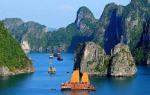
Lake Teletskoe (n. Artybash)
Teletskoye is the largest lake in Altai and one of the largest in Russia. The depth of the lake reaches 330 meters (25th position among the deepest lakes in the world). More than seventy rivers and streams flow into Teletskoye, and only one river, the Biya, flows out. The lake is located in a depression between the Korbu and Altyn-Tu mountain ranges and the spurs of the Abakan Range. The shores of the lake are mostly steep, represented by mountain slopes, which are completely overgrown with forest. There are real “century-old” cedars here.
The main popular attractions in the area of Lake Teletskoye:
- waterfalls on the Third River.
Swimming on Teletskoye is not comfortable. The lake is filled with water from mountain rivers and has a great depth. The water in it remains cold even in summer, warming up no higher than 10°C. But thousands of tourists from year to year come here to look at the unique beauty, filled with mystery and mystery ... In the region of Lake Teletskoye, the paths of many complex routes pass (this is if you order a tour of Altai).
The most famous settlement on Teletskoye is the village of Artybash. The road ends here and in the summer months the village becomes a local tourist center.  It is here that the camp sites are located, excursions are made from here, and, of course, the most interesting active routes begin from here.
The lake can be accessed from two sides.
For those who are interested in a more difficult and farther way - the southern shore of Lake Teletskoye. To get there, you need to pass through the Katu-Yaryk pass and the valley of the Chulyshman river. The road is quite tiring, but the views here are beautiful. Read more at the end. You can stay in cabins or tents.
An easier way is to drive up to Lake Teletskoye from the north side through the village of Artybash.
Turquoise Katun is a tourist complex located on the left bank of the Katun River, in the area of Mount Red Stone. That is, this is not the whole Katun, but only part of the coastal zone. Here you will even see alpine meadows, forests with different tree species and a mountainous landscape. The total area is 32.3 sq. km. The complex is actively developing. 
In the central part are the main objects:
- an artificial lake with an area of 7 hectares, warmed up to 23 degrees. For comparison, the temperature in Katun on the hottest days barely exceeds 10 degrees.
- around the artificial reservoir there are 5 cafes,
- water park, children's pond with attractions.
There are eight recreation centers on the territory of the complex. A wide variety of excursions, rafting, horse and bicycle rides are offered.
If you are looking for a holiday with comfort, this is Turquoise Katun.
Regular buses run to Turquoise Katun from Novosibirsk, Barnaul, Biysk and Gorno-Altaisk. If you get on your own, then from Biysk you need to drive here along the Chuisky tract, bypassing Srostki, Mayma and Manzherok.
The system of Tavdinsky or, as they are also called, Taldinsky caves is easily accessible. They are located in the popular tourist area "Turquoise Katun" near the village of Izvestkovy.  There are about 30 caves on the rocky five-kilometer ledge. The caves are interconnected and have several entrances. The most popular of them is "Girl's Tears" or "Tavdinskaya". The caves have been used by people since the Bronze Age, as evidenced by the archaeological finds made under their vaults. And from the top of the Tavdinsky mountain, a beautiful view of the beautiful Katun and the Chuisky tract opens up.
A road and signs lead from the bridge over the Katun to the caves. The entrances to them are visible from afar.
House-Museum of V. M. Shukshin
Located on the territory of the Altai Territory, Biysk region, in the village of Srostki. Guided tours have been open here since 1978. Consists of three houses. Vasily Shukshin's mother lived in one house, his childhood once passed in the other, and also the school building. The estate covers an area of 1.16 hectares. They will also tell about the memorable corners of the village, one way or another connected with the life of V.M. Shukshin. 
The local sea is Big Spring Lake. There are no mountains nearby. It is located on the territory of the central Kulunda steppe, 8 kilometers west of the city of Slavgorod and 400 km from the city of Novosibirsk. The Scythian peoples who lived here earlier endowed the reservoir with the magical properties of making wishes come true! 
At the bottom of the Yarovoye, two lines intersecting with each other were found. Scientists consider these furrows to be anomalous (in the good sense of the phrase). The water is both bitter and salty.
Lake Bolshoye Yarovoe Lake is located on a plateau, on which there are practically no trees. The shores of Yarovoye are quite high, and the south and southwest of the coastal territory is cut by ravines.
The lake is closed, nothing flows into it and nothing flows out. The composition of the water is unique, enriched with minerals, and everything else - artemia lives in the lake, dying, it mixes with salts and silt, forming an impressive mud layer endowed with healing properties. The taste of water, in addition to salinity, has bitterness, the lake belongs to a brine-type pool, the supply of which is provided by underground springs.
The mud of the Great Yarovoye Lake is comparable in its performance to the mud of the lakes of such resorts as Odessa, Saki, Staraya Russa. Not very far from Yarovoye is another, but small, which has nothing to do with Altai, but is also known for its therapeutic mud. Unlike Yarovoye in Karachi, rest is wild, although there is also a sanatorium founded under the king (but the prices are still the same).
And many go to Yarovoye, photos from there are not always easy to distinguish from Anapa, for example. Also sand, sun, a lot of people on the beach. There are many sunny days, dry climate. Bolshoye Yarovoye Lake is perfect for health tourism. The territory is equipped, there are guest houses and high-rise buildings where apartments are rented. Yarovoye was granted the status of a natural monument in 1978.
Nizhnyaya Katun area
The Nizhnyaya Katun region is located in the central part of the Altai Republic, in the Chemal region. The area with mountains of low height, overgrown with forests with a transition to the mountain-steppe zone of the Northern Altai. The territory of the district includes the valley of the lower Katun and the system of small mountain rivers. The area begins in the village of Ust-Sema, if you turn onto the Chemal highway from the Chuisky tract, which goes across the bridge to the left bank of the Katun. 
Chemal region in terms of tourism is one of the most developed. It is accessible in terms of transport, has favorable climatic conditions, a unique and very picturesque landscape, and cultural and historical objects are also located here. Tourist bases and recreation centers have been built on the territory of the district.
As in the whole Altai, various excursions are offered along thematic routes by car, on foot or on horseback. The current of the Katun in this area is not very rough, which allows you to make an rafting with instructors for tourists with a low degree of preparation.
Archaeological objects are concentrated to the south of Chemal along the Katun, on the section of the road from Elanda to Kuyus. These are the sites of ancient people of different eras, burial mounds, burial grounds, rock paintings. Here is the famous Chemal hydroelectric power station, the temple of St. John the Theologian on the island of Patmos. The valley of the Lower Katun can be called an ideal place for those who like to combine outdoor recreation, excursions with comfort.
The highest point of the Altai Mountains is located on the Katun Ridge. There are various names in local dialects: Uch-Sumer, Kadyn-Bazhy, Muztau shyny. 
In the location of Belukha, earthquakes are common. The seismic activity of the zone is high, 7-8 points.
Summer is cool here. The average temperature at the foot of Belukha in summer is +6 C. Then comes an incredibly harsh winter (up to -48 C). Snow can fall in the summer, rain is a common thing.
At the foot of Belukha, dense coniferous forests and berry bushes, birches and alpine grasses, tundra lichens and Red Book flowers peacefully coexist.
The animal world in the vicinity of Belukha is ruled by small rodents - mice, voles. It happens that the stony slopes of the mountain will be honored by the presence of a lynx and a Siberian goat, or even a rare predator, the snow leopard.
Birds have chosen Belukha. Partridges, sparrows and even golden eagles settle here.
Mount Belukha is shrouded in myths and legends of varying degrees of gloom. The most famous one says that at the foot of the mountain there are gates to Shambhala (or Belovodie). Modern admirers of the ideas of the notorious Roerichs consider Belukha a place of power and the only safe place on Earth in case of another doomsday.
The Sofia Glacier can be reached from the village of Beltir in autumn. In winter there is a lot of snow, and at the beginning of summer there is too much water in the gorge.

Martian landscapes beyond the village of Beltir
And if you go to the very one to the Sofia glacier or Karagemsky and other gorges, you will see such landscapes. Places in Altai are not popular among tourists. So to speak, for the sophisticated. But if you compare it with a photo from Mars, it looks very similar (not counting the sky). 
Lake Aya
Aya is a very popular lake in Altai and also a warm lake. The size of the lake is small - 409 x 190 m, the average depth is 12 m, the maximum depth is 24 m, the water temperature in July is + 22 + 24 0С.
On the shore of the lake there is an equipped beach (water slide, sun lounger rental, showers, toilets), a boat dock. Summer cafes and shops in the vicinity are also present. A number of routes from other places of rest in Altai are offered to Lake Aya. For example, scheduled excursions are conducted from the lower Katun region, including a visit. 
Lake Aya has healthy air, a lot of sun. The shores of the lake are surrounded by low cliffs, covered with mixed forest. Not only residents of nearby territories come here, but from all over Russia and from beyond its borders. Lake Aya is located just 450 meters from the left bank of the Katun at an altitude of 380 meters above sea level.
Mount Devil's Finger
The rock is one of the most popular sights of the Altai region, located near Lake Aya.  The Devil's Finger Rock is one of the most popular sights of the Altai region, located near Lake Aya.
Valley of the Chulyshman River and the Katu-Yaryk Pass
The descent into the valley goes along a serpentine. The road is considered unsafe. Different cars are passing by, even right-handed sedans. Although it is difficult for the latter to climb later, it is easier to slide down. 
Mountain trails in the area of the Aktru gorge, the trail to the Blue Lake and the Aktru glacier
There are many places in the Aktru Gorge where you can go on foot. There are very difficult routes here, where you can go only with equipment and in bundles, and there are simple ones, for a day or even faster. There is a one with the same name. Climbers come there, you can check with them about the routes.
It is not always possible and not for everyone to get to the Aktru base by car. You need to know the road, and not just any car is needed ... 
A legendary place shrouded in secrets and legends. The Ukok Plateau is located at the junction of the borders of Kazakhstan, China, Mongolia and Russia. The height is 2200-2500 m. It is windy here, in winter the temperature drops to -50. The highest point of Ukok is Mount Kuiten-Uul 4374 (the second highest in Altai). 
It was here that an ancient burial was found, from which the mummy of a woman, called the Princess of Ukok, was recovered. Local residents are still fighting with the authorities for the return of the princess to the burial place, they consider the fact that they took her from the plateau to be bad. The place is strange, cold, wonderful. But it draws you back again and again ... It is more likely to travel here in August-September. In spring and early summer there is a lot of water, sometimes snow. You can drive to Ukok either through the Warm Key Pass (the most likely way) or through the Jazator River. On the Ukok plateau there are organized tours in groups.
It is located in the south-west of the Altai Territory and border areas with Kazakhstan: Zmeinogorsk, Krasnoshchekovsky and Tretyakov regions.
Formed in 1999. At the moment it occupies an area of over 40 thousand hectares, there are plans for further expansion. The proximity of the reserve to the black taiga, where there are no traces of human activity yet, creates a reason to consider these territories for new areas of the reserve.
There are several natural monuments on the territory of the reserve:
- scary cave,
- foot-and-mouth cave,
- cave Hyena Lair,
- Silurus cut,
- log Scary,
- Mount Seven Cave
- Tigirek fortress.
More than 600 species of plants, many mammals (65 species) and birds (117 species) grow within Tigireksky. Brown bear, roe deer, elk and deer live here, as well as Siberian weasel, sable, ermine, squirrel, white hare and chipmunk. You can see (although less often) wolverine, weasel, lynx, musk deer. There are a lot of feathered creatures in the reserve: for example, black grouse, hazel grouse, long-tailed owl, upland owl, nutcracker, capercaillie.
The relief is represented by small hills stretching throughout the reserve, topped with domed peaks, the shape of which gave the name to the reserve (“tigirek” is translated into Russian as “round, smooth”).  In winter, the places are dangerous, especially in the southeastern part, where avalanches, landslides and talus are frequent. In the east there are canyons and gorges, and the northwest is represented by a gentle slope.
The historical monument - the ruins of the Tigirek fortress - dates back to the 18th century. At one time, the fortress had the role of an outpost of the Kolyvano-Kuznetsk fortification line. The remains of the fortress are part of the era of Russian settlements on the territory of Altai, over the mines and factories of which the threat of Dzhungar raids hung. Today, a piece of history is a memorial building of military engineering art.
Several tourist routes have been laid along the protected area, which can be overcome on horseback or on foot. These roads are associated with the inspection of colorful landscapes, woven black taiga, steppe meadows, mixed forests, woven birch, pine and fir trees. Observation platforms of natural origin provide beautiful panoramas of the river valleys of the Big Tigirek and Ini. The trail linking the villages of Chineta and Tigirek can present a meeting with large birds of prey and ungulates represented by elk and roe deer.
Within the Altai Territory, the Tigirek Reserve is the only specially protected area on a federal scale.
Edelweiss Valley
The Edelweiss Valley (Yarlu Valley) is one of the most beautiful and amazing places in the Altai Mountains. It is located near Belukha Mountain, to the left of Akkem Lake, at an altitude of about 2000 m above sea level. The name of the valley is really speaking: flowers that are very rare in nature, listed in the Red Book - EDELWEISS, grow here. 
Small, fluffy, very delicate in appearance! There is also a stone fortress in the valley. This place is certainly sacred for people, as evidenced by numerous stone figures built inside the fortress.
Petroglyphs Kalbak-tash
A large array of ancient rock paintings aged over 5 thousand images. According to scientists who studied Kalbak-Tash, the drawings were created by people who lived here from the Neolithic period (IV-VI centuries BC) to the Middle Ages (VIII-X centuries AD). On the stones you can see the figures of animals that inhabited the Altai several thousand years ago, hunting scenes and various, including solar, symbols (which once again indicates that swastika y was not invented by Hitler, and its meaning is completely different than many people think). The petroglyphs were made with both stone and metal tools. Researchers attribute well-preserved runic inscriptions to the ancient Turkic era. Some of the plots depicted can be easily correlated with the famous Altai myths. 
You can get to the rock complex from the Chui tract. It is located on the right bank of the river. After the mark "723 km" you need to turn left between the fourth and fifth pillars of the power line and walk about 20 meters.
stone mushrooms
Unusual rock forms, created by nature as a result of a long weathering process, are located in the valley of the Karasuk River - one of the tributaries of the mighty Chulyshman. Fanciful stone mushrooms consist of rocks of heterogeneous composition and picturesquely rise above the slopes of the valley. Unfortunately, over time, unusual natural formations continue to collapse. According to local residents, some of the "hats" collapsed during a strong earthquake that occurred in the Altai Mountains in 2003. 
You need to go to the mushrooms along a dirt road laid along the Chulyshman valley. From the mouth of the river (i.e. from Lake Teletskoye) the journey takes about 2 hours. The road near the Ak-Kurum tract runs along the opposite (left) bank of the river, to get to the "mushrooms", you need to cross the river and climb up the path.
Lower Shavlinskoye Lake
The lake lies in the spurs of the Severo-Chuysky ridge at an altitude of almost 2000 m above sea level and is framed by picturesque high peaks, from the glaciers of which the Right Shavla River flows. This is one of the most popular tourist sites. Hiking and horse trails. The eastern shore of the lake is overgrown with a good larch and cedar forest, in which there are thickets of lingonberries and blueberries, and in non-dry summers there are many mushrooms. Chipmunks live here. 
The water of the lake is clean, grayling is found here. It is customary for tourists standing on the banks of Nizhny Shavlinsky to use water from mountain streams flowing into the lake for drinking and cooking needs. In the middle of the populated eastern shore is the Glade of Idols, where wooden sculptures are exhibited, made by the hands of people who visited these places. And the opposite western shore of the lake is steep and rocky, and there are no places for bivouacs on it.
There is a walking route about 35 km long from the village of Chibit to the lake. It is laid along the path through the Oroi pass (about 2200 m) to the Eshtykol plateau. And the final part of the path passes along the path on the right side of the Shavla River valley.
Belokurikha
The city of Belokurikha is a beautiful resort with a developed structure of entertainment centers (about twenty restaurants, bars and cafes, a bowling club, an aqua park that welcomes guests all year round) and sanatoriums. In spring, summer and autumn, Belokurikha attracts tourists with the beauty of its nature, and in winter it invites them to the ski slopes located in the resort area of Belokurikha.
Located 230 km from Barnaul and 70 km from Biysk. 
The main wealth of these places is radon sources. The waters of the springs rise from a depth of 100-400 m through the faults of the earth's crust to the surface and absorb the information of the Earth into their "memory", which also has a beneficial effect on the human body. Treatment in the sanatoriums of Belokurikha is carried out using new methods and modern equipment, it is not cheap, but there are always vacationers at the resort.