A city on the shore of Tsemes Bay. On the shores of Tsemes Bay. Tsemes Bay: sightseeing tour

Tsemes Bay is a water area that is now occupied by one of the largest sea trading ports of the Black Sea and Russia in general. The bay washes the shores of the hero city of Novorossiysk.
If you find yourself in this wonderful town, just come to the embankment and enjoy the grandeur of the port. Also every half hour in the summer, pleasure boats depart from the central embankment. An hour-long trip around the bay is very affordable - 200 rubles. per person, so I advise
Novorossiysk is a port of world significance, which is why you can meet ships from all over the world here. For example, straight from Panama, it is unloaded near the administrative building of the organization 

These are the pleasure boats 
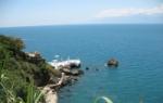
And this is the edge of a bunna (breakwater) with a lighthouse at the end. They are built in order to protect ships from storms, which are so frequent in these places in the autumn-winter period 
Three red and white pipes near the mountain are another cement plant, of which there are more than enough in the Novorossiysk region 


As you have probably already noticed, the mountains around these factories have a rather modified topography. There's no escape - the main raw material comes from them 
In the lower right corner between the mountains there is the resort village of Kabardinka, administratively belonging to the Novorossiysk region 

The oil loading part is also present here and is located at the edge of the port 
This is what a floating crane looks like 

Warships sail here constantly 
Not far from the Sudzhuk Spit there is a panoramic view of the city itself. And this memorial dedicated to the Great Patriotic War is called “Malaya Zemlya”. There is a museum inside, quite a popular place among tourists from neighboring cities. 
Tsemes Bay is a natural harbor located in the northeast of the Black Sea coast. In the northwestern part of the bay there is the hero city of Novorossiysk and the sea port. This is the second most important bay in the Russian Federation after Sevastopol. Piers, piers, breakwaters, factories, cargo, commercial and military ships - all this makes the bay unattractive from a resort point of view. However, the bay is extremely interesting for its history and natural features.
Tsemes Bay is formed by the Sudzhuk Spit and Cape Doob. In the west of the bay is the Abrau Peninsula, in the east - the Markhot Range. The length of the coastline is 15 km, the bay extends into the land for 7 km.
 The entrance to Tsemes Bay is wide - 9 km, the width in the middle part is 4.6 km
 The maximum depth of the bay is 27 meters. However, the passage of ships is complicated by the reefs bordering the shores, the Penai banks (shoals at the entrance with a depth of 5-6 meters), as well as the remains of sunken ships.
 When passing through Tsemes Bay, ships must be guided by a navigational guide, taking into account all navigational hazards
 The water temperature in winter does not drop below +5, making the bay navigable throughout the year. But from November to March the bay is subject to Nord-Ostam (Boram), when the wind speed can reach 40 m/s, and the sea state can reach 12 points. Bora (boreh) is a cold north wind. Such winds usually form in regions where warm seas are adjacent to low mountain ranges. In Novorossiysk this is the Markhotsky ridge or the Varada ridge. Residents of Novorossiysk can predict the imminent appearance of bora by the thick clouds on the mountain tops, which are called “beards”. Boron contributes to a sharp drop in temperature, the formation of an ice crust and sometimes the appearance of tornadoes. During the bora, ships go out to the open sea or sit at anchor in the calm waters of the neighboring village of Yuzhnaya Ozereevka, 12 km from Novorossiysk. Such forests are observed on the shores of the Adriatic Sea of the Balkan Peninsula, on Novaya Zemlya, on the shores of Lake Baikal.
 View of Tsemes Bay and Mount Koldun along the M-4 highway from Gelendzhik towards Novorossiysk
 Descriptions of the bora in Novorossiysk in K. Paustovsky’s story “The Black Sea”:
“Our sailors first learned what the Black Sea bora was in 1848. This was ten years after the foundation of the Novorossiysk fortification on the shore of Tsemes Bay, at the foot of the dark and treeless mountains.”
“How does bora begin? White patches of clouds appear over the bare ridge of Varad. They look like torn cotton wool. The clouds roll over the ridge and fall towards the sea, but never reach it. Halfway up the mountain slope they disappear into thin air.”
“The first gusts of wind hit the decks of ships. Tornadoes rise into the sea. The wind quickly gains full strength, and after two or three hours a fierce hurricane is already lashing from the mountains to the bay and the city. It raises water in the bay and carries it in showers onto houses. The sea is bubbling, as if trying to explode. The wind throws heavy stones, throws freight trains down slopes, rolls iron roofs into thin tubes, shakes the walls of houses.”
Why Tsemesskaya?
It is named after the river Tsemes (Tsemez) of the same name, which flows into the bay. The source of the river is located on the northeastern slope of Gudzeva (425.6 m). From Adyghe “cemez” means “forest of insects”, “rotten forest”. In the Natukhai dialect it is also translated as “forest with a lot of insects.”
The river flows through the industrial part of the city of Novorossiysk and flows into the bay in the Tsemes Grove area. The river was navigable until 1921, when the forest along the mountain slopes was cut down.
 Admiral Serebryakov embankment along the western shore of Tsemes Bay. Named in honor of the first governor-general of the city - Admiral Lazar Markovich Serebryakov (1792-1862)
 Sugar loaf and cement factories
If you are in Novorossiysk, you may hear about Sugarloaf. This is the highest point of the Markotkh ridge (558 m), so named because of its cone-shaped shape. By the way, the characteristic peak in Rio de Janeiro is also called Sugarloaf.
 View of the Markotkhsky ridge, quarries and cement plant from the Novorossiysk embankment
 Height Markotkh ridge ranges from 400 to 800 meters above sea level, it is composed of sedimentary rocks of the Cretaceous period. The name of the ridge comes from the Adyghe “markotkh”, which translates as “blackberry places”. There really are a lot of berries here, however, the main “wealth” is not blackberries, but marl, which is used for the production of high-strength cement. Therefore, the slopes of the ridge are disfigured by marl quarries, and Sugarloaf “melts” every year. At the foot there are cement factories, which does not add to the ecology of Novorossiysk.

Wrecks
Tsemes Bay has become notorious due to events related to the loss of ships and a number of anomalous phenomena. Many people call the bay the “Bermuda Triangle of the Black Sea”, where ships, divers and divers are drawn. According to one version, the bay is a crater of a cooled volcano, and therefore magnetic anomalies occur during tectonic activity and earthquakes. These phenomena are also associated with the presence of iron ores at the bottom of Tsemes Bay. According to another version, there is nothing anomalous in the bay, and all incidents are associated only with high shipping traffic. Divers still find wrecks of ancient ships in the bay.
When mentioning Tsemes Bay, they first of all remember the event of June 1918, when a squadron of ships of the Black Sea Fleet was scuttled in order to avoid its capture by the Germans. On the 12th kilometer of the Sukhumi highway above Tsemes Bay in 1980, in memory of this tragic event, an ensemble was erected "In memory of the sunken ships of the Black Sea Fleet". A 12-meter granite kneeling sailor with the inscription: “To the sailors of the revolution” is facing the Tsemes Bay. Opposite, on the observation deck there is a granite "Cube-sight", symbolizing a sinking ship.
 Inside the cube made of colored glass and metal is a flag signal that was raised on all sunken ships: “I’m dying, but I’m not giving up.”
 There is an inscription on the cube: “On June 18, 1918, in Tsemes Bay, in the name of the Revolution, courageous Black Sea sailors sank warships so that they would not fall to the Kaiser’s Germany.” On the other side: “In view of the hopelessness of the situation, proven by the highest military authorities, the fleet should be destroyed immediately. Prev. SNK V. Ulyanov (Lenin).” There is a composition along the edge "Silhouettes of sunken ships" with a picture (where known) and the name of each ship, the direction and distance to the place of its sinking. In the 1920s, some of the sunken ships were raised and restored.
 View of Cape Doob and the resort village of Kabardinka from the monument to sunken ships
 Somewhere there, under the surface of the water, lie the remains of ships
Novorossiysk
Location of the city. Climatic features. Brief history of the city.
The city of Novorossiysk is located like an amphitheater on the shore of Tsemes Bay, one of the most convenient and extensive on the Black Sea. Novorossiysk occupies 834.9 square kilometers of area. Novorossiysk is inhabited by about 220,000 inhabitants.
Novorossiysk is an industrial city and the largest port on the Russian Black Sea coast. Administratively, the villages of Abrau-Dyurso, Gaiduk, Verkhnebakansky, Gorny, Myskhako, Tsemdolina, Borisovka, as well as the villages of Natukhaevskaya and Raevskaya, united in the Primorsky District, are subordinate to Novorossiysk. In Myskhako there is a winery that produces wonderful wines: Chardonnay, Cabernet, Aligote and others. Young wines are quite inexpensive and quite accessible, while aged vintage wines increase in price greatly, but they find their buyer.
Novorossiysk itself is not a resort, because filled with industrial enterprises and has a huge port complex. There is a huge oil terminal in Novorossiysk. The port of Novorossiysk provides loading of grain and other cargo.In Novorossiysk, many kilometers of KamAZ trucks loaded with grain, waiting to be unloaded at the port, have already become a common occurrence. Due to the uncertain situation of Sevastopol, a naval base is being built in Novorossiysk. Some ships of the Black Sea Fleet are already based in Novorossiysk. Driving along Tsemes Bay towards Gelendzhik and looking down you can see warships at the piers. But the construction of the naval base is still far from complete. The industry of Novorossiysk is mainly represented by cement factories. Cement production is one of the few that remained afloat after the start of reforms in the 90s.
Resort areas with convenient beaches and many recreation centers are located near Novorossiysk - in the area of Shirokaya Balka, Sukhaya Shchel, the villages of Durso and Yuzhnaya Ozereevka. From the northeast, the city is bordered by the Markotkhsky ridge (translated from the Adyghe dialects “markotkh” means “blackberry mountains”). The mountain peaks rise to a height of up to 700 meters, but this is not enough to protect the city from the cold northern winds. The average annual air temperature in Novorossiysk is +12.5 degrees. In summer, temperatures often rise to 40 degrees. The sea breeze barely softens the heat. In winter, a powerful north-east wind (north-east), which is often called the “Novorossiysk forest”, breaks down from the nearby mountains and powerfully hits the city and Tsemes Bay. At this time, ships are forced to leave the port and wait out bad weather on the open sea. The nature in the vicinity of Novorossiysk is quite diverse.On the slopes of the mountains grow juniper, butcher's broom, blackthorn, ivy, pistachio, sessile oak, dogwood, mackerel, and euonymus. In the mountain forests there are wild boar, roe deer, marten, badger, jackal, hedgehog, Mediterranean tortoise, and steppe eagle. Cormorants, coots, grebes, teals, terns live near the sea, and mute swans spend the winter. In Novorossiysk, on Sovetov Street, 58, there is a historical museum, where various exhibitions on the history and nature of the Novorossiysk region are presented. (t.23-00-00)
Back in the 6th century BC. On the shore of Tsemes Bay, the Greeks founded the ancient colony of Bati. In the XIV-XV centuries, the Genoese built a fortress at the mouth of the Tsemes River. Under the Genoese, the bay bore the name Kalo Limeno ("Beautiful Harbor"). In 1722, the Turkish fortress Sujuk-Kale arose on the southern shore of the bay. After the end of the next Russian-Turkish War in 1829, under the Treaty of Adrianople, Turkey ceded its rights to the eastern coast of the Black Sea from the borders of Abkhazia. On September 12, 1838, Russian troops landed in Sudzhuk (Tsemes) Bay and the construction of a fortification began, which later received the name Novorossiysk. The naval part of the operation was led by the commander of the Black Sea Fleet, Vice Admiral M.P. Lazarev. The landing force of more than five thousand people was led by the head of the first section of the Black Sea coastline, Lieutenant General N.N. Raevsky. His staff included the headquarters officer for the movement and operation of naval detachments on the eastern shore of the Black Sea, Rear Admiral L.M. Serebryakov, the future builder of Novorossiysk.
In his report to Nicholas I dated September 15, 1838, the commander of the Black Sea squadron, Admiral M.P. Lazarev, noted the “convenience of the location” of the bay. He recognized the very structure of the pier for ships as “more convenient than in Gelendzhik.” On January 14, 1839, the fortification in Sudzhuk Bay was given the name Novorossiysk, and on December 15, 1846, the fortification was transformed into a city. Its main advantage, which predetermined its further development, was the convenient, largest in the Caucasus, ice-free Tsemes Bay. But, time passed and the strengthening of Russia on the Black Sea shores excited the mistress of the seas, England and her allies. As a result, English and French troops landed near Sevastopol and this war was called the Crimean War. In 1855, during this war, Novorossiysk was fired upon by an Anglo-French squadron for four days and returned fire. Only the return fire of the artillery batteries of Novorossiysk did not allow the enemy to land troops. The Anglo-French squadron went to sea having suffered losses and damaged ships. However, as a result of the war, Russian troops were forced to abandon the fortifications on the Black Sea. By order of the command, the garrison leaves the city, and the residents are resettled in the Kuban villages. In 1858, a decision was made to restore the fortifications and the garrison returned to Novorossiysk. In March 1866, Novorossiysk became the center of the Black Sea District. The first major building in the city was a cement plant, which was built in 1882. In 1888, the railway came to Novrossiysk and, as a result, the construction of a port and elevator began. With the construction of the port, the export of grain abroad from the Don, Volga region, Kuban and Stavropol region increases. In 1887, construction of the Novorossiysk-Sukhumi highway began. In Russia at that time there was a crop failure, famine and workers willingly went to construction. But the food supply during construction was not much better and this road was often called the “hungry highway.” Despite all the difficulties, the road is more than 500 km in five years. was built, which had a great economic effect. In 1896, the Black Sea District was transformed into the Black Sea Governorate with its center in Novorossiysk. At the end of the 19th century, attempts were made to organize a resort in Novorossiysk. Dmitry Serafimov’s bathhouse appears in Novorossiysk. The bathhouse was a wooden structure with a roof and small windows. The bathhouse was located on stilts far from the shore. The bathhouse had 80 rooms and had baths with heated sea water and healing mud. There was also healing mineral water and, in addition, a restaurant with a buffet. The example turned out to be contagious and other baths soon began to appear. In 1904, the Novorossiysk Resort partnership appeared. The resort business developed and in 1910 the Black Sea Express train was launched on the route St. Petersburg - Novorossiysk, via Moscow. The train ran year-round and included carriages of different classes and a dining car. Express cars were delivered directly to the pier, where transit passengers could travel further to Tuapse, Sochi, Gagra and other settlements.
The first Russian revolution of 1905-1907 also affected Novorossiysk. Rallies, strikes, and demonstrations took place here. From December 11 to December 25, 1905, power in the city belonged to the Council of Workers' Deputies. This period was called in history the “Novorossiysk Republic”.By 1914, the city became a major industrial and commercial center of the North Caucasus and had a population of about 63,000 people. During the Civil War and intervention in Tsemes Bay, the Black Sea Fleet was forced to scuttle. If you drive along the Novorossiysk-Sukhumi highway, then along the road, on the shore of Tsemes Bay, there is a monument to these events. On the memorial sign there is the inscription “On June 18, 1918, in Tsemes Bay, in the name of the revolution, courageous Black Sea sailors sank warships so that they would not fall to the Kaiser’s Germany.” To this day, warships of the Black Sea Fleet rest at the bottom of Tsemes Bay.


After the events of 1917 and the end of the Civil War, Novorossiysk continued its development as a port and industrial center. During the Great Patriotic War, the city found itself in the center of battles and was almost completely destroyed.
At the end of the summer of 1942, German and Romanian troops strive to break through to the Caucasus. Mountains cover the access to the Black Sea. The enemy is trying to reach the Caucasus coast through a narrow strip along the sea. Novorossiysk turns out to be a traffic jam for German troops. In the area of cement factories, the front stabilizes for a long time. Traces of the battles can still be seen when driving to the resorts of Gelendzhik. The front line was on the eastern outskirts of the city. And, the heroic landing of Major Caesar Kunikov’s detachment on the legendary and subsequent defense, which lasted 225 days, went down in history.
The development of the city continued in the post-war period. In 1964, the country's largest oil harbor, Sheskharis, was put into operation. The deep-water berth is capable of receiving tankers with a capacity of up to 250,000 tons.
A powerful impetus for the development of the city was the creation of a maritime shipping company in Novorossiysk, which included the largest tanker fleet in the country.
In September 1973, Novorossiysk was awarded the title of Hero City.
Until the 70s, Novorossiysk had very big problems with water supply. Novorossiysk does not have its own water supply sources and water was transported to Novorossiysk by tankers from Tuapse. There were queues for water. It was decided to build a water pipeline on the Black Sea coast. The current State Unitary Enterprise "Troitsky Group Water Pipeline" was organized on the basis of the decision of the Krasnodar Regional Executive Committee dated July 28, 1971 No. 497 and the order of the Kraiuprkomkhoz dated August 10, 1971 No. 161 "On the creation of the production department of the Troitsk Group Water Pipeline."
The purpose of creating TGW was the extraction of fresh groundwater for domestic and industrial water supply to the cities of Novorossiysk, Krymsk, Gelendzhik and the adjacent resort area of the Black Sea coast.
After the arrival of fresh water in Novorossiysk, a monument was built on the embankment of Tsemes Bay. In 2006, the monument was restored.
In 2004, a monument to the General Secretary of the CPSU Central Committee Leonid Berzhnev was erected in the center of Novorossiysk. Representatives of the city administration, a delegation from Ukraine and veterans of the Great Patriotic War took part in the opening of the monument. The monument, about two meters high, was made by sculptor Alexander Bugaev. The sculpture was called "Man Walking Through the City." The Soviet leader is represented with a cloak slung over his shoulder. This is the second monument to Brezhnev in the former USSR. The idea of installing the monument belongs to the mayor of Novorossiysk D. Shishov. The installation of the monument was timed to coincide with the anniversary of the liberation of the city from German-Romanian troops on September 16. As you know, the former leader of the Soviet Union fought in these places and did not forget Novorossiysk after the war.
Now, despite the existing problems, the city of Novorossiysk is developing, the reconstructed embankment has become more beautiful, modern buildings are appearing, the port's trade turnover and orders for cement industry products are growing.
I arrived in Novorossiysk on a March morning, unusually sunny and warm for a resident of the northern swamps. In St. Petersburg the snow has not yet melted, in Rostov-on-Don it is windy and chilly, but here trees and tulips are already blooming. My mood rose to the level of “superpositive”, and having come to my senses a little after a half-sleepless night on the train, I, squinting from the sun’s glare on the sea surface, went for a walk along the city embankment.
In fact, I deceived you. The first thing I did was not go for a walk along the embankment, but to Malaya Zemlya. In February 1943, in accordance with the plan of attack on Novorossiysk "Sea" occupied by the Germans, troops were landed here. The defense of the occupied bridgehead lasted 225 days. The defenders were in extremely unfavorable conditions compared to the Germans - Malaya Zemlya, open to all winds, was perfectly shot from the surrounding heights. The bridgehead played its role; one of the three groups of troops advancing from it ensured the blocking and capture of Novorossiysk. By the way, L.I. Brezhnev fought on Malaya Zemlya as a military political commissar, and it is with this circumstance that increased attention is attributed to this heroic, but generally ordinary, in the opinion of military historians, episode of the Great Patriotic War.
The monument to the defenders of Malaya Zemlya - the stylized bow of a landing ship was unveiled in 1982.
And, as it turned out, I was extremely lucky with the weather. For, according to local residents, just the day before an icy wind blew here, the famous bora. I experienced first-hand what Novorossiysk boron is in the distant past. Here is a photo in almost the same place as the previous one, but twenty-four years ago. I'm with my father on Malaya Zemlya. Bora is blowing. I still remember how it knocked me off my feet and chilled me to the very bones.
In ancient times, on the spot where the monument to the defenders of Malaya Zemlya stands, there was a small Turkish settlement with the Sujuk-Kala fortress. A small cape protruding into the sea a little to the south still bears the name Sudzhuk Spit. They write that in summer this is a favorite vacation spot for local residents. But that was in the summer, and now only rare fishermen sit on the shore.
It was this grandfather who told me when I, having reached the end of the spit, stopped, peering at the outlines of ships on the horizon, that the lighthouse lost in the haze was called Sudzhuksky, and you could wade to the island in the distance, and it was here that the episode of “The Diamond Arm” was filmed. The same one when the hero Andrei Mironov was towed to an island in the middle of the sea, and the boy who waded here at first seemed like a saint to him? "Get out of here, boy, don't bother me!" “Come on, puppy! Get out of here!”
But now I really went for a walk along the city embankment. The walk turned out to be leisurely and lazy. Sitting with my legs dangling on the edge of one pier, I had a snack of gyros (in Novorossiysk and the surrounding area I have not seen a single Arab shawarma-shawarma; the only fast food is Greek gyros). I moved to another pier a couple of hundred meters from the first, where I hung out for a good half an hour, watching future yachtsmen train on dinghies.
So I slowly made my way to the sea station. The cruiser "Mikhail Kutuzov" is moored next to the sea terminal, where a branch of the Russian Navy Museum operates.
Novorossiysk is the largest port in Russia. This can be felt by the impressive number of ships, whether standing in the roadstead in Tsemes Bay, coming from the side or towards the sea, or dimly visible on the horizon. Meeting and seeing off ships, sitting at the lighthouse at the end of the western pier of the port, you can kill the remaining couple of hours of daylight. Here is a Gazpromneft tanker leaving for the sea:
Here comes the tanker "Novosea":
Here the tugboat went to meet the guest:
And now he and his colleagues return leading the Greek “Heron”:
And all this port bustle is calmly watched by fishermen sitting on the pier at intervals of ten meters. They steal small fish from the sea. No one has a big catch in sight. They probably hide it right away...
The next day I headed to the opposite side of Tsemes Bay - to the village of Kabardinka. As a child, I vacationed here several times with my parents at the Vostok boarding house. How enormous the distances seemed then! It seemed impossible to walk from the boarding house to the bus stop to Novorossiysk. And it turns out that from there to the lighthouse on Cape Doob is at most half an hour of leisurely walking.
Here, near the lighthouse, in Soviet times there was a camp site. Now, judging by her condition, it doesn’t work. There is construction debris lying around the houses, the stairs to the sea are not repaired properly. It gives the impression that they started to repair it and abandoned it halfway through. Although in one place there were people milling about, reminiscent of builders...
It's nice to sit on the rocks at the edge of the surf, exposing your face to the sun and wind:
Cape Doob offers wonderful views:
View towards Novorossiysk. I didn’t even expect that the water in the Black Sea could be this color.
On August 31, 1986, at 11:20 p.m., abeam Cape Doob, approximately two miles from the coast, the passenger steamer Admiral Nakhimov crashed as a result of a collision with the bulk carrier Pyotr Vasev. There were 1,243 passengers and crew on board. 423 people died. My parents and I came to Kabardinka on vacation just some time after these events. I remember both the rescue ships and the disaster site fenced with buoys. A few years later, a monument to those killed on the Nakhimov already stood on the cape. Several pipes are swallowed up by granite waves and a clock indicating 11:20 p.m., recovered from a sunken steamship.
The boarding house "Vostok", where I vacationed as a child, like the tourist center "Mayak", gives the impression of being inactive. The doors in the summer houses are wide open, the glass in the sleeping buildings is broken in some places, grass sticks out of the cracks in the asphalt and bushes are already making their way in places. But at the same time, some rooms have beds with mattresses. An ideal place to stay overnight for people without a fixed place of residence.
The boarding house beach has been washed away considerably, it has become quite narrow:
But once upon a time there was enough space on it to celebrate the holiday of Neptune.
And only the view from the balconies is still the same - the Markotkhsky ridge and Tsemes Bay with cargo ships docked in the roadstead.
44°41′00″ n. w. 37°50′00″ E. d. HGIOLTsemes Bay(Also Novorossiysk Bay) - an ice-free bay in the northern part of the Russian Black Sea coast. The second most important bay in the Russian waters of the Black Sea basin after Sevastopol Bay. The bay became part of the Russian Empire in 1829, after another Russian-Turkish war. Since then, it has been actively used for military, trade and passenger needs of the region and primarily the city of Novorossiysk. In good weather (from March to November) it is suitable for anchoring ships of all classes. In winter, the territory adjacent to the bay is characterized by a rather severe wind regime with a maximum wind pressure force of the VI category for North Kazakhstan.
Geography
It got its name from the Tsemes River flowing into it. The western wing of the bay forms the low-mountain Abrau Peninsula. On the right it is framed by the higher Markotkhsky ridge. Coastline length - 15 km, extends into the land for 7 km, width at the entrance - 9 km, in the middle part - 4.6 km, fairway - 11.0 - 12.4 m, anchorage depth - 9.4 - 10 .9 m, maximum depth - 27 m, which allows any ocean-going ships to enter the bay. The shores in the southwest are lowland, in the northeast they are elevated and poorly indented. The entrance to the bay is limited from the northwest by Sudzhuk Island, and from the southeast by Cape Doob. In the middle of the bay, opposite Cape Penai, there are the Penai Banks with a minimum depth of 5-6 m. In the northwestern part of the bay is the hero city of Novorossiysk and the seaport; in the east - the village of Kabardinka, which is subordinate to the city administration of Gelendzhik. In autumn and winter, hurricane-force winds - nor'easter (bora) - pose a great danger to navigation. The force of wind pressure of the VI category on the territory adjacent to the bay is maximum for the North Ossetia region.
Navigation terms
Tsemes Bay is not easy to navigate for a number of reasons. Although the entrance to the bay is quite wide, the rather extensive Penai Banks lie right in the middle of it. Sunken ships, their parts and other underwater obstacles also pose a certain danger. In addition, the shores of the bay are fringed by reefs that run parallel to the coastline at a distance of 1.5 - 2.0 cable lengths from it. Pilotage is mandatory. The depths of the bay increase gradually; near the shore they are sharply reduced, which forces port operations to be transferred to less protected areas of the open coast. The size of the harbor itself is small; the type of harbor is coastal with breakwaters; the slipway in the port is small, and there is no dry dock at all. The collapse of the USSR led to an increase in transport crowding in Tsemes Bay: civil, military and merchant fleets were forced to coexist here. The annexation of Crimea to the Russian Federation made it possible to solve the problem of the location of the military fleet. The branched and deeper Sevastopol Bay took on naval specialization while assigning Tsemes a reserve role with a main focus on trade operations.
Climate

The amount of precipitation over the bay during the cold period, as in the Mediterranean, exceeds its amount during the warm period. The slopes of the bay are dry in summer and covered with xerophytic vegetation. The duration of sunshine over Novorossiysk Bay reaches 2300 hours per year, and the temperature of its water, even in the coldest month - February - usually does not fall below +6. As a result of heat transfer from the sea, which has warmed up over the summer, even in the winter months, the air temperature above the bay during the day is from +5 and above, and at night it fluctuates around 0. Being located in the dry subtropics of the Mediterranean type, the waters of the bay practically do not freeze. However, the roadsteads of Tsemes Bay do not provide shelter from the northeast, southeast and south winds. From November to March, strong northeast wind reaches the force of a hurricane (or severe storm) with wind speeds exceeding 29 m/s and sea waves up to 12 points. For comparison: in Sevastopol, even at the most unfavorable times, the wind over the bay does not rise above the “strong” category (8-12 m/s), which corresponds to a sea state of 5-6 points. Bora can last for several days a year and is accompanied by the “soaring” of the sea and the “graying” of the mountain tops. The air temperature can drop by 10-15 degrees in a couple of hours. Bora in general is difficult to predict and dramatically complicates the work of the port in general and the problem of ensuring the safety of ships and people in particular. During the bora, ships are covered with a thick crust of ice dust on the windward side and capsize under the force of gravity. The pilot recommends that all ships during the bora leave in advance for the open sea or stay at anchor waiting for the weather to improve in the protected area of the village of Yuzhnaya Ozereevka.