Czech Republic Saxon Switzerland. Czech switzerland photo. History of the park
Saxony is famous for its works of art, luxurious city architecture, ancient castles. This amazing land is also rich in beautiful nature and cozy resort towns. In each trip we try to diversify the program. We decided to dedicate the second day of our trip to Saxony to natural attractions. The main purpose of this day is to visit the national parks of Saxon and Bohemian Switzerland.
Read the itinerary of the first day in Saxony here:
Saxon Switzerland is located just 50 km southeast of Dresden and 80 km from Meissen. And again here I will talk about the advantages of independent travel. In Saxon Switzerland, on the Bastei Bridge, tourist buses call in on the way from Prague to Dresden. But Czech Switzerland is an unexplored tourist destination for organized tourists. The town of Hřensko, the starting point in the Czech Switzerland itinerary, is visited mainly by independent travelers. We have combined these natural parks into one day itinerary. The road passed through the town of Pirna, where we stopped for an hour. But first things first.
Route of the second day in Saxony.
Meissen - Pirna - Saxon Switzerland (near Lomen) - Bad Schandau - Czech Switzerland (near Hrensko) - Decin (overnight).
Pirna is a cozy resort town.
The first stop on our route was Pirna. The town is located 25 km southeast of Dresden on the banks of the Elbe River. On an excellent German road, we did not notice how we arrived in Pirna.

First of all, we are looking for where to park the car. I really liked the organization of parking in this city, as well as in Germany as a whole.
Plenty of parking spaces in the center, next to the Old Town. There are open parking lots, but we chose the floor parking. Interestingly, instead of a restaurant or a hotel in Pirna, such a 4-storey parking lot was built, for about 80-100 cars.

Parking rates are available.

Everything is compact inside.

When we returned, we paid for parking at the cash machine at the entrance.

To pay for parking, a parking ticket was inserted into the slot, which was taken from the machine at the entrance (in the photo on the left). Paid at the cash machine in cash. As a result, we received a receipt for payment. (pictured right). When leaving, he was inserted into the slot of the parking machine.

Walk through the Old Town of Pirna took us about 1 hour. But this time was enough for us to fall in love with the town. I would love to stay here for a few days. Well, how can this not impress?! home Marktplaz.

Pirna- a surprisingly colorful ancient Saxon trading town. He is already about 8 centuries old. Viewers of the popular German TV channel MDR called Pirna the second most beautiful city in Saxony. A lot of tourists come to this resort town. Pirna is called the gateway to Saxon Switzerland, a national park with many hiking, climbing and cycling trails. There are many ancient castles near the city. There is a Geibeltbad Pirna water park in Pirna with pools and saunas for relaxation after an active holiday.
Pirna is famous for its good wine. The Saxon Wine Route tourist route starts from this city, runs along the Elbe and ends in (the town we talked about in the last article).
Pirna has a large selection of good hotels, apartments, guest houses. To find and book accommodation, just follow the direct links below:
Favorable special offers and promotions of Pirna hotels, see the form below:
Pirna is also known as a global supplier of sandstone. Many buildings and sculptures in the city are made from this stone. Sandstone for the first time in the world has become a material even for a modern local playground. Blocks of Saxon sandstone from Pirna were delivered in ancient times and now also to many countries of the world. Famous European imperial palaces were built from stone quarried in Pirna. For example, magnificent palaces, sculptures and churches of Dresden. The slogan of the modern city is “Pirna – Sandstein voller Leben”, which means “Pirna – sandstone filled with life”.
Along the shopping street we head from the parking lot to the Old Town of Pirna. The resort is just waking up. Some shops are still open.

Very original and cute gifts.

We go to the main square of the Old Town (Altstadt). It's called Marktplatz which means "market place". Since ancient times, there were shopping arcades here. Interestingly, the Old Quarter was restored relatively recently - in the 1990s. Many buildings were damaged during the Allied bombing in 1945. Pirna was badly damaged by the floods of 2002 and 2013. But the city, after being flooded by the waters of the Elbe, was again put in order. Around -traditional German "ordnung". Everything is somehow “smartly gingerbread”, a very pleasant atmosphere.


There is an old well on the square, water flows from the tap. We don’t know if we can drink it, but you can refresh yourself on a hot summer day))

In the center of the square rises town hall. She is in the photo on the left. The building was built in 1396. For many centuries the Town Hall was a place for trade. There were shops of merchants, shoemakers, cloth makers, and bakers. Now it is a city administrative building.

Above the main entrance to the City Hall - ancient sundial and coat of arms of the city of Pirna with red lions and golden pears on a tree.

On the other side of the Town Hall, a beautiful clock with a golden-black dial is clearly visible. They also have a lunar calendar, the phases of the moon are depicted. Under the clock is the coat of arms of the city of Pirna from 1549, and below is the old Saxon coat of arms from 1555. They are both made of the symbolic city stone - sandstone.

white building Canalettohaus with a pointed Gothic roof and windows, it was built on the square in 1520. The house was named after the medieval Venetian landscape painter, court painter of the Saxon elector Frederick Augustus III Bernardo Bellotto, known as Canaletto. He painted cityscapes. He liked Pirna so much that the artist dedicated 11 paintings to her in 1753-55. Some of these works are presented in the Dresden Gallery.

This picturesque house on Marktplatz now houses an exhibition of copies of Canaletto's paintings and a tourist center. In it, we took a free map of the city, on which we built a further walking route along Pirna.

There is a very tragic and terrible moment in the history of Pirna. It is associated with the castle, which rises on a hill above the Old Town. It is clearly visible from many streets and from the central square. In the photo - high to the right behind the white house of Canaletto. We do not plan to climb to it, but we will tell about its tragedy.
This is Sonnentscheit Castle, its name in German is Sonnenstein, literally translated as “sun stone”. The castle was built on the hill in the 13th century. From 1811 to 1942 it housed a psychiatric hospital.
During the Second World War, Sonnenstein Castle became a testing ground where methods of mass destruction of people were developed. It all started in 1934 after the National Socialists, led by Hitler, came to power. At that time, the ideas of “racial purity” were embodied in the country. How unfit people were sterilized or killed, suffering from hereditary, mental, serious illnesses, disabled people. Officially, the process was called "euthanasia" or "death for good." This was done in several treatment centers and psychiatric hospitals in Germany. Among them was Sonnenstein. The methods were different: the patients were starved, they were given drugs in large doses, they were given lethal injections.
The Sonnenstein Psychiatric Hospital was one of the first in which they launched the “T-4 death program”, they began to massively destroy sick people in gas chambers. The crematorium furnaces were also built there. In two years, from 1940 to 1942, almost 15 thousand people were killed here, of which more than 1000 were prisoners of war. After such "tests" gas chambers for "racial purges" were installed in Auschwitz and other concentration camps. In 1947, the chief physician and orderlies of the Sonnenstein hospital were sentenced to death.
Since 1970, a rehabilitation center for the disabled has been operating in the castle. And since 2012, after reconstruction, individual halls and the garden of Sonnenstein Castle are open to visitors. In the photo - on the horizon at the end of the street you can see the castle on the hill. 
From Markplatz we headed to the main St. Mary's City Church.This is a large beautiful Lutheran church, built in 1546. Its Gothic 60-meter tower is visible from afar.

Inside the church there are unique sights of the 16th century: an original 10-meter stone altar, a stone baptismal font with 26 miniature sculptures of children. They were created (like the entire temple) from local sandstone. Also in the church of St. Mary are kept paintings of 1544-1546 with scenes from the Bible and an old organ. The church hosts classical music concerts.
It can be seen that the resort town - wakes up late. We didn't manage to get into St. Mary's Cathedral. It turned out that it opens only at 11-00. The morning resort of Pirna, along with shops and cafes, is just waking up (and this is at 10! in the morning).
The main entrance to the city church of St. Mary.

Walking in the morning Pirna is very pleasant. Tourists are just waking up and you can enjoy the almost deserted streets and squares of the city. There are many old houses around. Each of them has its own history, keeps its secrets.
In the old building in the photo on the right, there is now a restaurant, and in the Middle Ages, since 1578, there was a Golden Lion pharmacy here.

Above the entrance to the house is a figure of a golden lion and a commemorative plaque. It is dedicated to the hero of Pirna, the city pharmacist Feofil Jakobaer. It reads: “Here lived T.H. Jakobaer - the savior of our city on September 25, 1659.” During the 30-year war, the Swedish troops captured Pirna - they robbed, destroyed, mocked the inhabitants. They planned to burn down the city. The pharmacist, having learned about this, went to Dresden and through the court appealed to the Saxon princess Magdalena, a friend of the Queen of Sweden, with a request to cancel the decision to destroy the city. Pirna was saved, and Theophilus Jakobaer became a hero and was rewarded with privileges in the pharmaceutical and brewing business.

The city library of Pirna is located in an old house of the 17th century. Above the entrance is a portal with a lion's head from 1770, carved from Saxon sandstone.

On many buildings in Pirna, you can see exquisite old balconies. They have been preserved since the 16th and 17th centuries.

And in this house, on the way to the Marienbad resort, the famous German poet Goethe stopped in April 1813. In 1925, the leader of the German Communists, Ernst Thalmann, delivered a speech.

This original monument was installed in Pirna recently. It is dedicated to the most prominent citizens of the city in its entire history: the burgomaster, the first bishop, the trumpeter, merchants, ordinary people who did their job every day.

The interesting City Museum of Pirna is located in the ancient building of the Dominican monastery, founded here in 1300 (address - Klosterhof 2/3).

The Dominican monastery and the Church of St. Henry were restored and became active for parishioners in the 1990s.


A high stele was erected in Pirna by order of Elector Augustus the Strong in 1722. It bears the coat of arms of the royal family. By the way, she is depicted in the paintings of Canaletto. On this pillar are engraved the ancient names of various German cities and the distance to them from Pirna in hours. 1 hour is approximately 4.5 km. For example, to the German town of Annaburg - 25 hours, or almost 112 km. To Meisen, where we came from today, 17 hours or 76 km. An interesting system for measuring distances))) Everything is logical, the most practical information at that time about the amount of travel time. Why in the 17th century these kilometers)) 
The Germans care about the environment, electric bicycles have been added to electric vehicles. Here is a free charger for such bikes. 
Acquaintance with the cozy resort town of Pirna left warm impressions. And we are heading to the natural attractions of Saxony. We moved across the bridge. On the way, we consider the modern part of Pirna, already on the other side of the Elbe. 
Saxon Switzerland. Bridge Bastei.
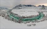
Saxon Switzerland is a national park with a stunningly picturesque mountain landscape, 30 km southeast of Dresden. It occupies an area of 9.5 thousand hectares on the border of Germany and the Czech Republic. Its neighbor is the Bohemian Switzerland National Park. Both parks are part of the Elbe Sandstone Mountains, which are part of the Eastern Ore Mountains.
Where does this name come from and what does “Switzerland” have to do with it. Until the 18th century, this area was called the “Meissen Plateau”. Swiss artists Anton Graf and Adrian Zing, who taught at the Dresden Academy of Arts, have chosen these places. The mountainous area above the Elbe with gorges, waterfalls and ancient castles reminded them of their native Switzerland and the Jura mountain range. Hence the name “Saxon Switzerland”.
We have come here for this beauty. 
In the 1800s, Swiss artists traveled here themselves and invited other landscape painters for inspiration and beautiful views. Masters of brush and photography travel to Saxon Switzerland even today. Throughout the park, through all the main natural and architectural attractions, one of the most beautiful tourist routes of modern Germany stretches for 112 km Malerweg, which means “Path of Artists”. It offers the most breathtaking views of the surrounding landscape. It is interesting that in 2016 it entered the top three most popular routes in the world.
In the 18th century, tourists and climbers followed the artists here. Shops, a restaurant, a hotel were opened for them. In 1824, the famous Bastei Bridge was built between the rocks. Today it is one of the most popular attractions in Saxony.
The most convenient way to get to the Bastei bridge is by car, it can also be done by S-Bann train to Raten or Wehlen, by bus from Pirna (No. 237, 238) and Bad Schandau (No. 253), or in summer by boat from Dresden. If you are traveling by car, it is easier and faster to get to the Saxon Switzerland park through the town of Lomen. Which is what we did.

We followed the signs to the parking lot near the main entrance to the park. The cost of parking is 3 euros. Entrance to the Saxon Switzerland park is free. The fee is taken only for a walk through the remains of the 13th century fortress Neurathen. These are bridges between the mountains further than the Bastei bridge. The price for 4 of us is 12 euros.
Helpful advice: for a walk in Saxon or Bohemian Switzerland, comfortable clothes, buried shoes, water are required, and in summer a headdress is desirable. Although it was hot, we all changed into sports sneakers. There are many rocky paths in the parks.
Next to the parking lot is the entrance to the Saxon Switzerland National Park. There are information stands with maps and information about the park in different languages.


We turned off the main road onto a side path. This is such a breathtaking panorama. Mountains of such an elongated shape with a flat top and steep edges are called table mountains. One hundred million years ago, during the Mesozoic era, this place was an ancient ocean. Sand settled to the bottom for hundreds of meters and in several layers. When the ocean waters left, the volcanoes split the sandy bottom into many pieces. Water and wind completed the formation of a unique landscape.

The main path led us to the hotel, souvenir shops and restaurants. In 1812, the first restaurant was built near the Bastei bridge, a little later, the Berghotel Bastei. This hotel has a rich history and an excellent reputation. Today the Berghotel Bastei is the winner of numerous awards. It is considered one of the best in Saxony.

Even for dogs there is a service)))

Behind the restaurant and the hotel, several rocky paths begin, they have many steps, all equipped with railings. Although you walk between the peaks of the mountains, you feel safe (this is information for those who are afraid of heights))). And you look down and around - it takes your breath away from the unreal beauty.
First of all, we went to the observation deck with stunning “postcard” views. It is located on a high cliff, which rises 194 meters above the Elbe. This is what we wanted to see when we planned our trip!

The people on the court are like herring in a barrel. We made our way to the railing. A “dream photo” in the background and alone is a rare success here. And this is on a weekday. Where without a “pink blouse” in the background))).

In the distance, Mount Lilienstein is the largest table mountain in Saxon Switzerland. To its right, on a smaller mountain, rises the fortress of Königstein, a powerful fortification of the 12th century. At different times, it served as a defensive fortress, a monastery, a prison, a prisoner-of-war camp and a place for storing paintings of the Dresden Gallery during the Second World War. In Königshtat, the alchemist Johann Betherr, a prisoner of the fortress, imprisoned in it by order of Elector Augustus the Strong, invented the first European porcelain in 1709. From this began the production of the now famous Königstein Fortress - a popular tourist attraction in Saxony.

The picturesque bend of the Elbe. Below you can see the ferry crossing and the two banks of the city - the Rathen resort. This small ancient town is a climatic resort. Here is the cleanest air, a calm atmosphere, the unique nature of Saxon Switzerland with mountains, waterfalls, Amselsee lake, rhododendron park, not far from the ancient fortresses of Königstein, Stolpen and Lomen, waterfalls, the Bastei Bridge, the Miniature Railway attraction, the summer Rathen theater among the rocks.

The ferry in Rathen is a unique, environmentally friendly mode of transport that still operates on a technology invented by the Dutch in the 17th century. It moves without a motor and without exhaust gases polluting the nature. This is a rope ferry. It is held on a long cable, which stretches several hundred meters upstream along the river and is fixed near the shore.
The ferry runs regularly from one side of the Rathen to the other. This is convenient for independent travelers who come here by train. by boat from Dresden or stopped at Rathen hotels. To get from Rathen to the Bastei Bridge, you need to cross the Elbe by ferry. A ferry ticket costs 1 euro (det. 0.50 euros) one way, in both directions - 1.8o euros (det. 0.80 euros). Further along the famous “Path of Artists” you need to climb to the Bastei Bridge. The climb up the steep path with numerous steps can take 30-60 minutes, depending on your fitness level.

And we continue to walk along the paths and steps of the park. Another bridge and a wonderful panorama of Saxon Switzerland.

Does the color of these mountains remind you of anything? The famous noble shade of palaces and churches! They were built from Saxon sandstone, which was mined in this area. The extraction of the stone proceeded at such a pace that the existence of Bastai and its environs was threatened. In the 18th century, people stood up to protect the unique mountains. Reserves were gradually created, and after the fall of the Berlin Wall and the unification of Germany, this territory was united into the huge Saxon Switzerland National Park, and in the neighboring state, the Bohemian Switzerland National Park. Now the original natural landscape is under the protection of the state, and sandstone mining is regulated by law.

The famous Bastei bridge rises 40 meters above the gorge. Its 7 arches organically fit into the mountain landscape. The length of the bridge is 76.5 m - such a long observation deck with magnificent views of the surroundings! The first wooden bridge was built on this site in 1924. Over time, it fell into disrepair, it became dangerous to walk on the boards. Within two years, in 1854, a new stone bridge was built from local sandstone. 
The Bastei Bridge is one of the most visited attractions in Saxony. There are always a lot of tourists here.

The original round observation deck on the bridge. Miraculously photographed without tourists in the background))


There are plaques on the rocks.


On the other side of the Bastei bridge, behind a wooden palisade, are the remains of the 13th-century Czech castle Neurathen. (Entrance here is paid - 3 euros). He guarded the borders of the Czech Republic and trade routes on the Elbe. It was one of the largest impregnable fortresses of that time. It occupied an area 700 meters long and 100 meters wide. Fortifications were built on the flat tops of the rocks, connected by log bridges. There was also a drawbridge here. The castle was destroyed by fire in 1469. Since 1485, it passed from the Czech Republic into the possession of the Saxon Margraviate of Meissen. Now almost nothing has survived from it: the remains of walls, an ancient water storage, a catapult and large stone cannonballs, which were once fired upon by enemies from the height of the fortress.
From the castle paths of the Neurathen fortress (pictured right), amazing views of the surroundings open up. 
Beautiful pictures of the nature of Saxon Switzerland and from the Bastei bridge.


Saxon Switzerland is very popular among climbers. Can you see the climber? 
And he is))

Although there are many tourists here, so sometimes there was a traffic jam on the paths, but the park is definitely worth a visit. Saxon Switzerland is very cozy, beautiful and unusual.
We are moving towards the next destination of today's itinerary - Czech Switzerland. The road passes through the resort town of Bad Schandau. It is known for excellent rehabilitation and health resorts, Wellness centers, healing thermal baths, good resort hotels. Interestingly, Bad Schandau is the smallest city in the world with a tram. Even in Bad Schandau (ul. Dresdner Str. 2 B) there is an information center of the Saxon Switzerland National Park. This is an interactive exhibition that tells about the flora and fauna, about the history and modernity of the park.
We drive into the city of Bad Schandau.

The road runs along the Elbe.

We stopped at a local supermarket, bought German beer and goodies at good prices. For example, a 0.5 liter bottle of the famous Saxon beer Radeberg costs about 0.50 cents. For comparison, a bottle of Coca-Cola is twice as expensive)) 
Here is the view from the parking lot of the supermarket to Elba.

And here we are again in the Czech Republic. Former checkpoint on the border between Germany and the Czech Republic. Now the Elba is changing its name - it sounds in Czech “Labe”))) The road here is very picturesque: on the one hand, the waters of the Labe River, and on the other, the rocks of the Elbe canyon rise.

Bohemian Switzerland, or Lost in the Lost World.
On the border with Germany, there is an equally beautiful “neighbor” of Saxon Switzerland – the Bohemian Switzerland National Park. This is part of the Elbe sandstone mountains in the Czech Republic. Stunning nature, unique mountain landscape, deep gorges, caves, clean air, silence, many hiking and cycling routes, ancient castles and authentic houses, fabulous sculptures and local legends - this is what Bohemian Switzerland is rich in.
We arrived at Hřensko (Grzhensko, Czech Republic). It is called the gateway to the Bohemian Switzerland National Park. The town is located 55 km from Dresden, 130 km from Prague, 40 km from the Bastei Bridge in Saxon Switzerland and only 10 km from Decin, where we plan to stay for the night.
What is unique about Grzhensko: This is the lowest area in the Czech Republic. The city is located only 115 m above sea level, although thanks to the surrounding rocks, there is no such feeling. The nature and climate around Grzhensko are also unusual - mountain plants feel great in the lowlands. Exotic adds that in this town there are more Chinese than local residents. What are the Chinese doing here? And they sell souvenirs and Chinese clothes.

Grzhensko consists of almost one street along the small river Kamenice, which flows into the Labe.

The architecture of the old houses of Grzhensko is very colorful. Next to the luxurious palaces - hotels of the XIX century, here under the overhanging rocks there are neat older rural houses.

The town was founded here in the 15th century. The great Czech trade route ran along the Elbe. At first, there was a tavern on the site of Grzhensko, where merchants and tree rafters stopped by to rest and eat. Later, workers built huts near the grain and timber, salt and glass storages. From the 17th century, Grzhensko became a major trading town. In these places, they harvested and processed wood, ground grain in three large mills, mined sandstone, traded in mushrooms, salt, charcoal, and even traded in smuggling. In the summer of 1838, the first steamboats began to run along the Elbe.
On the left in the photo are the ancient buildings of Grzhnesko and the church of St. John of Nepomuk, built in 1787. 
Only in the 19th century, the enterprising owner of the pandom, Prince Edmund Clari-Aldringen, realized how attractive his land was for tourists. He began to actively develop the tourism industry. In the 1830s, hotels and inns were built in Grzhensk. In 1862, a company appeared in the city that sold photographs and postcards with the sights of Grzhensko.
In 1879, the Bohemian Switzerland Mountain Society was created. Its members built and equipped with railings, steps, benches, bridges hiking trails and viewing platforms, also published popular magazines, and held meetings. In 1898, two gorges with boat crossings were opened to visitors. During World War II, a branch of the Nazi aircraft factory worked in the adits of Grzhensk. The town and park of Bohemian Switzerland was revived for tourists after 1964, when trails and gorges were reopened after reconstruction.
One of the famous attractions of the park - Pravchitsky Gate, or Pravcicka Brana, in Czech - Pravcicka brana. This is a huge sandstone arch, which was formed millions of years ago by natural "sculptors" - volcanoes, water, wind. Its maximum height is 21 m. An 8-meter arch bridge connects two sandy mountains. The trail to Pravcicka Brana has been open to tourists since the 1830s. Interestingly, the famous storyteller Hans Christian Andersen climbed here.
Near the castle "Falcon's Nest" 1881 Former summer residence of Prince Edmund Clary - Aldringen, the founder of the tourist destination in the development of Bohemian Switzerland. The castle was erected in a year by Italian craftsmen on the site of a wooden pub. Now here on the second floor there is the Museum of the National Park, and on the first floor there is a restaurant in which the original wall painting has been preserved. From the Pravchitskaya bran, a wonderful view of the surroundings opens up.

Many sources claim that this is the largest "natural bridge" in Europe and the world, but we have seen more on. On about. Gozo has the Azure Window. The stone arch rises 28 m above the sea. The numbers sound dry, but nothing compares to the delight and surprise when you see such an incredibly powerful and majestic natural structure nearby.
 Malta, about Gozo, Azure Window
 Today we have already admired the mountain landscape from the Bastei Bridge in Saxon Switzerland, so for a change in the remaining half day we decided to take a walk along the bottom of the gorge Edmund And go boating on the river Kamenica.
Practical information about Czech Switzerland:
Mandatory - comfortable clothes, closed sports shoes, a hat in the summer, water with you.
Entrance to the Bohemian Switzerland Park is free. For boats and Bran, payment is accepted in kroons and euros.
- Pravcicka Brana
Price walks along the paths and observation decks of Pravcicka Brana - 75 kroons (3 euros) - adult, 25 kroons (1 euro) - children's ticket.
- Edmund's Gorge
Working hours: From April to September, boats operate from 9:00 to 18:00, in October - from 9:00 to 17:00 every day. The last boat in the direction of Grzhensko departs at 18:00, and towards Mezna at 17:30. (in October, respectively, an hour earlier)
Cost of skiing on the boat: 80 kroons (3 euros) - adult, 40 kroons (1.5 euros) - children's ticket.
- Wild Gorge
Working hours: From April to September from 9:00 to 17:00, in October from 9:00 to 16:00 daily. The last boat in the direction of Grzhensko departs at 17:00, and towards Mezna Luka at 16:30 (in October, respectively, an hour earlier)
Boat price: 60 kroons (2.5 euros) - adult, 30 kroons (1 euro) - children's ticket.
How to get to Grzhensko by public transport: Regular buses from Decin (on the way 15-20 minutes) and Bad Schandau go here almost every hour. They can also drive deep into the park, to the villages of Mezhna or Mezhni Luka, from which hiking trails begin in the park. You can also swim by boat from the city of Decin, from the German cities of Bad Schandau, Dresden and Meissen. These cities are easily accessible by train.
Buses run through the park, stops are marked on the map with a BUS sign.
Parkings: Grzhensko has 4 municipal car parks and several private ones. All of them are shown on the map. Parking fee: 30 kr (1 euro) per hour, 120 kr (4 euro) per day.
Hotels in Czech Switzerland: There are hotels and pensions in Grzhensko and the surrounding villages of the park. At the same time, you will stay in the heart of Bohemian Switzerland and be able to enjoy nature, tranquility, active hiking and cycling tourism. You can book accommodation through this link:
See also special offers with discounts of hotels in Czech Switzerland.
Here is the most difficult moment for those who travel to Czech Switzerland for the first time. And if everything is certain with Pravchitska Brana (except for travel time), then we “hit” with the gorges. We will show you all the best walking routes on the map. In the meantime, let's talk about our adventures in Czech Switzerland. We named them "Lost in the Lost World".
We put the car in the first parking lot. A pleasant woman, an usher, who understood Ukrainian perfectly, presented us with a plan-map of Czech Switzerland. We warned that we would park for 2 hours. (According to the map... Oh! Optimists.!))) She smiled and said that this was not enough, but you could pay extra for parking later.
Here is a map of Czech Switzerland that we received. It is in German and Czech.

When we were planning a route in Czech Switzerland, we read the reviews of other travelers. Many walked in a big circle: from point 1 - through all points - to point 6. Everyone wrote that the walk takes a lot of time, but no one specifically said anything, it looked something like this: "passed, looked." The only thing they wrote is that everything is done in a day. But since we arrived in the afternoon, and were in the mountains of Saxon Switzerland, we decided not to inspect point 2 (Brahma). We wanted to walk through the city of Gzhensko from point 6 (parking) and take a boat ride in the Edmund Gorge between points 5 and 4. And then return the same route or walk to a stop in the village. Mezhna and come to the parking lot by bus.
"Pitfalls" of thisarts .
- It does not indicate where the ascent or descent is, which is inconvenient when planning a route.
- Distances in km are shown only on roads, and ALL walking routes are measured in MINUTES, not meters or kilometers. Here is the "trick".
Practice has shown that it actually takes at least two to three times more time to walk along the route than it is written on the map. Also keep in mind that on the way it takes a little time to take photos - pauses, because there is amazing beauty around.
3. How does a person feel when expectations are disappointed? Unpleasant feelings of confusion, fatigue from expectation and irritation from the fact that in reality everything is not so. These are our feelings during the passage of the second half of our route, when the information on the map did not coincide with reality at all. Therefore we were "Lost in the Lost World".
And now everything is in order. Our example of what route not to take. “You don’t go there, you go there, you go there”)))
Grzhensko is an interesting town. With pleasure we walked along its only street, looking at the houses and funny garden figurines that are sold along the road.

We are looking forward to it. Behind the bridge and the Pension Soutěsky hotel (on the right in the photo), a beautiful path to the gorge begins. The car could have been parked here, but this way we had a better look at Grzhensko.

At the beginning of the trail there is an information stand with a map, distances, timetables for the boats and their last departure, so that the tourist does not walk in vain. Everything is written optimistically))) Here you can see that the first yellow section 1 km long takes 20 minutes. In city mode, we walk faster. But here something went wrong. We walked it to the gorge and the boats in 50 minutes (this is true from the parking lot, from it - 1 km).

We crossed the bridge over the river Kamenice.

After it begins the forest path. It is equipped with railings, steps, benches.

Interestingly, until the 19th century, the mountainous area with gorges along the Kamenitsa River was called End of the world. When the trails ended, the locals were afraid to go further into the dense forest, full of secrets and legends. Well, why not a fabulous Lost World ?!


The surroundings are incredibly beautiful.

Here you want to sit down and just enjoy the tranquility, the murmur of water, the singing of birds, the greenery of the forest in the sun.

And the forest path along the stone gorge along the river does not end there.

Well, finally - you can see the place of landing on the boat. Further, the trail is interrupted and you can move along the route only on the water.


The history of these boats and the gorge of the Kamenitsa River began with a dispute. In 1877, five daredevils, after having a good drink in a Grzhensky tavern, made a bet that they would float on a stormy river on rafts. Three rafts confidently covered the distance. After that, the owner of local lands, Prince Edmund, hired Italian workers and built paths, bridges, tunnels, dams. In 1890, boating was opened for tourists along the first 500 m long gorge. At first it was Quiet, now it was named Edmund's Gorge in honor of the prince. A few years later, a second one was equipped - the Wild Gorge, the length of the route along it was 250 m. Then the tourists were taken on boats by ferrymen in beautiful uniforms of sailors.
Today we will sail through the first long Edmund's Gorge. Bought tickets at the box office. Tickets for our family cost 9 euros. The walk takes only 20 minutes.

We ask the cashier what we should do, how far and how long after the boat to point 4 - p. Mezhna? He says no, it's close. Indeed, a zigzag is drawn on the map on the green left route and 15 minutes is written. We had two options: 1. Go back by boat, again pay 9 euros and again walk 50 minutes to the parking lot. Or 2. - see more of Czech Switzerland. We chose the second option: after the boat, walk 15 minutes and 500 m (according to the map) to the village of Mezhna, take a bus there and return to the parking lot. (You could still go further along the yellow route, sail on a boat along the Wild Gorge and go to the village of Mezhni Luka and the bus, but it would have been much longer).
The boat trip was very nice and soulful. The boatman in three languages (eng.czech.rus.) told funny and funny stories about the gorge, mysterious legends.

Local fabulous inhabitants looked at us from the shores. Good and not so good


And where there were no sculptures, everyone unanimously turned on fantasy. After all, the outlines of rocks and stones are very similar to fairy-tale characters.

Do you see the snake?

The boatman pulled the rope and a waterfall poured from the walls of the gorge. Pulled a second time - no waterfall.

The walk turned out to be interesting. We arrived at the boat station. There is a restaurant on the pier. Here you can eat and relax.

Prices in Czech crowns.


On the way they washed and refreshed themselves in the river.

The path leads through the tunnels.

These tunnels were cut in the rock by workers specially invited from Italy. They were called Barabbas. They were famous mining masters in the Alps. In the formation of tunnels, a special technology was used - in winter the rocks were heated, then cooled sharply with water. So the stone walls cracked and succumbed to processing.


This place reminded me of another stone gorge in Austria - Liechtenstein. Read about it here:

It turned out that we were waiting for the rise, remember the zigzag on the map? It was not an easy climb, but a very steep and long one. It feels like we've climbed a skyscraper. And we walked in a serpentine on such stairs.


Well, we think we'll be patient, we'll get on the bus soon. But when the stairs ended, the ascent continued along the forest paths anyway. 15 minutes have passed a long time ago, but the end is not visible)) We looked back, down there - the gorge of the Kamenitsa River. 
And when we finally reached the village of Mezhna, to a restaurant, our strength finally left us. Time from the boat station to this finish line again took 50 minutes. They spent 30 difficult and long minutes on the ascent, and 15 were announced. 
According to the map, there should be a bus stop here. But the restaurant waiter and a few people in it knew nothing about it. Strange! We nevertheless found a stop at 100 m. We sat, rested, waited. We saw the timetable and realized that buses run very rarely here and the nearest one is 3 hours. We decided to go to the village of Mezhni Luka - it's about 2 km. The asphalt road went through a flat, beautiful area.

When we arrived at another stop in the village. Mezhni Luka is next to the parking lot, read the schedule and realized that there would be no more buses today))) And it’s another 6 km to stomp to Grzhensko. There was no more strength to go, everyone was tired. They thought to include a “plan B”: I need to hitchhike to the parking lot and return for my own in our car. We went to the main road. And then another stop was found in front of the Mezní Louka hotel, and many tourists were waiting for the bus there. Hooray! We are saved! While waiting for the bus, the children had fun

We took the bus to our car. Our walk through Czech Switzerland took about 3.5 hours. Adventures we will never forget! Now we remember with laughter))) But only thanks to such a difficult walk, we will be able to help other travelers plan a route through the park. Organized tourists are not brought here, because it is impossible to collect them afterwards))) After all, it is easy to become “Lost in the Lost World”))) here. Of course, if you do not know how to optimally and correctly build a route.
Routes in Czech Switzerland.
There are many walking and cycling routes in the park. It is difficult to get lost - there are many signs everywhere. There are buses on the main roads marked in white on the map. Stops - icon BUS on the plan. You can combine a walking route with a bus ride. We will show on the map the routes to the main attractions of Bohemian Switzerland.
Route to Pravcicka Brana.
This route is for those who want to enjoy the mountain scenery of Bohemian Switzerland. On the map - point 2 And brown route. At the turn off the main road - a sign for Pravcicka brana. Nearby - paid parking and stop "Three sources". From here it is optimal to start the ascent. The length of the route from the turn to Bran is 3 km, on the map the duration is 45 minutes. In fact, expect the climb to take an average of 1 hour and 20 minutes with photo breaks along the way. The whole route together with a walk along Pravcicka Brana and returning the same way It may take approximately 3.5 - 4 hours. (If you go from Grzhensko - paragraph 1 or point 6- add distance and time to the calculation.)
From Pravchitska Brana there is a path to the village of Mezhni Luka, point 3. Length - 7 km, travel time about 2.5 - 3 hours. It will be overcome by physically prepared travelers.

Route to the Gorges.
It is suitable for those who want to see the “Lost World” of the Kamenitsa River and go boating in the gorges. But you will also have to walk a lot)) We will divide it into three options: 1. Easy option Edmund's Gorge (+ optionally Wild Gorge), 2. Edmund's Gorge, 3. Wild Gorge + Edmund's Gorge.
Option 1 - Easy and simple route through the gorges with boating.
A) The path that we did at the beginning, but with the return of the same road back. Will go for a walk average 2.5 hours without taking into account the time for rest in the restaurant. yellow route on the map: from Grzhensk points 6, 1 and 5on the map follow the forest path to the boat station in Edmund's Gorge point 4-B. Travel time is approximately 50 minutes. You sail on a boat for 20 minutes one way, relax in a restaurant (optional), return by boat - another 20 minutes. Walk back to Grzensko - about 50 minutes.
B) You can supplement your walk with a boat ride in the second - Wild Gorge point 4-A.In this case, expect that for the entire walk through the two gorges you need about 4 hours, excluding rest in the restaurant. From the station in Edmund's Gorge to the boats of the Wild Gorge, go 30 minutes there and 30 minutes back. The boat ride takes 15 minutes there and 15 minutes back.
*** When planning a route, carefully read the boat schedule and find out the time of the last departure of the boats in the direction of Grzhensko.
Option 2 - Edmund's Gorge route.
This short route is our traveled path in reverse)). On the map - white +yellow route: point 3 With. Mezhni Luka - point 4 With. Mezhni - paragraph 4 - B point 5 about 3 hours.
By bus you reach the village. Mezhni Luka - point 3(and if you are lucky with the bus, then to the village of Mezhni point 4). If you are by car, it is better to park it at the Grzhensko parking lots ( paragraph 1 And point 6) and before the start of the route in with. Mezhni Luka go by bus. From s. Mezhni Luka ( point 3) go 2 km to the village. Mezhni ( point 4). There will be an easy ascent on an asphalt road. Travel time is about 40 minutes. Further behind the restaurant, following the signs to “Soutěska” (which means “gorges”), go down for about 20 minutes along the path down to point 4-B.
Behind the bridge over the river there is a fork with signs to two gorges. You turn right towards Edmundova soutěska. It takes about 15 minutes to get to the boat station and the restaurant. Relax and buy tickets. The boat sails along the Edmund Gorge for 20 minutes.
***
point 5, 1, 6
Option 3 - Route Wild Gorge + Edmund's Gorge.
A longer route, compared to the first option, includes boating through two picturesque gorges in Bohemian Switzerland. On the map - blue +yellow route: point 3 With. Mezhni Luka - point 4-A Wild gorge and boat station - paragraph 4 - B Edmund's Gorge and Boat Station - point 5 Grzhensko. Total travel time - about 4 hours.
From s. Mezhni Luka ( point 3) follow the signs to Divoka soutěska. The descent by road will take approximately 30 minutes. Then turn right onto the path along the river to the Wild Gorge. Follow the signs for another 30 minutes. Buy tickets at the boat station. The boat sails along the Wild Gorge for 15 minutes.
*** Be sure to note that in the summer the last boat in the direction of Grzhensko departs from here at 17-00, in October - at 16-30, in October an hour earlier. If you do not have time, you will have to climb back to the village. Mezhni Luka, because further along the gorge you can only move by boat, there are no paths along the coast!!!
It takes about 30 minutes to walk to the next boat station in Edmund's Gorge and a restaurant. Buy tickets and relax. The boat sails along the Edmund Gorge for 20 minutes.
*** Be sure to note that in the summer the last boat in the direction of Grzhensko departs from here at 18-00, in October - at 17-00. If you do not have time, you will have to climb back to the village. Mezhni, because further along the gorge you can only move by boat, there are no paths along the coast !!!
After the boat, follow the forest path to Grzhensko ( point 5, 1, 6). Travel time with photo breaks is about 50 minutes.
Tourists in excellent!!! physical fitness really pass the entire route in Czech Switzerland
from paragraph 1 And up to point 5 in a day, visiting Pravcicka Brana and the gorges. But it's better to break the path into 2 days))
Decin. Czech Republic.
We stopped in the ancient Czech town of Děčín. It is only 15 km from Grzensko and Bohemian Switzerland. The city was founded in 993 by the princes Přemyslids - the first kings of the Czech Republic. We wrote about them in this article about Prague:
By the way, information for tourists without a car, the Prague-Dresden railway line passes through Decin. And from here it is convenient to get to Czech Switzerland by bus or boat.
Decchin was examined from the car window. Very cute old town.

We are approaching the central squares of the old town.

And this Decin Castle, erected in the XIII century over the river Labe. This is the main attraction of the town. Since the 19th century, the castle has been the cultural center of the region. It was owned by representatives of the influential family of Tuns. Many eminent writers, artists, composers were received here, among them Walter Scott and Frederic Chopin, who wrote the Decin Waltz. Guests were impressed by the huge orchid garden. It was considered one of the largest in Europe. Now on the alleys of the castle you can see a beautiful rose garden - Decinsky rose garden.

We booked these apartments near the Decin Castle - Czech Switzerland Castle Apartments.
Studio apartment in an old house on the 3rd floor, with a kitchen and free parking in the yard. There is an elevator to the floor. The apartment we booked has a balcony. In the photo - on the right. On it are light green chairs.

We were met by the owner - a pleasant cheerful guy David, showed us the accommodation and talked about the most interesting sights of the city and its environs. I liked the apartment very much. Everything is clean and tidy, original interior.


On the ground floor there is a cozy cafe with sweets and drinks. Babies are splashing happily in the fountain. Across the road is a small lake. View from our balcony.

We view the Decin Castle from the balcony of the apartment. I didn’t have the strength to visit him at all))) It’s a pity that we underestimated the tourist potential of Decin and stayed here for just one night. The city also has a zoo, a water park, ancient buildings, ancient bridges, 15 km away - the largest mountain in Czech Switzerland - Decinsky Snezhnik. David has a lot of brochures in his apartment describing the routes and sights of Decin.

I only had enough strength to go to the supermarket to replenish food supplies for the next day and buy something for dinner and breakfast. But even on the way to the supermarket and back, we managed to go around the lake.

On the opposite bank from the apartment, they found the Fabrika restaurant, which David recommended.

But we have other plans for this family evening: Czech dumplings, cold German Radeberg beer and a gorgeous view from the balcony. 
The next day we are waiting for the road to Budapest with a stop for 3-4 hours in the capital of Slovakia, Bratislava.
On the border with Germany, one would like to write, in the dense forests is the Czech Switzerland National Park. It seems that in Europe all the places where beautiful nature bears the name of Switzerland, only the adjectives change. So in the north of the Czech Republic they did not deviate from traditions. National Park "České Švýcarsko" (this is how it looks in Czech) is famous for its extraordinary beauty of high steep cliffs, murmuring streams. Against the backdrop of such beauty, one natural monument stands out, which is the hallmark of this area. We are talking about the Pravchitsy Gates. This is a rock-hole, as we would call it, the largest natural gate from a rock mass on our continent. For their sake, hundreds of thousands of tourists are sent here.
Of course, when so many people gather in one place, it’s a sin not to organize walking routes and attractions with which you can earn money.
Boating with helmsmen, who control the vessel with the help of poles, along the gorge is another entertainment that attracts tourists.
According to those who have passed this route, it is better to start it from the village of Mezni Louka. Along the route marked in blue (marks on the trees in blue) we descend to the Divoká Soutěska canyon. The markers start right behind the Mezní Louka hotel. This option is convenient because most of the road will go downhill. We took the harder route.
It began for us in the village of Hrensko. Even before he had time to put the car at the entrance to the settlement, his mouth opened arbitrarily from the beauty he saw. High sheer cliffs hung directly above the road. At their foot, wherever possible, houses with restaurants were attached. Under one of these rocks was a parking lot, where the car was left.
Before starting the route, let's look around and enjoy the moment. Next we will have a walk along the river Kamenice. To correctly navigate, remember the movie The Diamond Arm. The action will take place at the toilet. On the map marked with the letters M and ZHO. Everything is very similar here. Near a huge rock there is a low building with the same letters. If you go to the left of the cliff, then you will meet with the Pravchitsky Gate, and if to the right along the river, then you will sail on a boat with an uncle who has a big pole.
Since the guys swim only until six, and we arrived after dinner, we decided to start with them.
The first part of the gorge is pedestrian. Twenty minutes along the path, sometimes just above the river, sometimes descending directly to it. The rocks are so close that the hands reach for them. Somewhere for convenience, pedestrian tunnels were made. Children from such a neighborhood are a joy. Together with adults, they play echo, screaming loudly inside. So with jokes and jokes, they didn’t notice how they plowed two kilometers. As soon as the dam appears ahead, you can already relax and slowly walk to boarding the boat. This part of the rides is called Edmund's Gorge (Edmundova soutěska). The session will last approximately 15-20 minutes. A lot of interesting chips made for tourists can fit in this short period. It is a pity that fluent Czech is not quite, or rather, completely incomprehensible to the Russian ear. According to the stories of linguists, the boatman leads his unhurried story about the route and the history of this place. In the most unexpected places, a dragon's head crawls out, a boletus peasant sits on a mound, a rock in the form of an open mouth, and much more. For convenience, the places where you need to look at outlandish rocks are painted yellow. And the crown of this story is an unexpected "by itself" turning on the waterfall (for this, a wire is stretched at the top).
The freebie ended quickly and again you need to work with your feet. First, in light mode along the river to the bridge. On the way, right behind the high-rise from the boat, you will meet a small cafe where you can have a bite to eat. True, I do not advise you to do this, since the most difficult section lies ahead. It starts right after the bridge.
Before proceeding, I will make a small digression. The difficult section after the bridge begins for those who want to shorten the route. If you go to the maximum to the end, then after the bridge you need to move further along the river until the next landing in the boat. The boat ride will pass through the Wild Gorge (Divoká Soutěska). Then it will be necessary to climb up the mountain from the gorge and reach the village of Mezni Louka. Then, along the yellow tourist road called Gabriela's path, you need to climb the road along the rocks to see the rock massifs: Big Pravchitsky cone, Homole sahara, Krshidelni wall. Ultimately, this path will lead us to the Pravchitsy gates.
We, unfortunately, did not have so much time and from the bridge we started the most difficult part of our journey. From the very bottom of the gorge, a steep climb awaited us. For those who are not physically fit, a serpentine trail has been made. We were going through. The twenty-minute climb ends at the hotel-restaurant. Here you can rest a little bit and drink a cup (beer). This small settlement is called Mezna.
Then you need to get strictly in a straight line to the road leading down to the highway 25861. This part of the route is marked in yellow. The road will go first through the field and you can see a rocky ridge, along which there is a longer route. If you got on it correctly, then you will go straight to the bus stop, from which another ascent to the Pravchitsy Gate begins.
The ascent itself is initially not very interesting until you reach the section along the rocks. Giants soaring up to a height of 30-40 meters hang over you. You are so small compared to them, moving further and further. When they end, you think that's it. However, no, this is only half, because bypassing the stone you begin to move in the opposite direction. How long is short, but in ten minutes the last jerk and here is a huge rock with a hole inside. This is not just a gate, it is a whole flyover across the gorge, but no, it will be more abruptly than the bridge across the Bosphorus Strait. Of course, taking into account the fact that it was nature itself.
Next to the gate is the Falcon's Nest castle, built in 1881 in the Alpine style. Previously, local hosts accommodated their guests here. Now there is a restaurant on the ground floor, and a national park museum on the second. To get to the gate you need to bypass the castle and pay money. We didn't make it. The gate slammed shut in our face. It remains only to admire the gate and take a few pictures.
The way back was no longer fun. By this time, fatigue from the route and the morning distance of the race had an effect. The route ended in a cozy restaurant near the water mill in the village of Grzhensko.
When the weather is good on weekends, many Czechs, especially residents of large cities, flock to nature. At the same time, they go there not to drink and eat, but to take a walk or ride in beautiful places. We also try to maintain this tradition and go for walks in parks or forests. The recent weekend was no exception, and we went for a walk in Bohemian and Saxon Switzerland.
Bohemian Switzerland is one of four national parks in the Czech Republic, which is located right on the border with Germany. Crossing the border, you immediately find yourself in the German national park Saxon Switzerland. The main objects of protection of the park are unique sandstone formations. Here you can find massive stone towers, arches, labyrinths, which were formed due to centuries of erosion. The most famous rock formation is the Pravčická brána, which is the main goal of our walk.
Leaving Prague early in the morning, passing and crossing the bridge over the Elbe, we find ourselves in the town of Hřensko, where we leave the car in the parking lot between the rocks. Grzhensko is a village with a population of only 200, which is located on the banks of the Elbe, and from which it is closest to get to the Pravcicka Gate. The distance from Grzhensko to Prague is 130 km.
Parking costs CZK 120 per day. There is a catastrophic lack of parking spaces, if someone leaves the car right in the middle of the road, then they write out a fine and put a wheel blocker.
In addition to the car, you can get from Decin to Grzhensko by bus, the travel time is about 30 minutes. In the summer months, there is still a boat from Decin, which also reaches the German city of Bad Schandau. It is most convenient to get to these places from Prague.
If you want to stay in Czech Switzerland for the night, then only in this area there are about 10 hotels and pensions. The Forest Garden Hotel is the most decent hotel in the area and is very popular due to its cleanliness, modern design and quiet location.
Not far from the parking lot there is a fork in the paths, along one of which we go to the ascent to the Pravchitsky Gate, along the other we can reach the place where the boats depart along the Kamenitsa River. During the boat trip you will see the waterfall and enjoy the local beauty without straining your legs.

Dawn meets in the forest. Forests cover 97% of the park's area, which is 79.23 km². Forests have helped these places to develop, since it was the processing of wood that became the main activity of the indigenous population. After all, the wood produced at local sawmills was supplied to the shipyards and used to build the masts of sailboats.
Initially, beech forests dominated the territory of the current park, now spruce trees mainly grow here.

During the walk, there were signs reminding that it is forbidden to launch drones throughout the park. The fine for launching a drone can be up to 200,000 Euros.

And so we reached our goal - the Pravchitsky Gate. Travel time from the parking lot at an average pace uphill is a little more than 1 hour.

In 1881, a small castle was added to the rock formations, which is called the Falcon's Nest (Sokolí hnízdo).

Entrance fee to the territory of the Pravcicki Gate and the castle: 75 CZK. Entrance fee for children, students and pensioners: 25 CZK.
On the observation deck there is a restaurant and separate tables where you can have a picnic with your products or buy sausages, soup, beer or any other hot and cold drinks in the tent. If you do not want to eat here, then in the town of Grzhensko there are at least 5-7 restaurants at boarding houses with Czech cuisine.

The views from the observation deck are quite nice.

Someone takes a selfie on the observation deck, and someone hones their climbing skills, fortunately, the local rocks are suitable for this.

The park is inhabited by 62 species of mammals. Wolves, bears, moose have been exterminated here for a long time. Now the park is inhabited by beavers, various rodents, roe deer and wild boars. Also in the park there are 227 species of birds, 1000 species of butterflies, but the number of fish species is very low, and the park administration is engaged in the revival of the fish population in local rivers. So, for example, more than 1,200 salmon fry were launched in just one year.
It is worth mentioning that Bohemian Switzerland is the largest nesting site for black storks and falcons.

With a width of 26.5 and a height of 16, the Pravcicka Gate is the largest arched rock formation in Europe. The gate has become a symbol of the park.

After a busy walk and a short picnic, we went to Saxon Switzerland, and we decided not to waste time on the rest of the sights of Czech Switzerland, since they are not very picturesque.
We learned about Saxon Switzerland quite by accident, Pasha came across an article describing a trip to Saxon Switzerland with impressive photos. I decided to see what it is and where. It turned out that the Saxon Switzerland National Park is located near Dresden, right on the border with the Czech Republic. And on the Czech side, the park is called Bohemian Switzerland.
The park is not very big, but it has a lot of trekking routes and you can easily spend at least a whole week. But thinking that a week of vacation is an unaffordable luxury, we decided that we would go to Saxon Switzerland somehow just for a long weekend.
How to get to Saxon Switzerland?
The easiest way is by car. In this case, moving between routes and attractions in the park will be easy and convenient. The only downside is that you need to plan either round trip or roundabout routes to get back to the car.
It is also possible to get and move around by public transport. On the German side, the nearest major city is Dresden, on the Czech side, Prague. Both of them provide easy access to the park. But on the spot, in order to get to the start of routes from the surrounding towns and villages, you will have to find out the schedule of local buses and trains.

Where to stay near Saxon Switzerland?
If you are by car, then this issue is not so acute. From any village you can easily get where you need to go.

If you are traveling by public transport, then on the Czech side, Decin (Děčín) or Hřensko are good choices. Decchin is larger, but from it you have to go to the park. But several routes start directly from Hřensko, including one of the most famous ones to Pravčická brána.

From the German side, there are several options. If you want to visit the Bastei Bridge and take a walk in its surroundings, Rathen or Bad Schandau are the best choices. If you want to walk along other routes of the park, then you need to choose something from the villages close to the route. Almost all have small family hotels where you will feel like a real German.

We had to stay two nights over a holiday weekend plus we were in a car and weren't tied to buses. After looking at the options on Booking.com and Airbnb (we wrote more about what airbnb is in the article Airbnb - what is it? How to use and how to book accommodation in any city?), we chose accommodation on airbnb in Decin, but for now we thought this apartment already passed. Therefore, the next suitable for the price, comfort and location was a room in a family hotel in the village of Česká Kamenice.


What to do in Bohemian and Saxon Switzerland?
1 full day - Czech Switzerland
The route starts in the village of Mezni Louka and gradually climbs towards Pravcicka Brana. On the way there is a beautiful forest, rocky walls, separate rocky remnants - in general, very beautiful!


Further Pravcicka Brana and the building of the 19th century - the Falcon's Nest. Entrance to the observation decks 75 CZK. On the official website you can check the opening hours and current prices www.pbrana.cz. Most can be viewed for free, so it's up to you to decide whether to go to the paid part.


After this trail, you can go to Mezni Louki through the forest, or you can continue along the canyon just like we did. There is a second route Divoká soutěska and a second crossing - it will cost 60 CZK. We really liked the trail, it passes almost over the mountain stream itself, sometimes overhanging. There are beautiful rocks all around. On the first section there is a waterfall attraction - they bring you to a wet wall, tell some fairy tales, it depends on the boat manager, and then ... suddenly a powerful stream of water falls from the waterfall in a fountain. Nobody expected this...


During the boat trip, you will see not only a waterfall, but also beautiful wooden figures, each with its own history, you will be shown interesting rock formations that look like something or someone. The second part is less interesting, simply because it repeats the first. Although ... Whether nature can repeat itself in such unusual forms is a moot point. From the end of the second trail for another 20 minutes and we go to Mezni Loki, right to the central parking lot. By the way, parking is the most expensive "entertainment" - 100 CZK / 1 day.


Also this route can be passed from Grzhensko. You can go in the opposite direction, but I do not advise this, since the rise from Grzhensko is long and monotonous, it is much better to go down quickly there.
2 day or half day Saxon Switzerland and the famous Bastei Bridge
Most often, the route to the Bastei Bridge starts either at the Basteistrasse (Basteistraße) - in this case, parking will cost 3 € / day plus 1.5 € / person shuttle bus to the start of the route. The second option is the village of Rathen, almost all large parking lots are located in most of the village on the other side of the Elbe and you will have to use the ferry to get to the start of the route.


In the part of the village of Rathen, which is located on the same bank with the Bastei bridge, entry is allowed only to residents and hotel guests. However, the car can be left in private parking almost reaching the village. The cost is 3€/day.

Before the start of the route 15-20 minutes through a pleasant forest. At first, the signs took us to Basteistrasse, after looking at the prices, we returned to the idea that we would leave the car in the village itself. But ... we saw a sign forbidding passage to non-residents. Nearby was a private parking for 3€, but it was almost all occupied. Cars were parked on the side of the road, there was no sign prohibiting parking. Of course, we parked and went to the Bastei bridge.

Bastei is a group of sandstone rocks that, under the influence of time and nature, have taken on very beautiful and unusual shapes. Bastei is also famous for the Bastei Bridge. The Bastei bridge was built in 1824 and was originally made of wood. In 1851, the Bastei bridge was replaced by a sandstone bridge, and it has remained so to this day.

If you have at least 3-4 hours, then you should go not only to the Bastei bridge, but also walk along the route further, go down to the Elbe and return to Rathen along the bike path.

We were not lucky on the first evening, the weather was not very good, and as soon as we began to climb to the bridge it began to rain ... Without thinking twice, we cast a cursory glance at the bridge and drove to the place to spend the night. The second attempt was in the morning before the trip home. The sun was shining and the weather was just perfect. But we had very little time, so we limited ourselves to walking to the Bastei bridge and all the observation platforms and back. This route took us about 2-2.5 hours of leisurely walk from the car. There is an optional paid section on the route, the cost is 2€/person. The route passes along bridges between rocks. There is a description of several historical details, though little of them remains. But beautiful views of the Bastei bridge and the surrounding rocks.

By the way, the most famous photos of the Bastei Bridge are taken from free viewing platforms. True, fog or beautiful sunset / dawn rays must be specially waited for. Although you might be lucky?
As a result, I would like to say that if you are in the vicinity, and you have a free 1-2 days, then you should definitely visit Czech and Saxon Switzerland!
Czech Switzerland is the name given to the northwestern region of the country in the upper reaches of the Elbe River, which borders on Germany. The Elbe Sandstone Mountains are located in this area. Since 2000, this area has the status of a national reserve. The area of the national park is about 80 square kilometers, and its continuation is located on the territory of Saxon Switzerland.
miraculous sights
The highest mountain in Czech Switzerland is Decinsky Sneznik, which rises to 723 meters above sea level. This indicates that this mountain range is low. Mountain formations arose millennia ago, creating an amazingly beautiful landscape: bizarre rocks, crevices, canyons. The most picturesque part of the national park is the canyon of the Kamenice River and the ancient artificial reservoir.

Particular attention is drawn to such an attraction of the park as the Pravchitsky Gates, which have become a kind of symbol of the reserve. They are natural gates made of rock and are the largest creation of nature of this type on the European continent. The span of this miraculous arch measures more than 26 meters, and its height reaches 21 meters.

The thickness of the rocky rock of the gate is also impressive, which at its narrowest point is 3 meters. The upper part of the arch is quite narrow, so access to its platform is closed.

Passing under the arch of the Pravchitsky Gate, along the paths and stairs you can climb to the observation platforms, from where you can see the stunningly beautiful landscapes of the mountain landscape.

"Falcon's Nest" and Dolskaya Mill
Nearby, almost under the Pravchitsky gates, there is a small castle "Falcon's Nest", built in the 80s of the XIX century. Today on the second floor of the building there is an exposition of the National Park Museum. The first floor is occupied by a restaurant with an originally decorated interior, where amazing murals have been preserved.

The Dolskaya mill is also a tourist attraction of the national park. These are preserved fragments of a water mill, the date of construction of which is said to be 1515. In the middle of the last century, the windmill served as a backdrop for the filming of the popular fairy tale film The Proud Princess directed by Bořivoje Zemana.

Over time, the building began to fall into disrepair, but recently it was mothballed, suspending the destruction. In 2007, the Dolskaya mill acquired the status of a cultural monument protected by the state. A few hundred meters from the mill, you can see a small bridge that was built at the beginning of the last century. It is a unique historical building, as it is the first object built of reinforced concrete on the territory of the Austro-Hungarian Empire.

To see the 180-year-old royal spruce, you need to overcome the path from the mill for about half a kilometer. The trunk diameter of the green beauty exceeds 3 meters, and it reaches almost 27 meters upwards.

Rock castle Schaunstein
Schaunstein Castle, built in the first half of the 14th century, is located on the territory of the park in a dense forest. It was built to protect trade routes. Over time, it lost its significance, and after the Thirty Years' War, robbers and deserters found shelter here. The castle received a different name: Lupezhnitsky. Now only ruins remain of it.

The upper platform of the structure, which is approximately 70 meters long and 20 meters wide, consists of several parts connected by bridges. The ruins give an idea of the impressive size and former grandeur of the castle. During the excavations, a part of the main tower of the structure was found, which could serve as a prison or storage room.

Viewpoints of the reserve
There are several observation platforms in the reserve, one of them is an old stone observation tower, which was erected on the top of Dechinsky Snezhnik. From here, as far as the eye can see, wonderful views of Bohemian Switzerland open up.

Another platform in the form of a huge terrace, as if hanging over the canyon where the Elbe flows. It is called Belvedere, and was built by the Kaeri Aldringen family, who owned most of the territory of Bohemian Switzerland. Until today, their coat of arms, carved right on the rock, has been preserved.
A visit to the Bohemian Switzerland National Park gives unforgettable moments of communication with the unique nature and monuments that make up the historical and cultural value of this land.