Island in the Norwegian archipelago. Senya Island. The saga of the changeable Norwegian weather. Things to do and see
Stretching in a thin jagged line in the Norwegian Sea, the Lofoten Islands are an excellent place to relax for a few days. It has a surprisingly mild climate for the north and a lot of accommodation in fishermen's houses (rorbuer), which are now well equipped and can accommodate 2-6 people. In addition, there are five hostels and many campsites in the Lofoten Islands. Hurtigrute coastal vessels call at the ports of Stamsund and Svolvær, and from Bodø proceed to the southern islands of Moskenes, Værøy and Röst. Slightly cheaper high-speed passenger ships are also associated with Svolvaer. Intercity bus service connects the mainland and the islands (from Bodø to Svolvær via Fauske and from Narvik to Svolvær).
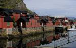
The town of Svolvær and the village of Henningsvær on the island of Eustvogøy
The main town on the largest of the northern islands (Eustvogöy) is Svolvaer, an unremarkable place where all the island's buses stop. Vessels from Bodø moor about 1 kilometer west of the city center, while Hurtigrute ships moor in the center, next to the bus station and tourist office, where you can get information about the island and find out the bus schedule (from late May to mid-June Monday-Friday 9.00-16.00 and Saturday 10.00-14.00; from mid-June to mid-August Monday-Friday 9.00-16.00 and 17.00-19.30/21.30, Saturday 9.00/10.00-14.00/16.00, Sunday 16.00-19.00; from mid to end of August Monday-Friday 9.00-19.00 , Saturday 10.00-14.00; from September to mid-May Monday-Friday 9.00-16.00).
It's nice to stay in the old houses on the water Svolvoer Sjohus on the shore near Parkgata, 5 minutes walk from the square. The price of accommodation includes the use of a well-equipped kitchen. In the eastern part of the harbor, a dam leads to the islet Svinoya. The island has Svinoya and Rorbuer, these are simple fishing huts, and chic houses with all amenities. Buses from Svolvær lead to the much more attractive village of Henningsvær, 23 kilometers to the southwest, with winding streets and brightly painted wooden houses on the harbour. It is worth spending the night here: in the very center, accommodation is offered in Den siste Viking, Misvaerveien 10, on the right is the Klatrekafeen cafe.

The village of Stamsund on the island of Vestvogöy
The next large island in the southwest, Vestvogøy, attracts tourists in no small part due to the charm of Stamsund, where old buildings line the rocky shore. This is the first stop of Hurtigrute coastal boats on their way north from Bodø and is the best place to stay on the islands. It is easy to get here from Esvogöy by bus, however, with a change in Leknes, 16 kilometers to the west.
In Stamsund, the first thing to do is to go to a hospitable hostel (closed from mid-October to December), consisting of several fishermen's houses (rorbuer) on the shore of a small bay, about 1 kilometer from the port and 200 meters from the Leknes bus station. Here is first-class fishing: the hostel rents boats and nets, you can cook dinner from your catch on the wood-burning stoves in the hostel.

Flakstadøya and Moskenesøya islands in Norway
The next two Lofoten islands, Flakstadøya and Moskenesøya, are surprisingly good. Highway E-10 follows a rocky coast with tunnels and bridges to the port of Moskenes, halfway between Bodø and the "bird" islands of Værøy and Röst in the south. After about 6 kilometers, the highway ends with one of the most charming villages on the islands called "O" with a number of old buildings crammed between gray-green mountains and rough seas.
The land of harsh Vikings and northern lights, majestic fjords and snow-white ice, emerald greenery and hospitable people - this is all Norway is an amazing country located in the northern part of Europe, in the west of the Scandinavian Peninsula. Few know, but Norway is a kingdom. It still has its own monarch, who rules the country in accordance with the constitution adopted in 1814.
The local climate (subarctic - in the far north, maritime - in coastal areas and continental - in mountainous areas) is moderate. In summer, the temperature fluctuates between plus six and fifteen degrees, in winter it drops to minus twelve, but it can stay around zero.
The largest city in Norway - the capital of Oslo, unlike other European cities, boasts not only a historical and cultural and commercial spectrum of entertainment, but also a stunning environment created thanks to numerous natural parks and reserves.
The cultural and tourist center of Norway - the city of Bergen is located in the west of the country. Situated between Oslo and Bergen, Geilo is a popular ski resort. There are a lot of places for skiing in Norway, as well as majestic snowy peaks.
You can get to know the country better during a special sightseeing tour that runs along the Oslo-Bergen route. While on holiday in Norway, you should definitely try the local goat cheese, whale meat and smoked fish. The best souvenirs are troll figurines and deer skin products.
Popular hotels and hostels at affordable prices.
from 500 rubles/day
What to see in Norway?
The most interesting and beautiful places, photos and a brief description.
1. Geirangerfjord
Majestic waterfalls, sheer cliffs, about one and a half kilometers high, snow-white glaciers and abandoned farms located on small mountain sites, make up the inexplicable charm of one of the most picturesque fjords in Norway. The Fjord Museum located nearby introduces tourists to the geographical life of the country.
The tiny Norwegian city, known since the 17th century as a copper mining center, still preserves its historical heritage: its center is represented by unique wooden houses built several centuries ago. The local artist H. Solberg was very fond of Roros and often painted the city with its surroundings.

Built at the beginning of the 12th century, the wooden church in Urnes is a striking example of a unique “animal style”, characterized by asymmetric ornamentation and the use of animal motifs. The latter paint a scene of a struggle between a lion (Christianity) and a serpent (paganism) at the Stave Church. There is a version that scenes from Scandinavian mythology are depicted on the carved panels of the temple.

One hundred and eighty-two meter waterfall is the most popular in Norway. Located in the Mobödalen valley and part of the Bjoreyu River, it is most beautiful at the foot of the local National Trail. The view from above is another convenient vantage point for observing the Vøringsfossen waterfall.

Located on the island of Mageryo, the North Cape is a large, towering three hundred and seven meters, a ledge of granite rock, completely dotted with cracks. It is the northernmost point (having access roads) of the common European market and contains a convenient observation deck from which a majestic view of the Barents Sea opens up.

In an early 20th-century building on the Bygdö peninsula, you can see three huge Viking ships built in the 9th century and found a thousand years later in the waters of Oslo. The items present on the grandiose ship structures are also included in the museum collection: old wooden sledges and carts, dishes, household belongings and fragments of fabrics can be seen today by everyone.

One of the largest European glaciers covers an area of 487 square kilometers and has about fifty independent glaciers extending from it. Since 1991, Jostedalsbreen has been part of the national park of the same name. The glacier is fed by abundant snowfall.

The Hanseatic embankment of Bergen consists of colorful wooden houses built before the beginning of the 18th century. Many old buildings have been reconstructed after numerous fires, but their stone cellars boast a five hundred year history. Modern Bryggen is a meeting place for artists working in their workshops and tourists visiting local souvenir shops.

The sculptures of Gustav Vigeland, conveying human states, constitute a separate composition of the large Oslo-Frogner park. Wrestling, dancing, running, hugging - everything that a person does and how he lives is embodied in more than two hundred frozen figures. Some of the park's compositions are allegorical in nature. These include sculptures of "Angry Baby" and "Man Attacked by Babies".

A giant cliff, towering over the Lysefjord to a height of six hundred and four meters, ends with a flat, square platform. The path to it passes through picturesque mountain landscapes and takes about two hours. The "pulpit" introduces tourists to several belts of vegetation: its foot is covered with forests, only mosses and lichens remain to the top.

Oslo's main street bears the name of the local king, who died in 1844. It stretches along the city for one kilometer, connecting the Central Station with the Palace of the Norwegian rulers. The main sights of Oslo are located in the Karl Johan area. The area adjacent to the street is considered the central part of the city. West Oslo is located behind the Palace, east - behind the station.

The popular Norwegian resort, located in the suburbs of Oslo, consists of five hundred kilometers of ski, biathlon and slalom tracks. The observation deck located at its top offers a stunning view of the capital of the country. Holmenkollen also has its own ski jump, reaching a length of one hundred and fifteen meters.

In a glass tent, standing on the shores of the Oslofjord, the Bygdö peninsula, the Fram vessel, which took part in three polar Norwegian expeditions, is exhibited. Museum visitors can board the ship, look into the cabins and admire the stuffed animals that inhabit the regions of the North and South Poles.

The twenty-kilometer railway passing through the west of Norway is an integral part of the Bergen Highway, but is used mainly for tourist purposes. The main part of the path runs at a slope of five and a half degrees. The railway route goes through the picturesque Flåms Valley, full of steep mountains, tunnels and waterfalls.

One of the most visited waterfalls in Norway is located in the west of the country, not far from the town of Nurheimsund. The twenty-meter stream of water is part of the Fosselva River. A bridge located inside the waterfall allows tourists to enjoy an unusual natural spectacle. The surroundings of Steinsdalsfoss (emerald grass, lush forests) are no less beautiful than the waterfall itself.

Protruding like a giant tongue, the section of the Skjeggedal rock is located far from the classic tourist routes. It takes five hours to get to it, and most of the time you have to walk uphill. From Troll's Tongue you can enjoy a wonderful view of Lake Ringedalsvatn, located 350 meters below the cliff.

The narrowest fjord in Norway is a seventeen-kilometer bay with sheer cliffs more than one and a half kilometers high. On the banks of the Neroy are small farms and tiny villages, the largest of which is Gudvangen. In it, tourists can find an old hotel and a souvenir shop offering products of local craftsmen.

Located in the north of Norway, the open-air museum contains more than five thousand rock paintings. They were created by ancient people in the period from 4200 BC. before 500 BC Cave images contain scenes of hunting and fishing, shamanic rituals, scenes of cooking and relationships between people.

Colliding with particles of gases in the upper atmosphere, tiny solar particles give rise to an amazing natural phenomenon - the northern lights. Norway is the only country in the world where you can see it in all its glory. Multi-colored flashes in the sky are best observed in the northern part of the country from October to February.

The oldest lighthouse in Norway (date of construction - February 1655) is the southernmost in the continental part of the country. For a long time it served to navigate ships passing between the Norwegian and Danish coasts. Now a museum has been opened at the Lindesnes lighthouse, introducing visitors to the history of the building, which has gone from a coal firebox to the latest radio navigation system.

It includes about 50 thousand islands and islets, some of which, despite their proximity to the Arctic Circle, are inhabited by people and attract a large number of tourists to their open spaces.
Some of the islands are located in the Arctic Ocean, others - in the waters of the Atlantic. Some of them are located close to the Scandinavian Peninsula or adjacent to it, while others, on the contrary, are significantly removed from the mainland of Norway.
10 most interesting islands in Norway
The list of the most famous islands of Norway includes:


The Lofoten Islands are an archipelago located in the Norwegian Sea off the northwest coast of the country. They are separated from the mainland of the state by the Vestfjord Strait. They belong to Norway, are its pride and attract a huge number of tourists from all over the world.

The archipelago consists of seven large islands and numerous small ones, which are separated from each other by straits. The distances between them are relatively small. The territory of the Lofoten Islands covers a total of 1227 square kilometers. About 24 thousand people live on the islands of the archipelago.

Despite the small population, the rocky islands of the archipelago have a rich history and many world-famous objects - here is the Maelstrom whirlpool, the largest deep-sea coral reef on our planet, the largest surviving feast hall, which dates back to the majestic Viking era. The beauty of the Lofoten Islands is sung by artists, poets and writers.
History of the Lofoten Islands

In the past, the islands of the archipelago were dotted with apartments of wealthy Vikings, the ruins of which have survived to this day. And the local population has long been engaged in fishing and sheep breeding.

The first inhabitants settled here about six thousand years ago. Living conditions here were very favorable - mild climate, access to fresh fish and meat. At that time, the rocky islands were drowning in the thick of coniferous and deciduous forests, where a huge number of various wild animals lived.

In addition, the Lofoten Islands have always been strewn with fishermen's houses. Fishing was so important to the locals that in 1103 King Oystein ordered the construction of a church in Wogan to patronize the local fishermen.

Where did the name of the archipelago, located not far from the coast of Norway, come from? A whole group of islands borrowed the old name of the island of Vestvogoya - it was previously called Lofoten, which in translation from ancient Scandinavian forms the phrase "lynx" and "leg". Probably, such a phrase meant that the island was shaped like a lynx's foot.
Geography of the islands

The archipelago settled north of the Arctic Circle. The seven largest of the Lofoten Islands are: Austvogoy, Vestvogoy, Veroy, Gimsoy, Moskenesoy, Flakstadöy, Röst. The southern part of the largest island belonging to Norway, the island of Hinney, is also part of the archipelago. In general, the islands stretched for 60 kilometers in length.
The climate of the Lofoten archipelago

The Gulf Stream plays a huge role in shaping the climate of the archipelago. As mentioned above, the Lofoten Islands are located beyond the Arctic Circle, but due to the warm current, the climate here is very mild, maritime, and temperature drops are very small.

In winter, the temperature here rarely drops below zero. Summers in the Lofoten archipelago are quite cold but dry, the average temperature of the hottest months, July and August, is about 15 degrees above zero. The coldest months on the islands are January and February.

The Lofoten Islands are also characterized by such a phenomenon as a polar day and a polar night. In the period from May 27 to July 17, the sun does not fall below the horizon line. It is worth noting that these months are the driest of the year. But from December 6 to January 6, the polar night sets in.
The water off the coast of the Lofoten Islands is mostly quite cold, but in summer it sometimes warms up to +17 degrees.
Animals and vegetation

The islands of the archipelago are inhabited by a wide variety of sea birds, here you can meet cormorants, sea eagles and colorful puffins. Moose and otters live in the forests. As for the vegetation, birches and mountain ash predominate here, there are a large number of coniferous forests.
Sights of the Lofoten Islands

Lofotr, the Viking Museum, is located in Borge. It was founded on the site of the largest surviving banquet hall built by the Vikings. This majestic building stretched 83 meters in length! The width of the structure is eight and a half meters.

The islands of the Lofoten archipelago are especially popular among lovers of mountaineering and cycling. The islands even had specially designed routes for those who like to pedal and enjoy the beautiful scenery. And during the Summer Solstice, competitions are held annually among cyclists - the participants of such an event are given the opportunity to ride their favorite transport through all the islands of the archipelago.
It is noteworthy that the islands of the Lofoten archipelago are famous for their dried cod. For more than a thousand years, residents have been supplying their signature fish to different parts of our planet.
How to get to the islands?

There are several airports on the islands. In addition, the E10 road was built relatively recently, which connected the largest of the islands with mainland Norway. An element of this road is the famous Raftsundet Bridge - one of the largest frame-cantilever bridges on the planet. There is a regular ferry service from Bodø to Mosknes.
Islands of Norway: Lofoten Islands, Svalbard Island, Senja Island of Norway.
- Hot tours to Norway
Norway owns about 50 thousand islands, islets and just huge rocks, brazenly sticking out and claiming the loud status of an independent piece of land. The largest and most popular are the Svalbard archipelago, the Lofoten Islands and Senja Island.
Lofoten Islands
They are a chain of islands with a population of 24 thousand inhabitants, which are famous for their mild climate (thanks to the Gulf Stream) and amazing underwater life. The sea never freezes here. The archipelago consists of many islands, the largest of which: Moskenesey, Vestvogey and Austvagey - are interconnected by ferries. The main city of the archipelago is Svolvaer.
The unique traditions of northern culture have been preserved in Lofoten. Here you can, for example, visit the traditional fisherman's hut "rurbu", learn how cod is dried, take a boat trip on the sea or visit the Troll Fjord.
Lofoten Islands
Spitsbergen Island (Svalbard)
A natural reserve where seals, polar bears, walruses, owls, deer and arctic foxes live. The world's largest bird colonies are located here, whales are splashing near the coast, and the only inhabited island - Western Svalbard - has no more than 3.5 thousand inhabitants, and half of them are Russians.
Today, about two thousand tourists come to the island every year to enjoy unique sea rafting, go to the glaciers, go kayaking and dog sledding.
Senja Island
This is the second largest island in Norway, famous for its amazing nature and the Enderdalen National Park, which is surrounded by fantastic mountain peaks.
Previous photo 1/ 1 Next photo