Brief geographical discoveries. Geographic discoveries
From time to time in the history of mankind there are events that radically change its course. The taming of fire, the domestication of wild animals, the invention of the wheel and writing, cinema, nuclear energy, flight into space... One of these turning points was the era of the Great Geographical Discoveries, which literally opened the Earth for man.
In fact, people made geographical discoveries all the time, from primitive times to the present day. For example, just a few years ago a new island was discovered in the Laptev Sea.
But only the historical period from the 15th to the 17th centuries is attributed to the era of the Great Geographical Discoveries, when European travelers (mainly the Portuguese and Spaniards), who were looking for trade routes to India, discovered new, uncharted lands and laid routes by sea to Africa, America, Asia and Oceania .
“A person who has never made mistakes has never tried anything new” (A. Einstein)
Time for a change
Until the middle of the 15th century, people knew at most a quarter of the Earth. But the next two are only two! - Centuries literally changed the face of the planet for man and turned the course of history.

Astrolabe - one of the oldest astronomical instruments, a geodetic instrument for measuring angles, in particular for determining latitude
Usually, The Age of Discovery is divided into two periods. The first is from the middle of the 15th to the middle of the 16th century: the discoveries of the Spaniards and the Portuguese in Africa, America and Asia, including the travels of Columbus, Vasco da Gama and Magellan. The second - from the middle of the 16th to the middle of the 17th century: the discoveries of Russian travelers in Asia, the British and French - in North America and the Dutch - in Australia and Oceania.
“Each outstanding researcher makes his name in the history of science not only with his own discoveries, but also with those discoveries to which he encourages others” (M. Planck)
For various reasons, Spain and Portugal were truly powerful maritime powers by the middle of the 15th century. Trade routes from these states to India with its gold, silver, and most importantly, spices, which were valued extremely highly, through the Mediterranean, Africa, Arabia and Asia were long and full of dangers. That is why the Spaniards and the Portuguese were the first to search for the sea, and therefore a shorter and cheaper route to Indian wealth.
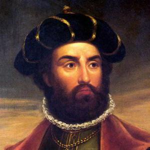
Discovery of America by Christopher Columbus

Christopher Columbus (1451-1506) - Spanish navigator of Italian origin, discovered the American continent in 1492
Born in Genoa (Italy) in the family of a weaver, Christopher Columbus began to go on ships as a teenager. In 1476, he ended up in Lisbon, the capital of Portugal, where at that time information about all the latest geographical discoveries flocked. Year after year, the young Italian went to sea on various ships, visited England, Ireland, the Azores ... From books, his own impressions, conversations with experienced sailors, Columbus collected information and became more and more imbued with the idea that eventually became his true passion : to reach India by going not to the east, but to the west.
By the middle of the 15th century, Europeans already possessed not only knowledge, but also tools, without which ocean travel would not have been possible: they used an astrolabe, a compass, a caravel. Columbus's dream was feasible, and the matter remained small - money was required for long-distance voyage.
Columbus tried to find a patron and patron of the Portuguese court, but was refused. In 1485, the navigator left Portugal and went to the court of the "competitive" maritime power - Spain.
These two kingdoms truly reigned over the seas of that era. Their caravans plied the waters in search of new lands, in pursuit of gold, silver and spices, which were valued above precious metals. The shortest sea route to India was needed by both the Portuguese and the Spaniards. And Columbus, though not immediately, was received at the court of Their Catholic Majesties, King Ferdinand and Queen Isabella.
The anticipation and eloquence of Christopher Columbus were rewarded. Under an agreement signed between him and the royal couple of Spain, he received three ships and funding for their equipment. If successful, Columbus was to become an admiral, viceroy and ruler of all open lands.
In early August 1492, the Santa Maria, Pinta and Nina caravels put to sea.
Columbus himself did not even suspect how successful the coincidence of circumstances of his first trip was. On his side were the right latitude - the shortest route across the Atlantic, fair winds, and even a change in course towards the end of the voyage, as demanded by the crew, who was on the verge of rebellion.

Caravel is a sea three-to-four-masted sailing vessel with one deck and high sides and superstructures. It was common in the Mediterranean countries in the XIII-XVII centuries.
On October 13, 1492, Columbus set foot on the first land he discovered.- one of the Bahamas, he named San Salvador. Confident that he had reached the approaches to India, China and Japan, the navigator went further, reaching the islands of Cuba, Hispaniola and Tortuga (the latter was destined to later become a haven for pirates of the entire Caribbean Sea).
There will be many more ups and downs in the life of the great Italian, but it was then, in the autumn of 1492, that he accomplished his greatest deed - he discovered the New World.
“A false step more than once led to the opening of new roads” (L. Cumor)
Henry the Navigator
The name of Christopher Columbus is the first thing that comes to mind when talking about the Great Geographical Discoveries. But it would be fairer to assume that the first to unfurl the sails to the winds of change was the son of the Portuguese king João I - Infante Henry, later nicknamed the Navigator.
Throughout his life, Henry did not take part in any of the expeditions, but equipped them with a great many. The Infante wanted to find a way along the coast of Africa to India. Until the fulfillment of this dream, Henry the Navigator did not live, but thanks to him, Portugal opened the most sinister, shameful and at the same time the most profitable page in its history - the slave trade.
Vasco da Gama and his journey to India

Vasco da Gama (1460/1469 - 1524) - Portuguese navigator of the Age of Discovery. He commanded the first expedition to sail from Europe to India
Dozens of ships and voyages, hundreds of sailors, three rulers who succeeded each other on the throne are associated with the opening of the route to India - and the name of a harsh and cruel navigator, the first European to reach India by sea, went down in history - Vasco da Gama.
In July 1497, his armada of three ships - the San Gabriel, the San Rafael and the Berriu - set off. Severe trials awaited the flotilla: headwinds and currents, the heat of Equatorial Africa, scurvy that struck the crew halfway to the Cape of Good Hope ... But four and a half months later, Vasco da Gama rounded the southern tip of the African continent and turned to the northeast.
Unlike Columbus, the Portuguese really opened the way to India. Yes, there were numerous clashes ahead with the Arabs, who had long and firmly mastered this part of the world, it was still necessary to equip trading posts and establish trade relations with local rulers, but the main thing was done. Portugal became one of the richest and most powerful maritime powers in the world. From May 1498 until the opening of the Suez Canal to shipping in 1869, the main trade routes from Europe to Asia went by sea.
“He who makes a discovery sees what everyone sees, and thinks what no one comes to mind” (A. Szent-Györgyi)
Spain-Portugal rivalry
In the 15th century, Spain and Portugal shared the palm among maritime powers. So that the two powerful crowns would not be at enmity, opening up new territories, in 1452-1456 the Roman popes Nicholas V and Calixtus III assigned Portugal the right to own lands south and east of Cape Bojador, and Spain recognized this right.

Ancient map of Europe ("Big Atlas", or "Blau's Cosmography", 1667)
However, the discoveries of Columbus in 1492 dramatically changed the situation. Since the admiral believed that he had discovered the western route to India, and Portugal laid claim to the Indian lands, to which it went by the eastern route, the two kingdoms now disputed the ownership of each other.
Fortunately, the dangerous dispute was resolved by Pope Alexander VI Borgia, who in May 1493 established a demarcation line separating the Spanish and Portuguese colonies. Castile now belonged to the lands to the west of the "papal meridian", Portugal - to the east, about which the Treaty of Tordesillas was signed on June 7, 1494. This document not only demarcated the spheres of influence of the two powers, but actually secured their possession of the World Ocean, excluding other European countries from this.
Fernand Magellan's round-the-world trip

Ferdinand Magellan (1480-1521) - Portuguese and Spanish navigator, made the first voyage around the world, discovering the strait leading from the Atlantic Ocean to the Pacific
For the next twenty years, Spanish and Portuguese ships tirelessly plied the oceans. It became quite obvious that America was not India, but a new continent. But so far there was almost no income from it, and it seemed to be an annoying hindrance on the western path to the spices and gold of India. Sailors were looking for an opportunity to get around this obstacle.
Therefore, there was nothing surprising in the fact that in 1518 a Portuguese naval sailor turned to the Spanish council for the affairs of the two Indies - he offered to consider a plan for a western route to the Moluccas, where expensive spices were produced. It's funny that a stranger again turned to the Spanish crown, and again because his project was rejected by the Portuguese monarch. And again, as in the case of Columbus, Spain did not lose by agreeing to finance the expedition.
An experienced sailor undertook to find a strait that would allow sailing to Asia without going around the huge American continent either from the north or from the south.
“Everyone knows from childhood that this and that is impossible. But there is always an ignoramus who does not know this. It is he who makes the discovery ”(A. Einstein)
Magellan's journey was one of the most difficult in the history of that time. It lasted over three years. Of the five ships that went on the expedition, only one returned to the Spanish port, out of two hundred and sixty-five people only eighteen returned. Ferdinand Magellan himself died in a skirmish with the natives on one of the Philippine Islands, having already found the famous strait, which would later be named after him, and being on his way back to Europe.
It is impossible to overestimate the importance of the first circumnavigation of the world. Long-standing disputes about the shape of the planet, the unity of the World Ocean and the predominance of water over land were finally resolved, which had been disputed as far back as the Middle Ages.
Discovery of Australia
France, England, Holland and other countries, which also had serious maritime traditions, could do little to oppose the dominance of the Spaniards and the Portuguese in the Atlantic, India, Central and South America. The British and French began to explore the North American continent, where New England and Canada would subsequently be founded, which would go to the French.

The study of the Pacific began long before the advent of writing. However, for the first time it was opened to the eyes of the European Vasco Nunez de Balboa in 1513. The Spanish conquistador saw him from the mountain range of the Isthmus of Panama
But the most interesting discovery was to be made by the Dutch. Since the time of Aristotle, there has been an idea in the geographical world that in the Southern Hemisphere there must certainly be a large continent that would balance the vast land of the Northern Hemisphere. But for a very long time, ships entered this part of the Pacific more by chance: the “roaring” forties, the “whistling” fifties and the “furious” sixties were avoided by everyone. But over and over again, sailors brought information about various parts of the land, which eventually became known as Terra Australis Incognita - the Unknown Southern Land, although they were mainly islands of various archipelagos of the Pacific Ocean.
And only in 1605 the Dutchman Willem Janszon who led the fleet of the East India Company, first reached the coast of Australia. Almost forty years later, another Dutchman, Abel Tasman, reached New Zealand, Van Diemen's Land (now Tasmania) and marked the island of Fiji on the map. The search for the mysterious Southern Land is over.
“Sometimes it’s more useful not to know what has been done before you, so as not to go astray on the beaten path leading to a dead end” (B. Gersh)
Development of Russian lands
While world powers were mastering the ocean, Russian pioneers were mastering one sixth of the land - the vast expanses of the Russian state.
After the conquest of the Kazan and Astrakhan khanates, the way to the Volga region and the Urals was opened. The colossal sparsely populated expanses could become a source of wealth, but they could also ruin travelers who dared to invade the unknown.
The privileges and vast territories granted by Ivan the Terrible to the merchants Stroganov marked the beginning of the settlement of the Urals and the development there, first of trade, and then of industry - mining of ores, furs and salt.
In 1577, the Cossack detachments of the ataman moved to the east. Yermak, called by the Stroganovs to protect against the Siberian Khan. In 1582, the Siberian Khanate was conquered and annexed to the Russian state.

V. I. Surikov "Conquest of Siberia by Ermak Timofeevich" (1891-1895)
The 17th century was marked by many geographical discoveries: the mouth of the Yenisei was reached, the highlands of Taimyr were mastered, the great Siberian rivers Lena, Yana, Olenyok were mapped.
And now the names known to everyone follow: Ivan Moskvitin, Semyon Dezhnev, Erofei Khabarov, Vladimir Atlasov. Step by step they they discover and develop for their descendants Kolyma and Chukotka, Anadyr and Amur, Kamchatka and the Kuriles ...
Without the Russian pioneers, the map of the world would be completely different. Our compatriots - travelers and navigators - have made discoveries that have enriched world science. About the eight most notable - in our material.
Bellingshausen's first Antarctic expedition

In 1819, the navigator, captain of the 2nd rank, Thaddeus Bellingshausen led the first Antarctic expedition around the world. The purpose of the voyage was to explore the waters of the Pacific, Atlantic and Indian oceans, as well as to prove or disprove the existence of the sixth continent - Antarctica. Having equipped two sloops - "Mirny" and "Vostok" (under the command), Bellingshausen's detachment went to sea.
The expedition lasted 751 days and wrote many bright pages in the history of geographical discoveries. The main one - - was made on January 28, 1820.
By the way, attempts to open the white mainland were made earlier, but did not bring the desired success: there was not enough luck, or maybe Russian perseverance.
So, the navigator James Cook, summing up his second circumnavigation, wrote: “I went around the ocean of the southern hemisphere in high latitudes and rejected the possibility of the existence of the mainland, which, if it can be found, is only near the pole in places inaccessible to navigation.”
During Bellingshausen's Antarctic expedition, more than 20 islands were discovered and mapped, sketches of Antarctic species and animals living on it were made, and the navigator himself went down in history as a great discoverer.
“The name of Bellingshausen can be directly put on a par with the names of Columbus and Magellan, with the names of those people who did not retreat before the difficulties and imaginary impossibilities created by their predecessors, with the names of people who went their own way, and therefore were the destroyers of barriers to discoveries, by which epochs are designated, ”wrote the German geographer August Petermann.
Discoveries of Semenov Tien-Shansky

Central Asia at the beginning of the 19th century was one of the least explored areas of the globe. An indisputable contribution to the study of the "unknown land" - as geographers called Central Asia - was made by Peter Semenov.
In 1856, the main dream of the researcher came true - he went on an expedition to the Tien Shan.
“My work on Asian geography led me to a detailed acquaintance with everything that was known about inner Asia. In particular, the most central of the Asian mountain ranges, the Tien Shan, beckoned me to itself, on which the foot of a European traveler had not yet set foot and which was known only from scarce Chinese sources.
Semenov's research in Central Asia lasted two years. During this time, the sources of the Chu, Syrdarya and Sary-Jaz rivers, the peaks of Khan-Tengri and others were put on the map.
The traveler established the location of the Tien Shan ranges, the height of the snow line in this area and discovered the huge Tien Shan glaciers.
In 1906, by decree of the emperor, for the merits of the discoverer, they began to add a prefix to his surname - Tien Shan.

Asia Przewalski

In the 70s-80s. XIX century Nikolai Przhevalsky led four expeditions to Central Asia. This little explored area has always attracted the researcher, and traveling to Central Asia was his old dream.
Over the years of research, mountain systems have been studied Kun-Lun , the ranges of Northern Tibet, the sources of the Yellow River and the Yangtze, basins Kuku-burrow and Lob-burrow.
Przhevalsky was the second person after Marco Polo to reach lakes-bogs Lob-burrow!
In addition, the traveler discovered dozens of species of plants and animals that are named after him.
“Happy fate made it possible to make a feasible study of the least known and most inaccessible countries of inner Asia,” Nikolai Przhevalsky wrote in his diary.
Around the world Krusenstern

The names of Ivan Kruzenshtern and Yuri Lisyansky became known after the first Russian round-the-world expedition.
For three years, from 1803 to 1806. - this is how long the first circumnavigation of the world lasted - the ships "Nadezhda" and "Neva", having passed through the Atlantic Ocean, rounded Cape Horn, and then reached Kamchatka, the Kuril Islands and Sakhalin by the waters of the Pacific Ocean. The expedition refined the map of the Pacific Ocean, collected information about the nature and inhabitants of Kamchatka and the Kuriles.

During the voyage, Russian sailors crossed the equator for the first time. This event was celebrated, according to tradition, with the participation of Neptune.
A sailor dressed as the ruler of the seas asked Kruzenshtern why he had come here with his ships, because the Russian flag had not been seen in these places before. To which the expedition commander replied: "For the glory of science and our fatherland!"
Expedition of Nevelskoy

Admiral Gennady Nevelskoy is rightfully considered one of the outstanding navigators of the 19th century. In 1849, on the transport ship Baikal, he went on an expedition to the Far East.
The Amur expedition continued until 1855, during which time Nevelskoy made several major discoveries in the area of the lower reaches of the Amur and the northern shores of the Sea of Japan, and annexed vast expanses of the Amur and Primorye to Russia.
Thanks to the navigator, it became known that Sakhalin is an island that is separated by the navigable Tatar Strait, and the mouth of the Amur is accessible for ships to enter from the sea.
In 1850, the Nikolaevsky post was founded by the Nevelsky detachment, which today is known as Nikolaevsk-on-Amur.
“The discoveries made by Nevelsky are invaluable for Russia,” wrote Count Nikolai Muravyov-Amursky , - many previous expeditions to these lands could achieve European fame, but not one of them achieved domestic benefit, at least to the extent that Nevelskoy did it.
North Vilkitsky

The purpose of the hydrographic expedition of the Arctic Ocean in 1910-1915. was the development of the Northern Sea Route. By chance, the captain of the 2nd rank Boris Vilkitsky assumed the duties of the head of navigation. The icebreaking ships Taimyr and Vaygach put to sea.
Vilkitsky moved through the northern waters from east to west, and during the voyage he managed to compile a true description of the northern coast of Eastern Siberia and many islands, received the most important information about currents and climate, and also became the first who made a through voyage from Vladivostok to Arkhangelsk.
The expedition members discovered the Land of Emperor Nicholas I. I., known today as Novaya Zemlya - this discovery is considered the last of the significant ones on the globe.
In addition, thanks to Vilkitsky, the islands of Maly Taimyr, Starokadomsky and Zhokhov were put on the map.
At the end of the expedition, the First World War began. Traveler Roald Amundsen, having learned about the success of Vilkitsky's voyage, could not resist exclaiming to him:
“In peacetime, this expedition would stir up the whole world!”

Kamchatka campaign of Bering and Chirikov

The second quarter of the 18th century was rich in geographical discoveries. All of them were made during the First and Second Kamchatka expeditions, which immortalized the names of Vitus Bering and Alexei Chirikov.
During the First Kamchatka campaign, Bering, the leader of the expedition, and his assistant Chirikov explored and mapped the Pacific coast of Kamchatka and Northeast Asia. They discovered two peninsulas - Kamchatsky and Ozerny, Kamchatsky Bay, Karaginsky Bay, Cross Bay, Providence Bay and St. Lawrence Island, as well as the strait, which today bears the name of Vitus Bering.
Companions - Bering and Chirikov - also led the Second Kamchatka Expedition. The goal of the campaign was to find a route to North America and explore the islands of the Pacific.
In Avacha Bay, the expedition members founded the Petropavlovsk prison - in honor of the ships of the voyage "Saint Peter" and "Saint Pavel" - which was later renamed Petropavlovsk-Kamchatsky.

When the ships set sail for the shores of America, by the will of evil fate, Bering and Chirikov began to act alone - because of the fog, their ships lost each other.
"Saint Peter" under the command of Bering reached the western coast of America.
And on the way back, the expedition members, who had many difficulties, were thrown by a storm onto a small island. Here the life of Vitus Bering ended, and the island on which the expedition members stopped to spend the winter was named after Bering.
"Saint Pavel" Chirikov also reached the shores of America, but for him the voyage ended more safely - on the way back he discovered a number of islands of the Aleutian ridge and safely returned to the Peter and Paul prison.
"Non-Yasak Lands" by Ivan Moskvitin

Little is known about the life of Ivan Moskvitin, but this man nevertheless went down in history, and the reason for this was the new lands he discovered.
In 1639, Moskvitin, leading a detachment of Cossacks, set sail for the Far East. The main goal of the travelers was to "find new unclaimed lands", to collect furs and fish. The Cossacks crossed the rivers Aldan, Maya and Yudoma, discovered the Dzhugdzhur ridge, which separates the rivers of the Lena basin from the rivers flowing into the sea, and along the Ulya river they entered the Lamskoye, or Sea of Okhotsk. Having explored the coast, the Cossacks opened the Taui Bay and entered the Sakhalin Bay, rounding the Shantar Islands.
One of the Cossacks said that the rivers in the open lands “are sable, there are a lot of animals, and fish, and the fish is big, there is no such thing in Siberia ... there are so many of them - just run a net and you can’t drag it out with fish ... ".
The geographical data collected by Ivan Moskvitin formed the basis of the first map of the Far East.
This term is used in relation to the most important geographical discoveries made by European travelers between the 15th and 17th centuries. Geographical discoveries are the search and discovery of new lands previously unknown to people. These are the reasons that prompted people to make great geographical discoveries, starting from the end of the 15th century.
First, at the end of the 15th and beginning of the 16th centuries, commodity production began to grow rapidly in Europe, which led to an increase in demand for raw materials. But since there was not enough raw material in Europe, it became necessary to import it from other countries.
Secondly, the existing trade routes through the Mediterranean Sea, as well as the Great Silk Road that connected Asia with Europe, became extremely dangerous. Control over these routes passed to the Ottoman Empire (Turkey). The task facing the Europeans of opening new maritime trade routes has become a historical necessity. The modern ships and armament that existed by that time made it possible to fully realize the plan. Of great importance was also the invention of the astrolabe, which began to be used in navigation along with the compass. During this period, the Italian scientist P. Toscanelli, based on the fact that the Earth is round, created a map of the world. On it, the shores of the Asian continent went to the western part of the Atlantic Ocean. P. Toscanelli believed that, having sailed from Europe to the west, one could get to India.
The beginning of the great geographical discoveries.
The initiators of the great geographical discoveries were sea travelers from Portugal and Spain. To implement such a grandiose idea, fearless sailors were needed. One of these travelers was the Genoese Admiral Christopher Columbus (1451-1506). He planned to pave the way to India across the Atlantic Ocean.
Columbus managed to conclude an agreement with the royal family of Spain to equip an expedition to find the shortest sea route to India. The king took upon himself the financial support of the expedition. On August 6, 1492, Columbus went to sea on three caravels, leading the expedition.
Discovery of America.
On October 12, 1492, the Columbus expedition landed on one of the Caribbean islands. Columbus named this island San Salvador (now the territory of the state of the Commonwealth of the Bahamas). Thus, the search for the shortest sea route to India led to the discovery of America. This happened as a result of the mistakes of scientists of the 15th century, in particular Toscanelli, who compiled a map of the world. The fact is that when determining the length of the equator, P. Toscanelli made a mistake in calculating 12 kilometers. Subsequently, scientists called this mistake "the great mistake that led to the great discovery."
However, Columbus himself did not understand that in 1492 he sailed not to India, but to America. He believed that he had arrived in India. Therefore, he called the indigenous population of America Indians. Columbus subsequently equipped expeditions to India (actually to America) four more times. As a result of these expeditions, a lot of new lands were discovered, on which the Spanish flag was raised. These territories became the property of Spain. Columbus was appointed viceroy of these lands. The fact that the new continent is not called Colombia, but America, is associated with the name of the Italian navigator and astronomer Amerigo Vespucci (1454 - 1512). In 1499 - 1501, as part of a Portuguese expedition, he explored the coast of Brazil and came to the conclusion that the lands discovered by Columbus were not India, but a new part of the world. Subsequently, he named the continent named after him the New World. In 1507, the cartographer M. Waldseemüller proposed to name the new part of the world discovered by Columbus in honor of Amerigo Vespucci - America. This name suits everyone. The first globe on which the New World was called "America" was created in Germany, in 1515. Subsequently, on other maps, the lands discovered by Columbus began to be called "America".
subsequent discoveries.
Marine Ferdinand Magellan. the route across the Atlantic Ocean leading to India was opened in 1498. The Portuguese sea traveler Vasco da Gama, who sailed from the coast of Spain. In 1519, another Portuguese, Ferdinand Magellan, who also began his sea voyage from the coast of Spain, rounded the American continent, opened a new sea route to India. This round-the-world trip ended in 1522 and finally proved that the Earth is round and most of it is covered with water. And the JI.B. de Torres discovered Australia in 1605.
Significance of the great geographical discoveries. The great geographical discoveries played an important role in the development of many sciences. Geography, history, ethnography, and oceanology were replenished with new information and conclusions. Thanks to these discoveries, new trade sea routes were laid. The main sea trade routes that ran through the Mediterranean now crossed into the Atlantic Ocean. These factors contributed to the formation of world trade in the future.
Thus, thanks to the Great geographical discoveries, the foundation of a global civilization was laid.
Admiral (from the Arabic “amiralbahr” - “lord of the sea”) is a military rank in the navies.
An astrolabe is an astronomical instrument used to determine geographic latitudes and longitudes, as well as the rising and setting of stars.
Vice-assistant, deputy ex officio.
Discovery is a search, an achievement that introduces fundamental changes in the level of knowledge.
- Hello Lord! Please support the project! It takes money ($) and mountains of enthusiasm every month to maintain the site. 🙁 If our site helped you and you want to support the project 🙂, then you can do this by transferring funds in any of the following ways. By transferring electronic money:
- R819906736816 (wmr) rubles.
- Z177913641953 (wmz) dollars.
- E810620923590 (wme) Euro.
- Payeer Wallet: P34018761
- Qiwi wallet (qiwi): +998935323888
- DonationAlerts: http://www.donationalerts.ru/r/veknoviy
- The help received will be used and directed to the continued development of the resource, Payment for hosting and Domain.
Travel has always attracted people, but before they were not only interesting, but also extremely difficult. The territories were not explored, and, setting off on a journey, everyone became an explorer. Which travelers are the most famous and what exactly did each of them discover?
James Cook
The famous Englishman was one of the best cartographers of the eighteenth century. He was born in the north of England and by the age of thirteen he began to work with his father. But the boy was unable to trade, so he decided to take up navigation. In those days, all the famous travelers of the world went to distant countries on ships. James became interested in maritime affairs and moved up the career ladder so quickly that he was offered to become a captain. He refused and went to the Royal Navy. Already in 1757, the talented Cook began to manage the ship himself. His first achievement was the drawing up of the fairway of the St. Lawrence River. He discovered in himself the talent of a navigator and cartographer. In the 1760s he explored Newfoundland, which attracted the attention of the Royal Society and the Admiralty. He was assigned to travel across the Pacific Ocean, where he reached the shores of New Zealand. In 1770, he did something that other famous travelers had not achieved before - he discovered a new continent. In 1771, Cook returned to England as the famous pioneer of Australia. His last journey was an expedition in search of a passage connecting the Atlantic and Pacific oceans. Today, even schoolchildren know the sad fate of Cook, who was killed by cannibal natives.
Christopher Columbus
Famous travelers and their discoveries have always had a significant impact on the course of history, but few have been as famous as this man. Columbus became a national hero of Spain, decisively expanding the map of the country. Christopher was born in 1451. The boy quickly achieved success because he was diligent and studied well. Already at the age of 14 he went to sea. In 1479, he met his love and began life in Portugal, but after the tragic death of his wife, he went with his son to Spain. Having received the support of the Spanish king, he went on an expedition, the purpose of which was to find a way to Asia. Three ships sailed from the coast of Spain to the west. In October 1492 they reached the Bahamas. This is how America was discovered. Christopher mistakenly decided to call the locals Indians, believing that he had reached India. His report changed history: two new continents and many islands, discovered by Columbus, became the main travel destination of the colonialists in the next few centuries.

Vasco da Gama
Portugal's most famous traveler was born in Sines on September 29, 1460. From a young age, he worked in the Navy and became famous as a confident and fearless captain. In 1495, King Manuel came to power in Portugal, who dreamed of developing trade with India. For this, a sea route was needed, in search of which Vasco da Gama had to go. There were also more famous sailors and travelers in the country, but for some reason the king chose him. In 1497, four ships sailed south, rounded and sailed to Mozambique. I had to stay there for a month - half of the team had scurvy by that time. After a break, Vasco da Gama reached Calcutta. In India, he established trade relations for three months, and a year later he returned to Portugal, where he became a national hero. The opening of the sea route, which made it possible to get to Calcutta past the east coast of Africa, was his main achievement.
Nikolay Miklukho-Maclay
Famous Russian travelers also made many important discoveries. For example, the same Nikolai Mikhlukho-Maclay, who was born in 1864 in the Novgorod province. He could not graduate from St. Petersburg University, as he was expelled for participating in student demonstrations. To continue his education, Nikolai went to Germany, where he met Haeckel, a naturalist who invited Miklouho-Maclay to his scientific expedition. So the world of wanderings opened up for him. His whole life was devoted to travel and scientific work. Nikolai lived in Sicily, in Australia, studied New Guinea, implementing the project of the Russian Geographical Society, visited Indonesia, the Philippines, the Malay Peninsula and Oceania. In 1886, the naturalist returned to Russia and proposed to the emperor to establish a Russian colony across the ocean. But the project with New Guinea did not receive royal support, and Miklouho-Maclay fell seriously ill and soon died, without completing his work on a travel book.

Ferdinand Magellan
Many famous navigators and travelers lived in the era of the Great Magellan is no exception. In 1480 he was born in Portugal, in the city of Sabrosa. Having gone to serve at court (at that time he was only 12 years old), he learned about the confrontation between his native country and Spain, about traveling to the East Indies and trade routes. So he first became interested in the sea. In 1505, Fernand got on a ship. Seven years after that, he plied the sea, participated in expeditions to India and Africa. In 1513, Magellan went to Morocco, where he was wounded in battle. But this did not curb the craving for travel - he planned an expedition for spices. The king rejected his request, and Magellan went to Spain, where he received all the necessary support. Thus began his world tour. Fernand thought that from the west the route to India might be shorter. He crossed the Atlantic Ocean, reached South America and discovered the strait, which would later be named after him. became the first European to see the Pacific Ocean. On it, he reached the Philippines and almost reached the goal - the Moluccas, but died in battle with local tribes, wounded by a poisonous arrow. However, his journey opened up a new ocean for Europe and the realization that the planet is much larger than scientists had previously thought.

Roald Amundsen
The Norwegian was born at the very end of an era in which many famous travelers became famous. Amundsen was the last of the navigators who tried to find undiscovered lands. From childhood, he was distinguished by perseverance and self-confidence, which allowed him to conquer the South Geographic Pole. The beginning of the journey is connected with 1893, when the boy left the university and got a job as a sailor. In 1896 he became a navigator, and the following year he went on his first expedition to Antarctica. The ship was lost in the ice, the crew suffered from scurvy, but Amundsen did not give up. He took command, cured the people, remembering his medical background, and brought the ship back to Europe. After becoming a captain, in 1903 he went in search of the Northwest Passage off Canada. Famous travelers before him had never done anything like this - in two years the team covered the path from the east of the American mainland to its west. Amundsen became known to the whole world. The next expedition was a two-month trip to the South Plus, and the last venture was the search for Nobile, during which he went missing.

David Livingston
Many famous travelers are connected with seafaring. he became a land explorer, namely the African continent. The famous Scot was born in March 1813. At the age of 20, he decided to become a missionary, met Robert Moffett and wished to go to African villages. In 1841, he came to Kuruman, where he taught local people how to farm, served as a doctor, and taught literacy. There he learned the Bechuan language, which helped him in his travels in Africa. Livingston studied in detail the life and customs of the locals, wrote several books about them and went on an expedition in search of the sources of the Nile, in which he fell ill and died of a fever.
Amerigo Vespucci
The most famous travelers in the world were most often from Spain or Portugal. Amerigo Vespucci was born in Italy and became one of the famous Florentines. He received a good education and trained as a financier. From 1490 he worked in Seville, in the Medici trade mission. His life was connected with sea travel, for example, he sponsored the second expedition of Columbus. Christopher inspired him with the idea of trying himself as a traveler, and already in 1499 Vespucci went to Suriname. The purpose of the voyage was to study the coastline. There he opened a settlement called Venezuela - little Venice. In 1500 he returned home with 200 slaves. In 1501 and 1503 Amerigo repeated his travels, acting not only as a navigator, but also as a cartographer. He discovered the bay of Rio de Janeiro, the name of which he gave himself. Since 1505, he served the king of Castile and did not participate in campaigns, only equipped other people's expeditions.

Francis Drake
Many famous travelers and their discoveries have benefited mankind. But among them there are those who left behind a bad memory, since their names were associated with rather cruel events. An English Protestant, who had sailed on a ship from the age of twelve, was no exception. He captured local residents in the Caribbean, selling them into slavery to the Spaniards, attacked ships and fought with Catholics. Perhaps no one could equal Drake in terms of the number of captured foreign ships. His campaigns were sponsored by the Queen of England. In 1577 he went to South America to defeat the Spanish settlements. During the journey, he found Tierra del Fuego and the strait, which was later named after him. Rounding Argentina, Drake plundered the port of Valparaiso and two Spanish ships. When he reached California, he met the natives, who presented the British with gifts of tobacco and bird feathers. Drake crossed the Indian Ocean and returned to Plymouth, becoming the first British citizen to circumnavigate the world. He was admitted to the House of Commons and awarded the title of Sir. In 1595 he died in the last campaign in the Caribbean.
Afanasy Nikitin
Few famous travelers in Russia have achieved the same heights as this native of Tver. Afanasy Nikitin became the first European to visit India. He made a trip to the Portuguese colonizers and wrote "Journey Beyond the Three Seas" - the most valuable literary and historical monument. The success of the expedition was ensured by the merchant's career: Athanasius knew several languages and knew how to negotiate with people. On his journey, he visited Baku, lived in Persia for about two years and reached India by ship. After visiting several cities in an exotic country, he went to Parvat, where he stayed for a year and a half. After the province of Raichur, he headed to Russia, paving the route through the Arabian and Somali Peninsulas. However, Afanasy Nikitin never made it home, because he fell ill and died near Smolensk, but his notes survived and provided the merchant with world fame.


