Nauru is an island that died from its own greed. School Encyclopedia
The content of the article
NAURU, The Republic of Nauru, a state on the island of the same name in the southwestern part of the Pacific Ocean (0 ° 30º S and 166 ° 55º E). Nauru Island is a coral atoll confined to the top of a volcanic cone. The island is 5.6 km long and 4 km wide. Coastline length approx. 19 km. The highest point is 65 m above sea level.
Nature.
The hilly limestone plateau, located in the central part of the island, slopes down to the coast in ledges and is covered with a thick layer of phosphorites. A strip of sandy terraces and beaches from 100 to 300 m wide stretches along the perimeter of the island. The island is bordered by a narrow barrier reef that separates the shallow lagoon from the deep water area.
The climate of Nauru is equatorial, hot and humid. Average monthly temperatures approx. 28 ° C. The average annual rainfall is 2000 mm. There are dry years, and in some years up to 4500 mm of precipitation falls. The wettest season lasts from November to February, when the western monsoons prevail.
There are no rivers on Nauru. In the southwestern part of the island there is a small freshwater lake, Buada, which is fed by seeping rainwater. Drinking water is obtained from a single desalination plant and imported from Australia. For domestic needs, rainwater flowing from the roofs is collected in containers.
The soils are porous sandy loam, on which coconut palms, pandanuses, ficuses, laurel (calophyllum) and other deciduous trees grow. Various types of shrub formations are also common. The most dense vegetation is confined to the coastal strip and the vicinity of the lake. Buada. The recultivated quarry dumps are planted with bushes.
The fauna of Nauru is poor. From mammals, rats are found, from reptiles - lizards. The avifauna is more diverse (waders, terns, petrels, frigatebirds, pigeons, etc.). Lots of insects.
Population.
According to an estimate in 2004, the island was inhabited by 12.8 thousand people. Of these, 58% are Nauruans, who are part of the Polynesian group of peoples, 26% are from other islands of Oceania, 8% are Chinese and Europeans each. The birth rate is estimated at 25.61 per 1000 inhabitants, the death rate is 6.95 per 1000, and the natural population growth is 1.87%. Infant mortality in 2004 was estimated at 10.14 per 1000 births. In the composition of the population, the age group under 14 years old is 38.2%, from 15 to 64 years old - 60%, over 65 years old - 1.9%.
As of July 2011, the population was estimated at 9,378.
33% of the population are children and adolescents under 14 years old, people over 65 years old - 1.6% of the population.
The average age of Nauruans is 24.2 years. Population growth rate 0.608%.
countries compared to the world: 143
The birth rate is estimated at 27 births per 1000 population, the death rate is
5.97 deaths per 1,000 population (July 2011 est.).
Infant mortality has fallen to 8.51 deaths per 1,000 babies.
Life expectancy is 65.7 years.
The official languages are Nauruan and English. Among believers, more than 60% are Protestants, the rest are Catholics.
There is no official capital and cities on the island. The seat of government is located in the Meneng district, while government offices and parliament are located in the Yaren district.
State device.
According to the constitution adopted in 1968, the president (head of state and government) is elected by the parliament from among its members for a term of three years. Legislature- Parliament consists of 18 deputies who are elected by popular vote for a three-year term. Executive power is exercised by the government, which consists of 5 or 6 ministers and is accountable to parliament. All Nauruans over the age of 20 have the right to vote. The highest court is the Supreme Court.
Economy.
The main source of income in Nauru is the export of high quality phosphate rock. Thanks to this, the GDP per person until 2005 was 13 thousand dollars. Approx. 2 million tons of phosphorites, and their reserves are rapidly depleted.
In 2005, an Australian mining company entered into an agreement to exploit the remaining phosphate reserves. In 2006, open pit mining of phosphorites was completed, but in 2006, mining began from deeper layers. These reserves will be depleted in 30 years. With the prospect of depleting the phosphate rock deposit, a significant amount of the proceeds from the sale of phosphate rock have been invested in trust funds that should secure Nauru's economic future and ease the transition to a different way of doing business. To cut costs, the government froze salaries and reduced the number of civil servants. Nauru lost additional income in 2008 due to the closure of the Australian refugee center seeking to enter Australia.
A significant part of the country's income in recent years has been Australian aid. Content on site
Statistics on the economy of Nauru, in particular GDP estimates, vary widely.
In 2005, GDP per capita is estimated at $5,000.
Coconut trees are grown on the island. Developed fishing. The economy largely depends on the influx of labor from outside, mainly from the neighboring island states of Kiribati and Tuvalu.
Food, fuel, machinery and equipment, building materials, and consumer goods are imported into the country. The export value of phosphorites is four times the amount of imports.
The main foreign trade partners are Australia, New Zealand, Japan, UK.
Nauru has a 3.9 km railway linking the phosphorite mining area in the center of the island with a port on the southwest coast. A 19 km long highway has been laid along the coast. There is an airport.
Story.
Nauru was discovered in 1798 by the American navigator John Fearn. At that time, at least 12 tribal groups lived on the island. In 1888, Nauru was annexed by Germany and included in the New Guinea protectorate. In 1906, the Australian Pacific Phosphate Company received permission to develop phosphorites. During the First World War in 1914, Nauru was occupied by Australia. In 1919, in accordance with the mandate of the League of Nations, Nauru was transferred to the joint administration of Australia, New Zealand and Great Britain, but Australia carried out the administration. These countries have created a joint company "British Phosphate Commission" for the development of phosphorite deposits, which until the Second World War led their intensive development.
Japan occupied the island between 1942 and 1945, and Australian rule was restored after the war. In 1947, Nauru became a UN Trust Territory and was transferred to the administration of Great Britain, the Commonwealth of Australia and New Zealand. In 1927, a Council of Leaders elected by the people was created, which was endowed with only limited deliberative powers. In the 1940s and 1950s, an independence movement took shape on the island. In 1951, the Council of Leaders was transformed into the Nauruan Council of Local Government, an advisory body to the colonial administration. By 1966, it was possible to achieve the creation of local Legislative and Executive Councils, which ensured internal self-government in Nauru. On January 31, 1968, the independence of the Republic of Nauru was proclaimed. In the same year, the republic became an associate member of the British Commonwealth of Nations. Hammer DeRoburt became president after independence, a position he held until 1989, with the exception of a brief period in 1986-1987, when Kennon Adang came to power. In August 1989, after a period of political instability and a vote of no confidence, DeRoburt was forced to resign. Bernard Doviyogo was elected President the same year and was re-elected in 1992. After the April 1999 elections, René Harris became President. After the elections held in April 2000, Doviyogo was re-elected president, Rene Harris resigned. However, Harris returned to the post in March 2001.
Nauru in the 21st century
After the decision of the Nauru authorities to accept, at the request of the Australian government, over 1,200 illegal refugees from Afghanistan and the countries of the Middle East in exchange for financial assistance (annual $ 10.6 million), protests began in the country. As a result, Parliament passed a vote of no confidence in President Rene Harris and his government. Harris was stripped of power and replaced by the country's former president, veteran politician Bernard Dowiyogo. Harris, however, declared that the vote was invalid and was reinstated by the Supreme Court, but resigned shortly after the decision was made. Dowiyogo re-assumed the presidency, but died two months later, in March. Parliamentary presidential elections were held in May 2003 and were won by Ludwig Derangadage Scotty. He was elected with 10 votes in Parliament. Scotty was elected president of the country twice more - in June 2004, after the dissolution of Parliament and the introduction of a state of emergency in the country, and in August 2007. However, after allegations of financial irregularities against his deputy, Scotty was passed a vote of no confidence in December 2007. he was replaced by Mark Stephen.
In November 2011, Sprent Jared Dabvido was elected as the new president.
Since May 1, 1999, Nauru has been a full member of the Commonwealth of Nations, and since September 1999, the United Nations. Nauru is a member of the South Pacific Commission and the South Pacific Forum.
Anticipating the closure of the only source of foreign exchange earnings in the near future, the government invests a significant part of export earnings in real estate abroad and special accumulation funds.
Nauru is one of several island nations threatened by potential sea level rise as a result of global warming.
Useful data for tourists about Nauru, cities and resorts of the country. As well as information about the population, currency of Nauru, cuisine, features of visa and customs restrictions of Nauru.
Geography of Nauru
The Republic of Nauru is a dwarf state on the coral island of the same name in the western Pacific Ocean. Nauru is the smallest independent republic on Earth, the smallest island state, the smallest state outside of Europe and the only republic in the world without an official capital.
Nauru Island is a raised coral atoll confined to the top of a volcanic cone. The island has an oval shape, from the east the coast is concave - there is the Gulf of Anibar. The surface of the island is a narrow coastal plain 100-300 m wide, surrounding a limestone plateau, which reaches a height of 30 m in the central part of Nauru.
State
State structure
Nauru is a parliamentary republic. The head of state is the president. Legislative body - Parliament of 18 deputies. Executive power is exercised by the government, which consists of 5 or 6 ministers and is accountable to parliament. The state is a member of the Commonwealth of Nations.
Language
Official language: Nauruan, English
Religion
Among believers, more than 60% are Protestants, the rest are Catholics.
Currency
International name: AUD
The Australian dollar is equal to 100 cents. In circulation are banknotes in denominations of 100, 50, 20, 10 and 5 dollars, as well as coins of 1 and 2 dollars, 50, 20, 10 and 5 cents.
You can exchange currency in banks or in any of the hotels on the island. Credit cards are accepted almost everywhere, but there are no ATMs on the island. Traveler's checks can be cashed at banks and hotels.
Nauru Tourism
Holidays in Nauru at the best price
Search and compare prices for all the world's leading booking systems. Find the best price for yourself and save up to 80% on the cost of travel services!
Popular hotels
Tips
Tipping is not accepted and not particularly encouraged.
Office Hours
Bank of Nauru branches are usually open from Monday to Thursday, from 09.00 to 15.00, on Fridays - from 09.00 to 16.30.
Purchases
Since the end of the 20th century, Nauru has positioned itself as an offshore center, so there is no sales tax, but a number of goods are subject to customs duties, the rules for which are periodically changed. Tobacco products and alcohol are not taxed.
The usual opening hours of commercial establishments are from Monday to Friday, from 09.00 to 17.00, on Saturdays from 09.00 to 13.00, however, many private shops operate on their own schedule.
Medicine
Safety
The waters around the islands are home to several varieties of sharks and many poisonous sea creatures.
Emergency Phones
Each region has its own emergency telephone numbers.
The island of Nauru was most likely colonized by Polynesians and Micronesians about 3,000 years ago. The first settlers on the island of Nauru were the inhabitants of the Bismarck Islands.
For Europeans, the island of Nauru was discovered on November 8, 1798 by the British captain John Fearn during his voyage to China from New Zealand. The discoverer then gave the island the name "Pleasant" (English version - Pleasant Island), which was used on English-language maps for the next century.
During the discovery of the island by Europeans, the aboriginal population of Nauru actually lived under a primitive communal system, was engaged in fishing and cultivation of coconut palms and pandanus.
In the middle of the 19th century, the first Europeans appeared on Nauru, who brought to the island both incurable diseases and internecine conflicts, which significantly reduced the number of aboriginal population.
On April 16, 1888, Germany announced the annexation of the island of Nauru and its inclusion in the protectorate of the Marshall Islands, which was then under the control of the Jaluit Company.
At the beginning of the 20th century, large deposits of phosphorites were discovered on Nauru. In 1906, the Australian company "Pacific Phosphate Company" (Pacific Phosphate Company) began to develop these resources, having previously received permission from the German authorities.
After the outbreak of the First World War in Europe, on August 17, 1914, Australian troops captured the island of Nauru, ahead of the Japanese.
As a result of the First World War in 1923, the mandate of the League of Nations gave the island of Nauru under the joint administration of Australia, New Zealand and Great Britain, however, the administrative control still remained with Australia. The countries that received a Nauru mandate established a joint corporation, the British Phosphate Company, which was engaged in the extraction and sale of phosphorites until the beginning of World War II.
In early December 1940, two German auxiliary cruisers "Orion" and "Komet", having passed with the help of Soviet icebreakers along the Northern sea route, attacked Allied merchant ships near the island of Nauru, most of which were sunk. On December 27, 1940, the cruiser Komet, which returned to Nauru, destroyed the port facilities of the island and piles of mined phosphorites.
On August 25, 1942, Japan captured Nauru, while the island was liberated only on September 13, 1945 after the Japanese surrender in World War II. During the occupation of the island by Japan, more than 1,200 local residents were taken to the Chuuk Islands (at that time - Truk), where many of them died, and the rest returned to their homeland only at the beginning of 1946.
After the end of World War II, Australia, New Zealand and the United Kingdom continued to administer Nauru, while continuing to mine phosphate rock.
In the early 50s of the last century, a movement for the national independence of the island was formed on the island.
Currently, the Republic of Nauru is a developing state that builds its economy on the extraction of phosphorites and tourism.
Origin and geography of the island
In origin, Nauru is a coral island. Many experts in a number of printed sources call Nauru a raised atoll. According to scientists, the formation of the island began in the Pliocene, when corals formed a reef on the skeleton of an eroded volcano cone and began to initially form the outlines of the island. Nauru originally had an inland lagoon, traces of which can be observed in the central part of the island, which was eventually filled with coral sand and silt.
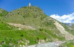
The island of Nauru has an almost regular round shape, somewhat elongated from the southwest to the northeast, with a length of 6 and a width of 4 kilometers. The coastline is quite straight and forms along its length only one small bay of Anibar on the eastern side of the island. The coastline is approximately 18 kilometers long. The relief of the island consists of a narrow coastal plain about 150-300 meters wide, which surrounds a limestone plateau, the height of which reaches 30 meters closer to the central part. Previously, the plateau was covered with a thick layer of phosphorites. The highest point of the island of Nauru is a nameless hill 65 meters high, located on the border of the districts of Buada and Aiwo. In the central part of the island there is a small drying lake Buada. The island is bordered by a narrow coral reef, the width of which ranges from 120 to 300 meters. At low tides Coral reefs rise above the surface of the water with their peaks. Currently, 16 channels have been dug into the reef, which allow small boats to come closer to the coast of the island. At a distance of about 1 kilometer from the coast, the depth of the ocean exceeds 1000 meters due to a sharp cliff.
Climate
The climate on the island of Nauru is classified by experts as monsoonal equatorial, which means that it is almost always hot and humid here. Given the proximity of the equator, there are no temperature fluctuations depending on the season. The average annual temperature is approximately +28 °C, with daytime rates from +27 °C to +35 °C and nighttime temperatures from +22 °C to +28 °C. Sometimes daily figures on the island reach +39-41 °C, then it becomes uncomfortable on the island, especially for visiting tourists. Precipitation on Nauru falls in the form of torrential tropical rains, and their average annual amount is approximately 2000-2500 millimeters. The rainy season on the island falls on the period from early November to mid-February, when the western monsoons blow. In the period from March to the end of October, winds blowing from the northeast dominate here. Sometimes tropical cyclones hit Nauru, which from time to time bring, in addition to showers, also destructive winds.
Population
At the moment, more than 10 thousand inhabitants live on the island of Nauru. In ethnic terms, almost all of them are considered Nauruans (Naurians), the percentage of Fijians, Europeans, Chinese and Tungurans is relatively small. State languages on the island are English and Nauruan, belonging to the Micronesian language group.
Administratively, the island of Nauru is divided into 14 districts. But there are no cities on the island, just as there is no official capital of the Republic of Nauru.
The monetary unit in circulation on the island of Nauru is the Australian dollar (AUD, code 36), consisting of 100 cents.
Flora and fauna
Due to the remoteness of Nauru from the continents, as well as the uncontrolled mining of phosphorites, the flora and fauna of the islands are quite poor. Only 60 species of vascular herbaceous, shrubby and woody plants grow here, among which there are no endemic species. Coconut palms, ficuses, pandanus, laurel trees and other tree species grow almost everywhere on the island. The highest density of vegetation is observed closer to the coastal areas in a strip of about 200-300 meters from the shore and near Lake Buada. In the central regions of Nauru, hibiscus, cherry, almond and mango trees are common.
The fauna of Nauru is even poorer than the flora. All species of mammals now living on the island were introduced earlier by people, and these are cats, dogs, pigs and rats. Of the reptiles on Nauru, lizards are common. Only six species of birds nest on the island (terns, shorebirds, frigatebirds, petrels, pigeons, as well as island emdemics - warblers (Acrocephalus rehsei)).
In the coastal waters of the island there are several species of sharks, sea urchins, mollusks, crabs, as well as a large number of marine poisonous animals.
Tourism
You can arrive on the island of Nauru both by sea and by air. Since 1982, an international airport has been operating on an island off the coast in Yaren County, receiving flights from the Solomon and Marshall Islands, Australia and New Zealand, as well as from the Republic of Kiribati. By sea the island can be reached mainly by small yachts and ships due to the danger of the coral reefs surrounding the island. Tourists arriving on Nauru are accommodated either in the only Menen Hotel on the island, or in numerous private bungalows located off the coast. Tourists go to Nauru, first of all, for the sake of a beach holiday. Tourist infrastructure almost completely absent here, which attracts extreme sportsmen here. Most of the beaches on the island are located in its southern and southwestern parts. At the service of tourists there are two relatively large beaches with stunning white and pink coral sands, washed by clear azure coastal ocean water.
Republic of Nauru- a dwarf state on the coral island of the same name in the western part of the Pacific Ocean with an area of \u200b\u200b21.3 km² and a population of 14 thousand people. Independence was proclaimed in 1968.
Nauru is located 42 km south of the equator. nearest island Banaba is located 306 km to the east and belongs to the Republic of Kiribati. Nauru is the smallest independent republic on Earth, the smallest island nation, the smallest nation outside of Europe, and the only republic in the world without an official capital.
The state is a member of the Commonwealth of Nations. On September 14, 1999, the Republic of Nauru was admitted to the UN. Nauru is a member of the South Pacific Commission and the Pacific Islands Forum. Diplomatic relations between Nauru and the USSR were established on December 30, 1987. Currently, the Russian Ambassador to the Commonwealth of Australia concurrently is the Ambassador to the Republic of Nauru.
Name
The origin of the word "Nauru" is not exactly known. As now, the Nauruans in the distant past called the island "Naoero". The German professor Paul Hambruch, who visited the island in 1909-1910, gave the following explanation of the etymology of this word: according to him, "Naoero" is an abbreviation of the phrase "a-nuau-a-a-ororo" (in the modern spelling "A nuaw ea arourõ") , which translates from the Nauruan language as "I'm going to the seashore." However, the German Catholic missionary Alois Kaiser, who lived on the island of Nauru for more than 30 years and intensively studied the Nauruan language, did not recognize this interpretation, since in the local language, after the word "seashore" used with the verb of motion, the demonstrative word "rodu" should follow, which translates as "down". The Nauruans themselves understand the word "seashore" as the deepest, low-lying place of the island. It is used both in relation to land and to the sea. The very fact that Hambruch does not take into account the word "rodu" in explaining the etymology of the word "Naoero" suggests that his assumptions are unfounded.
The island has other names: the English colonists until 1888 called Nauru "Pleasant" island (eng. Pleasant Island). The Germans called it "Nawodo" or "Onawero". Later, the spelling of the word "Nauru" was changed to "Naoero" so that Europeans would correctly pronounce the name of the country.
Physical and geographical characteristics
The island of Nauru lies in the western part of the Pacific Ocean, about 42 km from the equator. The nearest island, Banaba (Oshen), is located 306 km east of Nauru and belongs to the Republic of Kiribati. Area of exclusive economic coastal zone(EEZ) - 308 thousand 480 km², of which 570 km² are in territorial waters.
Nauru Island is a raised coral atoll confined to the top of a volcanic cone. The island has an oval shape, from the east the coast is concave - there is the Gulf of Anibar. The area of the island is 21.3 km², length - 5.6 km, width - 4 km. The length of the coastline is about 19 km. The highest point - 65 m (according to various sources 61-71 m) - is located on the border of the districts of Aivo and Buada. Approximately at a distance of 1 km from the coast, the depth of the ocean reaches more than 1000 m. This is due to the fact that in this place there is a steep cliff that reaches the ocean floor.
The surface of the island is a narrow coastal plain 100–300 m wide, surrounding a limestone plateau, the height of which in the central part of Nauru reaches 30 m. The plateau was previously covered with a thick layer of phosphorites (nauruite), formed, presumably, from the excrement of seabirds. The island is bordered by a narrow reef (about 120-300 m wide), exposed at low tide and dotted with reef peaks. There are 16 channels dug into the reef, allowing small boats to approach directly the shore of the island.
Geology
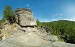
by the most impressive place Nauru is the inner region of the island, where there are huge limestone battlements and pyramids left over from phosphorite mining. The height of these structures in some places exceeds 10 meters, and the quarry itself is a huge labyrinth with many hollows and depressions and resembles a "lunar landscape". In order to facilitate the delivery of mined phosphorites to the port of the island, a narrow-gauge railway was specially built. In the area of limestone blocks, there is practically no soil cover, so all rainwater does not linger on the surface, but seeps through the rock.
Geographers, geomorphologists and geologists carefully studied the relief, soil and geological structure of the island, and from the data obtained they reconstructed in detail the geological history of Nauru. Nauru Atoll has existed since very ancient times. There is still a fringing reef of Tertiary corals. According to geological studies, in the Paleogene, the surface of the bottom of the modern lagoon of the island was 60 m below the current level of the World Ocean (that is, almost the entire island was flooded with water). During the Miocene of the Neogene era, the atoll was significantly uplifted: the bottom of the modern lagoon was 10 m higher than the current level of the World Ocean. Presumably at the same time, the island of Nauru was subjected to severe erosion, as a result of which changes in the karst relief occurred. Subsequently, the central part of the island was under water, resulting in a shallow lagoon in the center of the atoll. Sediments of various deposits rich in phosphorus accumulated in numerous depressions and hollow spaces between the reef limestone. The flooding of the island lasted for a rather long period, so during this time the sediments in the lagoon underwent significant changes: the available phosphorus compounds were enriched.
This was followed by a long period of land uplift of Nauru. The surface of the lagoon was free of water, and plants began to appear on the atoll. At present, the interior of Nauru rises 20-30 m above the ocean surface. Only one depression, the Buada lagoon, has survived on the island, which is completely isolated from ocean waters.
Lifeless "lunar landscape" in the area of worked-out phosphorite quarries. Limestone blocks not overgrown with grass, having a height of up to 15 m, are clearly visible.
There are two controversial points in the above picture of geological processes on the island of Nauru. First, the described process of formation of the local relief is called into question. In addition to the hypothesis that the relief was karstized and the reef limestone dissolved in water, there is another point of view. On the coast and in the rocky shallow waters, especially in the eastern part of the island, there are a large number of preserved small stone columns that have been eroded by sea waves for a very long period. It can be imagined how strongly the shallow water areas were subjected to the impact of the ocean during the uplift of the island. This space was not protected, in any case, wide passages were formed in the rounded reef. Further uplift of the surface of Nauru only led to continued erosion, and rainwater smoothed out the stone columns and battlements.
Secondly, the process of formation of phosphorites remains controversial. In the quarries where the so-called Nauruite was mined, it can be seen that the layer of phosphorus deposits has a very complex structure: numerous fragments of various heights are typical. Consequently, the original accumulation of phosphorites, which usually form from the dead mass of plankton, has been subjected to multiple changes under the influence of erosion and change in occurrence.
In the complex and long history of the island, no doubt, there were periods of strong typhoons when the debris was washed out. Similar disastrous changes can still be observed on many Pacific atolls. In any case, it is obvious that a thin layer of soil was constantly washed out on Nauru, while nodules of phosphorites through which rainwater seeped through did not disappear. Gradually, hollow landforms, primarily depressions and crevices of blocks of reef limestone, were filled with gravel and debris.
There is another version of the origin of the phosphorite deposit on the island: in the process of weathering of rocks on the surface, depressions and sharp cones formed, which served as perfect place for nesting birds. Gradually, the island became covered with excrement of seabirds. The resulting guano gradually turned into calcium phosphate. The content of phosphate in the rock of the island exceeds 90%.
Climate
The climate on Nauru is equatorial monsoon, hot and humid. The average temperature is about +27.5 °C. During the daytime, it usually fluctuates between +26 °C and +35 °C, and at night between +22 °C and +28 °C. Daytime temperatures can reach +38-41 °C. The average annual rainfall is 2060 mm. There are dry years, and in some years up to 4500 mm of precipitation falls. Such significant fluctuations are explained by the El Niño phenomenon. The rainy season lasts from November to February, when the western monsoons (cyclone season) predominate. Winds prevail from March to October northeast direction. About 30 million m³ of water falls on the island a year with almost no surface runoff.
The government of Nauru is concerned about the problem of global warming, since if the level of the World Ocean rises, the island is threatened by flooding. Therefore, the republic is trying to attract the attention of the world community, primarily through the UN.
Hydrology and soils
There are no rivers on the island of Nauru. In the southwestern part of the island there is a small, slightly brackish Lake Buada, which is fed by rainwater. Its level is 5 meters higher than the level of the ocean surrounding Nauru.
One of the problems of the island is the lack of fresh water. Against the backdrop of an increase in the population of the country, it is becoming more acute every year. There is only one desalination plant operating on the island, which runs on electricity generated by Nauru's only power plant. However, due to the very high cost of electricity, the desalination plant often stops working. During rains, the population collects water in special containers and then uses it for domestic needs, for watering gardens and for livestock. During the drought, water is brought in by ship from Australia.
In Yaren County, there is a small underground lake, Mokua Vel, connected to the Mokua cave system. Near the coast, on the border of the Iyuv and Anabar districts, there is a cluster of small lagoons, surrounded on all sides by land.
The soil layer on the coast of Nauru is very thin, only 25 centimeters, and consists of more coral debris and gravel than sand. On the central plateau, thin soils are mainly represented on top of limestone blocks, consisting of organic matter and sand or dolomite with a low content of phosphates. The layer of arable land is about 10-30 cm deep and lies on top of reddish-yellow subsoils, the depth of which varies from 25 to 75 cm.
Flora and fauna
Due to the very small size of the island, its isolation from the mainland and large archipelagos Nauru has only 60 native vascular plant species, none of which are endemic. Severe destruction after World War II, monoculture expansion of the coconut palm and mining of phosphorites led to the destruction of the vegetation cover in most of Nauru, which has now been restored to 63% of the territory.
Coconut palms, pandanus, ficus, laurel and other deciduous trees grow everywhere on the island. Various types of shrub formations are also common. The densest vegetation is confined to the coastal strip of the island, about 150-300 m wide, and to the vicinity of Lake Buada. Hibiscus is found in the interior of Nauru, as well as cherry, almond and mango plantings.
The low-lying areas of the island are covered with dense vegetation, represented mainly by low-growing plants, while woody plants predominate in the higher areas.
The fauna of Nauru is poor. All mammals were introduced by people: Polynesian rats, cats, dogs and pigs, as well as chickens. Reptiles are represented by lizards. The avifauna is more diverse - only 6 species (waders, terns, petrels, frigatebirds, pigeons). Only one species of songbird lives on Nauru - it is the warbler (lat. Acrocephalus rehsei), endemic to the island. Lots of insects and other invertebrates. The waters around the island are home to a variety of sharks, sea urchins, shellfish, crabs and many poisonous marine animals.
Administrative divisions of Nauru
The territory of Nauru is divided into 14 administrative districts, which are combined into 8 electoral districts.
Population
According to a July 2007 estimate, the population of the Republic of Nauru was 13,528, including 6,763 men and 6,765 women. Population density - 629 people. per km².
In 1968, at the time of independence, the population was 3,000.
The birth rate in Nauru is estimated at 24.47 per 1000 inhabitants, the death rate is 6.65 per 1000, and the natural population growth is 1.781%. Infant mortality in 2007 was estimated at 9.6 per 1,000 newborns.
The proportion of children under 14 in 2007 was 36.4%, of the adult population from 15 to 64 years old - 61.6%, over 64 years old - 2%. The average life expectancy for men in 2007 was 60 years, for women - 67 years.
There is no official capital and cities on the island. The President's residence is located in the Meneng district, while government offices and parliament are located in the Yaren district. The entire population of the island lives along the coast, as well as around Lake Buada.
Ethnic composition
About 58% of the population of Nauru is the indigenous people of the republic - the Nauruans. Of the total population of Nauru, people from other Pacific Islands (mainly Tuvaluans and Tungarans) make up 26%, Chinese - 8%, Europeans - 8%. The proportion of foreign citizens in the country's population is high.
Based on the language of the Nauruans, it is customary to refer to the Micronesian group of peoples, however, not only Micronesians, but also Polynesians and Melanesians took part in the formation of this ethnic group.
Languages
Nauruans speak the Micronesian language, Nauruan. Until 1968, the Republic of Nauru was jointly owned by Australia, Great Britain and New Zealand, so English, along with Nauruan, is the official language.
The writing of the Nauruan language was created about 100 years ago on the basis of the Latin alphabet and included 17 letters. Subsequently, due to the significant influence of other languages, primarily German, Tok Pisin and Kiribati, the alphabet expanded to 28 letters. A significant contribution to the study of this Micronesian language was made by the Catholic missionary Alois Kaiser, who wrote a textbook on the Nauru language, as well as the American (originally from Germany) Protestant missionary Philip Delaporte.
Religious composition
Today, Nauru is mostly Christian. The majority of Nauruans (57%) are members of Protestant churches, including 44% of the Nauruan Congregational Church, which has its own chapels in Meneng, Buada, Anabar and Nibok districts, as well as the main church in Aiwo district. The remaining 13% are evangelicals.
About 24% of the inhabitants of Nauru are followers catholic church, which has its own chapel in Yaren County, as well as a school in Eva County (Kaiser College). About 5% of the inhabitants profess Buddhism and Taoism, 2% are Bahá'ís. A small group of Nauruans adhere to a traditional belief that includes the worship of the goddess Eijebong and the island spirit Buitani.
The government restricts the activities of some denominations, such as the Modern Church of Jesus Christ (Mormons) and Jehovah's Witnesses (adherents are mainly among foreigners working in the Phosphate Corporation of Nauru). Marshall Islands, he was deported.
In 1995, some of the restrictions were lifted. For example, the citizens of Nauru were given the right to preach from door to door.
Political structure
Nauru is an independent republic. The constitution, adopted on January 29, 1968 (amended on May 17, 1968), establishes a republican form of government with the Westminster system of parliamentarism and some features of a presidential form of government.
Legislature
The supreme body of legislative power is a unicameral parliament, consisting of 18 deputies. The manner in which members of Parliament are elected is determined by the Constitution of Nauru. Elections are popular; Only a citizen of Nauru who has reached the age of 20 can become a deputy. Members of Parliament take an oath upon taking office. The term of office of members of parliament is 3 years. Before the expiration of the term, the powers may be terminated in the event of the dissolution of Parliament by the Speaker after consultation with the President of the country.
At their first meeting, members of parliament elect the speaker of parliament and his deputy, after which they proceed to elect the president of the country from among their members.
executive power
The head of state and government of Nauru is the President. The procedure for electing the President is determined by the Constitution of Nauru. Only a member of parliament can be elected president. The election takes place at a parliamentary session immediately after the parliamentary elections. A presidential candidate is considered elected if he receives a simple majority of votes. The term of office of the president is 3 years, and one person cannot hold the office of president and member of parliament at the same time. Prior to the expiration of the term, powers may be terminated in the event of resignation, persistent inability of the president for health reasons to perform his duties, or removal from office (impeachment). At least half of all deputies of parliament must vote for the dismissal of the president. After the impeachment of the president, presidential elections are called. If the president is not elected within seven days after the decision of the parliament to remove the president from office, the parliament is automatically dissolved.
The President appoints from the Parliament the Cabinet of Ministers, consisting of no more than 6 and no less than 5 ministers (including the president). The Cabinet of Ministers is an executive body that is collectively responsible to the country's parliament. In the manner prescribed by law, the president introduces a state of emergency, decides on pardons, appoints judges of the Supreme Court of Nauru, resident magistrates of district courts (with the consent of the chief judge).
Judicial branch
The judiciary in Nauru is completely independent. Common law operates in the republic - a legal system in which judicial precedent is recognized as the source of law. Under common law and the Adopted Laws Act 1971, part of the Nauruan traditions, practices and institutions constitute the legal system of Nauru.
The Nauruan judicial system includes the Supreme Court, Court of Appeal, District Courts and Family Courts. According to the Nauru Lands Committee Ordinance, there is a land committee in the country that resolves land disputes and has the right to appeal to the Supreme Court of Nauru.
Article 48 of the Constitution of Nauru establishes the Supreme Court of Nauru, consisting of a chief judge and a panel of judges. The Chief Justice, like other judges of the Supreme Court, is appointed by the President of Nauru. Only citizens of the Republic of Nauru who have worked as barristers or solicitors in the country for at least 5 years and whose age does not exceed 65 years become judges of the Supreme Court of Nauru.
In many matters, the highest court is the Supreme Court of Australia.
Constituencies
The territory of the Republic of Nauru is divided into 8 electoral districts. Electoral district The administrative districts that make up the electoral district
All citizens of Nauru over the age of 20 have the right to vote. Participation in the voting is compulsory: in case of not appearing at the polling station on the day of voting, a fine is imposed.
Political parties
There are 3 political parties in Nauru (Democratic Party, Naoero Amo and Center Party). But, as a rule, the majority of deputies of the local parliament is not a member of political parties, being independent.
Armed forces and police
The Republic of Nauru does not have any national armed forces. Under an informal agreement, the security of the island is carried out by Australia. However, 3,000 Nauruans of military age are at the disposal of the republic. Of these, less than 2,000 people are suitable for military service for health reasons.
Internal security is provided by a few national police forces. The most common offenses in Nauru are violations of the speed limit, violations of privacy, public order and bicycle theft.
Foreign policy and international relations
The Republic of Nauru has a special status in the Commonwealth of Nations, of which it became a member in 1968 after independence. From May 1999 to January 2006, Nauru was a full member of this organization. On September 14, 1999, she became the 187th member of the United Nations. Also, this state is a member of the Pacific Islands Forum, the Asian Development Bank (52nd member since September 1991) and other international organizations.
The Republic of Nauru maintains diplomatic relations with many countries of the world, including Russia. Its main partners are Australia, Great Britain, India, New Zealand, USA, Thailand, Taiwan, Philippines, South Korea and Japan.
On December 15-16, 2009, the Republic of Nauru became the fourth country in the world to recognize the independence of Abkhazia and South Ossetia, after Russia, Nicaragua and Venezuela.
Relations with China and Taiwan
On July 21, 2002, the Republic of Nauru severed diplomatic relations with Taiwan, established back in 1980, and established with China. The Nauruan president, at that time, Rene Harris, signed an agreement with China in Hong Kong, according to which the country recognized only one government of China - the government of the PRC. China, on the other hand, committed itself to provide financial assistance to Nauru in the amount of $60 million, as well as to help pay off $77 million of the debt of General Electric.
The reaction of Taiwan followed immediately: the government of the republic, not recognized by most countries of the world, accused the PRC of dollar diplomacy and did not rule out the possibility of demanding from the government of Nauru the payment of a debt in the amount of 12.1 million US dollars, which went to build a hotel in Meneng.
On May 9, 2005, a meeting was held in Majuro between Nauruan President Ludwig Scotty and Taiwanese President Chen Shui-bian. Shortly after, on May 14, diplomatic relations between Nauru and Taiwan were officially resumed, which complicated relations with the PRC. However, diplomatic relations with China were not interrupted, and the PRC still has its representation on the island. Taiwan provides significant assistance to Nauru in agriculture, fishing, and tourism.
Relations with Australia
Nauru maintains a close relationship with Australia, which plays a key role in trade and investment. Australia is represented in the Republic of Nauru by a Consul General, a Vice Consul and two representatives from the Australian Department of Immigration. The Republic of Nauru, in turn, is represented by the Consul General in Melbourne.
In August 1993, the governments of the two countries signed the Compact of Settlement, which ended the litigation of Nauru against Australia in the International Court of Justice over the rehabilitation of lands that were mined for phosphate rock before Nauru's independence. As a result, Australia paid Nauru 57 million Australian dollars and promised to provide another 50 million over 20 years.
Nauru also cooperates with Australia to combat smuggling in the region, with the Australian immigration center located in the Republic of Nauru.
Relations with EU countries
In August 1995, Nauru, like Kiribati, severed diplomatic relations with France after it tested nuclear weapons off the atolls of Moruroa and Fangataufa during French Polynesia. However, on December 15, 1997, diplomatic relations with France were restored after the announcement of the French government to stop nuclear weapons testing in the region. The President of Nauru, Kinza Clodumar, appreciated the significant French assistance to the small nations of the Central and South Pacific.
In general, Nauru maintains friendly relations with European Union. European countries mainly help this Pacific state in the energy sector.
Story
Nauru was settled by Micronesians and Polynesians about 3,000 years ago. According to one version, the first settlers arrived in Nauru from the Bismarck Islands and represented the Proto-Oceanic ethnic group, even before its breakup into Melanesians, Micronesians and Polynesians. Traditionally, the islanders considered their maternal lineage. Before the arrival of Europeans, the population of the island of Nauru consisted of 12 tribes, which is reflected in the twelve-pointed star on the modern flag and coat of arms of the Republic of Nauru. Nauru was the first European to discover on November 8, 1798, sailing from New Zealand to China, English captain John Fearn (English), who gave the island the name "Pleasant" (English Pleasant Island), which was actively used for 90 years. At that time, the decomposition of the primitive communal system was observed on Nauru. The main crops were coconut palm and pandanus. Nauruans fished on the reef, from canoes and with the help of specially trained birds - frigates (lat. Fregata minor). They also managed to acclimatize hanos fish (lat. Chanos chanos) in Lake Buada, providing for themselves additional source food. Fishing was done exclusively by men.
In the 19th century, the first Europeans began to settle on the island. They were runaway convicts, deserters from those approaching the island. whaling ships and later individual merchants. Aliens (Europeans) brought venereal diseases to the island, they soldered the Nauruans, kindled internecine wars, which became incomparably more bloody due to the use of firearms.
Nauru was annexed by Germany in 1888
On April 16, 1888, the island of Nauru was annexed by Germany and incorporated into the protectorate of the Marshall Islands. The population of the island was taxed. But for some time the island continued to live its secluded life. The situation changed after large deposits of phosphorites were discovered here. In 1906, the Australian Pacific Phosphate Company received permission to develop them. This left a deep imprint on the entire subsequent history of Nauru.
On August 17, 1914, the island of Nauru was captured by Australian troops during the First World War. A small military detachment was transferred on a ship owned by the Pacific Phosphate Company. The Australians were only slightly ahead of the Japanese, who were also ordered to occupy the island rich in phosphorites. The Australians pursued several goals. First, it was important to disrupt the German Etappendienst system by capturing the transmitting station on the island, which was part of a network of radio stations providing communication with German ships and vessels. Secondly, the Commonwealth government was wary of Japan's actions, quite rightly suspecting the latter of expansionism. As a result of the war in 1923, Nauru received the status of a mandated territory of the League of Nations and was transferred under the joint administration of Great Britain, Australia and New Zealand, but Australia carried out the administration. These countries bought from a private company all its rights to phosphorite deposits and created a joint company, British Phosphate Commission, to develop phosphorite deposits and sell them. Intensive development of phosphorites was carried out until the Second World War, but only meager compensation was paid to the indigenous people.
In early December 1940, the German auxiliary cruisers Komet and Orion sank one Norwegian and several British merchant ships off Nauru. Some of them were waiting for the loading of phosphorites off the coast of the island. The smoke of the burning phosphorite carrier "Triadika" was visible from the coast of Nauru. The island's radio station received alarms sent by the Komata. The information received was transmitted by radiogram to the headquarters of the Australian Navy (English). The wreckage of sunken ships was thrown by the waves onto the coast of Nauru. Almost all the captured crew members and passengers were landed by the Germans on December 21 on the island of Emirau (English) in the Bismarck archipelago. Some of them were able to quickly reach the city of Kavienga (English) and inform the Australians about the impending attack on the island of Nauru, but Australia did not have warships capable of preventing the raid in the area. On December 27, 1940, the Komet cruiser returned to Nauru to bombard port facilities. Standing abeam the island, the Komet raised the war flag of the Kriegsmarine and sent a radio signal with the order to clear the piers and the oil storage. However, the crowd of curious did not disperse, only a warning shot dispersed the islanders. After shelling, only ruins remained on the site of the port. The resulting fire destroyed a large pile of phosphorites, already purchased by the Japanese.
On August 25, 1942, the island of Nauru was captured by Japan and liberated only on September 13, 1945. During the period of Japanese occupation, 1,200 Nauruans were deported to the Chuuk Islands (then called Truk) in the Caroline Islands, where 463 of them died. In January 1946, the surviving Nauruans returned to their homeland.
Since 1947, Nauru has become a UN Trust Territory, while continuing to be under the joint administration of Great Britain, Australia and New Zealand. In the mid-1970s, up to 2 million tons of phosphate rock were mined and exported annually, worth A$24 million. In 1927, a popularly elected Council of Leaders was created, which was endowed with only limited deliberative powers. In the 1940s and 1950s, an independence movement took shape on the island. In 1951, the Council of Chiefs was transformed into the Nauruan Council of Local Government, an advisory body to the colonial administration. By 1966, it was possible to achieve the creation of local Legislative and Executive Councils, which ensured internal self-government in Nauru. Independence was proclaimed on January 31, 1968.
In the late 1960s and early 1970s, in the American Trust Territory of the Pacific Islands, proposals were made to create a single state on the territory of Micronesia and part of the islands of Polynesia, which was to include Nauru. However, these plans were not destined to come true, and the trust territory itself broke up into four states - the Marshall Islands, Palau, Northern Mariana Islands And Federated States Micronesia.
Current situation and economy
In the 1970s and 1980s, the Republic of Nauru, which had an abundance of phosphorites, belonged to the richest countries in the world in terms of per capita income - 13 thousand US dollars - in the 1970s and 1980s. The gross national product in 1986 was $20,000 per capita. The economy of the island then largely depended on the influx of labor from outside, mainly from neighboring island states - Kiribati and Tuvalu. At that time, the value of exports of phosphorites was four times the amount of imports, and Australia, New Zealand, Japan and the United Kingdom were the main foreign trade partners. Anticipating the closure of the only source of foreign exchange earnings in the near future, the government invested a significant part of export earnings in real estate abroad and special accumulation funds. However, when the mineral reserves were almost exhausted, it turned out that the state did not take enough care of the country's future.
The mining of phosphorites has had a devastating effect on the relief and vegetation cover of the plateau in the central part of the island. By 1989, the territory, which occupies about 75%, was actively developed, and about 90% of the forest that covered the plateau was destroyed (only 200 hectares of vegetation remained). No land reclamation measures were taken, and by the end of the 20th century, up to 80% of the land had turned into a wasteland resembling a “lunar landscape”.
In 1989, the Republic of Nauru filed a lawsuit in international court over the actions of Australia during the administration of the island - and in particular over the severe environmental consequences resulting from the development of phosphate rock. Australia had to pay compensation. The depletion of the mines also led to political instability, from 1989 to 2003 the government changed 17 times in the country.
In the 1990s, the island of Nauru turned into an offshore zone. Several hundred banks were registered there, which in 1998 received deposits from Russia for 70 billion US dollars. Under pressure from the FATF (Intergovernmental Commission on Combating Money Laundering) and under the threat of sanctions from the United States, the Republic of Nauru was forced in 2001 to restrict, and in 2003 to ban the activities of offshore banks and take measures against money laundering.
The Republic of Nauru was engaged in the sale of passports foreign citizens(the so-called “investor passports”), but in recent years this practice has been abandoned.
At the beginning of 2003, an acute political crisis erupted in Nauru. There were two contenders for the role of president at once: Rene Harris and Bernard Doviyogo. During the clashes that broke out, the presidential residence burned down and telephone communications were cut off. Communication with the outside world for several weeks was carried out only when a ship with a satellite phone entered the port.
A significant part of the country's income in recent years has been Australian aid. Keeping refugees on their territory seeking to get to Australia is an important income of the country, sponsored by Australia.
Agriculture
Bananas, pineapples, papaya, mangoes, breadfruit, coconut palms are grown on the coastal strip of the island, which mainly go to the local market.
Fishing
Nauru's fishing industry is still in its infancy, with only two small fishing boats in the country that fish mainly for the domestic market. Part of the tuna caught is exported to Australia and Japan, but incomes are still very low: in 2001, for example, only about 600 kg of tuna per week were exported. In 2000, the first fish market, which also provided part of the country's population with work.
IN Lately a significant source of replenishment of the local budget was the income from the issuance of licenses for the right to catch fish in the Exclusive Economic Zone (EEZ). So, in 2000, the income amounted to about 8.5 million Australian dollars. The main partners in this area are fishing companies from China, South Korea, Taiwan, the USA, South Korea and Japan.
Aquaculture is also developing on Nauru: in small artificial reservoirs hanos fish is bred on the island, mainly going to the domestic market.
Industry
In the 1980s, the extraction of phosphorites decreased significantly (from 1.67 million tons in 1985-1986 to 162 thousand tons in 2001-2002) and was completely stopped in 2003. But thanks to the investment of the Australian phosphate mining company Incitex Pivot, the mining infrastructure was restored, and already in September 2006, the export of phosphate rock resumed. Presumably, the primary reserves of this rock enough until 2009-2010.
Food, fuel, machinery and equipment, building materials, and consumer goods are imported into the country.
Transport
The length of the roads to Nauru is about 40 km. The length of paved roads is 29 km, of which 17 km are located along the coast. From the area of phosphorite mining, a 12-kilometer unpaved road stretches to the coast. Nauru International Airport is located in the south of the island. The national airline of Nauru is Aue Airlines, which operates only one Boeing 737 aircraft.
Nauru has a 3.9 km long railway linking the phosphorite mining area in the center of the island with a port on the southwest coast. Public transport absent, and most families use private vehicles. There is sea communication.
Connection
The first postage stamps were issued on Nauru in 1916. They were UK stamps overprinted with NAURU.
Nauru's only radio station is owned by the government and mainly broadcasts Radio Australia and the BBC. The island also has a government television, Nauru TV.
Nauru has no regular print media. The Nauru Bulletin newspaper (in English and Nauruan), The Visionary (newspaper owned by the opposition Naoero Amo party) is published from time to time. The Central Star News and the Nauru Chronicle are published once every two weeks.
Since September 1998, the Internet has appeared on Nauru, it is provided by CenpacNet. Subscription users are estimated to make up only half of the total Internet audience in Nauru. Back in May 2001, CenpacNet launched several state-of-the-art Internet cafes under its own brand. They provide users with Internet access at a cost of $5 per hour. In addition, in the cafe you can scan documents and process digital photos.
The telecommunication system of the island is well developed. Many public telephones have direct access to the international IDD system, but due to the fact that the service is carried out through the networks of Australian companies, outgoing international calls are made through operators. Recently, there have been regular disruptions in communication, as foreign companies serving this market refuse to provide their services without pre-payment. Cellular communication of the AMPS standard covers almost the entire island. Local networks are not compatible with the GSM standard, therefore, if you need to maintain constant communication, it is recommended to rent local format phones at the offices of mobile operators.
Tourism
Tourism on the island is limited due to environmental pollution left after the mining of phosphorites. Russian citizens need a visa to visit Nauru. A visa can be obtained by applying directly to the Department of Customs and Immigration of Nauru or to the Consulate General of the Republic of Nauru in Melbourne (Australia). A short-stay visitor visa is issued to persons arriving in Nauru for the purpose of tourism, visiting friends or relatives. The holder of a visitor visa may not, without special permission from the Nauru Department of Customs and Immigration, work, take part in religious or educational projects, or engage in any activity related to making a profit. The visa fee for a short stay visitor visa is AUD 100. The fee is payable upon arrival in the country in cash. All passengers leaving the country will be charged an airport tax of AUD 25 payable directly at the airport. Children under the age of 12, crew members, passengers in transit, and persons holding special written permission from the Nauru Ministry of Justice are exempt from paying the fee.
Monetary system and finance
At the beginning of the 21st century, the government of Nauru faced many financial problems, primarily due to a decrease in the export of phosphorites. As a result, in 2002 the country was unable to repay debts to some creditors on time. The government continues to rely on the resources of the Bank of Nauru, which is trying to solve the problem of budget deficits and royalties.
The monetary unit of Nauru is the Australian dollar. The level of inflation on the island is quite high - 4% in 2001 (this is mainly due to an increase in oil prices on the world market and the cost of its transportation). In 2000, the budget deficit amounted to 10 million Australian dollars, or about 18% of the country's GDP. Public debt has increased - in 2000 it amounted to 280 million Australian dollars.
There is no sales tax in Nauru, however, a number of goods are subject to customs duties, the rules of which are changed from time to time. Tobacco products and alcohol are not taxed.
Shop opening hours: Monday to Friday - from 09:00 to 17:00, on Saturdays - from 09:00 to 13:00, but many private shops operate on their own schedule.
culture
There is very little information about the early culture of the island of Nauru: due to the strong influence of the West, many customs and traditions have already been forgotten by the locals. The absence of writing among the ancient Nauruans only complicates the study of the cultural wealth of the country.
The early culture of the Nauruans was based on the culture of the 12 tribes that inhabited the island. There was no common leader on Nauru, and each tribe had its own history. Traditionally, tribes were divided into clans, and each person in it belonged to certain classes: temonibe (naur. Temonibe), emo (naur. Emo), amenengame (naur. Amenengame) and engame (naur. Engame). The two poor classes were called Itsio (Naur. Itsio) and Itiora (Naur. Itiora). The main factor in determining a person's belonging to a particular class was the origin of the mother. A privileged position was occupied by temnibe, who were allowed to engage in fishing and who even owned certain areas on the sea.
Most of the settlements were at that time on the seashore, and only a few were located near Lake Buada. The islanders lived in small "estates" consisting of two or three houses. Most of them united in villages. In total, there were 168 villages on Nauru, united in 14 regions, which currently form the 14 administrative districts of the island.
Every family on Nauru owned a plot, and some even owned fish ponds near Lake Buada. The land was inherited.
Sport
The national sport of Nauru is Australian football. There is also a national football team, but it has not yet been recognized by either FIFA or the Oceania Football Confederation due to the lack of professional players and large stadiums in the country. The color of the players uniform is blue with a yellow transverse stripe. The first game of the national team with a team from another country took place on October 2, 1994. In it, the Nauru team beat the Solomon Islands team with a score of 2: 1. It was a huge win as the Solomon Islands were considered the clear favorites (they won the Melanesia Cup the same year). There are several sports grounds and stadiums on the island: Linkbelt Oval (located in Aiwo County, but it is significantly outdated and does not meet international standards), Meneng Stadium (built in 2006 and seats 3,500 people) and Denig Stadium.
Weightlifting, softball, basketball and tennis are very popular. The government of the country pays the most attention to weightlifting: it is in this discipline that Nauru has achieved the greatest success. After the sensational victory of weightlifter Marcus Stephen at the Commonwealth Games in 1990, the Nauru National Olympic Committee was established in Nauru. In 1992, Marcus became the first Nauruan to take part in Olympic Games held in Barcelona. Nauru was officially accepted into the Olympic Movement in 1996. The first official athletes from Nauru were Marcus Steven, Gerard Garabwan and Quincy Detenamo.
healthcare
As a result of an effective government program to address health problems, which has as its main goals the improvement of the water supply of the population and the implementation of constant sanitary and preventive measures, outbreaks of infectious diseases on the island have been avoided in recent years. However, non-communicable diseases such as diabetes, hypertension, cardiovascular diseases and cancer, as well as respiratory diseases, have become the main causes of death in humans. The population of Nauru suffers greatly from obesity. In 2003, Nauru's adult prevalence of diabetes (30.2%) was the highest in the world.
One of the main problems in Nauruan health care is the problem of personnel, so the government of the country is trying to attract as many specialists as possible to this area. Medical care on the island is free. In July 1999, the Nauru General Hospital and the National Phosphate Corporation Hospital were merged into the Republic of Nauru Hospital, which employs only five doctors. People with serious illnesses are mostly sent to Australia for treatment.
In 1995-1996, spending on health care amounted to 8.9 million Australian dollars, or 8.9% of the country's total budget. Most of the professional doctors are expatriates.
Education
Education in Nauru is compulsory for children from 6 to 15 years old (grades 1-10). The educational system also includes 2 stages for young children: preschool (Eng. Pre-school) and preparatory stage (Eng. Preparatory School).
Primary education is provided during the first 6 years of schooling, i.e. for children aged 6 to 11. The first two years of study are held at Yaren Primary School, the third and fourth at Aiwo Primary School, and from the fifth at Nauru College. At the end of elementary school, exams are taken to obtain a Certificate of Primary Education (Eng. Nauru Primary Certificate).
The next step is secondary school (grades 7-10 are compulsory and grades 11-12 are optional). After grade 10, exams are taken to obtain a Certificate of Secondary Education (eng. Nauru Junior Certificate). In the case of continuing education at the end of grade 12, exams are taken for a Certificate of Secondary Complete Education (eng. Pacific Senior School Certificate).
Residents of the island receive higher education abroad, mainly in Australia. Nauru also has a branch of the University of the South Pacific, which provides distance learning courses.
Education in Nauru is free.
(God's will comes first)"
(Song of Nauru)"

Nauruan, Nauruan, Nauruan,
naurets, naurets
Republic of Nauru- a dwarf state on the coral island of the same name in the Western Pacific Ocean with an area of 21.3 km² and a population of 10,084 people (2011). Independence was proclaimed in 1968.
Nauru is located 42 km south of the equator. The nearest island, Banaba, is located 288 km to the east and belongs to the republic. Nauru is the smallest independent republic on the island, the smallest island state, the smallest state outside and does not have an official capital (the unofficial capital of the country is the city of Yaren, where the country's parliament and airport are located).
The state is a member of the Commonwealth of Nations. On September 14, 1999, the Republic of Nauru was admitted to the UN. Nauru is a member of the South Pacific Commission and the Pacific Islands Forum.
Name
The origin of the word "Nauru" is not exactly known. As now, the Nauruans in the distant past called the island " Naoero". The German professor Paul Hambruch, who visited the island in 1909-1910, gave the following explanation of the etymology of this word: according to him, "Naoero" is an abbreviation of the phrase " a-nuau-a-a-ororo" (in modern spelling " A nuaw ea arourõ”), which translates from the Nauruan language as “ I'm going to the seaside". However, the German Catholic missionary Alois Kaiser, who lived on the island of Nauru for more than 30 years and intensively studied the Nauruan language, did not recognize this interpretation, since in the local language, after the word "seashore" used with the verb of motion, the demonstrative word " rodu", which translates as " down". The Nauruans themselves understand the word "seashore" as the deepest, low-lying place of the island. It is used both in relation to land and to the sea. The very fact that Hambruch does not take into account the word "rodu" in explaining the etymology of the word "Naoero" suggests that his assumptions are unfounded.
The island has other names: until 1888, English colonists called Nauru "Pleasant" island (eng. Pleasant island). The Germans called him Nawodo" or " Onawero". Late spelling of the word Nauru" was changed to " Naoero", so that Europeans correctly pronounce the name of the country.
Physical and geographical characteristics
General geography

Nauru Map
The island of Nauru lies in the western part of the Pacific Ocean, about 42 km from the equator. The nearest island, Banaba (Oshen), is located 288 km east of Nauru and belongs to. The area of the exclusive economic coastal zone (EEZ) is 308,480 km², of which 570 km² is in territorial waters.
Nauru Island is a raised coral atoll confined to the top of a volcanic cone. The island has an oval shape, from the east the coast is concave - there is the Gulf of Anibar. The area of the island is 21.3 km², length - 6 km, width - 4 km. The length of the coastline is about 18 km. The highest point - 65 meters (according to various sources 61-71 meters) - is located on the border of the districts of Ayvo and Buada. Approximately at a distance of 1 km from the coast, the depth of the ocean reaches more than 1000 meters. This is due to the fact that in this place there is a steep cliff that reaches the ocean floor.
The surface of the island is a narrow coastal plain 100-300 meters wide, surrounding a limestone plateau, which reaches a height of 30 meters in the central part of Nauru. The plateau was previously covered with a thick layer of phosphorites (Nauruite), presumably formed (for other versions see below) from the excrement of seabirds. The island is bordered by a narrow reef (about 120-300 meters wide), exposed at low tide and dotted with reef peaks. There are 16 channels dug into the reef, allowing small boats to come directly to the shore of the island.
Geology

Physical map of Nauru

Proposed stages in the geological history of Nauru
In the interior of the island there are huge limestone battlements and pyramids left over from phosphorite mining. The height of these structures in some places exceeds 10 meters, and the quarry itself is a huge labyrinth with many hollows and depressions. The narrow gauge railway was built specifically to facilitate the delivery of mined phosphorites to the port of the island. In the area of limestone blocks, there is practically no soil cover, so all rainwater does not linger on the surface, but seeps through the rock.
Geographers, geomorphologists and geologists carefully studied the relief, soil and geological structure of the island, and from the data obtained they reconstructed in detail the geological history of Nauru. Nauru Atoll has existed since very ancient times. There is still a fringing reef of Tertiary corals. According to geological studies, in the Paleogene, the surface of the bottom of the modern lagoon of the island was 60 meters below the current level of the World Ocean (that is, almost the entire island was flooded with water). During the Miocene of the Neogene era, the atoll was significantly elevated: the bottom of the modern lagoon was 10 meters higher than the current level of the World Ocean. Presumably at the same time, the island of Nauru was subjected to severe erosion, as a result of which changes in the karst relief occurred. Subsequently, the central part of the island was under water, resulting in a shallow lagoon in the center of the atoll. Sediments of various deposits rich in phosphorus accumulated in numerous depressions and hollow spaces between the reef limestone. The flooding of the island lasted for a rather long period, so during this time the sediments in the lagoon underwent significant changes: the available phosphorus compounds were enriched.
This was followed by a long period of land uplift of Nauru. The surface of the lagoon was free of water, and plants began to appear on the atoll. At present, the inner region of Nauru rises 20-30 meters above the ocean surface. Only one depression has survived on the island, the Buada lagoon, which is completely isolated from ocean waters.

Lifeless "lunar landscape" in the area of worked-out phosphorite quarries. Limestone blocks not overgrown with grass, having a height of up to 15 m, are clearly visible.
There are two controversial points in the above picture of geological processes on the island of Nauru. First, the described process of formation of the local relief is called into question. In addition to the hypothesis that the relief was karstized and the reef limestone dissolved in water, there is another point of view. On the coast and in the rocky shallow waters, especially in the eastern part of the island, there are a large number of preserved small stone columns that have been eroded by sea waves for a very long period. It can be imagined how strongly the shallow water areas were subjected to the impact of the ocean during the uplift of the island. This space was not protected, in any case, wide passages were formed in the rounded reef. Further uplift of the surface of Nauru only led to continued erosion, and rainwater smoothed out the stone columns and battlements.
Secondly, the process of formation of phosphorites remains controversial. In the quarries where the so-called "nauruite" was mined, it can be seen that the layer of phosphorus deposits has a very complex structure: numerous fragments of various heights are typical. Consequently, the original accumulation of phosphorites, which usually form from the dead mass of plankton, has been subjected to multiple changes under the influence of erosion and change in occurrence.
In the complex and long history of the island, there were periods of strong typhoons when debris was washed out. Similar changes can still be observed on many Pacific atolls. On Nauru, a thin layer of soil was constantly washed away, while nodules of phosphorites through which rainwater seeped through did not disappear. Gradually, hollow landforms, primarily depressions and crevices of blocks of reef limestone, were filled with gravel and debris.
There is another version of the origin of the phosphorite deposit on the island: in the process of weathering of the rocks, depressions and sharp cones formed on the surface, which served as an ideal place for nesting birds. Gradually, the island became covered with excrement of seabirds. The formed gradually turned into calcium phosphate. The content of phosphate in the rock of the island exceeds 90%.
Climate
The climate on Nauru is equatorial monsoon, hot and humid. The average temperature is about +27.5 °C. During the daytime, it usually fluctuates between +26 °C and +35 °C, and at night - between +22 °C and +28 °C. Daytime temperatures can reach +38‑41 °C. The average annual rainfall is 2060 mm. There are dry years, and in some years up to 4500 mm of precipitation falls. Such significant fluctuations are explained by the El Niño phenomenon. The rainy season lasts from November to February, when the western monsoons (cyclone season) predominate. From March to October, northeasterly winds dominate. About 30 million m³ of water falls on the island a year with almost no surface runoff.
The government of Nauru is concerned about the problem of global warming, since if the level of the World Ocean rises, the island is threatened by flooding. Therefore, the republic is trying to attract the attention of the world community, primarily through the UN.
Hydrology and soils

Anibar Bay (east coast)
There are no rivers on the island of Nauru. In the southwestern part of the island there is a small, slightly brackish Lake Buada, which is fed by rainwater. Its level is 5 meters higher than the level of the ocean surrounding Nauru.
One of the island's problems is scarcity. Against the backdrop of an increase in the population of the country, it is becoming more acute every year. There is only one desalination plant operating on the island, which runs on electricity generated by Nauru's only power plant. However, due to the very high cost of electricity, the desalination plant often stops working. During rains, the population collects water in special containers and then uses it for domestic needs, for watering gardens and for livestock. During the drought, water is brought in by ship from Australia.
In Yaren County, there is a small underground lake, Mokua Vel, connected to the Mokua cave system. Near the coast, on the border of the Iyuv and Anabar districts, there is a cluster of small lagoons, surrounded on all sides by land.
The soil layer on the coast of Nauru is very thin, only 25 centimeters, and consists of more coral debris and gravel than sand. On the central plateau, thin soils are mainly represented on top of limestone blocks, consisting of organic matter and sand or dolomite with a low content of phosphates. The arable land layer is about 10-30 cm deep and overlies reddish-yellow subsoils that vary in depth from 25 to 75 cm.
Flora and fauna

Satellite image of Nauru taken in 2002. Vegetation cover has been restored on 63% of the area of depleted phosphorite quarries
Due to the very small size of the island, its isolation from the mainland and large archipelagos, Nauru has only 60 species of native vascular plants, none of which are endemic. Severe destruction after World War II, monoculture expansion of the coconut palm and mining of phosphorites led to the destruction of the vegetation cover in most of Nauru, which has now been restored to 63% of the territory.
Coconut palms, pandanus, ficus, laurel and other deciduous trees grow everywhere on the island. Various types of shrub formations are also common. The most dense vegetation is confined to the coastal strip of the island with a width of about 150-300 m and to the vicinity of Lake Buada. Hibiscus is found in the interior of Nauru, as well as plantings of cherry, almond and mango trees.
The low-lying areas of the island are covered with dense vegetation, represented mainly by low-growing plants, while woody plants predominate in the higher areas.
The fauna of Nauru is poor. All mammals were introduced by people: small rats, cats, dogs and pigs, as well as chickens. Reptiles are presented. The avifauna is more diverse - only 6 species (waders, terns, petrels, frigatebirds, pigeons). Nauru has only one species of songbird, the Nauru warbler ( Acrocephalus rehsei), endemic to the island. Lots of insects and other invertebrates. The waters around the island are home to a variety of sharks, sea urchins, shellfish, crabs and many poisonous marine animals.
Story

Nauruan Warrior (1880)
Nauru was settled by Micronesians and Polynesians about 3,000 years ago. According to one version, the first settlers arrived in Nauru from the Bismarck Islands and represented the Proto-Oceanic ethnic group, even before its breakup into Melanesians, Micronesians and Polynesians. Traditionally, the islanders considered their maternal lineage. Before the arrival of Europeans, the population of the island of Nauru consisted of 12 tribes, which is reflected in the twelve-pointed star on the modern flag and coat of arms of the Republic of Nauru. Nauru was the first among Europeans to discover on November 8, 1798, sailing from China to China, English captain John Fearn, who gave the island the name "Pleasant" (eng. Pleasant island), which was actively used for 90 years. At that time, the formation of medium-complex stratified social systems was observed on Nauru. The main crops were coconut palm and pandanus. Nauruans fished on the reef, from canoes and with the help of specially trained birds - large frigates. They were also able to acclimatize in Lake Buada (lat. Chanos chanos), providing themselves with an additional source of food. Fishing was done exclusively by men.
In the 19th century, the first Europeans began to settle on the island. These were runaway convicts, deserters from whaling ships approaching the island, and later individual merchants. Foreigners (Europeans) brought venereal diseases to the island, soldered Nauruans, kindled internecine wars, which became incomparably more bloody due to the use of firearms.

Nauru was annexed by Germany in 1888
On April 16, 1888, the island of Nauru was annexed and included in the protectorate under the control of the Jaluit Company. The population of the island was taxed. But for some time the island continued to live its secluded life. The situation changed after large deposits of phosphorites were discovered here. In 1906, the Australian Pacific Phosphate Company received permission to develop them. This left a deep imprint on the entire subsequent history of Nauru.
On August 17, 1914, the island of Nauru was captured by Australian troops during the First World War. A small military detachment was transferred on a ship owned by the Pacific Phosphate Company. The Australians were only slightly ahead of the Japanese, who were also ordered to occupy the island rich in phosphorites. The Australians pursued several goals. Firstly, it was important to disrupt the German Etappendienst system by capturing the transmitting station on the island (the station was part of a network of radio stations providing communication with German ships and vessels). Secondly, the Commonwealth government was wary of the actions of the Commonwealth, quite rightly suspecting the latter of expansionism. As a result of the war in 1923, Nauru received the status of a mandated territory of the League of Nations and was transferred under the joint administration of Great Britain, Australia and New Zealand, but Australia carried out the administration. These countries bought out from a private company all its rights to phosphorite deposits and created a joint company "British Phosphate Commission" (eng. British Phosphate Commision) for the development of phosphorite deposits and their sale. Intensive development of phosphorites was carried out until the Second World War, but only meager compensation was paid to the indigenous people.

Japanese anti-aircraft gun during the war

Nauru Island attacked by a B-24 Liberator bomber from the US Seventh Air Force (1943)
In early December 1940, the German auxiliary cruisers Komet and Orion sank one and several merchant ships near Nauru. Some of them were waiting for the loading of phosphorites off the coast of the island. The smoke of the burning phosphorite carrier "Triadika" was visible from the coast of Nauru. The island's radio station received alarms sent by the Komata. The information received was transmitted by radiogram to the headquarters of the Australian Navy. The wreckage of sunken ships was thrown by the waves onto the coast of Nauru. Almost all the captured crew members and passengers were landed by the Germans on December 21 on the island of Emirau in the Bismarck archipelago. Some of them were able to quickly reach the city and inform the Australians about the impending attack on the island of Nauru, but Australia did not have warships capable of preventing the raid in the area. On December 27, 1940, the Komet cruiser returned to Nauru to bombard port facilities. Standing abeam the island, the Komet raised the war flag of the Kriegsmarine and sent a radio signal with the order to clear the piers and the oil storage. However, the crowd of curious did not disperse, only a warning shot dispersed the islanders. After shelling, only ruins remained on the site of the port. The resulting fire destroyed a large pile of phosphorites, already purchased by the Japanese.
On August 25, 1942, the island of Nauru was captured by Japan and liberated on September 13, 1945. During the period of Japanese occupation, 1,200 Nauruans were deported to the Chuuk Islands (then called Truk) in the Caroline Islands, where 463 of them died. In January 1946, the surviving Nauruans returned to their homeland.
Since 1947, Nauru has become a United Nations Trust Territory, while continuing to be jointly administered by Britain, Australia and New Zealand; administration was again carried out by Australia. In the mid-1970s, up to 2 million tons of phosphate rock were mined and exported annually, worth A$24 million. In 1927, a popularly elected Council of Leaders was created, which was endowed with only limited deliberative powers. In the 1940s and 1950s, an independence movement took shape on the island. In 1951, the Council of Chiefs was transformed into the Nauruan Council of Local Government, an advisory body to the colonial administration. By 1966, it was possible to achieve the creation of local Legislative and Executive Councils, which ensured internal self-government in Nauru. Independence was proclaimed on January 31, 1968.
In the late 1960s and early 1970s, in the American Trust Territory of the Pacific Islands, proposals were made to create a single state on the territory and part of the islands, which was supposed to include Nauru. However, these plans were not destined to come true, and the trust territory itself broke up into four states -, and.
The territory of Nauru is divided into 14 administrative districts, which are combined into 8 electoral districts.
Population
Population dynamics
Population by county
| № | Districts | Square | 17-04-1992 | 23-09-2002 | 30-10-2011 | Outline map of the counties of Nauru |
|---|---|---|---|---|---|---|
| 1 | Ivo | 1,1 | 874 | 1 051 | 1 220 |
|
| 2 | Anabar | 1,5 | 320 | 378 | 452 | |
| 3 | Anetan | 1,0 | 427 | 498 | 587 | |
| 4 | Anibar | 3,1 | 165 | 232 | 226 | |
| 5 | bahiti | 1,2 | 450 | 443 | 513 | |
| 6 | Boe | 0,5 | 750 | 731 | 851 | |
| 7 | Buada | 2,6 | 661 | 673 | 739 | |
| 8 | Denigomodu | 0,9 | 325 | 292 | 307 | |
| 9 | Eve | 1,2 | 355 | 397 | 446 | |
| 10 | juv | 1,1 | 206 | 169 | 178 | |
| 11 | meneng | 3,1 | 1 389 | 1 323 | 1 380 | |
| 12 | Nibok | 1,6 | 577 | 479 | 484 | |
| 13 | Wabo | 0,8 | 447 | 386 | 318 | |
| 14 | Yaren | 1,5 | 672 | 632 | 747 | |
| Nauru | 21,2 | 9 919 | 10 065 | 10 084 |

natural movement
Young and rapidly growing population, based on the 2011 census; the total population at the time of the census was 10,084 inhabitants (5,105 males and 4,979 females). This is more than in 2006 with 9233 inhabitants, since 2006 the population has increased by 9.22% or 851 people. The average annual growth rate during this period was 1.844%, that is, the annual population growth was within 170 people per year, for the period 2006-2011. However, the current population growth is much higher than 1.8% as Nauru's birth rate is increasing at around 29‰, which means an increase of about 300 people per year. At the current high rate of growth, the population will double and reach 20,000 inhabitants in 2038.
There is an increase in the total fertility rate due to the recovery of economic life, the total fertility rate (TFR) increased from 3.4 births per woman in 2004 to 4.3 in 2010. Between 2007 and 2011, there were an average of 350 births per year, which is approximately equal to the birth rate of 35‰.
| total fertility rate | |||||||||
|---|---|---|---|---|---|---|---|---|---|
| 2002 | 2003 | 2004 | 2005 | 2006 | 2007 | 2008 | 2009 | 2010 | 2011 |
| 3,025 | ↘ 2,515 | ↗ 3,050 | ↘ 2,430 | ↘ 2,340 | ↘ 2,115 | ↗ 2,520 | ↗ 3,240 | ↗ 3,725 | ↗ 4,225 |
The teenage birth rate is very high - the number of births to women aged 15-19 is 81 children per 1000 women.
natural movement
| Year | births | deaths | Natural |
|---|---|---|---|
| 2002 | 255 | 91 | 164 |
| 2003 | 212 | 76 | 136 |
| 2004 | 253 | 75 | 178 |
| 2005 | 194 | 80 | 114 |
| 2006 | 190 | 88 | 102 |
| 2007 | 171 | 74 | 97 |
| 2008 | 206 | 84 | 122 |
| 2009 | 273 | 57 | 216 |
| 2010 | 322 | 69 | 253 |
| 2011 | 370 | 75 | 295 |
marriages
The marriage age for women is lower than for men. The average age of marriage for men and women was 24.4 and 22.6, respectively. At the age of 15-19, 13% of women were already married, while only 4% of men were married at this age.

Total life expectancy
Lifespan
Life expectancy at birth for the period 2007-2011 was 57.5 and 63.2 years for men and women, respectively, for men life expectancy did not change, while for women life expectancy increased by 5 years, when in the period 2002-2006 the total life expectancy for men was 57.5 years , and for women 58.2 years.
Number and placement

Village on Nauru (1896)
According to the October 2011 census, the population of the Republic of Nauru was 10,084 people, including 5,105 men and 4,979 women. Population density - 473.43 people. per km². In addition, on the territory of the island there is a camp for refugees who tried to illegally enter Australia; at the end of June 2016, it contained 442 people, including 338 men, 55 women and 49 children; a significant part of the refugees comes from, and.
In 1968, at the time of independence, the population was over 6 thousand people (6,057 in 1966).

Photograph of a residential area in Denigomodu and Nibok counties
Birth rate on Nauru is estimated at 24.47 per 1000 inhabitants, mortality - 6.65 per 1000, natural population growth - 1.781%. Infant mortality in 2007 was estimated at 9.6 per 1,000 newborns.
The proportion of children under 15 years old in 2007 was 37.8% (3813 people), of the adult population from 15 to 60 years old - 59.3% (5983 people), over 60 years old - 2.9% (287 people) . The average life expectancy for men in 2011 was 65 years, for women - 75 years.
There is no official capital and cities on the island. The President's residence is located in Meneng District, while government offices and Parliament are located in Yaren District. The entire population of the island lives along the coast, as well as around Lake Buada.
| Population, pers. | ||||||||||||
|---|---|---|---|---|---|---|---|---|---|---|---|---|
| 1921 | 1933 | 1947 | 1954 | 1961 | 1966 | 1977 | 1983 | 1992 | 2002 | 2006 | 2011 | 2016 |
| 2 066 | ↗ 2 641 | ↗ 2 855 | ↗ 3 473 | ↗ 4 613 | ↗ 6 057 | ↗ 6 966 | ↗ 7 674 | ↗ 9 919 | ↗ 10 065 | ↘ 9 233 | ↗ 10 084 | ↗ 10 800 |

Age and Gender Pyramid of Nauru 2011
Sex and age structure
The registered resident population in 2011 consisted of 5,105 males and 4,979 females. Males outnumbered females by 126 resulting in a sex ratio of 103, meaning there were 103 males for every 100 females. However, since 1992, the sex ratio has steadily declined, with 105 men for every 100 women.
Age dynamics
| Year | Age groups (%) | Average | men | |||
|---|---|---|---|---|---|---|
| 0-14 | 15-24 | 25-59 | 60+ | |||
| 1992 | 43 | 17 | 38 | 3 | 19,4 | 105 |
| 2002 | 39 | 20 | 39 | 3 | 20,7 | 104 |
| 2011 | 38 | 19 | 40 | 3 | 21,5 | 103 |
Ethnic composition
The composition of Nauru's population is largely the result of the mining industry. Workers in the 1930s were imported from different parts of the world to work in the mines. Early reports show that in 1939 the foreign population was equal to the native Nauruan population. In 1977, the proportion was 60 percent foreign and 40 percent indigenous. These proportions increased in 1992 to 70 percent of foreigners. In 2006, the share of foreigners dropped to 6 per cent as a result of the massive exodus of migrant workers and their families due to the collapse of the phosphate mining industry. Phosphate industry continues to drive Nauru's economy, Trade and external relations and is likely to continue to have a clear and direct impact on populations in the future. About 91% (9031 people) of the population of Nauru are the indigenous people of the republic - the Nauruans. Of the total population of Nauru, people from other Pacific Islands (mainly Fijians and Tungarans) make up 4%, Europeans - 1.6% (161 people), Chinese - 1.5% (151 people). The proportion of foreign citizens in the country's population is high.
Based on the language of the Nauruans, it is customary to refer to the Micronesian group of peoples, however, not only Micronesians, but also Polynesians and Melanesians took part in the formation of this ethnic group.
Languages
Nauruans speak a Micronesian language, Nauruan. Until 1968, the Republic of Nauru was jointly owned by Australia, Great Britain and New Zealand, so English, along with Nauruan, is the official language.
The writing of the Nauruan language was created about 100 years ago on the basis of the Latin alphabet and included 17 letters. Subsequently, due to the significant influence of other languages, primarily German, Tok Pisin and Kiribati, the alphabet expanded to 28 letters. A significant contribution to the study of this Micronesian language was made by the Catholic missionary Alois Kaiser, who wrote the textbook of the Nauru language, as well as (originally from) the Protestant missionary Philip Delaporte (eng. Philip Delaporte).
Religious composition
Today, Nauru is mostly Christian. The majority of Nauruans (60.5% - 6098 people) are representatives of Protestant churches, including 35.2% (3552 people) are followers of the Nauruan Congregational Church, which has its own chapels in the districts of Meneng, Buada, Anabar and Nibok, as well as the main church in Aiwo County. Believers from the Assembly of God - 12.8% (1291 people), the independent church of Nauru - 9.4% (945 people). There are small groups of Adventists, Baptists and Jehovah's Witnesses in the country.
About 32.5% (3278 people) of the inhabitants of Nauru are followers of the Catholic Church, which has its own chapel in the Yaren district, as well as a school in the Eva district (Kaiser College). About 5% of the inhabitants profess Buddhism and Taoism, 2% are Bahá'ís. A small group of Nauruans adhere to a traditional belief that includes the worship of the goddess Eijebong ( Eijebong) and island spirit Buitani ( Buitani).
The government restricts the activities of some denominations, such as the Modern Church of Jesus Christ and Jehovah's Witnesses (adherents are mainly among foreigners working in the Phosphate Corporation of Nauru). When a missionary of Jehovah's Witnesses from the Marshall Islands visited Nauru in 1979, he was deported.
In 1995, some of the restrictions were lifted. For example, the citizens of Nauru were given the right to preach from door to door.
Political structure
State symbols
The national flag, coat of arms, anthem and constitution of the Republic of Nauru were adopted and approved in 1968.
Political system

Political structure of Nauru
On December 15-16, 2009, the Republic of Nauru became the fourth country in the world to recognize the independence of Abkhazia and South Ossetia, after, and.
Relations with the People's Republic of China and the Republic of China
On July 21, 2002, the Republic of Nauru severed diplomatic relations with the partially recognized one, established back in 1980, and established diplomatic relations with the PRC. Nauruan President Rene Harris signed an agreement with the People's Republic of China, according to which the country recognized only one government of China - the government of the People's Republic of China. Chinese People's Republic also pledged to provide financial assistance to Nauru in the amount of $60 million, as well as to help pay off $77 million of debt to General Electric.
The reaction of the Republic of China followed immediately: the government of the republic accused the PRC of dollar diplomacy and did not rule out the possibility of demanding from the government of Nauru the payment of a debt in the amount of 12.1 million US dollars, which went to build a hotel in Meneng.
In August 1993, the governments of the two countries signed the Compact of Settlement, which ended the lawsuit of Nauru against Australia in the International Court of Justice regarding the rehabilitation of lands where phosphate rock was mined before Nauru's independence. As a result, Australia paid Nauru A$57 million and pledged another A$50 million over 20 years.
Nauru is working with Australia to combat smuggling in the region.
On the territory of Nauru, there is an Australian immigration center, which contains citizens of various countries who tried to illegally enter Australia by sea. As of 2016, it contained more than 400 people. There are many documents that reflect the facts of violence and abuse against refugees in Nauru, including cases of sexual abuse of children. The inhumane conditions in the refugee camps on Nauru have been reported by the United Nations Refugee Agency and other international organizations.
Relations with EU countries
In August 1995, Nauru, as well as, broke off diplomatic relations with, after she tested atomic weapons at the atolls of Moruroa and Fangataufa in French Polynesia. However, on December 15, 1997, diplomatic relations with France were restored after the French government announced a halt to nuclear weapons testing in the region. In turn, the President of Nauru, Kinza Clodumar, appreciated the significant French assistance to the small nations of the Central and South Pacific.
In general, Nauru maintains friendly relations with the European Union. European countries mainly help this Pacific state in the energy sector.
Diplomatic relations between Nauru and the USSR were established on December 30, 1987. Currently, the Ambassador to the Commonwealth of Australia concurrently is the Ambassador to the Republic of Nauru. In 2010, Russia allocated $50 million to Nauru to solve social problems. This decision in the media was associated with the fact that in 2009 Nauru recognized the independence of Abkhazia and South Ossetia.
On September 24, 2014, Russian Foreign Minister Sergei Lavrov and the President and Minister of Foreign Affairs of Nauru, Baron Waka, signed an agreement on a visa-free regime. Effective May 14, 2015.
Current situation and economy
general characteristics

Loading phosphorites onto a bulk carrier using a conveyor
In the 1970s and 1980s, the Republic of Nauru, which had an abundance of phosphorites, belonged to the richest countries in the world in terms of per capita income - 13 thousand US dollars. The gross national product in 1986 was $20,000 per capita. The economy of the island then largely depended on the influx of labor from outside, mainly from neighboring island states - and. At that time, the value of exports of phosphorites was four times the amount of imports, and Australia, New Zealand, Japan and the United Kingdom were the main foreign trade partners. Anticipating the closure of the only source of foreign exchange earnings in the near future, the government invested a significant part of export earnings in real estate abroad and special accumulation funds. However, when the mineral reserves were almost exhausted, it turned out that the state did not take enough care of the country's future.
The mining of phosphorites has had a devastating effect on the relief and vegetation cover of the plateau in the central part of the island. By 1989, the territory, which occupies about 75%, was actively developed, and about 90% of the forest that covered the plateau was destroyed (only 200 hectares of vegetation remained). No land reclamation measures were taken, and by the end of the 20th century, up to 80% of the land had turned into a wasteland resembling a “lunar landscape”.
In 1989, the Republic of Nauru filed a lawsuit with the International Court of Justice over Australia's handling of the island - and in particular the severe environmental impacts resulting from phosphate mining. Australia had to pay compensation. The depletion of the mines also led to political instability, from 1989 to 2003 the government changed 17 times in the country.
In the 1990s, the island of Nauru turned into an offshore zone. Several hundred banks were registered there, which in 1998 received deposits from Russia for 70 billion US dollars. Under pressure from the FATF (Intergovernmental Commission on Combating Money Laundering) and under the threat of sanctions from the side, the Republic of Nauru was forced in 2001 to restrict, and in 2003 to ban the activities of offshore banks and take measures against money laundering.
The Republic of Nauru used to sell passports to foreign citizens (so-called "investor passports"), but in recent years this practice has been abandoned.
At the beginning of 2003, an acute political crisis erupted in Nauru. There were two contenders for the role of president at once: Rene Harris and Bernard Doviyogo. During the clashes that broke out, the presidential residence burned down and telephone communications were cut off. Communication with the outside world for several weeks was carried out only when a ship with a satellite phone entered the port.
A significant part of the country's income in recent years has been Australian aid. Keeping refugees on their territory seeking to get to Australia is an important income of the country, sponsored by Australia.
Agriculture
Bananas, pineapples, papaya, mangoes, breadfruit, coconut palms are grown on the coastal strip of the island, which mainly go to the local market.
Fishing
Nauru's fishing industry is still in its infancy, with only two small fishing boats in the country that fish mainly for the domestic market. Part of the tuna caught is exported to Australia and Japan, but incomes are still very low: in 2001, for example, only about 600 kg of tuna per week were exported. In 2000, the first fish market appeared on Nauru, which also provided part of the country's population with work.
Recently, a significant source of replenishment of the local budget has become income from the issuance of licenses for the right to catch fish in the Exclusive Economic Zone (EEZ). So, in 2000, the income amounted to about 8.5 million Australian dollars. The main partners in this area are fishing companies from China, South Korea, and.
Aquaculture is also developing on Nauru: fish are bred in small artificial reservoirs on the island, mainly going to the domestic market.
Industry

Quarry next to Buada lake
In the 1980s, the extraction of phosphorites decreased significantly (from 1.67 million tons in 1985-1986 to 162 thousand tons in 2001-2002) and was completely stopped in 2003. But thanks to an investment from an Australian phosphate mining company, " Incitex Pivot» The mining infrastructure was restored, and already in September 2006, the export of phosphorites resumed. Presumably, the primary reserves of this rock should have been enough until 2009-2010.
Food, fuel, machinery and equipment, building materials, and consumer goods are imported into the country.
Transport
The length of roads to Nauru is about 40 km. The length of paved roads is 29 km, of which 17 km are located along the coast. A 12-kilometer unpaved road stretches from the area of phosphorite mining to the coast. Nauru International Airport is located in the south of the island. The national airline of Nauru is Nauru Airlines, which operates two Boeing 737 aircraft.
Nauru has a 3.9 km long railway linking the phosphorite mining area in the center of the island with a port on the southwest coast. There is no public transport and most families use private vehicles. There is sea communication.
Connection
The first postage stamps were issued on Nauru in 1916. They were UK stamps overprinted " NAURU».
Nauru's only radio station is owned by the government and mainly broadcasts " Radio Australia" And BBC. There is also government television on the island" Nauru TV».
Nauru has no regular print media. Newspapers are published from time to time Nauru Bulletin" (in English and Nauru) and " The Visionary” (a newspaper owned by the opposition party Naoero Amo). Newspapers are published once every two weeks. Central Star News" And " Nauru Chronicle».
Since September 1998, the Internet has appeared on Nauru, it is provided by the CenpacNet company. Subscription users are estimated to make up only half of the total Internet audience in Nauru. Back in May 2001, CenpacNet launched several state-of-the-art Internet cafes under its own brand. They provide users with Internet access at a cost of $5 per hour. In addition, in the cafe you can scan documents and process digital photos.
The telecommunication system of the island is well developed. Many public telephones have direct access to the international IDD system, but due to the fact that the service is carried out through the networks of Australian companies, outgoing international calls are made through operators. Recently, there have been regular disruptions in communication, as foreign companies serving this market refuse to provide their services without pre-payment. Cellular communication of the AMPS standard covers almost the entire island. Local networks are not compatible with the GSM standard, therefore, if you need to maintain constant communication, it is recommended to rent local format phones at the offices of mobile operators.
Tourism

Nauru House in Melbourne (center). This building was formerly owned by the Nauru Phosphate Company, but was sold in 2004 to pay off debts.
Tourism on the island is limited due to environmental pollution left after the mining of phosphorites. Russian citizens do not need a visa to visit Nauru. All passengers leaving the country will be charged an airport tax of AUD 25 payable directly at the airport. Children under the age of 12, crew members, transit passengers and persons who have a special written permission from the Ministry of Justice of Nauru are exempted from paying the fee.
Monetary system and finance
At the beginning of the 21st century, the government of Nauru faced many financial problems, primarily due to a decrease in the export of phosphorites. As a result, in 2002 the country was unable to repay debts to some creditors on time. The government continues to rely on the resources of the Bank of Nauru, which is trying to solve the problem of budget deficits and royalties.
The monetary unit of Nauru is the Australian dollar. The level of inflation on the island is quite high - 4% in 2001 (this is mainly due to an increase in oil prices on the world market and the cost of its transportation). In 2000, the budget deficit amounted to 10 million Australian dollars, or about 18% of the country's GDP. Public debt has increased - in 2000 it amounted to 280 million Australian dollars.
There is no sales tax in Nauru, however, a number of goods are subject to customs duties, the rules of which are changed from time to time. Tobacco products and alcohol are not taxed.
Shop opening hours: Monday to Friday - from 09:00 to 17:00, on Saturdays - from 09:00 to 13:00, but many private shops operate on their own schedule.
culture
There is very little information about the early culture of the island of Nauru: due to the strong influence of the West, many customs and traditions have already been forgotten by the locals. The absence of writing among the ancient Nauruans only complicates the study of the cultural wealth of the country.
Social organization of the pre-colonial inhabitants of the island of Nauru

Nauruans (1890)
The early culture of the Nauruans was based on the culture of the 12 tribes that inhabited the island. There was no common leader on Nauru, and each tribe had its own history. Traditionally, tribes were divided into clans, and each person in it belonged to certain classes: temonibe(naur. Temonibe), emo(naur. Emo), amenengame(naur. Amenengame) and engame(naur. Engame). The two poor classes were named itsio(naur. Itsio) and itiora(naur. Itiora). The main factor in determining a person's belonging to a particular class was the origin of the mother. A privileged position was occupied by temonibe, who were allowed to engage in fishing and who even owned certain areas on the sea.
Most of the settlements were at that time on the seashore, and only a few were located near Lake Buada. The islanders lived in small "estates" consisting of two or three houses. Most of them united in villages. In total, there were 168 villages on Nauru, united in 14 regions, which currently form the 14 administrative districts of the island.
Each family on Nauru owned a plot, and some even owned fish ponds near Lake Buada. The land was inherited.
Sport

1999 Australian Football match at the Linkbelt Oval
The national sport of Nauru is Australian football. There is also a national football team, but it has not yet been recognized by either FIFA or the Oceania Football Confederation due to the lack of professional players and large stadiums in the country. The color of the players' uniforms is blue with a yellow transverse stripe. The first game of the national team with a team from another country took place on October 2, 1994. In it, the Nauru national team beat the national team with a score of 2: 1. It was a huge win as the Solomon Islands were considered the clear favorites (they won the Melanesia Cup the same year). There are several sports grounds and stadiums on the island: Linkbelt Oval (located in Aiwo County, but it is significantly outdated and does not meet international standards), Meneng Stadium (built in 2006 and seats 3,500 people) and Denig Stadium.
Weightlifting, softball, basketball and tennis are very popular. The government of the country pays the most attention to weightlifting: it is in this discipline that Nauru has achieved the greatest success. After the sensational victory of weightlifter Marcus Stephen at the Commonwealth Games in 1990, the Nauru National Olympic Committee was established in Nauru. In 1992, Marcus became the first Nauruan to take part in the Olympic Games in. Nauru was officially accepted into the Olympic Movement in 1996. The first official athletes from Nauru were Marcus Steven, Gerard Garabwan and Quincy Detenamo.
The most successful tennis players in Nauru are David Detudamo and Angelita Detudamo.
Holidays
Social sphere
healthcare
As a result of an effective government program to address health problems, which has as its main goals the improvement of the water supply of the population and the implementation of constant sanitary and preventive measures, outbreaks of infectious diseases on the island have been avoided in recent years. However, non-communicable diseases such as diabetes, hypertension, cardiovascular disease and cancer, as well as respiratory diseases, have become the main causes of death. The population of Nauru suffers greatly from obesity. According to the UN, Nauru ranks first in the world in terms of the number of people who are obese. In 2003, Nauru's adult prevalence of diabetes (30.2%) was the highest in the world. The causes of obesity in Nauru, as in other regions with a recent industrial past, are associated with the spread of cheap high-calorie foods, primarily canned meat.
One of the main problems in Nauruan health care is the problem of personnel, so the government of the country is trying to attract as many specialists as possible to this area. Medical care on the island is free. In July 1999, the Nauru General Hospital and the National Phosphate Corporation Hospital (eng. National Phosphate Corporation Hospital) were merged into the Republic of Nauru Hospital, which employs only five doctors. People with serious illnesses are mostly sent to Australia for treatment.
In 1995-1996, health care expenditures amounted to A$8.9 million, or 8.9% of the country's total budget. Most of the professional doctors are expatriates.
Education
Education in Nauru is compulsory for children from 6 to 15 years old (grades 1-10). The educational system also includes 2 levels for young children: preschool (eng. Pre-school) and preparatory stage (eng. Preparatory school).
Primary education is provided during the first 6 years of schooling, i.e. for children aged 6 to 11. The first two years of study are held at the Yaren Primary School, the third and fourth at the Aiwo Primary School, and from the fifth at the Nauru College. At the end of elementary school, exams are taken to obtain a Certificate of Primary Education (Eng. Nauru Primary Certificate).
The next step is secondary school (grades 7-10 are compulsory and grades 11-12 are optional). After grade 10, exams are taken to obtain a Certificate of Secondary Education (Eng. Nauru Junior Certificate). In the case of continuing education at the end of the 12th grade, exams are taken for a Certificate of Secondary Complete Education (eng. Pacific Senior School Certificate).
Residents of the island receive higher education abroad, mainly in Australia. Nauru also has a branch of the University of the South Pacific. University of the South Pacific), which conducts distance learning courses.
Education in Nauru is free.
Notes
- Atlas of the world: The most detailed information / Project leaders: A. N. Bushnev, A. P. Pritvorov. - Moscow: AST, 2017. - S. 93. - 96 p. - ISBN 978-5-17-10261-4.
- CIA World Book of Facts
- Gorodetskaya I. L., Levashov E. A. Nauru // Russian names of inhabitants: Dictionary-reference book. - M. : AST, 2003. - S. 199. - 363 p. - 5000 copies. - ISBN 5-17-016914-0.
- Vaughan Rapatahana, Pauline Bunce. English Language as Hydra: Its Impacts on Non-English Language Cultures. - Multilingual Matters, 2012. - S. 26. - 275 p. - ISBN 9781847697509.
- Paul Hambruch. Nauru // Ergebnisse der Südsee-Expedition. - Hamburg: Friedrichsen, 1914. - Bd. 1.
- Hermann Joseph Hiery. Die deutsche Sudsee 1884–1914. Ein Handbuch. - Schoningh, Paderborn u. a., 2002. - S. 22. - ISBN ISBN 3-506-73912-3.
- Die Eingeborenen von Nauru (Südsee). - Anthropos. bd. 12/13, 1917/18. - S. 315–316.
- Honor C Maude. The String Figures of Nauru Island. - The University of the South Pacifiv Center in Nauru and Institute of Pacific Studies, 2001. - P. 11. - 199 p. - ISBN 9789820201484.
- Carl Eduard Meinicke. Die Inseln des stillen Oceans, eine geographische Monographie. - Leipzig: Verlag von P. Frohberg, 1876. - Bd. 2. - S. 324.
- Permanent Mission of the Republic of Nauru to the United Nations
- Exclusive economic zone of Nauru. 2006 (English)
- Nauru. Encyclopedia Around the World
- Geographic location of Nauru. 2007
- Ignatiev G. M. Tropical Pacific Islands. - S. 56.
- Republic of Nauru. National Assessment Report
- The climate of Nauru. 2007 (English)
- Report of the Republic of Nauru on climate change on Earth (English)
- Nauru nature. 2007
- Ignatiev G. M. Tropical Pacific Islands. - S. 23.
- Belikov V. I. Origin and migration of Polynesians (according to linguistic data). In the collection of articles: Ways of development of Australia and Oceania: history, economics, ethnography. M.: Nauka, 1981. S. 243-254.
- History of Nauru. 2000 (English)
- Nauru Department of Education website. 2007 (English)
- Map of German possessions in Oceania. 1920 (English)
- Wilson X. Battleships in battle. 1914-1918 - M.: Izographus, EKSMO, 2002.
- uboat.net - Articles
- Agreement between Australia, New Zealand and Great Britain regarding Nauru. 1923 (English)
- Krupnik V. Reid "Komet" 2006
- Cruiser Komet (English) 2006
- Cruiser Orion (English) 2006
- Japan captures the islands of Micronesia. 1955 (English)
- Malakhovskiy K. V. The last ward. M.: 1977. S. 110.
- Stingl M. Through unfamiliar Micronesia. M.: 1978. S. 189.
- Republic of Nauru.
- REPUBLIC OF NAURU NATIONAL REPORT ON POPULATION AND HOUSING 2011.
- Census NATIONAL REPORT ON POPULATION AND HOUSING (census 2011)
- Capodici, 2016.
- Central Intelligence Agency. Nauru. The World Factbook (2011). Retrieved February 12, 2011.
- Compare Population Indicators (Population & Development).
- Ignatiev G. M. Tropical Pacific Islands. - S. 25.
- Religion in Nauru. 2007
- Yearbook of Jehovah's Witnesses, 1997. - P. 250.
- Constitution of Nauru (English) Part I
- Republic of Nauru (English) From the World Encyclopedia political systems, 3rd Edition, New York
- Australian government. Department of Foreign Affairs and Trade. Republic of Nauru: Country Profile - March 2007 (English)
- International Report on Corruption. Nauru 2004 (English) p. 7
- Constitution of Nauru (English) Part IV
- Baron Waka elected new president of Nauru
- CIA. Nauru (English) . The World Factbook. Retrieved 02/22/2018.
- Commonwealth of Nations website
- Abkhazia and Nauru establish diplomatic relations
- The Republic of Nauru recognized the independence of South Ossetia Lenta.ru, December 16, 2009
- Recognition of Nauru. Interfax (December 15, 2009). Retrieved 27 December 2014.
- China and Nauru establish diplomatic relations
- Nauru opens its embassy in Taiwan
- Nauru back in Taiwan camp
- Chinese Ambassadors to Nauru (unavailable link) Retrieved May 1, 2014.
- Foreign Relations of Nauru
- Sokhin, 2014.
- Nauru and France restore diplomatic relations
- EU relations with Nauru
- Belikov V.I., Nikolaev V.P. Tonga is the last kingdom in Oceania. M.: 1991. S. 61.
- Extraordinary and Plenipotentiary Ambassador of the Russian Federation to the Republic of Nauru. 2006
- Russia helped the economies of poor countries in 2010 for $472 million
- Aura Nauru
- BBC.
- Agreement between the Government of the Russian Federation and the Government of the Republic of Nauru on the mutual abolition of visa requirements for citizens of the Russian Federation and citizens of the Republic of Nauru dated September 24, 2014 (entered into force on May 14, 2015). Official Internet portal of legal information (05/14/2015).
- Nauru. An island of love for Russia. // Novaya Gazeta, No. 145 of December 24, 2010
- South Pacific Regional Environmental Program. The impact of phosphate mining on the ecosystem of the Pacific islands. - New Caledonia, Noumea: South Pacific Commission, 1989 (English)
- Billions from Russia are hidden on a tiny island. 1999
- Internet for new Russians. 2003
- Russian companies transfer money through banks to Nauru. 1999
- You won't run into Nauru ... 2001
- Nauru will be punished for laundering Russian criminal money. 2001
- Nauru passed a law to combat the legalization of illicit capital. 2001
- There are no more banks in Nauru. 2003
- International "anti-offshore" regulation. Current state and prospects. 2003
- Communication with Nauru was interrupted. 2003
- Nauru closes offshore banks. 2003
- Nauru will close offshore banks. 2003
- The US plans sanctions against Nauru. 2003
- Nauru liquidates offshore banks. 2003
- FATF takes tough action against Nauru. 2002
- The US imposes sanctions against Ukraine and Nauru. 2002
- Money for Nauru. 2007
- Political crisis in Nauru. 2003
- Nauru Aquaculture Development Plan 2005-2010
- World Association of Newspapers. 2004 (English)
- The Internet appeared on Nauru. 1998 (English)
- Website of CenpacNet Inc. 2007 (English)
- Communications and communications in Nauru. 2004
- Russia and Nauru introduced visa-free regime. Russia-24 (September 24, 2014).
- Formalities and rules of entry to Nauru. 2004
- UN. Socio-Economic Indicators of Nauru
- Shopping in Nauru. 2004
- Nauru. Report of the World Health Organization (English)
- Mean age-standardized body mass index (BMI), kg/m2 Males aged 20 and over, 2008
- Every fifth Ukrainian is obese - UN. Ukrainian truth. - "The first place in the ranking was taken by the island nation of Nauru - more than 70% of the inhabitants suffer from this disease." Retrieved July 27, 2013. Archived from the original on July 31, 2013.
- Spam at heart of South Pacific obesity crisis - Telegraph
Literature
- Australia and Oceania. Antarctica. - M. : Thought, 1981. - S. 182-185. - (Countries and peoples).
- Aksyonov A. A., Belousov I. M. Mysteries of Oceania. - M.: Thought, 1975. - S. 49‑56.
- Voronov A. G. Landscape confinement of biocenoses of Nauru Island (Micronesia). In the collection: Landscape science. - : Moscow State University, 1972. - S. 153‑159.
- Geography of the atolls of the southwestern Pacific Ocean. - : Nauka, 1973. - S. 62‑74, 90‑95, 121‑124 and others.
- Ignatiev G. M. Tropical Pacific Islands. - M. : Thought, 1978. - S. 53‑57, 61‑63, etc.
- Ignatiev G. M. Phosphorite island of Nauru // "Nature": Journal. - 1972. - No. 5. - S. 29‑35.
- Leontiev O. K., Medvedev V. S. Evolution of the atolls of the Pacific // "Nature": Journal. - 1972. - No. 9. - S. 80‑87.
- Malakhovskiy K. V. History of Australia. - : Nauka, 1980. - S. 267‑273.
- Malakhovskiy K. V. History of the Commonwealth of Australia. -: Nauka, 1983. - S. 21, 96, 133, 175, 214-215, 231 and others.: Nauka, 1978. - S. 188-193.
- Doumenge Fr. L'Homme dans le Pacifique Sud. Paris: 1966. Vol. 28, no. 19.
- Galbraith K., Bendure G., Friary N. Micronesia. Lonely Planet Publications Pty Ltd. Melbourne. Oakland. London. Paris. 4th edition. 2000.pp. 209-223.
- Hunt E., Carillet J.-B., Galbraith K., Jones R., Keller N., Lyon J., McKinnon R., O′Byrne D., Pinheiro L., Wheeler T. South Pacific: Polynesia, Melanesia & Micronesia. Lonely Planet Publications Pty Ltd. Melbourne. Oakland. London. Paris. 1st edition. 2000. P. 38, 857-862.
- Report to the General Assembly of the United Nations on the administration of the Territory of Nauru. 1.07.1957-30.06.1958. canberra. 1959, no. 36.
- Viviani N. Nauru. Phosphate and political progress. Canberra: 1970.
- He C. Coastal erosion monitoring and advice on response strategies, Nauru SOPAC Technical Report 323, 2000
- Nauru Aquaculture Development Plan, 2005-2010 / Nauru Fisheries & Marine Resources Authority, 2005. ISBN 982-00-0110-2
- State without territory // Soviet Russia: Newspaper. - 1986. - November 2.
- Ivkin A. Ghost Island // Pravda: Newspaper. - 1987. - March 9.
- Mikheev V. The “gold mine” is getting thinner // Izvestia: Newspaper. - 1989. - October 31 (No. 305).
- Sochin V. Island of illegal immigrants: What will happen to those who try to illegally enter Australia. Russian reporter (October 30, 2014). Retrieved 11 August 2016.
- Capodici V. Australiens Schreckensinsel fur Fluchtlinge: [ German ] : [arch. August 11, 2016] // Tages anzeiger: newspaper. - , 2016. - 10 Augusts.
Links
- Little states. Nauru.
- Nauru: Bank Island
- Holguin L. Will the eaten island return? // Around the world: Journal. - 1977. - September (No. 9). - pp. 56-58.
- Robert Vasil. Once a prosperous island nation of Nauru, today it has become one of the world's most popular zones for money laundering // Facts and comments: Newspaper. - 2001. - 9 (Friday) 2.
- Republic of Nauru
- Nauru
- Viktor Zakharchenko. Internet for New Russians // Russian Journal: Journal. - 2003. - August 5.
- You can't go to Nauru...
- Who is the fattest on the planet? // Pravda.Ru: Internet edition. - 2007. - 12:05, 6 3.
- Paradise well and truly lost
- Video broadcast about Nauru