Vatnajokull glacier in Iceland. The amazing country of Iceland. Glaciers Beauty of nature
Continuing your acquaintance with Iceland, you cannot ignore the topic of glaciers.
Glaciers of Iceland
Glaciers in Iceland occupy 11.1% common territory countries and have a significant impact on the landscape of the island. large glaciers there are 13, among which the first place in popularity among tourists is occupied by the Vatnajökull glacier - the most big glacier countries. On the map below, you can see the glaciers of Iceland in the form of white spots, a huge white spot is Vatnajökull:
Photo of the tongues of the glacier taken from above:

Vatnajökull glacier in all its glory:

Huge blocks of ice are in constant motion, imperceptible to the eye. The glacier slowly slides down and melts - this is clearly evidenced by cracks on the ice of the melted lake:

At the foot of the southern tongue of the Vatnajokull glacier, between the Skaftafell National Park and the city of Höfn, there is a unique glacial lagoon Jokulsarlon, the depth of which reaches 200 m. The lake appeared in 1934-1935. and as a result of the melting of the glacier, today it has grown to 18 sq.m.


Coast glacial lake Jokulsarlon, formed by solidified lava:

A block of ice in the rays of sunset:

It is noteworthy that there are two more glacial lakes near Lake Jokulsarlon.
The wonders of nature associated with the glacier do not end there. In the Vatnajökull glacier, due to hot springs, the Kverkfjöll cave was formed under the ice. In the 1980s, this cave was measured: it turned out to be 2.8 km long and 525 meters wide.


Landscapes of Iceland
Summing up the sights of Iceland, I bring to your attention a variety of landscape photography of this country, to once again make sure that Iceland is unusual, and its landscapes sometimes resemble the terrain of other planets from science fiction films.
Young lava fields on which a new ecosystem is being formed:

Thorsmork Valley:

Valahnyukur mountain in Thorsmork valley:

Flocks of silly birds nest in the Thorsmörk valley in the Stakkholt gorge at an altitude of 100 meters above sea level.
Silly in flight:

Since we are talking about birds, it is impossible not to mention a bird called "dead end", of which there are quite a lot in Iceland. This bird with an original color is interesting in that when chasing fish, it dives and swims under water, using both its wings and legs.
Puffin caught a fish:

Let's continue the contemplation of volcanic landscapes:


The Atlantic coast near the village of Vik, from where you can see the rocks of the "Three Trolls":

Rocks "Three Trolls":

Vik village (South Iceland):

In the villages of Iceland, these well-fed sheep are grown:

Separately, it must be said about horses: in Iceland, all horses are very tiny, this is a special breed of "Icelandic pony", originating from the mixing of northern European forest ponies with Celtic ponies brought by settlers to the island in the 9th century.

These small but very hardy horses for a long time in Iceland were the only means of transportation, transportation of goods and even crossing water (Icelandic ponies are excellent swimmers), and field work was also done with their help.

Icelandic ponies can unerringly find their way home, no matter how far they go, so after the annual sheep grading, the farmers who sort the sheep often let the horses go, and they themselves return to their native valleys.


Coast near the city of Husavik:

The city of Husavik is located in sea bay ideal for whale watching and fishing. Boats with tourists ply the bay in search of whales. It happens that for the whole day it is not possible to see a single whale, and on another day you can catch a variety of animals performing unimaginable tricks.

Shallow water of the Khvita river flowing through the gorge:


And finally, another feature of Iceland is the northern lights:

If you decide to travel around Iceland in your car, then optimal route next: St. Petersburg - Vyborg - Turku - ferry - Stockholm - Oslo - Bergen - ferry - Lervik (Shetland Islands) - Torshavn (Faroe Islands) - Seydisfjordur (Iceland). It should be noted that changeable weather in Iceland is a common thing. It may happen that at the end of May there will still be snow, and in December there will be prolonged thaws. Therefore, at any time of the year, equip yourself “with a margin” for unstable climatic conditions and don't forget to get winter tires. And in order not to be a hostage of earthquakes in highlands, avoid falling under an avalanche or falling into a mud pit - follow the marked tourist routes.
Geographic Encyclopedia
Accumulations of ice that slowly move across the earth's surface. In some cases, ice movement stops and dead ice forms. Many glaciers advance some distance into the oceans or large lakes, and then form a front ... ... Collier Encyclopedia
Moving natural accumulations of ice of atmospheric origin on the earth's surface. They are formed from solid atmospheric precipitation where during the year more of them are deposited than melt and evaporate; respectively consist of the area ... ... Great Soviet Encyclopedia
Typical landscape of Iceland Iceland island in the northern part Atlantic Ocean, near the Arctic Circle, between Greenland and Norway. Almost the entire territory of the island is a volcanic plateau with peaks up to 2 km, enough ... ... Wikipedia
- ... Wikipedia
Volcanic activity in Iceland- Iceland lies on the Mid-Atlantic Ridge, where volcanic eruptions occur quite frequently. Almost every type of volcano found on Earth is represented in Iceland. Ice caps and other glaciers cover an area of 11,900 sq. km.… … Encyclopedia of Newsmakers
Icelandic winter landscape. The climate of Iceland is cold maritime (Cfc classification), according to Alisov it also qualifies as maritime sub ... Wikipedia
Thoursau ... Wikipedia
Main article: List of volcanoes in the world Eyjafjallajökull eruption April 17, 2010 Vulka ... Wikipedia
This term has other meanings, see Iceland (meanings). Iceland Coordinates: Coordinates ... Wikipedia
Books
- Natural Wonders, Thoreau, Sophie. Incredible landscapes, enchanting landscapes, breathtaking views - the book introduces the most beautiful masterpieces of nature, covering all continents. From Niagara Falls to the path...
- Wonders of nature. The most beautiful corners of the planet, Polbennikova A. (ed.). Incredible landscapes, enchanting landscapes, breathtaking views - the book introduces the most beautiful masterpieces of nature, covering all continents. . . From Niagara Falls to...
- Translation
A 30-meter Komelon tape measure, a pencil and a yellow blank are all that Halstein Haraldsson takes with him on his travels to the Snæfellsnes peninsula in western Iceland. But as he unwinds the tape measure in front of me at his home in Mosfellsbær, a town near Reykjavik, he says it's a big improvement over the length of marked rope he used to take with him.
With 11% of Iceland covered in ice, and rapidly retreating glaciers threaten to reshape the island's landscape, Haraldsson, 74, volunteers for the glacier monitoring program, one of the first to notice the retreat of the ice. Every autumn, Haraldson, often with his wife and son, goes to hiking in order to note the changes taking place with the glacier assigned to him.
Their rudimentary instruments are far removed from the satellites and regular time interval photographs that appear around the world in last years, helping to track ice loss. IN Lately already there is talk of dismantling this network of people tracking ice by hand, which is almost a hundred years old. But such handiwork serves several purposes at once: Iceland's glaciers are on the verge of melting, and these men and women are farmers, schoolchildren, a plastic surgeon, and even one judge. Supreme Court- work not only as a guardian of glaciers, but also as their heralds.
Today, some 35 volunteers serve 64 measuring points throughout the country. The numbers they collect are published in the Icelandic scientific journal Jokull and submitted to the Worldwide Glacier Tracking Database. Glacierwatch jobs are rare and very popular, many glaciers have been tracked by the same family for generations, and the job is passed down from father to son or daughter, as Haraldson did when the journey becomes too much for the aging lookouts.
This is likely one of the longest running examples of citizen participation in climate science in the world. But in an era when accurate tracking of glaciers can be done from afar, it remains unclear how much longer such ancestral tracking will last. Even some of the members of this network are asking this question.
According to Haraldson, the father of the family grew up in a modest yellow farmhouse on the Snaefellsnes peninsula. As an adult, he tended the fields and taught at the local school, and in free time explored the region's geology by walking miles of lava fields that lie in the shadow of the region's gem: Snaefellsjökull, a more than 700,000-year-old volcano topped by a glacier.
It was quiet life, unremarkable to passersby, until Jon Eythorsson appeared in 1932, a young man who had recently returned to Iceland after studying geology, first in Oslo and then in Bergen, Norway.
Eitorsson took a job at the Met Office in Reykjavik and in his spare time founded the first program to track the growth and retreat of Icelandic glaciers – but traveling around the country to check them was difficult and time consuming. For scientific purposes, each glacier had to be measured in the same month of the year, and travel was slow and often hampered by violent, unpredictable storms. For the success of this project, he needed recruits, ideally farmers who would not have to travel far.
This is how his family inherited Snaefellsjokull. At the time, there was no scientific urgency in tracking glaciers; Glaciers naturally expand and contract small values. But that was many decades ago. The world's glaciers now serve as harbingers of human-induced climate change and provide strong visual evidence of how humans are changing the planet.
In Haraldsson's house, images of Snaefellsjökull adorn the white walls in a way that photographs of relatives often do. Some are done in pastels or watercolors, others in a more abstract black and white style. For Haraldson, his wife Jenny (who made many of these drawings) and their son Haraldur, this glacier is considered a family glacier.
Haraldson began to keep his father company in his hiking to the glacier sometime in 1962. Then their journey to the edge took 10 to 15 km through steep and rocky terrain. The glacier itself extended over an area of 11 square meters. km. - tiny by the standards of glaciers. Upon arrival, they pulled out a long piece of thin rope with meter marks to measure the distance between the ice and the metal pole, record it and send it to the Community. When his father left this world 14 years ago, Haraldson took on the task.
From 1975 to 1995 the glacier advanced 270m, according to Haraldson's records. For this period, this was not uncommon: in the 1930s, many of the country's glaciers retreated significantly due to unusual warm weather, but from 1970 they began to advance again, until human-induced climate change defeated them again.
Eventually, his wife and son joined his annual glacial pilgrimage. By that time, a road had been built, passing a meter from the glacier. From 195 to 2017, his records show that Snaefellsjökull retreated 354 meters - that is, lost 84 meters, counting from the position of 1975.
Most of local residents frustrated by the disappearance of glaciers, says Haraldson. All inhabitants of the peninsula use the glacier as a key milestone; in everyday conversations, distances are determined by distance from Snaefellsjökull. Others speak of the uncanny attraction of the glacier. Perhaps Jules Verne experienced something similar: Snaefellsjokull served as the setting for his book Journey to the Center of the Earth.
When the glacier began to retreat in the 1990s, the family considered it a natural aberration. But since then, almost all of the glaciers tracked in Iceland have gone into a state of decline. Now, as they understand, their glacier is disappearing due to global warming. In 2016, scientists announced that they expect Snaefellsjökull to completely disappear by the end of this century.
Most of the data contained in the World Glacier Tracking Database, which includes information on more than 100,000 glaciers from around the world, was collected through comparisons of aerial photographs. The description of each glacier contains its location, length, orientation and height. "All occurrences are based on a single observation," the base's website says, in a snapshot of the glacier at a particular moment. Approximately half of all glaciers in the database are measured by comparing year-to-year aerial photographs and maps.
In 2005, WGMS and the National Snow and Ice Data Center launched a program to measure ground ice from space. Instead of relying solely on photographs and personal observations, descriptions of glaciers can now be updated using remote sensors on NASA's Terra satellite. The efficiency benefits of such sophisticated remote monitoring are enormous. But if even aerial photography is dying out like the dinosaurs, what will become of Iceland's glacier monitors?
Even Jon Eitorsson's granddaughter, Christiana Eitorsdotir, is thinking about this topic. She was only ten years old when the elder Eitorsson, who formally organized the Icelandic Glaciological Society in 1950, passed away, but she followed his profession and today works at the Icelandic Meteorological Office. Her gray hair is cut short in sharp strands, and her hiking pants and sneakers indicate that she is ready to go to the fields at any moment.
“The Glaciological Society has a lot of recorded songs and lyrics,” she says, recalling how her grandfather's volunteer work affected her life. “One of the sayings says that my grandfather loved glaciers so much that they shrink.”
When traveling together to study glaciers, community members and scientists usually sing songs written by Sigurdur Thorarinsson, an Icelandic geologist, volcanologist, glaciologist - and songwriter. They also write new ones - shortly before 1970, the community released a book of songs about glaciers.
Since 2000, Eitorsdottir has been tracking the edge of the large Langjokull glacier, located in the south of Iceland, and 100 times the size of Snaefellsjokull. (She did not inherit her glacier, but applied when it became free). Every September she goes on a five-hour walk to the glacier with her husband. “There is a river flowing there,” she says, carefully tracing her path on the map. It smells a little bad, it's a geothermal river. To cross it, we have to take off our clothes or put on waders.”
Sometimes they look for other paths, passing through grazing flocks and their shepherds. The landscape is changing all the time. The glacier has already retreated more than 500 meters.
Unlike Haraldsson, Eithorsdottir uses more modern technologies. “We used to use a tape measure, but now we track everything with GPS,” she says. - Eat more possibilities getting this data – but I think we will always go there, at least until the glacier disappears.”
Halstein Haraldsson, keeper of the Snaefellsjökull glacier, says that when he meets with friends, they first ask how he and his family are doing. And then, he says, they ask, “What about the glacier?”
This question was intimately familiar to all volunteers tracking Iceland's glaciers when they gathered in 2016 at the Science Building at the University of Iceland in Reykjavik. Most of them had never seen each other before, but they gathered to discuss how glaciers are changing and what tools would be best to measure the movement of the glacier front - mainly whether volunteers should use portable GPS devices more often, or use tape measures and reference dots.
“We had an internal debate about whether we should continue to do this, given that all this is now possible with remote sensors,” says Bergur Einarsson, a hydrologist-glaciologist who recently took over the reins of the network from Oddur Sigurdsson. To some, the rough nature of paper and pen measurements may seem like a hindrance, but Einarsson thinks it's actually an advantage. “One of the strengths of these measurements is that they have not changed. They've been made in much the same way since the 1930s."
This means that although scientists today can use remote measurements to obtain accurate images and coordinates, the history of these records is much shorter and often lacks the specifics of ground-based measurements. What's more, complex technology projects require funding, which boils down to this: photographs at regular intervals and remote sensors are not at all as cheap - or reliable - as a few dozen volunteers armed with tape measures.
The strength of last year's program was demonstrated last year when scientists from around the world gathered for an American Geophysical Union meeting in Washington, DC to discuss the fate of the Terra satellite. After 18 years in orbit, it began to run out of fuel, jeopardizing scientific records.
But for Einarsson, there is an even deeper reason to support the program - and it will certainly be supported by the Haraldssons, Eitorsdottir and 33 other volunteer glacier controllers. “People go there, they come to the front of the glacier, and they see the changes with their own eyes,” he says. “And then they go back into the community and serve as a kind of ambassador for climate change and pass that information on to different branches of society.”
“It is very important to communicate with people about this subject,” says his predecessor Sigurdsson, “and to keep people interested in their surroundings.”
Tags: Add tags
Do you want to get into the present ice kingdom? We invite you to hike on the Vatnajökull glacier in Iceland. Someone prefers to view the snow cap of the glacier from a helicopter, someone descends into the ice caves, while others go to explore Vatnajökull on their own two feet.
Glaciers occupy about 11% of the area of Iceland. Vatnajökull Glacier- the largest in the country. Vatnajökull is simply amazing! Like a fabulous ice shell, it covers an area of 8133 km² in the south of Iceland. Located at the foot of the glacier national park Skaftafell.
The biggest white spot on the map of Iceland is the Vatnajökull glacier. The Vatnajökull glacier can be seen even from the ring road No. 1.
In general, glaciers are something incredible: an opportunity to touch history. After all, the ice on which we will now walk is many, many thousands of years old. And the glacier is almost alive: it moves all the time.
A few words about the origin of the name of the largest Icelandic glacier.
The name Vatnajökull is translated as "giving water": from the words vatna (water) and jokull (glacier).
Where the water from the Vatnajökull glacier goes gives water, we already told in the post 🙂
Not the entire Vatnajökull glacier is available for visiting, but only a small part of it. So we're heading to Iceland's Skaftafell National Park for some adventure!
In order to get to the Vatnajökull glacier and join one of the glacier hikes, you need to drive into Skaftafell National Park. The park is located at the base of the Vatnajökull Glacier in Iceland. All excursions on the glacier start from Skafafell.
There is no other way to get to Vatnajökull. And you don't have to - you can't do it without a guide.
What is there to do in Skaftafell National Park?
- See a real ancient glacier up close
- Walk one of the hiking trails
- See the black waterfall Svartifoss
- visit ice cave.
There are both short ones and quite long ones. hiking trails, camping.
There are a lot of trees in the Skaftafell park and not like that strong wind like the plains on the coast. 
The entrance to the national park is located just north of the Icelandic Ring Road No. 1. Landscapes are so-so at first: gloomy plains, strong wind (as always in Iceland). ice caps the mountains are shrouded chillily in a gray mist.

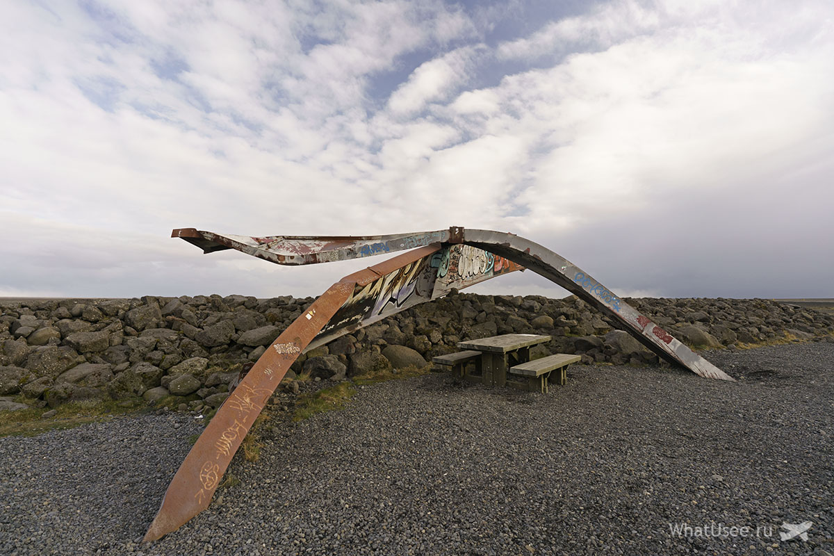
Before entering Skaftafell you can see the rusty remains of the bridge Skeiðará Bridge Monument next to which there is a small recreation area.

And on the other hand, if you go towards Hefn, you will see a beautiful church in the pictures, but creepy in reality Hofskirkja. By the way, the last church in Iceland with a peat roof!

And it is creepy, because it is surrounded by fluffy mounds of graves, which we initially mistook for cute grassy bumps. Then we looked closely - and it became somehow uncomfortable ...
Let's go to the parking lot national park Skaftafell, where we leave the car. Entrance to the park is free, but you will have to pay for parking by purchasing a parking ticket for the day. There are toilets, a cafeteria and many, many buses and cars of various guides and tour companies with which you can go on a tour of the Vatnajökull glacier.
Hiking trails through the Skaftafell National Park start almost from the parking lot. Most of the routes go, of course, to the unusual black waterfall Svartifoss:

 Such a hike will take about an hour one way and is not particularly difficult. As a reward, you will see the most unusual waterfall Iceland - Svartifoss.
Hiking trails varying degrees difficulties in the Skaftafell National Park on the map. The picture can be enlarged.

From the parking lot we walked along short route to the Svartifoss waterfall H1 - H2 - S2 - S6.
Entrance to the Skaftafell National Park on the map. The place on the glacier, which we visited with an excursion, is also marked here.

An excursion to the Vatnajökull glacier must be booked in advance. During the season, places can be sorted out a couple of weeks or even months before the desired date. While we were looking for an excursion to the glacier that was suitable in terms of dates and time, about 10 sites with almost similar offers caught our eye.
After meeting with the team, we go through a brief briefing and dive into a minibus - then the guide will take us to the tongue of the Svinafellsjökull glacier. Yes, the name of this glacier comes from the word "pig" 🙂 Why - history is silent.
Immediately explanation: Svinafell is the tongue of the Skaftafellsjokull glacier and part of the Skaftafell National Park of the same name. The park, in turn, is part of the large Vatnajökull glacier. Most excursions to the glacier in Skaftafell involve going to Svinafellsjokull or Falljokull.

At first, the group moves slowly and uncertainly: we learn how to handle cats and walk in them.
Here the group is still walking along the ground, the tongue of the glacier begins a little further.

This photo shows a triangular mountain, the guide said that episodes with the Wall from the Game of Thrones were filmed here 🙂

Of course, the Wall was then completed on a computer. Well, we are no longer like The night Watch, but to a flock of clumsy hobbits 🙂


The surface of the glacier is all dotted with cracks, forming an interesting ornament. The black color is not dirt, but ash from the Eyjafjallajökull volcano eruption in 2010. In clear weather and in the absence of soot, these faults should be a rich blue color.


And a few more photos from the hike on the Vatnajökull glacier:


That's all. The whole excursion to the Vatnajökull glacier in Iceland took about three hours. An hour to get ready and drive, an hour and a half to hike on the glacier, and another half an hour to get back. We did not face danger, but thrill have not experienced
There are glacier tours with elements of rock climbing and visits to the ice cave, so there is plenty to choose from.

It's time to have a bite! As diligent tourists, we know that the best lunch after physical activity- lunch at fresh air. Therefore, they bought the famous Icelandic lamb and potatoes. Very convenient, because the meat is already pickled and salted, and potatoes are also sold in Icelandic supermarkets peeled and marinated.
All this stuff rode with us around Iceland for the first three days, as the strongest wind made it impossible to put on the grill and light a fire.
As a result, we got tired of waiting and nevertheless built a semblance of a hearth out of stones, despite the weather.
Nice place for barbecue. Close to the Skaftafell National Park and overlooking the Vatnajökull Glacier.

Despite the wind and cold, the steak was ready in 15 minutes.


Bon appetit!


Snaefellsnes peninsula.
Glaciers in Iceland occupy 11.1% of the total area of the country and have a significant impact on the landscape of the island. There are 13 large glaciers, among which the Vatnajökull glacier, the largest glacier in the country, occupies the first place in popularity among tourists. On the map below, you can see the glaciers of Iceland in the form of white spots, a huge white spot is Vatnajökull:
Photo of the tongues of the glacier taken from above:

Vatnajökull glacier in all its glory:

Huge blocks of ice are in constant motion, imperceptible to the eye. The glacier slowly slides down and melts - this is clearly evidenced by cracks on the ice of the melted lake:

At the foot of the southern tongue of the Vatnajokull glacier, between the Skaftafell National Park and the city of Höfn, there is a unique glacial lagoon Jokulsarlon, the depth of which reaches 200 m. The lake appeared in 1934-1935. and as a result of the melting of the glacier, today it has grown to 18 sq.m.


The coast of the glacial lake Jokulsarlon, formed by solidified lava:

A block of ice in the rays of sunset:

It is noteworthy that there are two more glacial lakes near Lake Jokulsarlon.
The wonders of nature associated with the glacier do not end there. In the Vatnajökull glacier, due to hot springs, the Kverkfjöll cave was formed under the ice. In the 1980s, this cave was measured: it turned out to be 2.8 km long and 525 meters wide.


Landscapes of Iceland
Summing up the sights of Iceland, I bring to your attention a variety of landscape photographs of this country in order to make sure once again that Iceland is unusual, and its landscapes sometimes resemble the terrain of other planets from science fiction films.
Young lava fields on which a new ecosystem is being formed:

Thorsmork Valley:

Valahnyukur mountain in Thorsmork valley:

Flocks of silly birds nest in the Thorsmörk valley in the Stakkholt gorge at an altitude of 100 meters above sea level.
Silly in flight:

Since we are talking about birds, it is impossible not to mention a bird called "dead end", of which there are quite a lot in Iceland. This bird with an original color is interesting in that when chasing fish, it dives and swims under water, using both its wings and legs.
Puffin caught a fish:

Let's continue the contemplation of volcanic landscapes:


The Atlantic coast near the village of Vik, from where you can see the rocks of the "Three Trolls":

Rocks "Three Trolls":

Vik village (South Iceland):

In the villages of Iceland, these well-fed sheep are grown:

Separately, it must be said about horses: in Iceland, all horses are very tiny, this is a special breed of "Icelandic pony", originating from the mixing of northern European forest ponies with Celtic ponies brought by settlers to the island in the 9th century.

These small but very hardy horses for a long time in Iceland were the only means of transportation, transportation of goods and even crossing water (Icelandic ponies are excellent swimmers), and field work was also done with their help.

Icelandic ponies can unerringly find their way home, no matter how far they go, so after the annual sheep grading, the farmers who sort the sheep often let the horses go, and they themselves return to their native valleys.


Coast near the city of Husavik:

The city of Husavik is located in a sea bay, ideal for whale watching and fishing. Boats with tourists ply the bay in search of whales. It happens that for the whole day it is not possible to see a single whale, and on another day you can catch a variety of animals performing unimaginable tricks.

Shallow water of the Khvita river flowing through the gorge:


And finally, another feature of Iceland is the northern lights:

If you decide to travel around Iceland by car, then the best route is as follows: St. Petersburg - Vyborg - Turku - ferry - Stockholm - Oslo - Bergen - ferry - Lervik (Shetland Islands) - Torshavn (Faroe Islands) - Seydisfjordur (Iceland). It should be noted that changeable weather in Iceland is a common thing. It may happen that at the end of May there will still be snow, and in December there will be prolonged thaws. Therefore, at any time of the year, equip yourself "with a margin" for unstable climatic conditions, and do not forget to purchase winter tires. And in order not to be a hostage of earthquakes in a mountainous area, not to fall under an avalanche or not to fall into a mud pit, follow the marked tourist routes.