Altai: mystical and anomalous places. The main mysteries of Altai
14 chose
Soloneshnoye - is it a city, a village, a village? Locals proudly call it the regional center Altai Territory. Everything is here: the age-old taiga, impregnable mountain slopes, ringing waterfalls, breathtaking expanses and flowering meadows. A shallow, nimble and in some places quite wide river Anui flows through Soloneshnoye. The name in translation from Altai means "Showing the way". "The way where?" - you ask. "Into the depths of the Altai Mountains, to the secrets and mysteries of ancient civilizations..."

Keeper local traditions, the "owner" of the Soloneshensky Regional Museum of Local Lore adds: "Anui is the path to Belovodie. In our places, Scythians used to live, but not of the Mongoloid race, as is commonly believed, but completely European Scythians. Men were under two meters tall, and women - not less than one hundred and seventy centimeters. Fair-skinned, beautifully built, with long white hair - such were the people. They were born warriors and perfectly kept in the saddle. "

1828 is considered the official date of foundation of the village of Soloneshnoye. There are legends about the ancient Scythians here. They say that they were seen by the first schismatic settlers who chose the valley of the Anui River and its tributary, the Soloneshka River, back in the middle of the 18th century.

Despite the story of the curator of the museum, I came across quite ordinary local residents, of a village appearance: Altaians, Kazakhs and Russians. I don’t know about the warriors, but they are all excellent fishermen. In Soloneshnoye they catch grayling, taimen and burbot.

And now a riddle for the inquisitive: in Soloneshnoye, all the rivers on the road signs are marked as "R. Berezovy", "R. Bystry", "R. Pashin", "R. Nagibin". Like a river, but masculine?! I immediately noticed this strange feature. The answer turned out to be extremely simple: it is customary to call the rivers in Soloneshnoye the keys. It turns out "Birch key", "Quick key" and so on. Everything falls into place. The road builders, as people acting according to the prescription, put the letter "p" and a period on the signs before the local name of the key!

In Soloneshnoye the mountains are green. For "squirrel" you need to go to Belokurikha, where they will show you both the glacier and the permafrost, but from afar. Here is another nature.

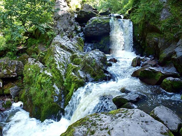
Amateur tourists have chosen the famous healing antler baths. Real thrill-seekers go for rafting on fast mountain rivers or rent horses to climb even higher into the mountains - to the "cascades of waterfalls on the Shinok River".


If you drive a little downstream of the Anui River, you can get into a truly amazing place, which has a special meaning - "Denisov Cave". This is a world-famous archaeological site, listed by UNESCO as a cultural and historical monument. The sites of ancient people from the Stone Age have been found here. And this means that Denisova Cave became inhabited as much as 280,000 years ago!

Altaians call the cave "Ayu-Tash", which means "bear stone". According to one of the legends, a black shaman lived in Denisova Cave. "Once, angry with the locals, he sent rain, which continued for several years. Frustrated people turned to a kind white shaman for help. He expelled the villain, and rolled all the rain into one lump and hid it in the depths of the cave."

Now near the cave there is a research expeditionary base of the Institute of Archeology and Ethnography of the city of Novosibirsk. Research and excavations are in full swing. More than 80,000 unique exhibits of various eras have already been collected: from tools, household items and jewelry, to the remains of animals and plants.

Perhaps I'll show you some more mountains. Not far from this place is an operating gold mine with a developed vein. Simply put, you can try to get gold sand yourself.

This is what happened unexpectedly and educational journey deep into the centuries. What else were mountains for? This is a place of discoveries, new experiences, sunny peaks immersed in emerald greenery, and fresh wind bathing in sparkling noisy mountain springs. Hope you enjoyed!

How do you feel about holidays in the mountains? Have you managed to visit a real ancient cave at least once?
Lyubov Kozyreva , specially for Etoya.ru
Map from the site: http://maps.google.ru/
When God decides to heal a person, he brings him to the place of Power.
Sun Light
If you are ready to go in search of your true self, you have a rare chance to make a real spiritual journey into the depths of your own personality.
Earth - it is a living and very intelligent being. And like any manifested and intelligent being, the Earth has not only a physical shell, but also an energy body, feelings, mind and spirit.
The energy channels penetrating the body of the planet are very similar to those that pass through the energy cocoon of the person himself. These energy "capillaries" of the Earth, through which the Force circulates - a kind of "blood" of our planet - sometimes come to the surface, forming a zone of increased concentration of psychic energy at the exit points.
Mountain Altai is not only the "lung" of the planet and an ecologically clean zone of our hemisphere, but also an esoteric, cult place. Altai is a huge powerhouse of psychic power. The cosmic energies here are so high that transformations take place with people. Gorny Altai is replete with places of Power. Under the influence of these places, the consciousness expands, the body heals, hidden abilities open up. And a pilgrimage to such a good place is like a date with God, after which most of your problems are solved. For the Space of the Spirit is able to give a person much more than he supposes even in his most exalted dreams. Indeed, in such beneficial places, wisdom, love and peace of mind come to a person. Cheerfulness and strength. Silent knowledge and health...
You have to plunge into the magical world of the most amazing and mysterious places in the Altai Mountains. 
The unique and pristine nature, where everything lives in harmony and unity, will surprise you on your journey through the Altai Mountains. The dizzying beauty of mountain passes, eternal snow with sparkling caps of mountain peaks, the grandeur of the taiga, alpine meadows with the legendary edelweiss and the scent of flowers and herbs, and an exotic sight - camels in the steppe against the backdrop of snow-capped mountains ... Along the Chuisky tract there is an abundance of ancient rock paintings - petroglyphs. Here, the usual part of the landscape is burial mounds, ancient Turkic fences and stone statues. They stand motionless for many thousands of years, as if guarding someone's peace...
 You will get acquainted with the Altai way of life, see real villages, try national dishes and drinks. Healing springs and beautiful waterfalls, swift rivers and amazing beauty of the lake will fill you with the energy of Water. The magic of the Altai shamans will enchant you in the rituals of purification and acquaintance with the Spirits of the Mountains. You will comprehend the sacrament of thanksgiving to the Elements at a Buddhist stupa. And near the stupa, any actions acquire the power of a thousand times more!
To test yourself, to feel yourself one on one with nature, to find inner freedom and purity of the Spirit - this is just a part of what the fairy tale named Altai gives you. Beautiful, rich and mysterious land generous to anyone who wants to get to know her better. And you will come back here again and again to find joy, love and harmony!
Tour itinerary
"Mysteries of Altai. Journey to places of Power" - Tour from the cycle - "Knowing yourself"
June 21 - 28, 2019
|
Day |
Description route |
|
|
Arrival in Gorno-Altaisk (airport) or Barnaul. Then transfer to the tourist complex "STICK TRAVEL". Accommodation. Early breakfast. Rest. Introduction to the base. Dinner. Walk around the neighborhood, to Lake Aya. Auradiagnostics, consultation on the result. Dinner. Dating evening. Ecology of the tour. |
||
|
Breakfast. A trip to the healing spring Arzhan-Suu, Kamyshlinsky waterfall. Map of the day, individual tasks and goals when working with Places of the Power of Water on activation portals. Dinner. Dinner. Evening activation. |
||
|
Breakfast. A trip to Chemal, the energies of the confluence of the Katun and Chemal rivers, the island of Patmos, the Church of St. John the Theologian. Work with Places of Power of Water and Ether. Chemal pyramid. Temple of Kalachakra. Temple of Uranus. On the subtle plane - a city, a cosmodrome. Energies of the Pleiades. Purification, emotions of letting go and recharging. Map of the day - individual resources. Dinner. |
||
|
Breakfast. A trip to the Seminsky passes to the relic cedar forests and Chike-Taman, the Kalbak-Tash sanctuary of several eras, the confluence of the Chuya and Katun rivers, the Red Gate, the Behemoth rapids, the North Chuya squirrels (eternal snow), the Kurai Valley. Meditation-activation at the foot of the North-Chuysky ridge. Dinner on the track. |
||
|
Breakfast. Pedestrian walk to the energy rifts to the peaks. Devil's finger, the head of a shaman. Meditation at the Place of Power of the Earth. Expansion of consciousness in the Stream of the Earth's energies, connection with the forces of the Earth. The card of the day is an individual task for meditation. Dinner. Ascent to the top of Malaya Sinyukha to a height of more than 1000 m, from which a beautiful view of the Altai ridges and Lake Manzherok opens. Dinner. Individual work on the birth matrix - goals and objectives of the incarnation (author's technique). |
||
|
Breakfast. A trip to Lake Teletskoye to the Korbu waterfall, the place where the meteorite fell. Unity with the elements of Earth, Water and Ether. Lunch in the mountains. Map of the day - an individual task for harmonization. Dinner at the base. |
||
|
Breakfast. Creating a mental image of your Intention/Goal for its implementation in the Park of Labyrinths. Dinner. Rafting on the Katun (3 hours). Element of Water and Ether. Bath. Dinner. General campfire gathering. Energy of Fire and shaman tambourine. |
||
|
Early breakfast. Departure to the airport. |
||
|
The cost of the tour per person is 49400 rubles. |
Tour dates in 2019:
June - from 21 to 28
The tour price includes:
- transfer airport-base-airport (transfer from the airport of Gorno-Altaisk)
- accommodation - double occupancy in the category "standard"
- complex vegetarian meals on the basis of "STICK TRAVEL", meals on the routes
- tour program
Possible composition of the group: from 10 people.
Teletskoye lake.
 Teletskoye Lake is traditionally considered one of the most popular tourist attractions in Altai. Photos with its views fill the catalogs of travel agencies and illustrated albums. People come here as part of tourist groups, for recreation at camp sites.
The picturesque Teletskoye lake in Altai is called Altyn-Kel, which means "golden lake". According to legend, once there was a severe famine in Altai. One poor man found a piece of gold the size of a horse's head and, hoping to exchange it for something edible, went to the villages. But no one could give him even a little food in exchange for the precious ingot. Then, annoyed and hungry, the shepherd climbed the mountain and threw his treasure into the lake. But, immediately regretting what he had done, he himself rushed into its waves and died.
It is not for nothing that the lake is called the pearl of Altai. Those who have never been to Lake Teletskoye will be fascinated by it from the first minutes. crystal pure water and the endless expanse of the most beautiful lake in Altai cause constant delight. Unique lake. Its other name is Altyn-gol, which means "Golden Lake" in translation. 
71 rivers and countless small streams flow into Lake Teletskoye, and only the Biya flows out, which is born immediately wide and full-flowing and after 306 km, merging with the Katun River, forms the great Ob. The largest of the rivers flowing into the lake is the Chulyshman.
The most majestic waterfall of Lake Teletskoye is the 12-meter Korbu waterfall - a powerful stream, next to which all everyday troubles are instantly forgotten. Water breaks off a rocky ledge, rumbling and flashing rainbows. The spray from the waterfall seems to wash the soul and instill in it peace and a sense of the inviolability of the World. The most daring can plunge into its icy water.
There are simply no uninteresting places on Lake Teletskoye and its environs. Whatever the river, mountain, stone, source - then its legend, history or interesting scientific fact.
 The picturesque bay Stone Bay, surrounded by a chaos of huge boulders, is attractive for its wild beauty.
The two peaks of the mountain Altyn-Tu dominates southern part Teletskoye lake. In the narrowest part of the lake, almost opposite each other, there are two capes - Nyanskoch and Azhi. This is the Dragon Gate. When viewed from a distance, they appear to be adjacent to each other. If you swim closer, the shores slowly diverge to the sides, like the leaves of an ancient gate, letting the ship through, and then close behind you. The legend says that the Dragon Gates allow only people with a pure soul to enter the treasures of the Altai Mountains.
In many respects, Lake Teletskoye can be compared with Lake Baikal: like the latter, about 300 rivers flow into it and only one flows out, the water is clear (in winter time the lake is covered with a thick layer of ice, clearing it of snow, you can see the bottom!) And very cold. Teletskoye Lake is rich in fish, incl. grayling, taimen, Teletsky dace, pike. East End Lake Teletskoye is part of the boundaries of the Altai State Reserve, which is the main scientific center for studying the nature of the Teletskoye region. In the northern part (the village of Artybash) there are tourist complexes.
Attractions.
Mount Tyalan-Tuu. A low (677 m) peak for an easy sightseeing ascent. Excursion prodo  lies for 2 hours, and from the top a picturesque view of Lake Teletskoye opens.
 Third river."Third" it is called by guides. In fact, the name of this river is Tebenek. The river is interesting because it breaks through a shallow gorge with a cascade of small waterfalls.
Stone bay. A beautiful small bay, the shores of which are made of stones - from small  pebbles to huge boulders. There are several versions of its origin. Bold - the bay was formed as a result of the fall of a meteorite, scientific - the bay - the result of the activity of the glacier and Altai - the hero Sartakpai threw the dragon Delbegen to the ground and only a wet place remained from him.
 Korbu waterfall. Waterfall (15 m) in the central part of Lake Teletskoye.
Chemal HPP - business card of the entire Chemalsky district, the first hydroelectric power station in Altai is located on the Chemal River, a few hundred meters from its confluence with the Katun. The Chemal HPP was built in 1935 by the prisoners of SibULON - the Siberian Directorate of Special Purpose Camps. Up to a thousand prisoners worked at the construction site. The power of the station is small, only 500 horsepower (about 400 kWh). This electricity is now enough only for a sanatorium and several residential buildings on its territory. And for that time, the Chemal hydroelectric power station was very powerful, it alone served all the villages of the Elikmonar region. The entire system has been operating virtually without repair for almost 75 years. 
In 1969, during a big flood, the building of the Chemal hydroelectric power station was flooded to the very windows, if you go down to the engine room, then on the southern wall you will see two portraits - Stalin and Ordzhonikidze. Brown traces of water are visible on the portrait of Ordzhonikidze. In this flood, it reached the level of the upper jambs of the building, and this mark remained on the portraits, which have also been in their places for almost 75 years. After a month of repairing the equipment (including drying the windings), the hydroelectric power station was already working again and is still working today.
Tourists are shown sources of "living" and "dead" water near the Chemal hydroelectric power station, they are recommended to experience the effect of "cosmic energy pillars" and try the bungee.
Temple in the name of the Apostle Evangelist John the Theologian (Women's Monastery on the island of Patmos).
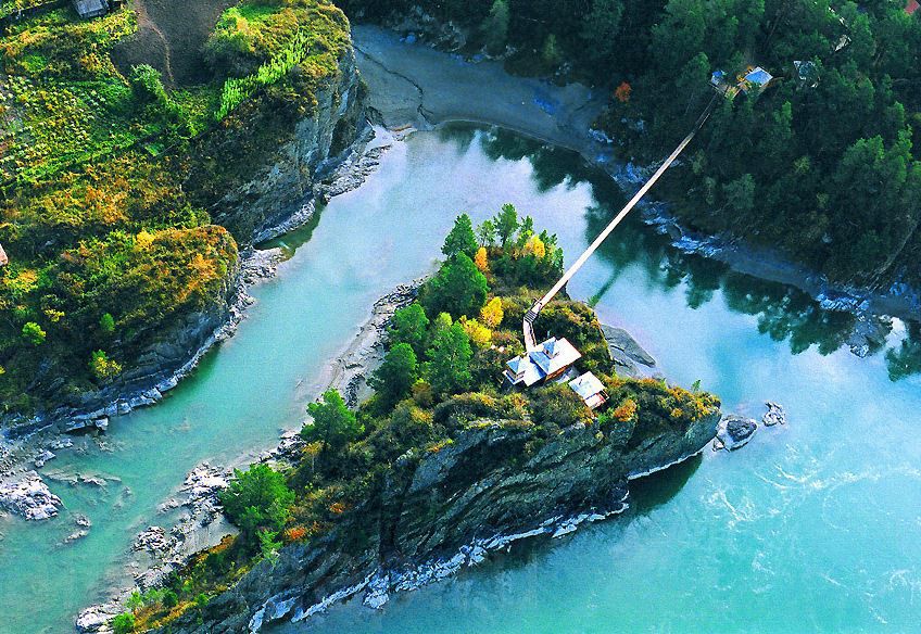 On the Katun Island of Patmos, picturesque place, not far from the village of Chemal, a copy of an ancient temple was recreated. The island itself was consecrated by Bishop Parthentius in 1855. Now there is a women's skete up here. John the Theologian of the Barnaul Znamensky Monastery.
This place is extremely popular with tourists and vacationers. A narrow bridge suspended on cables leads to the island, under which the Katun roars 10-15 meters away and the sensations from such a transition are simply indescribable. These sensations are enhanced by a sign hanging near the bridge, which prohibits more than 8 people from being on the bridge at the same time.
A chapel has been erected on a stone island that has risen above the waters of Chemal, with which people associate miraculous phenomena. The first church on this site was built in 1849. They say that monks lived in seclusion even earlier on the island. On the initiative of one of them - John - the chapel was erected. She received the name of the monk's guardian angel - John the Theologian. And the island has since then been called Patmos - John the Theologian lived on the Greek island with the same name.
Even before the appearance of the chapel, Makariy Glukharev, a famous missionary, the founder of the Altai Spiritual Mission, who brought Orthodoxy to the Altai Mountains, built a small monastic skete. After the revolution, the chapel and cell were burned, firebrands were thrown into the river. A century and a half later, the temple was recreated. This was done by Moscow journalist Viktor Pavlov. He appeared in the village of Chemal in 1991. Ten years later, on January 10, 2001, a temple and a monastic cell were consecrated on Patmos. And on the banks of the Katun River, a nunnery appeared, connected to the island by a graceful suspension bridge.
Already one revival of the temple can be considered a miracle. However, the nuns and parishioners began to notice in this prayerful  place new wonders. For example, a wooden icon was updated before their eyes Mother of God. She got to the temple in a depressing state, the face of the icon was almost invisible. Victor Pavlov intended to give it to restoration, but before that it was placed in the chapel. And she began to heal herself. A face was cut through, formerly blurry robes, images of flowers appeared. As if someone is painting an icon, although the hand of the artist-restorer did not touch it. And the icon placed in the neighborhood is myrrh-streaming. Small, small droplets of moisture appeared on the face, hidden behind the glass. The novices of the temple were at first surprised: it seems that they are diligently wiping the icon, and there are some spots on it. They looked and gasped. Myrrh-streaming! Local priests claim that this icon also hears. That is, you can ask her for what a person wants. According to the priests, on the island of Patmos the Lord shows how icons are painted miraculously and how they weep. This is God's instruction that people repent of their sins and go to temples. No wonder it is in the chapel of St. John the Theologian that the newlyweds aspire to get married. All church requirements are fulfilled here. Recently, a nativity scene was made by the hands of a nun in the rock, at the entrance to the chapel - the birthplace of Christ.
 However, the miracles do not end there. There is another man-made miracle here. It's called beats. Bills are the forerunners of church bells. They are metal plates, different in size. When they are struck with special mallets, unusual sounds hang over the village of Chemal for a long time.
Visitors to the temple can see the outline of the Mother of God with a child in her arms and a halo above her head. This vision opens when looking at a small rock towering on the island of Patmos. According to local beliefs, the miraculous rock is also God's indication of Holy place on Altai land.
Chui tract.
The Chuysky tract on the map is designated as the federal highway M-52, crossing Altai from the northwest to  southeast and connecting Russia with Mongolia. This is one of the few paved roads in the Altai Republic, but the quality of the pavement is pleasantly surprising. The Chuisky tract begins in the city of Biysk, behind the bridge over the Biya River. However, this beginning is symbolic - directly zero kilometer highway M-52 is located in Novosibirsk.
The history of the Chui tract is the history of trade between Russia and Mongolia. The first written mention of the route dates back to the end of the 18th century, when the first Russian merchants entered the valley of the Chui River, not far from the Kurai steppe.
The subsequent strengthening of trade ties led to the emergence of the first merchant transshipment bases - the journey from Biysk to Mongolia was long, and many merchants could stay for the winter at such a base. But mostly they were warehouses for goods. This is exactly the story of the emergence of the village of Kosh-Agach - the largest village in the south of Altai. The date of its foundation is considered to be 1801, when the merchants Khabarov and Tokarev built the first warehouses here. In 1864, there were 10 warehouses and a residential building of the merchant Gilev in Kosh-Agach. The same history of occurrence near the villages of Khabarovka and Shebalino, not far from the passes Chike-Taman and Seminsky.
At that time, Chuisky trade route It was a mountain path, which could only be traveled on horseback. Particularly difficult was the section from Khabarovka to Kosh-Agach, where goods could only be transported by pack.
The first road Khabarovka - Kosh-Agach, suitable for wagons, was built by the end of the 19th century. Later it was improved, however, due to the long absence of repair work, by 1914 the Chuisky tract was in a deplorable state.
In the summer of 1914, an expedition was sent to Altai, the purpose of which was to draw up a plan for the construction of a new road. The work of this expedition was interrupted by the revolution and the civil war, and only at the end of the 20s of the 20th century did the construction of the road begin.
The dispossessed peasants built the road. In total, 10-12 thousand prisoners worked here, who by 1934 managed to complete the construction of most of the tract. In the summer of 1934, the first rally took place, and in 1935-1936 bridges across the Biya, Isha and Katun were put into operation. Of particular interest is the bridge across the Katun in the village of Inya. Built in 1936 according to the project of S.A. Tsaplina, this is the world's first two-cable suspension bridge. Later, the technology of building such bridges was adopted by the Americans and is still used today (for example, the famous "Golden Gate" in Los Angeles).
 In subsequent years, the Chuisky tract was repeatedly repaired and improved, and today it is a modern road with a high-quality surface. Only one difference exists between the Chuisky tract and hundreds of other roads in Russia... These are stories and legends. That is why the Chuysky tract is not just a road. Chuisky tract is one of the sights of Altai.
Red gate.
A beautiful place, which owes its name, firstly, to the narrow isthmus between  mountains, and, secondly, the reddish tint of the mountains. The red color of the rocks is given by cinnabar (mercury ore), which in in large numbers contained in local rocks.
Not far from Aktash village there is a beautiful gorge and a cascade of small waterfalls. A little further, the gorge narrows sharply, until the surrounding mountains practically merge with each other, leaving a space between them of only a few tens of meters - here a place for a road has been punched between the mountains. This place is called the Red Gate. The road here runs right between two walls several tens of meters high. From large stone boulders opens beautiful view to the lower cascade of a mountain river.
Seminsky pass
 Seminsky pass is a popular place among tourists and vacationers. It is also the highest point of the Chui tract. Its height is 1894 m (according to other sources 2200 m) above sea level. The ascent to the Seminsky Pass has a length of 9 km, and the descent is 11 km. However, both the ascent and descent are not as spectacular as, for example, at the Chike-Taman pass, although they have much great length. The old Altai name for the Seminsky pass is Dyal-Menku.
The vegetation of the Seminsky pass is very diverse. Here is the main  part of the plants of the Altai Mountains. The cedar taiga is interspersed with subalpine meadows and mountain forbs. Far from the road, you can find glades covered with flowering maral roots. At the top of the pass, alpine meadows dazzle, and then shrub tundra, overgrown with dwarf birch and alpine willows, with clearings of snow-white cotton grass. The road passes among cedar groves, and in the month of August on the top of the pass there are numerous vendors selling cones, pine nuts, tinctures from the roots. They also cook and sell excellent shish kebab.
In commemoration of the 200th anniversary of the entry of Gorny Altai into Russia in 1956 on highest point On the pass road through the Seminsky Range, a memorial obelisk was erected. A picturesque panorama of the blue Altai, Sarlyk Mountains (2507 m), cedar groves opens from here. From the Seminsky Pass begins an 11-kilometer descent into the valley of the Ursul River, to the village of Tuekta. Previously, the road through the old Seminsky Pass was to the right (about 10 km) and descended into the upper reaches of the Peschanaya River, and then through the small pass Kamennoye saddle went to Tenginskoye Lake and the village of Tenga.
The Seminsky Pass is a kind of border between "organized-civilized" and "wild-exotic" tourism. In the villages located on the Chuisky tract beyond the Seminsky Pass, traditional Altai buildings are increasingly visible, and the Altai population begins to prevail over the Russian. After the pass tourist bases and the complexes gradually disappear and give way to pristine nature, practically untouched by man. The gray-haired old man Altai comes into his own, and you are invited to his mountain domain!
Chike-Taman pass
 The Chike-Taman pass is located on the Chuisky tract behind the Seminsky pass. The height of the Chike-Taman pass is 1460 m, however, due to its steepness, it seems to be much higher. For those who drive through this pass for the first time, the steepness of the climbs, sharply winding roads, steep cliffs on the sides and opening mountain panoramas are simply breathtaking! Photos do not convey even a hundredth of the sensations from moving along a mountain serpentine. But, despite all its entertainment, "Chike-Taman" is translated from the Altai language as "flat sole"!
The northern slopes of Chike-Taman are completely covered with deer. In early spring, yellow Altai tulips bloom on the southern slopes. In the area of the Chike-Takan pass, the Chuisky tract in former times was very difficult and dangerous for horses, for which it was more than once scolded by coachmen "This is not Cheketaman, but Devil-ataman, forty-eight sins." Everything is said in this, all the bile of a man who has abused to the utmost, who has tortured himself and killed here, perhaps, more than one horse, is poured out.
On the saddle of Chike-Taman there is a larch, on the branches of which white rags are tied. This so-called shaman  a tree that in the Altai Mountains can be found on passes, near streams and springs. Travelers have long tied ribbons in gratitude to the spirits of the place and in memory of those who stayed at home and who are waiting ahead.
Large repair work on Chike-Taman was started in 1924-1925, and in 1927 the tract was laid along a new route. new road, on which they travel today, was put into operation in 1984, and it is already difficult to imagine that a few decades ago this pass was one of the most difficult and dangerous tests for travelers. From the pass Chike-Taman offers a magnificent view of the huge mountain ranges, rocks and old road, winding below.
Stone steles and petroglyphs near the village of Inya.
 Behind the village of Inya, located on the Chuisky tract, a few tens of meters to the right of the road, there are four stone steles. Two of them are quite large - more than 2 meters, and two are smaller. Perhaps they were used as a fence for the ancient Turkic funeral complex. A few meters from the stelae is
  mound. It is noteworthy that there is a huge field around, on which there are no stones from which this mound could be erected. Where the stones were taken for its construction is unknown. It also remains a mystery where the stone blocks for the manufacture of the steles themselves were taken.
 According to archaeologists, there used to be another stone sculpture dating back to the Eneolithic era. Its upper part was recaptured already in our time and is now in Museum of Local Lore Gorno-Altaisk. All the steles face north with their symbolic faces and have been standing motionless for thousands of years, as if protecting someone's peace.
On the right bank of the Chuya River, between the villages of Inya and Iodro, on the rocks along the road, ancient petroglyphs are found almost continuously for 10 km. In general, there are more than 3 thousand images of different times from the Bronze Age to the Middle Ages and 20 ancient Turkic runic inscriptions.
This place was called the Kalbak-Tash tract. The literal translation is "a flat, expanded, hanging stone,  mountain". However, on some maps it is designated as "Bom-Tash". The complex of petroglyphs is located on the rocks of greenish-brown shale not far from the road, on the left side. Surprisingly, in addition to the symbolic drawings of animals and people, many of the drawings depict objects , shaped like modern spaceships with a capsule attached to the hull at the top and large tongues
  flames below! You involuntarily think about the fact that our distant ancestors were frequent witnesses of space flights. The drawings of "Spaceships" are drawn larger than the images of animals and people. They are located on horizontal slabs and therefore their outlines are more blurred - due to the greater impact natural factors and the gradual erasure of the shoes of people who have been here for many centuries. Because of this, it is difficult to convey these drawings using photographs, but upon visual inspection, they literally
  bewitch!
Approximately 2 km from the rock paintings, there is a statue of a stone warrior with a clearly depicted face and a hand holding a sword. Behind the statue, in a small ravine 200-300 m from the road, there is another petroglyph. The age of stone sculptures and drawings is several thousand years!
Kurai steppe.
 The Kurai steppe has a harsh climate: short hot summer days are replaced by snow blizzards and severe cold. The sharp temperature difference in summer and winter, as well as day and night, is explained not so much by the altitudinal position of the steppe, but by strong cooling in a cloudless sky. The same phenomenon is also characteristic of the Chuya steppe.
The Kurai steppe is located in a large intermountain basin and is surrounded by ridges. Height above sea level 1500-1600 meters. The Chuya River flows through the steppe, which is quite calm here and not as stormy as below. Peaks are visible from the village of Mena  North-Chuysky ridge.
The Chuya tract passes through the dry Kurai steppe, strewn with small and large pebbles. Here, before reaching the Chuya steppe, the influence of dry Mongolia is already felt. Around the rare and inconspicuous vegetation with a predominance of wormwood and thorns. On the left, the desert steppe is surrounded by very beautiful pink-colored folded rocks, and on the right, the snowy peaks of the North Chuya Range.
Behind the small village of Kurai there are several large excavated burial mounds. In one of the mounds, excavated in the 30s, the remains of a noble Turk were found in a log with an accompanying burial of three dead horses and, presumably, a slave. Among the things placed in the grave, a silver jug and a belt tip with runic inscriptions were found. The Chuysky tract rushes into the distance among the desert landscape of the Kurai steppe. A little before reaching the village of Chagan-Uzun, on the right is a unique poplar grove for these places. Here, the Chagan-Uzun River flows into the Chuya River from the left side. Rock paintings were discovered 2-3 km upstream of the Chagan-Uzun.
 In the Kurai steppe, on the left bank of the Chuya, in the Tete tract, one of the most famous monuments of the Altai Mountains was found - a stone statue of a kezer, a symbol of art
 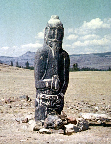 Turkic period. This masterpiece of the work of an ancient master is admirable: the facial features, beard and mustache of a formidable warrior in a headdress and with ringed earrings in his ears are perfectly conveyed. right hand vessel. The figure of a keser is voluminous. The height of the statue is more than 1.5 m, the thickness in the belt is 0.75 m. Unfortunately, today it is impossible to see the ancient stone warrior in his "native element": the statue was taken out of the Kurai steppe and is now kept in the funds of the Gorno-Altai Republican Museum of Local Lore.
Tavdinsky caves.
 Opposite the source of Arzhan-Suu and the village Izvestnyakovy on the opposite (left) bank of the Katun River are the famous Tavdinsky caves. You can get to them by moving across the Katun along the bridge leading to the Turquoise Katun tourist complex.
The caves got their name from the name of the village of Tavda (the second name is Talda), which was previously located not far from these places. The length of rocks with caves (of which there are more than 30) is about 5 km. cave holes  are located in sheer cliffs and cliffs, but it is not difficult to get to them. In several caves, researchers observed traces of recent human habitation. Either someone escaped in the caves during the civil war, or hermits-strao-believers were hiding there earlier. Since the 1960s, the caves have attracted the attention of speleologists and karst explorers from all over the country.
Archaeological finds have been made in the cave known as "Bolshaya Tavdinskaya". Another name for this cave is girlish tears. This is the most visited cave in the Tavdinsky massif. The lower entrances to it are located 70-80 km from the road and are visible through the gaps between the trees. The main gallery is quite spacious and gradually rises. The difference from the lowest entrance to the highest one is 23 meters. On the last 40-meter section, in front of the highest entrance, the gallery, rising, twists in a spiral, overlapping its lower part and forming a ledge. In the distant past, the Tavdinsky caves served as housing for humans. During archaeological sites pottery and fishing accessories were found in them. Found also  items from the Bronze Age. The Tavdinsky karst arch is unique. It represents a rare form - the remains of the vault of a karst tunnel or cave, which originally had the appearance of a wide span - a bridge, and later - an arch. The Tavdinsky Arch is located at an altitude of about 80 meters above the water level of the Katun River. The width of the through hole of the arch ranges from 3 to 13 meters, the height - from 3 to 5 meters. The vault of the arch, 5 meters thick, is covered with rare herbaceous vegetation and pines Since 1996, the Tavda karst arch has the status of a natural monument.
The nature of the use of the Big Tavdinsky cave has not been fully clarified, but many scientists believe that, most likely, the cave was a sanctuary.
Several powerful places of Power are located on the highest mountain of Altai - Belukha. Beluga whale- sacred to many  mountain peoples. Altaians call it Uch-Sumer, which means "Three-headed", although in fact Belukha has two peaks - Western (4435 m) and Eastern (4506 m). Even in summer, this mountain is almost completely covered with eternal snows, and therefore its second name is Ak-Sumer ("White Head"). The third name - Kadyn-Bashi ("Head or House of Katun") Belukha received because from its slopes, from the Gebler glacier, the Katun River originates - the most full-flowing river of Altai, which, when confluent with the Biya, forms a great Siberian river Ob.
 Many esotericists and mediums claim that the strongest energy fields are located here, and the famous philosopher and artist N.K. Roerich seriously believed that somewhere here, on one of the slopes of Belukha, there is an entrance to Northern Shambhala - the country of eternal happiness. And until now, the followers of the great artist and philosopher rush to the foot of highest peak Siberia. Among the ancient Aryans, who professed Buddhism, the great mountain Sumeru was considered the center of the Universe, around which all the stars and planets revolved. All the Deities of low and middle rank flew to her to honor the Lord of the Universe and ask for help or advice on certain initiatives.
The energy of Ak-Sumer is mostly fiery. And although the power of Fire is the most powerful cleansing agent, there is such garbage in a person that only Water can do.
Gorny Altai is replete with places of Power. And, receiving fertile energy from our Mother, the planet that loves us, we must always say thank you to her. For she feels everything, knows and understands how difficult it is sometimes for a person and how much he needs her help ...
To immerse yourself in the mystical atmosphere of the amazing mysteries of antiquity, you do not need to leave Russia. Many probably know that Altai has long and deservedly been called the cradle of the world, which means that it is from here that humanity began its long and difficult journey. (website)
Altai Princess Ukok
Ukok is a sacred plateau in the south of Altai, very attractive for adventure seekers. It gained wide popularity in 1993, when, having opened an ancient burial ground, archaeologists discovered the mummified body of a 25-year-old girl in it. The mummy itself was at least two and a half thousand years old. Restoring the appearance of the girl, scientists found that her facial features were European, not Mongoloid. The unique find was called "".

In life, the "princess" was a warrior, as indicated by the red sash around her waist. In the hand of the mummy was a small wand made of larch, which was considered one of the tools of the "creation of the world", and on the head - a special dress: only women who wielded magic could wear this - the so-called keepers of the "mystery of immortality". The skin of the mummy had animal tattoos. Things lying near the body indicated that the girl was not an ordinary person. Scientists suggested that they discovered the mummy of Kydyn, the progenitor of the Altai people. By the way, local shamans were against the researchers opening the burial, and warned that otherwise Altai land incalculable troubles await (later it happened).

However, this is not the only secret of Ukok: mysterious geoglyphs were discovered here - huge images applied to the ground, which can only be seen from a height. For what purpose geoglyphs were created is still unclear, but scientists have established the approximate time of their appearance - the third century BC. How the ancient geoglyphs managed to survive to this day is another mystery.
Other mystical places of Altai
No less famous is the so-called Altai stonehenge - a mystical complex of five boulders decorated with petroglyphs, the height of which is about 7 meters. The stones were most likely brought here from somewhere, since there is no such material in the neighboring mountains. Altai legends say that the boulders were brought here and installed by the ancient Scythians, and then the local shamans began to use this place for their rituals. Altai stonehenge was created in the VIII-VI centuries. before the new era. Its stones strictly correspond to the cardinal points and have differently charged electromagnetic fields. Eyewitnesses say: if you stand in the center of the complex, you can feel how you are being pulled into some kind of funnel.

Denisovskaya cave - another mystical place in Altai. Located in the valley of the Anui river, this cave is considered "the path to Belovodye". Fragments of the remains of a little girl and a young man were found here, which anthropologists carefully examined and attributed to an ancient unknown human population. The new species was given the name - "Denisovets". He, according to scientists, once separated from the main branch of humanity, after which he evolved his own way, which later turned out to be a dead end. Thanks to this find, a theory arose that about 50 thousand years ago western part Eurasia was inhabited by Neanderthals, and.

mystical stories veyana and the Altai mountain Belukha, which is located at the same distance from the Pacific, Indian and Arctic oceans. In this place, you can observe the constellation Ursa Major all year round.
Mystical place Belovodie - Altai Shambhala
Many people associate legends about the country of Belovodie with Altai, which was considered the abode of freedom and immortality. The Russian scientist, philosopher, artist and traveler Nicholas Roerich, who considers Belovodie an analogue of Shambhala, argued that there is a strong connection between Altai, India and Tibet, that these are links of one energy system, which was once created by the inhabitants of Atlantis. Of course, it is difficult to say whether modern people find a way to the country of universal justice and virtue - Belovodie, since the solution of this problem is in the spiritual sphere ...

Altai is an amazingly beautiful place. Its magical meadows with blooming edelweiss, crystal clear rivers and lakes, primeval forests eloquently testify that here is a mystical place of power, here is the energy point of our planet.
Altai is called the "Cradle of the World", believing that it is from here that humanity began its journey. This sacred land still holds many mysteries.
The meaning of the Turochak inscriptions
In 1975, on sheer cliffs near the left bank of the Biya River, seven kilometers from the village of Turochak, amazing two-meter rock paintings were discovered: more than two dozen rapidly “walking” moose.
A stylistic analysis of the images made it possible to attribute them to the Bronze Age and, with a high degree of probability, to associate them with the Karakol culture that existed in the 2nd century BC. But how these rock carvings, unique for Altai, appeared is still not completely clear. Distinctive features Turochaksky pisanitsy became not only the material with which the drawings were created - red ocher, atypical for Altai petroglyphs, but also the choice of characters.
The researchers were also struck by the dynamics and expressiveness of the images that distant ancestors were able to create on a steep and hard-to-reach surface. But the main mystery remains the meaning. What did the ancient "artists" try to tell their descendants?
Woman with a tattoo

The sacred Ukok Plateau in the south of Altai is a place that attracts both daredevils who decide to "test themselves" and numerous researchers. His main riddle world science community It began to be discussed relatively recently, in 1993, when archaeologists led by Doctor of Historical Sciences Natalya Polosmak, during excavations at the Ak-Alah burial ground, discovered a mummified body, the estimated age of which is 2.5 thousand years.
The perfectly preserved find allowed scientists to conduct a DNA examination and restore the appearance of a 25-year-old girl. Her features were not Mongoloid; appearance, rather, resembled a European one. The waist of the "Princess of Ukok" was decorated with a red belt - a symbol of a warrior, in her hands she squeezed a larch wand - an instrument of "creation of the world", and her head was crowned with a high headdress with golden braids - an attribute of a woman with magical powers and keeping the "secret of immortality".
On the body were found tattoos made in the Scythian "animal" style in the form of deer-capricorns with the beak of a griffin, a ram with a thrown back head and a spotted leopard. All this, as well as a leafy deck, similar to a shamanic boat "rotyk", and six "heavenly" horses buried here, indicated that not a common person. Altai shamans are sure that this is the body of the legendary progenitor of their people - Kydyn, with the "desecration" of the burial place of which all the troubles of Altai began.
Academician Vyacheslav Molodin, under whose leadership a large-scale study of the high-altitude Altai was carried out, is convinced that “this is not a princess, but a representative of the middle layer of the Pazyryk society” of the 6th-3rd centuries BC. Perhaps she was a fortune-teller or a healer, however, who the “Altai Princess” really was and what her name was, will remain a mystery.
The eighth wonder of the world

The Ukok plateau has other secrets. For example, mysterious geoglyphs were discovered here - huge images that can only be seen from considerable distances, usually from a bird's eye view. It is not clear for what purpose they were created.
The age of geoglyphs is another controversial issue. For a long time it was assumed that they appeared one and a half to two thousand years ago, but the latest research has suggested that the time of their creation is the 3rd-2nd centuries BC. Scientists are also trying to understand why geological processes have not destroyed geoglyphs over such a long period of time?
Finally, they have yet to understand the meaning of the "messages". Although the contours of many of them are easy to "read", the "idea" of the ancient artists is still a mystery. Scientists rightly call geoglyphs the eighth wonder of the world and continue to search, while ufologists are trying to support their theory about the location of alien airfields in these places.
Altai stonehenge

Thousands of tourists visit the Chuya steppe to see the Altai stonehenge. Five huge boulders up to seven meters high are decorated with petroglyphs - drawings from the time of the Pazyryk culture. One of the boulders differs from the rest by the crossbar placed on it, the other is made in the form of a chair-throne.
Researchers are sure that ancient shamans used this place for rituals. At the same time, probably, the stones were specially delivered from other places - a comparison of their structure showed that the material is not found in the nearby mountains. According to legend, the boulders were brought by the ancient Scythians from an area 500 kilometers away.
The age of the Altai stonehenge presumably dates back to the 8th-6th centuries BC. The stones are set in the direction of the cardinal points and, according to observations, have differently charged electromagnetic fields. Tourists who dared to stand in the center of the "stone fence" said that they were "as if being sucked into a funnel." The true purpose of the Altai Stonehenge and its "magical power" are still being guessed at.
"Denisovets" or "Altai man"
Denisovskaya Cave is located in the valley of the Anui River, which the keepers of Altai traditions call "the path to the mysterious Belovodye". Many cultural and historical monuments have been discovered in this world-famous archaeological site. In 2009, among other finds, a phalanx of a finger of a little girl was found, and a little earlier, a molar tooth of an 18-year-old boy.
The artifacts were sent to the M. Planck Institute for Evolutionary Anthropology in Leipzig. The analysis showed that their owners were representatives of a new ancient human population. While Russian, American and Canadian scientists find it difficult to give an exact answer: whether it is a new species or subspecies, therefore, they use a neutral one - “Denisovets” or “Altai man”.
Presumably a million years ago, he "departed from the branch general development human,” and evolved independently, as it turned out, in a dead-end way.
Denisovan genes have not been found in any representative of modern civilization, with the exception of the Melanesians, whose ancestors, according to scientists, could contact the Denisovans in East Asia.
The discovery completely destroyed the stereotypical idea of the ancient inhabitants of the planet and suggested that Neanderthals lived in the western part of Eurasia 50 thousand years ago, and Denisovans lived in the eastern part. Could they interact, and what caused the disappearance of the "Altai man" - questions that have not yet been answered.
Center of the Universe

Many researchers correlate the highest Altai mountain Belukha with the sacred mountain Meru. In particular, the Russian philosopher Nikolai Fedorov tried to confirm this theory. Based on a map depicting the sacred Mount Meru, dated to the 2nd century BC, the Turkologist Murat Adzhi supplemented the popular hypothesis.
One of the arguments was the similarity of the location of ancient Meru and modern Belukha. At an equal distance from Meru were four oceans known then, and Belukha is equally removed from the Indian, Pacific and Arctic oceans. Where did the fourth ocean go? Perhaps it existed west of Belukha during the time of Atlantis, but subsequently disappeared. Among other "evidence" they call the opportunity to observe the Big Dipper over Altai all year round and the consonance ancient name Beluga whales "Uch Sumer" with the toponym "Meru".
In search of freedom

In the Russian mind, Altai is inseparable from the legendary and mystical country of Belovodie, the abode of freedom and immortality. It is customary to associate the popularization of the legend with the Old Believers-runners who flocked to Altai in search of a better life and showed the way to all those who were thirsty with the help of “guides”, where the path to Belovodie was described in an allegorical form. The Russian scientist and philosopher Nicholas Roerich associated the Slavic idea with Buddhist traditions about Shambhala. He announced the inseparable connection between Altai, India and Tibet and was sure that they were components of a single energy system that had been preserved since the time of Atlantis. Is it possible today to find a way to the Land of Justice and Virtue? - the search for an answer to this question lies, rather, in the field of spiritual knowledge.
Altai is the sacred land of the peoples of Siberia. It is Altai that some scientists consider the ancestral home of mankind, its Noah's Ark. It is proved that the Altaic language family includes more than a hundred languages and dialects. Its representatives can be found in different countries and on different continents. These are representatives of the Mongolian, Samoyedic, Korean, Finno-Ugric and Japanese language groups.
Some believe that Altai is not only ancient center from which mankind settled throughout our planet. This is also the place that will survive in all the cataclysms of the future. In addition, some believe that it is in Altai that the sacred center of the Slavs is located - the mystical country of Belovodie. A country ruled by a Christian king, where reigns eternal spring and the immortals live. This legend was once popular among Russian Old Believers. They flocked to the Altai, fleeing the royal persecution, and also in order to find this magical land.
The philosopher and scientist Nicholas Roerich popularized this Russian legend about Belovodye by comparing it with the Indian Shambhala. Having announced the connection between Altai, Tibet and India, Roerich was sure that all these places form a single energy system that has been preserved since the time of Atlantis - he ensured a constant influx of pilgrims to Altai.
Many people seriously consider Altai to be the "Cradle of the World". Such an unusual status is given to Altai by its sacred mountains.
In general, Altai is a mountainous region. Belukha is the highest of the Altai mountains. It has two peaks. The eastern peak rises to 4506 m above sea level. And the Western Peak is at 4440m. Climbing Belukha is possible only in summer. Of course, Belukha is one of the sacred mountains Altai. It is her, many researchers correlate with the legendary "Mount Meru". This idea belongs to N. Fedorov, a Russian philosopher.
The ancient Indian "Mount Meru" is now impossible to accurately correlate with any known to us mountain peak. She is the true center of the Universe, whose invisible part of the top goes deep into the Cosmos, and there the Moon, the Sun, stars, galaxies revolve around it. preserved ancient map, dated to the second millennium BC, which depicts "Mount Meru". On this map, it was located north of India, and all four oceans known at that time were at an equal distance from it. And according to these astronomical data, Turkologist Murat Adzhi supplemented the hypothesis of N. Fedorov with new scientific data. It is above Altai that you can see the Big Dipper all year round. And here, over Altai, one can observe a full rotation of the planets. Mount Belukha is indeed at the same distance from three oceans: Indian, Pacific and Arctic. As for the fourth ocean, it is assumed that one really existed west of Belukha during the time of Atlantis. But later disappeared, after a series of serious cataclysms.
In addition, the very name "Meru" is consonant with the traditional name of Belukha - Uch Sumer. The last word, "Sumer", scientists produce just from "Meru".
In second place in importance after Belukha is Mount Altyn-tu. Its name translates as golden mountain. On it, according to the legends of Altai, is the eternal throne of the creator of our world, Ulgen. Here he rests after he created the sky, earth, rivers, people and animals. He almost does not interfere in the affairs of people, but this does not mean that you can test his patience with impunity.
All Altai mountains, including Belukha, have a single owner. His name is Altai-eezi. He lives, of course, on Belukha itself, but it can also be found on the tops of other mountains. Altai-eezi lives in numerous caves where the glaciers start. Representatives of the indigenous peoples of Altai knew this, and never, even for a huge reward, agree to climb the glaciers. Ice is that visible border that separated the world of people from the realm of spirits. And the spirits severely punish anyone who dared to break this law. They punish not only him alone, but his entire family, as spirits always do if a person violates the prohibitions established by them. And the punishment of spirits can be terrible. Spirits send frightening snow storms in winter, hopeless rains at any other time of the year. They can kill all the cattle in the village, deprive the hunter of good luck, so that he will no longer bring back a single killed animal from the taiga. Each such punishment threatens death from starvation to the entire tribal settlement.
To appease the formidable Altai-eezi, rich sacrifices are made to him. These are sweet cheese, milk and chegen (a local analogue of kefir). And be sure to bring a ram with special signs as a gift. He should have a snow-white coat, and his head should be red.
These commodity-contractual relations with the spirits ultimately brought great benefits to Altai itself. It is in these places that almost untouched nature has been preserved in its original form. Local residents are sure that the land here is able to stand up for itself, which has not happened in other places for a long time. Many times people have been the victims of accidents due to improper hunting - by killing an animal that should not be killed in this season, or by killing too many animals, poisoning fish or cutting down trees. Death or severe injury was the punishment of the spirits for this.
In addition, in Altai there are a lot of sacred mountains of a lower rank. These are the so-called ancestral mountains - yyk-tu. They are so called because they are located on the territory of some kind. Such mountains also have an owner - tu-eezi. They also monitor the order so that people do not take from nature more than they need for life.
Traditionally, in the view of the inhabitants of Altai, the sacred mountain is not just a stone. It is always hollow inside, and has doors invisible to the human eye. From them in the spring animals come out into our world, and birds fly out.
Where did such a view of the mountains as treasure chests come from? Why should one not approach the sacred mountains? Who actually protects the nature of Altai from human encroachment? Perhaps this ban has existed for a long time, and has a purely pragmatic function - to protect the artifacts of ancient civilizations from immoderate and destructive human curiosity. It is possible that inside the caves of the sacred mountains there are special tunnels that connect these mountains with the mountain complexes of Tibet, India, Tien Shan. But this is only one of the hypotheses.
According to another, this underground mountain world is inhabited by completely different creatures. Mysterious snake people or dragon people live there, who gave man writing, medical knowledge, laws and agricultural technologies. Legends tell about this ancient patronage of highly developed reptiles not only in Altai, but all over the world - India, China, Iran, Egypt, Greece. Why all of a sudden these creatures broke off all communication with humans and no longer rise to the earth's surface remains unknown. Perhaps these mysterious creatures are still watching a person. And they even keep in touch with us through their intermediaries - shamans.
No related links found


