Where is the Strait of Gibraltar located? Strait of Gibraltar. View of Africa from Europe - Travel page
Even the most ancient navigators knew about the Strait of Gibraltar, but then it was considered the real geographical end of the earth and the symbolic border between the world of people and unknown world. Some believed that if you stumble here, you can fall off the Earth, falling over its edge.
This strait, which gave rise to many myths, separates Europe and Africa and connects with. It is located on the European side at the southern tip Iberian Peninsula, and from Africa - from her northwestern shores. At its narrowest point, the strait reaches only 14 km, so that the coasts of two continents can be seen simultaneously.
The shores of the strait are rocky: Europe rises above the ocean in the form of a monolithic limestone rock of Gibraltar (426 m) located on the territory of Spain, and Africa - the Moroccan mountain Jebel Musa. These elevations in antiquity were perceived " last points mainland", and the strait itself was associated by sailors with a passage between the rocks. Thus, the concept of Gibraltar "pillars" that passed from people to people appeared in culture. By the name of their god - the patron saint of navigation - the Phoenicians designated this place as the "Pillars of Melkart". The Greeks also called him the "Pillars of Hercules" and believed that in this way their hero marked the edges of the Oikumene (that is, the part of the world mastered by mankind). The Romans nicknamed the rocks the "Pillars of Hercules". The legend says that along the edges of the strait, the tops of the rocks were crowned by two colossal statues standing on columns-steles - hence the word "pillars". The statues marked the transition to the world of the unknown.
Story
The modern name appeared around the 8th century. and is associated with the name of the leader of the Arab troops who invaded here in 711, Tariq ibn Ziyad (670-720). The destruction of the legendary statues is attributed to the Arabs. They built a fortress, which was given the name of the leader - "Tariq Mountain", which in Arabic sounded like "Jebel-at-Tariq". Over time, this name was simplified to the variant "Gibraltar", from which it passed to the familiar "Gibraltar". Now this is the name of the strait, the mountain and the city.
The Arabs held their power over the strait until 1309, when the Spaniards briefly managed to liberate these lands. After the defeat of the Spaniards in 1333, the fortress again fell into the hands of the Moors. Until 1462, the Spaniards could not change the situation, and the Europeans fell into dependence: Arab and Berber (African) pirates founded the port of Tarifa and demanded tribute from everyone passing through the strait. According to one version, the word "tariff" came from the name of this town.
In 1469, the marriage of Isabella I of Castile (1451-1504) and Ferdinand II of Aragon (1452-1516) marked the beginning of the subsequent unification Spanish provinces into a single state, the Arabs were gradually ousted from the Pyrenees, and the remaining Muslim population was subjected to forced Christianization. Then Queen Isabella granted the city of Gibraltar, which grew around the fortress, a coat of arms with a symbolic image of a golden key, bequeathing to her descendants to keep Gibraltar at any cost. Charles V (1500-1558) fulfilled Isabella's will and really turned the Gibraltar fortress into an impregnable bastion, which allowed the Spaniards to hold it until the beginning of the 18th century. It is believed that since that time the proverb “Impregnable like a rock” has remained in many languages, in which this fortress is meant by “rock”.
Given the importance of Gibraltar for the Spaniards, there is another version of the origin of its name. The word is divided into two parts: "Khiber", i.e. Iberia (future Spain) and "altar", meaning "altar", "altar". In this version, the meaning of the name acquires a different symbolism: "Iberian (i.e. Spanish) altar."
But in 1704 the fortress was captured by the British - during the War of the Spanish Succession (1701-1714). According to the Peace of Utrecht signed in 1713, the Gibraltar fortress was ceded to Great Britain. Fourteen times Spain tried to recapture the fortress, but failed. The loudest British victory was the battle in 1805 at Cape Trafalgar at the entrance to strait of Gibraltar. Then, Admiral Horatio Nelson (1758-1805), who was mortally wounded in battle, led the British troops to victory over the combined Franco-Spanish fleet of Napoleon I (1769-1821).
The importance of this victory for the British can be judged by many facts: the legendary admiral, as a true hero of the nation, is buried in Westminster Abbey, central square London is called "Trafalgar".
Because of this centuries-old territorial dispute, relations between England and Spain were more than once complicated and even interrupted. In 1985, an agreement was entered into on the equality of the rights of Gibraltarians in Spain and Spaniards in Gibraltar, and at the same time the border between these states was opened.
The British have a sign: as long as rare Magot monkeys live on the Rock of Gibraltar, the dominion of England will not end here. After the remark of the British Prime Minister Winston Churchill (1874-1965) about the dangerous decrease in the population of monkeys, the post of "officer in charge of monkeys" was established.
Since air base Gibraltar November 8, 1942 began the operation of the Anglo-American troops to land on the coast North Africa called "Torch", i.e. "Torch". True, the Nazis managed to contain this pressure.
Today, the British position their base as a pan-European one, which is simply maintained by England. It hosts the western link of the chain of NATO Mediterranean naval bases.
The capital of the rock-state is the city of Gibraltar, which looks like a typical Mediterranean port, living with a mixture of different cultures: in architecture, buildings in Georgian and Victorian styles interrupt buildings with features of Spanish-Portuguese, Genoese and Moorish influences, and their own language locals ironically called "spanglish". Gibraltar offshore zone. The British presence is reminiscent of the names of streets and various establishments, an abundance of pubs, policemen in English uniforms and the currency - the Gibraltar pound.
On the opposite side from the British Gibraltar is the territory of Morocco. The most significant settlement in this part of the country is, of course. The city has no less remarkable history than its neighbors on the other side of the strait. For half a century it constituted the international zone of Tangier. Territory with a special status, which in 1912-1956 was governed by several European states(France, Spain and UK). But during the Second World War, the balance of power changed. France occupied by the Germans could no longer control its section of Tangier, it was occupied by Spain. And at the end of the war Arab population"zones" began to gain weight and showed dissatisfaction with the presence of Europeans.
As a result, in 1956, the Moroccans annexed Tangier. Now it's big seaport, retaining its autonomy and strategic importance. It remains the most Europeanized in the country - the French, Spaniards, Germans, Italians, British and other Europeans (including a small Russian-speaking enclave) constantly live in it. Not only mosques are noticeable on the city skyline, but also Catholic, Protestant (Anglican and Lutheran) churches, synagogues and other places of worship.
During its history, the Strait of Gibraltar closed and opened at least 11 times. This happened, for example, 6 million years ago - the closure of the strait led to an increase in salinity in the Mediterranean Sea and the formation of a layer of evaporites (a product of evaporation of salt water) 2 km thick. Approximately 5.3 million years ago, the strait reopened, which allowed the Mediterranean Sea to "come to life". The movement of lithospheric plates will lead to another closure of the strait in a few million years.

general information
Countries: Spain, Morocco and Gibraltar ( overseas territory Great Britain).
Extreme points: Capes Trafalgar and Carnero (Europe), Cape Spartel and Jebel Musa (Africa).
Languages: Gibraltar - English (as well as Yanito or Lla Nito / Zhanito - Andalusian Spanish combined with English and elements of Italian, Maltese, Arabic and Hebrew); Spain - Spanish; Morocco - Moroccan dialect of Arabic and Berber.
Ethnic composition: Gibraltar: British - 27%, Spaniards - 24%, Genoese and other Italians - about 20%, Portuguese - 10%, Maltese - 8%, Jews - 3%, others (Moroccans, French, Austrians, Chinese, Japanese, Poles, Danes and illegal migrants - Indians, Pakistanis) - 8%. More than 83% of the population consider themselves Gibraltarians; Spain: predominantly Spaniards; Morocco: Moroccans (Arabs and Berbers) and Europeans (French, Spanish, Portuguese).
Religions: Gibraltar: Catholicism - 70%, Islam - 8%, Anglicanism - 8%, others (including Judaism, atheism) - 11%; Spain: predominantly Catholic; Morocco: Islam (Sunnism).
Monetary units: Gibraltar Pound (Gibraltar), Euro (Spain), Moroccan Dirham (Morocco).
The most important ports: Gibraltar (Great Britain), La Linea, Ceuta, Algeciras (Spain), Tangier (Morocco).
Airports: international Airport Gibraltar (Gibraltar), Ibn Batuta International Airport (Tangier).
Numbers
Length: 65 km.Width: 14-44 km.
Depth at fairway: up to 338 m.
Maximum depth: 1181 m.
Average amount of incoming Atlantic water: 55 198 km 3 per year.
Average Atlantic water temperature:+17°С.
Average salinity of Atlantic water: more than 36%.
Average amount of leaving Mediterranean water: 51 886 km 3 per year.
Average Mediterranean water temperature:+13.5°С.
Average salinity of Mediterranean water: about 3%.
From Europe to Africa, a ferry runs through the Strait of Gibraltar (35 min).
Economy
Industry: naval shipyard, shipbuilding and ship repair.
Power industry.
Services: tourism, transportation (shipping), trade.
Climate and weather
January average temperature:+ 13°С.
July average temperature:+24°С.
Average annual rainfall: 767 mm.
Attractions
■ Natural Park the Gulf of Gibraltar (Tarifa, Spain); artificial tunnels from different times in the Rock of Gibraltar and Observation deck on it; Cave of Saint Michael (Gibraltar);■ City of Gibraltar: Moorish castle (since the 11th century), Church of Our Lady of Europe (middle of the 15th century). Catholic Cathedral of St. Mary Crowned, Anglican Cathedral of the Holy Trinity (1825). St. Andrew's Church (1854), Great Synagogue (1724); Museum of Gibraltar;
■ City of Tangier: Old city, Dar el-Makhzen Palace (XVII century), the building of the American mission, Gran Sokko and Petit Sokko (large and small squares), great mosque Tangier, Kasbah Mosque, St. Andrew, hotel "Continental".
■ Landscape: Grottoes of Hercules (in the caves near Cape Spartel), beaches from Cape Spartel (length 47), Remilla Park, Slukja Terrace.
Curious facts
■ According to one version, the Pillars of Hercules became the prototype of two vertical lines in the symbolic image of the dollar, and the mythological serpent Python wrapped around them could turn into a winding "S"-shaped line.■ During World War II, all German submarines that entered the Mediterranean through this strait were blown up there. Except for one - U-26.
■ Even during the travels of the Phoenicians, the Rock of Gibraltar became, as it were, a vast altar under open sky: sacrifices were made here before entering the waters of the Atlantic.
■ One ambitious project of power engineers of the 20th century. proposed to artificially lower the level mediterranean sea 200 m for installation in the strait of dams with several power plants.
■ In the Strait of Gibraltar, the currents are directed in different directions: the surface - to the east, and the deep - to the west.
■ In Gibraltar, on Casemates Square, the ceremony of handing over the keys is still held, because before the gates of the fortress were really locked with a key.
■ The latest women's world record belongs to 49-year-old Penny Pulffy. which in 2010 crossed the Strait of Gibraltar in 3 hours and 3 minutes.
■ The Strait of Gibraltar is open to civil and military vessels of all countries. And also for the flight of all civilian aircraft.
■ From time to time, the idea of creating either a tunnel under the strait or a bridge across it arises - and then such a bridge would become the longest (15 km) and the highest (over 900 m) in the world.
■ Heracles (or Hercules) pillars of the rocks of the Strait of Gibraltar were nicknamed because in different versions of the myth about the feat associated with his journey for the miraculous cows of the giant Gerion, Hercules is credited with either the creation of these pillars or their discovery on the edge Western world.
■ The waters of the Mediterranean Sea and the Atlantic Ocean do not mix. They retain their distinct properties. Moreover, this was known in ancient times, and modern scientists simply managed to explain this fact by the presence of surface tension of water.
■ According to legend, bottle mail invented in the 3rd century BC. the Greek philosopher Theophrastus, throwing several sealed vessels with messages across the Strait of Gibraltar for the sake of experience. So this naturalist was convinced that the water in the Mediterranean comes from the Atlantic: months later, one of the vessels was discovered in Sicily.
■ Another name for the strait, the Arabic Bab el Zakat, means "Gate of Mercy".
Speaking of the Mediterranean Sea, one cannot miss its gateway to the Atlantic. I mean the Strait of Gibraltar.
If, going around the Iberian Peninsula, move first along the Spanish, and then the Portuguese shores, to about 37 degrees north latitude, and then turn east, the ship will soon be in front of the gates of the Mediterranean - the Strait of Gibraltar.
A deep fault trough separates Eurasia from Africa here. The distance between the two continents is only twenty kilometers, and in the narrowest place from the captain's bridge you can see both coasts.
In the old sailing directions of the Strait of Gibraltar and the Mediterranean Sea, compiled by the hydrograph of the English fleet John Purdy, translated by Lieutenant I. Shestakov and published
Check out the good and wonderful article:
Noah in our city of Nikolaev in 1846, it is written: “The huge rock of Gibraltar, 1400 feet high, suddenly rises from the abyss of waters and proudly towers over Spain and Africa ... Fortifications and spacious galleries carved into limestone rock amaze with surprise. The place, according to the most skillful strategists, is decidedly impregnable.
In ancient times, the peoples who lived along the shores of the Mediterranean Sea called the rocks near the Strait of Gibraltar (according to Roman myths) Pillars of Hercules and considered the edge of the world, beyond which sailors cannot go, because there they will face imminent death. The ancient Greeks and Romans were well aware famous rock and called it Calpe. But its importance of strategic importance first appreciated by the Arabs around the 8th century, when they invaded from Africa to Spain. They founded a fortress on its steep slopes, which they named after their commander Tariq ibn Seyid Jebel-at-Tariq (that is, "Mountain of Tarik"). Over time, this name was distorted and turned into Gibraltar ...
In 1309 Castilian troops besieged the fortress. At that time, the Reconquista was going on in the Iberian Peninsula. The peoples who have inhabited these lands for a long time, captured by Arabs and Berbers (the last local population called the Moors), rose to fight for liberation, captured the fortress and, by order of the king, turned it into a prison - they settled criminals there.
Gibraltar changed hands several times. Such persistence is understandable. The fortress stood at the very junction of sea roads.
In 1704, during the War of the Spanish Succession, an Anglo-Dutch squadron captured Gibraltar. The Spaniards failed to recapture the fortress, and nine years later, according to the Utrecht Peace Treaty, Gibraltar was finally assigned to the British, becoming a stronghold of Great Britain.
We don't know much about Gibraltar, so I thought I'd put in a note talking about it. interesting region and its inhabitants.
Gibraltar has been a self-governing British colony since 1713, a possession of Great Britain. At the end of the War of the Spanish Succession, under the Treaty of Utrecht in 1713, Spain “ceded” the peninsula to Great Britain.
On May 23, 1967, Queen Elizabeth II granted Gibraltar a constitution, self-government in all matters except internal and external security and foreign policy.
In 1973, Gibraltar, along with the UK, joined the EU, receiving a special status. And in 2006, Britain and Spain signed the Cordoba Agreement, which ended all disputes regarding the ownership of the region. About 30 thousand people live permanently on the peninsula, most of them are descendants of immigrants from the British islands, Spain, Italy, Malta, Portugal, the countries of the British Commonwealth and the Maghreb. They call themselves "llanitos" ("dwellers of the valleys"). In addition, about 10-15 thousand people, citizens of other states, live on the peninsula. Some of them have double citizenship. The main occupation of the residents is serving tourists and business. Gibraltar is an offshore zone.
For tourism, the peninsula is, of course, very interesting. But it's not easy to get through. Although the roads are in good condition, they are extremely narrow, so that not everywhere two oncoming cars can pass. In addition, there are many walkers and monkeys in the protected area. And if tourists walk along the roadsides, then the monkeys run freely, not recognizing any restrictions, not only on the territory of the entire peninsula, but also on mountain roads and along urban outskirts.
The importance of Gibraltar increased even more when the Suez Canal was built. Through the Strait of Gibraltar and the Mediterranean Sea, and then through the Suez Canal, the shortest water route from the Atlantic to Indian Ocean. This circumstance received not only commercial significance, but also military.
In the First and Second World Wars, Gibraltar was a British military base. It would seem that even a small fish cannot slip through so that acoustics do not detect it. Nevertheless, fascist submarines easily hosted on both sides of the Pillars of Hercules. How could it be?
Back in the 19th century, Russian Admiral S. O. Makarov discovered that a lot of water evaporates from the surface of the Mediterranean Sea due to the hot climate. Few rivers flow into the sea. And the level of the Mediterranean Sea is constantly below the level of the Atlantic Ocean. Naturally, the waters from the Atlantic flow in a continuous stream through the Strait of Gibraltar, creating a rather powerful current.
But even more surprising was the fact that at a depth, under this current, there is a countercurrent that goes from the sea to ocean.
These currents were very cleverly used by the commanders of fascist submarines. At the entrance to the strait in the Atlantic Ocean, they plunged to a shallow depth at night and turned off the engines. The current silently carried them to
The sea past unsuspecting English speakers. Underwater raiders acted in the same way when leaving the sea into the ocean. Only they plunged deeper and used not the current, but the countercurrent.
At the Pillars of Hercules
My road lies
At the Pillars of Hercules
Where Odysseus sailed...
A. Gorodnitsky
G the Strait of Ibraltar is a kind of window, so the wind is serious here ...
There is also such a territory - Gibraltar. Oddly enough, it belongs to Great Britain, which wrested these territories from Spain by military means and without any referenda and Spain still does not recognize them and wants to return it))) This place has a strategic position, because the strait connects the Mediterranean Sea with Atlantic Ocean. Whoever controls the strait controls the maritime trade of countries with access to the Mediterranean Sea ...

There is a NATO naval base here. And the motto of Gibraltar is "The enemy will not drive us out." Wait and see. These are the views from the restaurant.
2.
Behind the stern is the Mediterranean Sea, but soon there will be the Atlantic.
3.
Table for pensioners))
4.
5.
6.
The cake... turned out to be quite edible.
7.
restaurant sculptures
8.
9.
10.
11.
I splashed a little, but the water is at least hot, but with some kind of chemistry. So I climbed into the hot tub for the first and last time.
12.
Strait from space. Photo (C) https://upload.wikimedia.org/
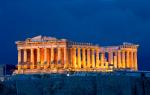
13.
View of Gibraltar and the Rock of Gibraltar 426 meters high. It is from the side of the Iberian Peninsula. In ancient times, the rock was known as one of the Pillars of Hercules, as evidenced by the monument in the southern part of the rock. "Pillars of Hercules" is the end of the world, the limit of the world))) but Hercules did not know geography well. According to one version, Hercules broke through the channel. And on the other hand, on the contrary, he narrowed it so that sea monsters would not penetrate the Mediterranean Sea.
14.
Not everyone knows that the dollar sign ( $ ) is a stylized image of the Pillars of Hercules entwined with the mythical serpent Python. According to Plato, mythical Atlantis located right behind the Pillars of Hercules. So maybe we passed over it ...)))
 The rock is also called Mount Tariq, Djebel al-Tarik, in honor of the Arab commander Tariq ibn Ziyad, from whose name Gibraltar was named. About 250 Barbary macaques live on the mountain in the upper part - the only species of wild primates in Europe. There is a reserve. People come to the rock to see the monkeys and the labyrinth of tunnels.
On the northern part of the rock stands the Jabal-at-Tariq fortress. The fortress was well fortified, and the Algerian pirates could not take it.
The unique feature of the rock is the system underground tunnels, whose length exceeds 50 km. In 1704, during the War of the Spanish Succession, English troops led by Admiral George Rook captured Gibraltar, after which the Treaty of Utrecht was signed in 1713, recognizing the peninsula as the possession of the English crown. Subsequently, the Spaniards tried many times to regain the peninsula by storming the fortress. In the fourteenth siege, called the Great Siege of Gibraltar and lasting from 1779 to 1783, the first tunnel was dug into the rock. The commander of the garrison, George Augustus Eliott, decided to fire on the Spanish batteries, standing on the plain in front of northern part rocks. A tunnel was dug to connect the Willis battery with a recess on the northern face of the rock (where it was planned to install the guns), which at first had no embrasures, but the ventilation holes were excellent for firing.
15.
The galleries that show tourists finished in 1797. The British dug 304 meters of tunnels and made several halls. The embrasures offer a unique view of the Gulf of Gibraltar, the isthmus and the territory of Spain.
16. .
.
The length of the strait is 65 km, the width is 14 - 44 km, the depth in the fairway is up to 338 m ( greatest depth 1181 m). In the Strait of Gibraltar, at different depths, the currents are directed in opposite directions.
17.
18.
19.
There are no waves, and the wind is very strong.
20.
21.
View from the last deck 12.
22.
23.
24.
25.
People got coats))
26.
The breeze even blows off your feet)))
27.
There are no waves, the wind blows the wave))
28.
29.
Vichka is saved by a plaid)))
30.
The wind pleased with freshness ... we are wet after the pool, but nothing)) It's good to have protective screens.
31.
32.
Two banks...
33.
I put the cap on my very ears, otherwise it blew off twice)) I almost flew away))
34.
35.
36.
37.
general information
The Strait of Gibraltar was known to ancient navigators who considered it geographic edge light, a kind of boundary between the surrounding and the unknown worlds.
Many believed that stumbling in these places, you can fall over the edge of the Earth. The Strait of Gibraltar, which gave rise to many legends and myths, connects the Atlantic with the Mediterranean, at the same time separating Africa and Europe. Located at the southern tip of the Pyrenees, it is only fourteen kilometers in its narrowest section, so that in this place you can simultaneously see the coasts of two continents. Its shores are mostly rocky: on the European side, these are monolithic limestone rocks, and on the African side, Mount Jebel Musa, located in Morocco. The ancients called these heights "the last points of the earth", and the Strait of Gibraltar itself was associated with a passage between the rocks. The Phoenicians called this place "The Pillars of Melkart", after their god of navigation, the Romans - "The Pillars of Hercules". According to Greek legends, The Strait of Gibraltar was crowned along the edges by two colossal pillars-columns, marking the transition to an unknown world.

Oceanography
In this place, as well as in the Bosporus, there is always a very strong current, due to the fact that the level of the Mediterranean is much lower than the Atlantic. Therefore, it receives the bulk of the water from the ocean through the Strait of Gibraltar, which, as a kind of threshold, prevents the penetration of cold deep waters into the sea, forming such a phenomenon as homothermy. The situation is complicated and strong winds which are not uncommon in these places. Over the entire period of its existence, the Strait of Gibraltar spontaneously closed and opened about eleven times. For example, six million years ago, its closure as a result of the movement of lithospheric plates led to an increase in salinity in the Mediterranean, forming a layer of evaporites 2 kilometers thick. And only its discovery after 0.7 million years somewhat "revived" this sea.

British Gibraltar
Until the 13th century, the territories around the strait on the European side were in the hands of the Arabs. It is connected with them modern name"Gibraltar", which gradually grew into the already familiar to us "Gibraltar". This is the name of both the strait and the fortress built on the shore. Today the city is positioned as English. Here is the military base of the Mediterranean forces of NATO. The capital of the rock state - the city of Gibraltar - is a mixture of two different cultures: Spanish and Mauritanian. This typical Mediterranean port with Victorian and Georgian buildings is offshore. The locals themselves call themselves Spanglish. The British presence in this place is reminded not only by the names of the streets, but also by the abundance of pubs, as well as the English uniform of the police and the name of the currency - the Gibraltar pound.

For Russian citizens, a visa to Gibraltar is issued at the British embassy or consular departments.
Moroccan Gibraltar
On the other side of the British Gibraltar is the territory of Morocco with its most significant settlement - the city of Tangier, which has at least interesting story than its neighbor across the strait. At first it was a territory controlled simultaneously by France, England and Spain, but after the Second World War, its French part passed to the Spaniards. However, after the end of the war, the Arab locals gradually began to express dissatisfaction with the presence of foreigners, and as a result, Tangier was annexed by the Moroccans in 1956. Today it is a fairly large port city, which connects the Strait of Gibraltar with Europe. It still remains Europeanized, as it is inhabited by Germans, British, Spaniards, Italians, French. There is even a small Russian community.
Strait of Gibraltar. To the left - Spain, to the right - Morocco.
The Strait of Gibraltar (Spanish Estrecho de Gibraltar, English the Strait of Gibraltar) is an international strait between the southern tip of the Iberian Peninsula and the northwestern coast of Africa, connecting the Mediterranean Sea with the Atlantic Ocean. Length 65 km, width 14-44 km, waterway depth up to 338 m (maximum depth 1181 m). (True length 59 km).
In the Strait of Gibraltar, at different depths, the current is directed in opposite directions. In the surface current directed to the Mediterranean Sea, an average of 55,198 km³ of Atlantic water flows per year ( average temperature 17 °C, salinity above 36‰). In the deep current directed to the Atlantic Ocean, 51,886 km³ of Mediterranean water flows (average temperature 13.5 ° C, salinity 38 ‰). The difference of 3312 km³ is mainly due to evaporation from the surface of the Mediterranean Sea. Along the shores of the Strait of Gibraltar are steep rock masses, which in ancient times were called the Pillars of Hercules - the Rock of Gibraltar in the north and Musa in the south.
Due to its convenient geographical position, the Strait of Gibraltar is of great economic and strategic importance, it is under the control of the English fortress and the naval base of Gibraltar. In the area of the strait are Spanish ports Ceuta, La Linea, Algeciras, as well as Moroccan Tangier.
For many years, Spain and Morocco have jointly studied the creation of a railway and/or road tunnel under the strait, similar to the one that connects France and Great Britain under the English Channel. In 2003, a new three-year research program was launched.
A group of American and British builders, for their part, considered building a bridge across the strait. Such a bridge was supposed to be the highest (over 900 meters) and the longest (15 km) existing in the world. Science fiction writer Arthur C. Clarke described such a bridge in his novel The Fountains of Paradise (1979).
Strait of Gibraltar regime
The Strait of Gibraltar is the most important route of communication between the Mediterranean powers and the Atlantic Ocean. The significance of this strait increased even more after the construction of the Suez Canal in 1869, when not only Mediterranean communication routes, but also routes to East Africa, India, China and the Far East.
The strait is convenient for swimming. Its length is about 90 km, width from 14.2 to 45 km, depth from 366 to 1180 m. The exceptionally great economic and strategic importance of the strait predetermined for many centuries the struggle between England, Spain and France for dominance and control over it. Only in 1704, as a result of a long war for the Spanish inheritance, England managed to capture the very strategically convenient peninsula of Gibraltar with an area of 5 square meters. km, on which a naval base and a fortress were then built.
Gibraltar is a massive rock up to 429 m high. The length of the rock is 4.5 km, the width is up to 1.4 km. A significant part of the fortifications is carved inside the rock and is well protected both from the air and from the sea. long time Gibraltar was one of the most important strongholds of English naval power.
With the appearance in the Mediterranean of the 6th American fleet, the former naval power of England in this area was actually lost. As a British colony, Gibraltar is governed by a British governor who is also commander of the colony's armed forces.
The regime of the strait from 1904 to 1907 was regulated by the bilateral "Treaty of Morocco" between England and France, to which Spain joined in 1907. The agreement provided that the strait was open for unhindered navigation of ships and vessels of all countries.
In 1907, England, France and Spain concluded a new agreement, which declared the demilitarization of the Strait of Gibraltar and confirmed the unlimited freedom of navigation for ships and ships of all countries. This principle was approved by the majority of states, and the strait was considered by all states as part of the high seas.
Currently, any ships and warships can pass through the strait without any restrictions. Even at its narrowest point, the strait is not completely blocked by the territorial waters of Spain and Morocco. As you know, Spain has 6-mile territorial waters. However, according to existing international rules, it does not have the right to distribute them beyond the median line of the strait.
The width of the territorial waters of Morocco is 3 miles. Therefore, in the narrowest part, south of the median line of the strait between the territorial waters of Spain and Morocco, there is a strip of high seas 1.2 to 2.5 miles wide, not blocked by the territorial waters of coastal states.
Based on the principles of modern international law on freedom of navigation on the high seas, enshrined in the Geneva Conventions of 1958, the claim of any state to a dominant position in the strait should be regarded as a gross violation of international law, since the strait connects huge open water basins, is of exceptionally great economic importance as the most important transport artery and is part of the high seas. In the interests of all mankind, the Strait of Gibraltar must always be free for the navigation of ships and vessels of all nations.
IN last years Spain insists on the return of Gibraltar, captured by England 260 years ago. In October 1964, the dispute between Spain and England was considered at the UN in a special Committee of 24. At the meeting of the Committee, the representative of the USSR made a proposal to liquidate military base NATO in Gibraltar and turn it into a demilitarized zone.