Geographic heritage of Asia
1 of 82
Presentation - Natural Heritage of Asia
The text of this presentation
Natural heritage of Asia
Geography course Grade 10 Berdyugina Victoria Nikolaevna, teacher of geography and biology, MBOU Sarasinsky secondary school of the Altai region of the Altai Territory s. Sarasa 2014

Japan
Yaku - Japanese island, 60 km south of the island Kyushu. It is an irregular pentagon with an area of 503 km². highest point- 1935 m above sea level. Most The islands are covered with tropical forest. The sugi tree is widespread. Rich fauna including deer and monkeys, picturesque mountains and waterfalls, thermal springs.


Shirakami-Santi (" mountain lands white god") - a mountain reserve that combines virgin deciduous (mainly beech) forests in the north of the Japanese island of Honshu with an area of 1300 square meters. km. Fishing and hunting in these protected forests possible only with the express permission of the authorities. In the forests of Honshu, you can find black bear, serau mountain goat and 87 species of birds.

Shiretoko is a peninsula in the east of the Japanese island of Hokkaido. The name of the peninsula comes from the language of the Ainu people and means "end of the earth. From the eastern tip of the peninsula, the island of Kunashir is clearly visible. It is one of the least populated and cultivated areas in Japan.

Bonin Islands or Ogasawara Islands - a group of more than 40 islands located between Mariana Islands and Japan. It is part of Tokyo.

Fujiyama, Fuji is an active stratovolcano on Japanese island Honshu is 90 kilometers southwest of Tokyo. The height of the mountain is 3776 m (the highest in Japan). Currently, the volcano is considered weakly active, last eruption was in 1707-1708. The mountain has an almost perfect conical shape and is considered sacred, serves as an object of tourism, as well as religious pilgrimage for Buddhist and Shinto cults. Fuji has been a popular subject in Japanese art for centuries. Today at the top of Fuji are located Shinto shrine, Postal office and weather station.


Türkiye
Goreme National Park - museum under open sky in Turkey. The national park covers an area of 300 km². The area of the park includes 6 churches and many monastic buildings.


Cappadocia ("Country beautiful horses») - historical name areas in the east of Asia Minor on the territory of modern Turkey, used from antiquity until the present day. Characterized by an extremely interesting landscape volcanic origin, underground cities, created in 1 thousand BC. e. and extensive cave monasteries, leading its history from the time of the early Christians.


Sri Lanka
Sinharaja - national park located in the southwestern part of Sri Lanka. It is the only tropical forest tree in the country. The landscape is a series of valleys and ridges. 60% of tree species are endemic and many of them are rare species. Inhabits many rare birds, butterflies, reptiles and mammals. Among them are the Indian elephant, leopard, Ceylon azure magpie, Ceylon starling, python. There are 21 species of endemic birds and several rare insects, reptiles and amphibians in the national park. The name of the park literally means "lion" (sinha) and "king" (raja).


Highlands of Central Sri Lanka - mountain forests in the south-central part of the island. Forests located at an altitude of up to 2500 meters above sea level are distinguished by high biological diversity and a high level of endemism.


Philippines
Tubbataha Reef - Protected Area and Marine natural Park part of the Philippines, located in the central part of the Sulu Sea. The marine and bird sanctuary consists of two large atolls (named North and South) and a reef. North Atoll is a nesting site for many species of birds and sea turtles(byss and greens). The park is an example of untouched coral reef with a 100-meter perpendicular coral wall, an extensive lagoon and two coral islands. It is the center of marine biodiversity; it is home to 75% of the described coral species and 40% of the world's reef fish. It is home to at least 600 fish species, 360 coral species, 11 shark species, 13 dolphin and whale species, and 100 bird species.


Puerto Princesa Underground River is a national park on about. Palawan. The park is located in the karst development zone. This river flows underground, in a cave, in the direction South China Sea. Its length is about 8 km. The cave has several large halls.


Thailand
Khao Yai is a national park. the first in the country, created on September 18, 1962. important role in its creation. It covers an area of 2.168 square kilometers, including evergreen forests and grasslands. Altitude ranges from 400 to 1000 m above sea level. There are 3,000 plant species, 320 bird species, and 67 mammal species in the park, including the Himalayan bear, Indian elephant, gaur, tigers, gibbons, Indian muntjac deer, and wild pigs. Numerous waterfalls.


Nepal
Chomolungma (Tib.), Everest (English), Sagarmatha (Nepalese) (8848 m) - highest peak Earth. Located in the Himalayas, in the Mahalangur-Himal range. The southern peak (8760 m) lies on the border of Nepal and the Tibetan autonomous region(China), the Northern (main) peak (8848 m) is located in China.


Sagarmatha National Park is located in the Himalayas in Nepal, northeast of the capital Kathmandu. The territory occupies 1148 km² of the ecological zone of the Himalayas. The park consists mainly of rugged rugged lands and gorges of the Upper Himalayas. The height of the territories ranges from 2845 m (Mongeo) to 8848 m (Mount Chomolungma) above sea level.

Chitwan National Park is a national park. It is located 200 km from the capital Kathmandu. Until 1973, the park was a favorite hunting ground for Nepalese kings. In 1973 it was declared a protected area, the first of national parks Nepal.

Mongolia
Ubsunur basin - the water basin of Lake Ubsu-Nur, the northernmost large closed water basin in Central Asia. The length of the Ubsunur basin from north to south is 160 km, and from west to east 600 km.

Malaysia
Kinabalu is the fourth highest mountain in South-East Asia, height - 4095 meters. A very young, in geological time scale, mountain. It continues to rise at a rate of about five millimeters per year. Built with granite. On the formation of relief big influence caused glaciation.


China
Huangshan ("Yellow Mountains") is a mountain range in Anhui Province in eastern China (about 300 kilometers southwest of Shanghai). The area is known for its granite cliffs covered with pine trees, praised by Chinese artists and poets.


Huanglong (“Yellow Dragon”) is a picturesque protected area, famous for its travertine terraces (from calcareous tuff), numerous lakes, of various colors and shapes. It is located in the highlands in the northwest of Sichuan province. The reserve is home to a number of rare animals such as the giant panda and the golden snub-nosed monkey.


National jiuzhaigou park("Valley of Nine Villages") - a nature reserve in the north of Sichuan province in central China. Known for its multi-level waterfalls and colored lakes.


Wulingyuan - part mountain system Wulingshan is located in the northwest of Hunan province in China. As a result of the weathering of sandstones and limestones, about 3000 peaks and cliffs of the most bizarre shapes were formed. They are separated deep gorges with rivers, lakes and waterfalls; there are two natural bridges and about 40 caves. The mountains are home to a number of endangered plant and animal species.


"Three Parallel Rivers" is a national park in China, located in the northwest of Yunnan province. On the territory of the park there are the upper reaches of three largest rivers Asia: Yangtze, Mekong and Salween, which flow in gorges up to 3,000 m deep. In this section, the rivers flow almost parallel from north to south. After turning the Yangtze to the north, it flows through the famous Leaping Tiger Gorge. It grows over 6,000 species, or about 20% of all rare and valuable plants in China. Also, more than 25% of all species of the PRC fauna live here.


Reserves giant panda- a complex of 7 reserves and 9 parks in Chinese province Sichuan. More than a third of the world's population of the rarest giant panda lives in the reserves, as well as the red panda, snow leopard and clouded leopard. In addition, 5-6 thousand plant species grow in the region.

South China Karst - located in southern provinces China. This area is known for its karst topography and biodiversity.

Mount Sanqingshan or Mount Sanqing is a mountain and a national park of the same name in the Chinese province of Jiangxi. The main attraction of the area are picturesque groups of granite rocks in the middle of a dense forest.


Kyrgyzstan
Sulaiman-Too - sacred mountain in Osh. It is a five-domed calcareous remnant, elongated from west to east. Its length is more than 1140 m, width - 560 m. Since ancient times it had a sacred meaning, as evidenced by the preserved petroglyphs. On the slope of the mountain there is a museum of its history.


Kazakhstan
Saryarka - Steppes and lakes of Northern Kazakhstan - the first natural object world heritage in Kazakhstan and Central Asia. The object consists of two nature reserves located in the steppe zone. The site includes two groups of fresh and salt water lakes, which are important stopping points for millions of migratory birds. These wetlands support populations of globally threatened species such as Siberian Crane, pink flamingo, white-tailed eagle, duck, curly pelican.


Yemen
Socotra is an archipelago from four islands and two rocks in Indian Ocean off the coast of Somalia, about 350 km south of Arabian Peninsula. Composed mainly of crystalline rocks. It is one of the world's most isolated archipelagos of continental origin.

Socotro's dragon tree

Indonesia
Komodo National Park is a national park. Founded in 1980 to protect the Komodo dragon, the largest lizard in the world, which can reach three meters or more in length and weigh over 70 kg. The lizard was first discovered by Van Stein in 1911. Komodo National Park has been selected as one of the New 7 Wonders of Nature.


Lorenz is a national park in the Indonesian province of Papua. Is the biggest protected area in Southeast Asia.

Virgin wet- rainforests Sumatra is a tropical rainforest on the island of Sumatra with an area of 2.5 million hectares, which is under threat. Due to the risk posed by poaching, illegal logging, agricultural encroachment and road construction plans through the site, the forests have been inscribed on the World Heritage List.


India
Kaziranga National Park - founded in 1905. The park has beautiful tropical forests, rivers, magnificent meadows. It is home to the world's largest population of one-horned rhinoceros. In total, there are more than 30 species of mammals in the park, 15 of which are endangered in the world.


Keoladeo is a national park. The park is home to many rare and endangered bird species that migrate here in winter period. It is of interest to both tourists and ornithologists.
Indian beaks

The Manas National Park is home to a rare species of golden langur and a significant population of tigers. It has a rich and varied avifauna. Its main attraction is a large hornbill.
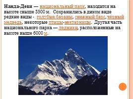
Nanda Devi is a national park located at an altitude of over 3500 m. Rare species have survived in the wild - blue sheep, snow leopard, black bear, some sunbirds. Other part national park- glaciers located at an altitude above 6000 m.

One of the attractions of the park - Skeleton Lake - a small alpine glacial lake in the Himalayas.

Valley of Flowers is a national park located in the Western Himalayas high in the mountains, famous for its meadows with flowers of extraordinary beauty.

Vietnam
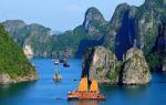
Halong Bay ("where the dragon descended into the sea") - includes more than 3,000 islands, as well as small rocks, cliffs and caves. Both ground and undersea world characterized by high biodiversity. According to legend, Ha Long Island was created by a large dragon. He always lived in the mountains, but when he went out, he hollowed out valleys and hollows of various shapes with his tail. After he plunged into the sea, the places dug out by his tail filled with water, and only small islands of land remained. locals and to this day they say that a dragon lives in the bay.
Code to embed presentation video player on your site:


 Back forward
Attention! The slide preview is for informational purposes only and may not represent the full extent of the presentation. If you are interested in this work, please download the full version.
Goals:
- Help students to understand the social significance of the material that they have collected to create a project in the form of presentations
- Create conditions for:
- application in research work of previously acquired knowledge, skills and abilities on the topic "World Natural and Cultural Historical Heritage";
- stimulating interest in research work by presenting the collected material for public familiarization;
- instilling love, respect, interest, respect for the world around;
- development of skills to work with the atlas, the text of the textbook, additional literature, INTERNET resources, wall maps, multimedia installation, computer;
- mastering knowledge on the topic "Asia: Natural and Cultural Historical Heritage"
- further development of media skills;
- acquiring the skills to create an interesting presentation with an expression of one's attitude to work;
- acquisition of skills and abilities to create an image natural and cultural historical heritage of any region of the world;
- systematization and synthesis of the material.
Conduct form: project protection.
Equipment:
- physical map of Eurasia,
- presentations:
« Asia: natural and cultural historical heritage. Part 1",
« Asia: natural and cultural historical heritage. Part 2",
« Asia: natural and cultural historical heritage. Part 3",
« Asia: natural and cultural historical heritage. Part 4",
« Asia: natural and cultural historical heritage. Part 5"
Literature:
- Large Atlas of the World "Globe", Asia / Per. with him. - M: LLC "TD" Publishing House World of Books ", 2006. - 80 p.
Lesson structure
- Organizing time.
- Stage of acquaintance with the topic of the project, joint setting of project goals.
- Stage of work on the main part of the project.
- Stage of debriefing of the project.
Lesson progress
I.Organizing time.
Lead project defense:
Dear friends, guests! We are glad to see you today on our project. I really want you to get a new, interesting, necessary amount of knowledge today that would have social significance for you and help you expand your cognitive horizons.
The project is attended by students of the 7th grade - the direct defenders of the project and students of the 11th grade (10 people), who participate in the blitz rating to identify the best projects and the best researcher.
II. Stage of acquaintance with the topic of the project, joint setting of project goals.
Lead project defense:
Today we are defending a project prepared by 7th grade students "Asia: Natural and Cultural Historical Heritage".
Research work on the project "World natural and cultural historical heritage" in parallel, the 7th grade is conducted throughout the school year. Already passed the protection of Africa, South America, Australia and Oceania.
Among the invited students are 11th graders, who also conduct research work on the countries of the world, making presentations about them on various topics: characteristics of the political system, economy, recreation and tourism, population, etc.
Before proceeding to the direct defense of the project, we will find out what goals the researchers and defenders of the project set themselves during the research work on the topic "Asia: natural and cultural historical heritage"?
Sample answers:
- Acquaintance with various latest sources of information (monographs of geographers - scientists, encyclopedias, the ability to find the necessary material on the INTERNET,
- Be able to select the necessary material on the topic, arrange it.
- Learn to synthesize information on a topic for a deeper understanding and development of a holistic view of it
- Learn to use the latest ICT in project implementation.
Lead project defense:
Dear invited students of grades 11 and students of grades 7 who are not participating in the defense of the project, we ask you to become members of the expert group. After viewing the projects, you must vote for the group of researchers whose presentation of the work you liked best. To do this, you have cards on the tables on which you need to write the number of the group in the order of performance.
III . Stage of work on the main part of the project.
Presentation of projects in the form of presentations, followed by questions from the members of the expert group.
Project manager - student 7 "B" Polyansky Vladimir:
In the course "Geography is our home Earth" - grade 7 - on all continents we study the topic " The division of the mainland into natural, natural-economic and historical-cultural regions.
For a more complete and in-depth acquaintance with this topic, we use the series “Great Atlas of the World. GLOBUS”, “Geography - children's encyclopedia”, INTERNET resources, “I know the world”, on which we create presentations for this project.
The main idea that runs through the red line when viewing the Asia presentations of parts 1-5 is as follows: "Asia is the largest continent on the planet. It was in Asia that the first cities in the world were founded, writing was invented, and the origins of all world religions are located here , cultural and historical monuments of different peoples are presented.“The roof of the world”, the Land of the dawn, “golden Bengal” - this is all unique Asia.” And so, on the way to the unique and amazing places of Asia.
1. Presentation of the presentation by group No. 1 "Middle East"
Asia: natural and cultural historical heritage. Part 1".
Team leader: In our presentation, a brief description of the history of Asia is given in illustrations, starting with the warriors of the clay army of the emperor of the whole Celestial Empire, Shi-Huangdi. We will talk about the holy city of Jerusalem, Persepolis - the city of the symbol of power of the first Persian kingdom of the Achaemenids, Mecca - the birthplace of Mohammed and much more from the natural and cultural historical heritage of the countries of the Middle East or Asia Minor.
(Showing a presentation Asia: natural and cultural heritage (part 1) ).
Lead project defense:
(For example:
- What source of information did you use in your work?
- What difficulties did you encounter in preparing the presentation?
- Did you use the INTERNET?
- Which countries are in the Middle East?
2. Presentation of the presentation by group No. 2 "Faces of Asia"
).
Team leader: In our work, we will talk about the people of Asia. More than half of its population lives on the largest part of the Earth. Ethnic diversity and traditions that have existed for centuries reflect the unique face of Asia. The deserted deserts and steppes of the Arabian Peninsula and Central Asia are opposed by cities with a million inhabitants in the east and southeast of the continent - in India, China or Japan. Hundreds of ethnic groups, countless languages and dialects, as well as various traditions and customs leave their mark on the appearance of this vast part of the Earth.
(Showing a presentation Asia: natural and cultural heritage (part 2) ).
Lead project defense: Dear members of the expert group, ask your questions about the project.
(For example:
- How many people live in Asia?
- What encyclopedia did you use when collecting material?
- What ethnic groups live in Asia?
3. Presentation of the presentation by group No. 3 "Religions of Asia"
.
Team leader: Golden temples, imposing pagodas, impressive rock shrines, proud minarets and magnificent mosques - nowhere is there such a diverse and religious life as in Asia. The giant continent is the cradle of the great world religions.
Judaism, Christianity and Islam, Hinduism or Brahmanism, Buddhism or Chinese and Japanese religions such as Taoism and Shinto, all have their origins in various parts of Asia and spread through trade routes throughout the continent and far beyond. For people living between the Arabian Peninsula and Japan, the diversity of forms of religion remains the main component of culture and life. This is evidenced by the grandiose buildings and temple complexes - the centers of ancient, at the same time, living traditions, as well as numerous holidays. They are both a place of vast knowledge and a place of deep reverence.
Presentation is shown Asia: natural and cultural heritage (part 3) .
Lead project defense: Dear members of the expert group, ask your questions about the project.
(For example:
- What types of religions are practiced in China?
- What are the national religions?
- What religious temples can you name?)
4. Presentation of the presentation by group No. 4 "Central and East Asia"
Asia: natural and cultural heritage (part 3) .
Team leader: The highest mountains in the world are the Himalayas, the wettest place in the world is the village of Cherrapunji, the longest construction by human hands is the Great Wall of China, which is visible from space. The fastest growing Chinese city of Shanghai, one of the tallest TV towers in the world in the Pudong district in Shanghai, a stadium in Pyongyang that can accommodate 100,000 people, a 3.4-meter-high granite sculpture of a seated Buddha in the cave temple of Seokguram in South Korea - this is all Central and East Asia .
Presentation is shown Asia: natural and cultural heritage (part 4) .
Lead project defense: Dear members of the expert group, ask your questions about the project.
(For example:
- Can you show the Himalayas on the map?
- Which country has the wettest place in the world?
- What computer program is used for the presentation?
5. Presentation of the presentation by group No. 5 "Land of the Rising Sun and Southeast Asia"
Asia: natural and cultural heritage (part 3) .
Team leader: Unique cultural and historical monuments and amazing landscapes in Japan can be found everywhere. The capital city of Tokyo and the metropolis of Osaka are considered centers of tourism. Osaka is the starting point for excursions to the ancient city of Kyoto, home to countless Buddhist and Shinto buildings. Southeast Asia is the "golden triangle" where the borders of Myanmar, Thailand and Laos converge - for a long time one of the most "opium" territories. The drug trade finances the fight against the military regime in Myanmar.
The Asian region is in crisis. Predatory capitalism, with its ruthless exploitation of man and nature and risky investments, is devouring its own children. The once booming national economy survives on foreign loans.
Presentation is shown Asia: natural and cultural heritage (part 5) .
Lead project defense: Dear members of the expert group, ask your questions about the project.
(For example:
- What is the name of the Japanese volcano located above Lake Kawaguchi?
- Which countries are called the "Asian Tigers"?
- What is the main food of Southeast Asians?
Lead project defense:
It's time to take stock of the defense of the project. I ask the members of the expert group to make their choice.
(On the card, the members of the expert group enter the numbers of the best groups that made presentations and the names of the researchers who answered the questions better and hand them over to the assistant presenter for counting votes);
- during the counting of votes, members of the expert group express their attitude to the event.
- summing up the results of the blitz rating and awarding the winners.
IV. The stage of summarizing the creation of the project
Lead project defense:
The work on creating a project does not end there, because. we want to know about the world, if not everything, then as much as possible, and this will require the continuation of research work from the next academic year on the topic “Knowledge of Russia”.
The name "Asia" (of Assyrian origin) indicates its geographical position and in translation means - the east. Unlike Europe, the Asian continent is extremely diverse. "Little" Europe is united by traditions and "cemented" by Christian values. Asia's past is more complex and has been shaped by various civilizations.
In the early 80s. one of the Indian historians said: "Take away Asia from the people, and they will lose their past, present and future." It is undeniable that the role of Asia in the world is unique. On its boundless expanses, ancient civilizations with a high material and spiritual culture arose. Their features still largely determine the economic profile and the specifics of the population.
Of the four great "river" civilizations, three were formed in Asia, in the valleys of the largest rivers of China, India and Mesopotamia. The first two were called "rice" civilizations. A special type of economy has developed here, which is characterized by high labor intensity and extensive development of irrigation. This type of farming required a large number of laborers, but at the same time, high-yielding rice could feed many more people than any other crop. Therefore, the valleys of the great Chinese and Indian rivers have become areas of the highest concentration of population in the world.
In Asia, centers of modern spiritual culture have developed on the basis of religious and moral and ethical teachings. Usually in Asia there are three main "cultural worlds" - Indian, Chinese and Arab-Islamic.
In the VI-V centuries. BC e. Buddhism arose in the north of the South Asian subregion, spreading widely to the east and north. In the first millennium, Hinduism developed on the basis of Buddhism, in the 16th century. - Lamaism. Buddhism had a huge influence on the formation of Chinese and Japanese religions and moral and ethical teachings - Taoism, Confucianism and Shintoism.
At the turn of the two eras in Southwest Asia, in Palestine, two more religious movements arose - Judaism and Christianity. Christianity gradually crossed the Asian borders and spread throughout the world. The same thing happened with Judaism. Currently, there are twice as many adherents of this religion in Europe and North America as in Israel.
In the vastness of Arabia in the VI-VII centuries. n. e. Islam arose, which is now widespread outside Southwest Asia - in the north and east of Africa, in South and Southeast Asia.
Features of the religious composition of the population of Asian countries are shown in Table 36. In Asia, most of all countries (16, or 1/3 of their total number), where Sunni Islam predominates. Buddhism dominates in six countries. Buddhism, Taoism and Confucianism are also combined in six countries.
The richest experience of the inhabitants in the struggle for survival in difficult natural conditions belongs to the geographical heritage of ancient civilizations. Most of the region is occupied by mountains, taiga and other inconvenient territories.
In Asia, classical types of terraced farming on mountain slopes have developed (in Japan, China, Southeast and South Asia). It is in Asian countries that irrigation has received the greatest development. In terms of irrigated area, Asia is far ahead of all other regions of the world, and China and India are ranked first and second in this indicator in the world.
A special type of agriculture is characteristic of monsoon regions, where moisture changes dramatically. Depending on the season of the year, a person struggles with excess moisture (creating protective dams on rivers) or with its lack (constructing irrigation systems).
Life in the difficult natural conditions of Asia has formed a special attitude towards work in the culture of the peoples. Amazing industriousness and the highest discipline are characteristic features of an Asian person.
The diversity of the population (see also the article ""), its cultural and everyday traditions is also evidenced by the diversity of types of nutrition of the inhabitants of Asia. Of the 20 types of food that exist in the world, 11 are represented in Asia, 8 in America, 5 in Africa, and 2 in Europe.
) were found in a rocky gorge in the southeast of the low Chu-Ili mountains, 170 km northwest of Alma-Ata. The cultural landscape of Tamgaly is known not only for petroglyphs, but also for ancient settlements, burial grounds, ancient quarries and places of worship. All of them were built starting from the XIV-XIII centuries. BC, and up to the beginning of the twentieth century. Artists of rock paintings skillfully used the phenomenon of "desert tan": the drawings were embossed with hard stones (most likely quartz), and later with metal tools on porphyrites - a durable rock that forms even planes when weathered. After applying the drawings, a brown crust appeared on them from oxides of iron and manganese. In total, there are about five thousand petroglyphs in this area. Among them you can see images of divine sun-headed creatures, “dancing men”, riders on horseback, bull-drawn chariots, hunting scenes, sacrifices, etc.
The proximity of the architecture of the various peoples of Central Asia is due to the unity of natural and climatic conditions, historical and ethnic community. The main building materials here were clay and raw bricks. The residential building of Central Asia has all the characteristic features of a southern dwelling: the isolation of the estate, the minimum number of openings facing the street; the premises are grouped around a small courtyard. In the "male" half of the house, the owner receives guests, conducts business, works in the workshop. Sleeping and utility rooms are concentrated in the "female" half. The peculiarity of the houses is aivans in front of the living quarters, which give a deep shadow, and thick walls made of mud bricks.
The conquests of Alexander the Great introduced elements of Hellenistic culture into Central Asia. By the middle of the III century. BC. two states were formed on this territory - Parthian and Greco-Bactrian. From the Greco-Bactrian period, only fragments of buildings with signs of ancient Mediterranean culture have been preserved. The legacy of the Parthian kingdom has been noticeably better preserved, because. its ancient capital Nisa was not far from Ashgabat, near the village of Bagir (Turkmenistan). During the excavations of Nisa, walls, towers, palace and religious buildings were discovered.
(Turkmenistan) were built in the III century. BC, when the territory of the modern was part of the Parthian kingdom. In his capital, the city of Nisa, a fortress was built, which was the royal residence. In Old Nisa there were palace and temple buildings, a treasury, warehouses and a wine storage. Its fortress walls, 8-9 meters thick, were fortified with 43 rectangular towers. At the beginning of the III century. The Parthian kingdom ceased to exist, and Old Nisa perished with it. Now, in its place, a mound has formed, having the shape of an irregular pentagon. Nearby is another mound - the remains of New Nisa. The fortresses of the Parthian kingdom in Nisa served as a kind of barrier that limited Roman expansion to the east.
In the I-IV centuries. in the southern part of Central Asia there was a Kushan kingdom with a center in the modern region. The flourishing of the Kushan culture bizarrely combined Hellenism, in particular, ancient order systems, with the Buddhist tradition. At the same time, during the Kushan period, a powerful stream of another culture rushed to Central Asia - Indian, because. in the I-III centuries. the northern kingdom was also part of the Kushan kingdom.
![]()