Sea route to India (Portuguese sailors). Portuguese geographical discoveries
After the Normans, the Portuguese were the first of the peoples medieval Europe came to the expanses of the "Ocean Sea", as the Atlantic was called in antiquity. From the very beginning of the 15th century, they consistently overcame the many difficulties of sailing in the ocean.
Prince Enrique (1394-1460) played an important role in the development of navigation in Portugal. Later, in the 19th century, he was named Henry the Navigator, although he himself never sailed. The prince believed that no matter how huge the African continent is, it ends somewhere. Therefore, in order to go around it, it is necessary to build good ships and supply from accurate maps and navigational instruments. In 1418, Henry the Navigator built an observatory and a shipyard on the southwestern coast of Portugal in Sagris, and also founded a nautical school where geographers, cartographers, mathematicians and astronomers taught Portuguese sailors.
The merits of Henry the Navigator are marked not only by monuments, but also by coins. In 1960, in memory of the 500th anniversary of his death, a series of silver coins with his portrait was issued in Portugal.
In 1987, the Mint of Portugal announced a long-term program (1987-2001) of issuing commemorative coins "Golden Era of Portuguese Discoveries" in honor of the achievements and discoveries of Portuguese navigators of the 15th-16th centuries. These 100 escudo coins were issued in an annual series of cupro-nickel and precious metals.
The first series, released in 1987-1988. consists of 4 coins dedicated to the 400th anniversary of the discovery of the Cape Good Hope. These coins marked the voyages of Portuguese sailors along west coast Africa, which eventually led to the opening of a sea route to the Indian Ocean.
On the obverse side of each of the coins is depicted the coat of arms of Portugal from different periods. On the reverse side of the three coins, a ship of the voyage is depicted.
Eanesh lived. Cape Bogador
The first coin of the series is dedicated to one of the turning points in the history of navigation - the sea voyage of Gil Eanesha beyond Cape Bogador on the west coast of Africa. It is depicted on the reverse of the coin to the right of the ship. Medieval Europe believed that Cape Bogador was the edge of the world.
Captain Gil Eanesh was an able student and squire of Prince Henry. In 1433, he tried to go around Cape Bogador, but his team rebelled, and he was forced to turn the ship towards home, reaching only the Canary Islands. A year later, Eanesh tried again and successfully rounded the cape, thus starting the era of great geographical discoveries.
Nunu Tristan
The second coin of the series is dedicated to the navigator and slave trader Nun Trishtan, who was also at the court of Henry. Trishtan discovered the mouth of the Gambia River after Eanesh passed south along Africa. The reverse side of the coin depicts Trishtan's ship and a group of islands to the right of it, which were also discovered by him.

Diogo Kahn
The next of the famous Portuguese captains was Diogo Can. The third coin of the series is dedicated to him. In 1482-86. he made 3 voyages south of the equator, during which he discovered and mapped 1450 miles of the western coast of Africa, reaching the Cape of the Holy Cross. Diogo Kahn was well versed in navigating the stars, which is why the coin dedicated to him depicts a compass and an astrolabe.

On the reverse side, to the right of the ship, there is a relief map of the southwestern part of Europe and the western coast of Africa. On the African coast, you can see three stone pillars - Diogo installed such pillars with a cross and the royal coat of arms as a sign of the annexation of new lands "for the glory of God and the king" to Portugal. On the circumference of the coin, divisions are applied like a compass, and the coordinates corresponding to the mouth of the Congo River, Cape St. Mary and Cape Holy Cross are marked with numbers.
Bartolomeu Dias de Novais
Diogo Cana's voyages were continued by the Portuguese navigator Bartolomeu Dias de Novais. In 1487 he was appointed head of an expedition to discover new lands south of Cape Holy Cross. After a voyage of 16 months and a length of 16,000, Bartolomeu's ships returned to Lisbon with great news - they were in the Indian Ocean and dug new cape, which was called the Cape of Storms, and the king later renamed it the Cape of Good Hope, because with this discovery, Portugal's chances of reaching the shores of India increased. Later based on the report of Bartolomeu Another great navigator Vasco da Gama developed a sailing route to India in 1497-99.
The coin dedicated to Bartolomeu depicts the outlines of the African continent and the Cape of Good Hope is marked with a cross. Two identical sailboats on both sides of the continent symbolize a successful journey to southern Africa and further along the coast.

Simultaneously with voyages along the coast of Africa, Portuguese navigators began to study the waters of the Atlantic. More on this in the second part of the article.
100 great geographical discoveries Balandin Rudolf Konstantinovich
SEA ROUTE TO INDIA ( Portuguese sailors)
SEA ROUTE TO INDIA
(Portuguese sailors)
Theoretically, the route from Portugal to India around Africa was opened already at the end of the life of Henry the Navigator. Documentary evidence of this has been preserved: a map of the world larger than human height. It was compiled in the monastery of Murano near Venice, and it was called the Great Venetian, or Fra Mauro map. It depicts Europe, Asia and Africa; the ocean extends around the entire inhabited land, and it is possible to reach India from Western Europe, rounding Africa.
Of course, the map travel only mentally. However, in true geographical discoveries, thought precedes deeds. The large Venetian map clearly showed that the implementation of the eastern sea route from Europe to India requires only time, money, perseverance and a bit of luck.
Here it is appropriate to recall the saying: overseas a heifer is a half, but a ruble is transported. No matter how cheap precious spices are in India, it turned out that the tempting path was too far. Wouldn't it be easier to trade through intermediaries on the already beaten caravan, river and sea routes through the Mediterranean and Black Seas?
Such doubts of the Portuguese were quite reasonable. However, quite unexpectedly, their commercial and political competitors, the Spaniards, had their say. They decided to get to the east, sending their ships in the opposite direction - to the west! And they quickly achieved success (not realizing that they did not reach Asia).
But why did the Portuguese march for almost a century east way to India, abandoning the search for the Western way?
An essential role was played by the fact that Henry the Navigator and his successors used maps that depicted a round Earth and, naturally, a flat one (it is a difficult task to depict the surface of a ball on a flat sheet). And what is there, on the other half of the globe, except for the desert ocean? There was no reliable data on the real size of our planet at that time.
... After Cape Bojador, the southern tip of Africa became a critical frontier for Portuguese sailors. The main natural obstacles were the Benguela Current, storms and southeast trade winds. For light ships under sail, it was not easy to overcome these obstacles. Once upon a time, a flotilla equipped by Pharaoh Necho chose the path - by chance - the most convenient way to go around Africa: clockwise. If you move in the opposite direction along the coast, then in the west you meet the resistance of a warm current. It runs northward between the Cape Verde Islands and the mainland. True, then swimming is favored by a large warm Guinean current, washing from the northwest to the southeast and then to the south, the shores of the bay of the same name. Sailboats can go this way quite quickly. But behind Cape St. Martin (at the latitude of St. Helena), a branch of the cold and powerful Benguela Current moves north along the continent.
For this reason, the easiest, most convenient and fastest route from the northwestern tip of Africa to the southern tip does not lie in a straight line and does not run along the coast, but is directed through Atlantic Ocean, to the southwest, then - along the Brazilian current to the south and, finally, to the east. (Approximately such a course was chosen by Vasco da Gama). This is how the principle of space-time relativity manifests itself in geography: movement in the direction of the prevailing winds and currents of the World Ocean passes faster than along more shortcut but against atmospheric and sea currents.
This example clearly shows how important knowledge was in the history of navigation. natural conditions, in the first place - the direction and strength of air and water masses. Not surprisingly, such information was kept strictly secret.
So, the discovery by the Portuguese of the sea route from Western Europe to South Asia lasted ... 85 years. Its beginning is usually considered the capture of Ceuta in 1415, and the end is the autumn of 1499, when Vasco da Gama returned to Lisbon after visiting India.
The first half of this discovery was completed in 1462, two years after the death of Prince Henry, when his sailors entered the Gulf of Guinea. Regular expeditions in this direction began only in 1470. After 5 years, it was possible to move to the Southern Hemisphere, however, only two degrees, to Cape St. Catherine.
The next two expeditions were led in 1482 by Diogo Can. In four years, he was the first European to delve more than 20 degrees into the southern hemisphere, having explored one and a half thousand miles. African coast up to the Namib Desert.
A significant thrust to the south was made by the skilful navigator Bartolomeu Dias (Bartolomew Dias). His flotilla (of three small ships) left Lisbon in 1487, began to explore the shores south of the mouth of the Congo River (Zaire) and went south further than Diogo Cana along the desert lands, passing the zone of the Southern Tropic. A strong oncoming current and a storm forced Dias to deviate to the west, towards the open ocean.
They were carried far to the south of the continent's outskirts (this, of course, they could not know). Although it was summer in the Southern Hemisphere (January 1488), it was getting colder. Their ships were not adapted for sailing in cold seas, the crew did not have proper clothing. The sailors were most afraid not even of a storm, but of death from the cold. Finally, the storm subsided, warmer. Dias headed east. For several days they could not see the land. Diash rightly decided that they rounded the outskirts of the mainland, and turned the ships to the north.
Only on February 3 did they manage to reach the shore. Several half-naked shepherds were grazing cows in the meadow. Seeing the strangers, the natives began to shout and wave their hands. With a shot from a crossbow, the Portuguese killed one of them, the rest fled.
Having named the bay Shepherd and having collected fresh water, the Portuguese headed east. However, the team began to grumble, tired of the difficult voyage, demanded to return to their homeland. Dias begged to wait another three days. The coast turned gently to the northeast. Dias was sure that now the way to India was open. Alas, in order to avoid a rebellion of the team, the captain was forced to give the order to turn back. The only consolation to him was the hoisted by his expedition stone pillar(padran) with a cross on the farthest point of the African coast for Europeans.
According to the 16th-century Portuguese historian João Barros, Dias “felt such a feeling of bitterness, such grief, as if parting with his beloved son, doomed to eternal exile; he recalled the danger with which both for himself and for all his subordinates he went such a long way only to put up this stone pillar, and God did not let him do the most important thing.
Having passed a cape in southern Africa, around which they fell into a strong storm, the Portuguese called it Tormentosu ("Stormy"). But when Dias, returning to Lisbon, reported his expedition to King Juan II, he decided that there was no need to disturb the navigators in advance, who now had a way to India, and renamed Stormy into the Cape of Good Hope.
However, there was little hope of reaching India by this route: it turned out to be too difficult and long. The King of Portugal did not rush to send a new expedition. He was forced to do so only by changed circumstances.
In March 1493, Christopher Columbus returned to Spain, announcing his discovery of the islands of Asia across the Atlantic Ocean (for which he took the islands of the Caribbean). Pope Alexander VI (“the most perfect incarnation of the devil on Earth,” according to Stendhal) by his decree divided the world across the Atlantic Ocean in such a way that Portugal got the lands south of the equator, and Spain - to the north ...
For the Portuguese, it became clear: it was necessary to master the eastern route to India. In 1497, a new expedition was organized with the aim of circumnavigating Africa and reaching the coveted (for merchants) India. The new king, Manuel I, appointed the noble courtier Vasco da Gama as its head. This enterprise was considered honorable and responsible, but extremely difficult and associated with possible hostilities. Vasco da Gama, five years earlier, showed his resourcefulness, courage and determination in the fight against French privateers (pirates in public service). Perhaps this is what the king remembered when he determined the head of the expedition - more military and commercial than consistent. In addition, an authoritative diplomat was required in case it happened to conclude trade and political agreements with the rulers of Asian countries. Vasco da Gama was not an experienced sailor. In all other respects, his candidacy was quite suitable. And excellent captains and navigators, of which there were many in the country, could lead the ships.
In July 1497, Vasco da Gama's flotilla (four large ships) went to the ocean. They headed south and, passing the Cape Verde Islands, instead of entering the Gulf of Guinea, began to go around it from the west, moving further and further away from the mainland. This made it possible, approaching the latitude of the Cape of Good Hope and using the currents, to turn to the east, relatively easily and quickly reaching the southern tip of Africa.
In Shepherd's Harbor, Vasco da Gama made a peaceful bargain with the natives, receiving a fat bull and ivory bracelets in exchange for red caps and bells. Moving further to the north-northeast, the Portuguese met more and more civilized tribes who mastered agriculture and metallurgy, and established trade relations with the Arabs.
In the Zambezi Delta, the Portuguese were forced to stop for a month to repair ships. Many of the sailors were seriously ill with scurvy, and several died. Scurvy was one of the terrible enemies of sailors until the second half of the 18th century, or rather, not the disease itself, but ignorance of its causes and measures to combat it. Even among the lush tropical vegetation, Europeans often died from this disease, never realizing that there were cures for it around - nutritious plants containing vitamin C.
Going further north, the Portuguese increasingly met the ships of Arab merchants, who exported slaves, ivory, ambergris, and gold from these areas. Realizing that the Europeans were their competitors, the Arabs did everything possible to make it difficult for them to navigate. In the large port of Mombasa, located near the equator, it came to an armed conflict. Vasco da Gama showed determination and cruelty, ordering the torture of prisoners and capturing merchant ships like a real pirate.
At the next stop in the harbor of Malindi, Vasco da Gama was friendly met by a local sheikh (who was at enmity with Mombasa) and gave them an experienced Arab pilot Ahmed Ibn Majid, an expert on navigation. He ordered to take a course to the northeast, into the open ocean. With a favorable monsoon and sea currents, they quickly reached the coast of India and on May 20, 1498, stood in the roadstead near the large city of Calicut (not to be confused with Calcutta, located on opposite side peninsulas of Hindustan). True, their business did not go very well. Almost all foreign trade in Calicut was controlled by the Arabs. (They greeted the aliens with the words: "What devil brought you here?")
Nevertheless, Europeans managed to acquire spices, precious stones, silk fabrics. Unable to pay customs fees, Vasco da Gama seized noble hostages (also a common pirate trick) and exchanged some of them for Portuguese sailors captured in the port and his cargo detained at customs.
The return journey to Lisbon was completed without much incident. In the summer of 1499 the expedition ended. Only two ships and less than half of the sailors returned. Delivered goods fully paid off the costs of the enterprise and even brought some income.
They rejoiced in the royal palace: the eastern sea route to India was finally opened, promising the flourishing of trade and the enrichment of the country and its rulers. Vasco da Gama received honors and congratulations.
And in the modest homes of the sailors who died in the voyage, sorrow reigned. No one glorified nameless young people who did not return to their homeland. “But they were the backbone of the expedition ... - correctly noted the American historian G. Hart. “They, along with Vasco da Gama, are also heroes of the opening of the sea route to India.”
From the book of 100 great geographical discoveries author Balandin Rudolf KonstantinovichTHE FURTHER VOYAGE OF THE MIDDLE AGES (Chinese sailors) Europeans had the most vague ideas about the eastern outskirts of the greatest continent, Eurasia, even in the late Middle Ages. The limited knowledge was reflected in the maps, where Asia Minor was depicted exorbitantly.
From the book Big Soviet Encyclopedia(CO) author TSBFROM ASIA TO AMERICA (Russian navigators) Peter I in 1724 ordered to find out “whether the Asian continent is connected to America.” An experienced navigator, a native of Denmark, Vitus Bering, was appointed head of the expedition, and his assistant was Lieutenant Alexei Ilyich Chirikov. Way on
From the book Great Soviet Encyclopedia (CE) of the author TSB From the book Siberia. Guide author Yudin Alexander Vasilievich From the book All masterpieces of world literature in brief. Plots and characters. Foreign Literature of the 17th-18th Centuries the author Novikov V IThe Northern Sea Route The Northern Sea Route (NSR) is the most important national transport route linking the Far East and western regions of the Russian Federation and uniting the largest river arteries of Siberia into a single system. Its length from the Karsky
From the book Blatnoy Telegraph. prison archives author Kuchinsky Alexander VladimirovichPortuguese letters (Les Lettres portugaises) Tale (1669) A lyrical tragedy of unrequited love: five letters from the unfortunate Portuguese nun Mariana, addressed to the French officer who abandoned her. Mariana takes up the pen when the sharp pain of separation from her lover subsides and
From the book Lisbon. Guide author Bergmann JürgenSection IV Road to India
From the book Swearing in 15 Languages [Pocket Phrasebook] author Turin Alexey AlekseevichPortuguese wines In Europe, vinhos maduros, the table wines of Portugal, are almost unknown - with the exception of port wine. And in vain: these are good, "correct" wines produced without chemical and other additives. The alcohol content in them is on average 9-13%, this
From the book I know the world. Great Journeys author Markin Vyacheslav AlekseevichПОРТУГАЛЬСКИЕ РУГАТЕЛЬСТВА BastardoбастАрдуублюдокBol?oбалАнужирдяй, толстожопыйBurro que nem uma portaбУрро кэ нэм ума пОртатупой как валенок (дословно: тупой, как дверь)CabraкАбрасука, стерваCaceteкасЭтеx..CaralhoкарАлъоx..Chupa meu pau!шУпа мЭупАу!отсоси у меня!Coma a merda e morra! coma a merde e
From the book Geographical discoveries author Khvorostukhina Svetlana AlexandrovnaOver the three seas to India "Journey over three seas" - this is the name of the notes of the Tver merchant Athanasius Nikitin, who visited India in 1468-1474. “I swam down the Volga. And he came to the Kalyazinsky monastery. From Kalyazin I sailed to Uglich, and from Uglich they let me go without any obstacles. And sail away
From the book Lisbon: nine circles of hell, the Flying Portuguese and ... port wine author Rosenberg Alexander N.Sea route to India. How it all began ... Modern scientists believe that the path from the Iberian Peninsula to India was discovered at the beginning of the 15th century. And the proof of this is a huge, almost human-sized, physical map of the world, the compilers of which were
From the book Thoughts, aphorisms, quotes. Business, career, management author Dushenko Konstantin Vasilievich From the book Basic Special Forces Training [ extreme survival] author Ardashev Alexey Nikolaevich From book Complete guide on methods, principles and skills of personal coaching author Starr JulieWay up and way down See also "Chief" (p. 388); "Dismissal and resignation" (p. 425); “Eat, drown, dig a hole” (p. 428); “Claims. Ambition ”(p. 494) And he saw in a dream: behold, a ladder stands on the ground, and its top touches the sky; and behold, the angels of God ascend and descend upon it. The Bible -
From the author's book From the author's bookThe Coaching Path: Let It Be Your Way Over time, you will develop your own ways, habits, and procedures that fit the way you coach.
The great history of Portugal was created by great navigators. For three centuries, since the emergence of an independent state in 1095, the country has managed to defend its sovereignty and raise a special breed of people who are ready to sail into uncharted expanses for the sake of new lands and fabulous riches. The maritime expansion of Portugal is largely due to the fact that it had no other ways to expand its territories - the only neighbor of Portugal was huge Spain.The inspirer of this expansion is the Portuguese Infante Henry, nicknamed the Navigator (1394-1460). It was Heinrich who organized many sea expeditions and founded an observatory and a navigation school, where the best mathematicians and cartographers of those times prepared future conquerors of the world. The expeditions of Henry the Navigator discovered a number of islands off the western coast of Africa (Madeira Island), the Azores, the Cape Verde Islands, rounded Cape Bojador, Cape Cabo Blanco, explored the mouths of the Senegal and Gambia rivers. The maps that the Portuguese navigators made were the subject of special storage and were considered state secrets.
But the very era of the Great geographical discoveries began under Manuel I the Happy (1469-1521). This period proved to be the most successful for Portugal's colonial ambitions. Vasco da Gama not only opened the way to India around the coast of Africa (1498), but also annexed the Moluccas to Portugal and created the opportunity for the emergence of many Portuguese trading posts.
Many states on the coast of East Africa became subjects or allies of Portugal. Brazil, Madagascar, Mauritius, Ceylon, the Malay Archipelago, Macao, Japan - many lands previously inaccessible to Europeans became sources of wealth for Portugal. Slave trade, trade in spices, gold, precious stones, precious woods, ivory, etc., brought huge profits to Portugal, which compensated for any losses in the dangerous business of developing distant territories.
But in 1578, the young Portuguese king Sebastian died in North Africa during an unsuccessful military expedition, and in 1580 the Spanish king Philip II sent the Duke of Alba to Portugal to seize the Portuguese throne. Although Philip was eventually elected King of Portugal, provided that the Kingdom of Portugal and its overseas territories did not become Spanish regions, and ruled Portugal under the name Philip I, all the same, Portuguese independence came to an end. When Portugal regained its sovereignty in 1640, many pieces of the colonial pie were lost forever.
Portuguese Republic - a country of seafarers
The proximity of the Atlantic Ocean and the long coast create ideal conditions for the development of navigation. At first, the ships did not go far from the coast. Later, during the great geographical discoveries, sailors began to make distant expeditions, which allowed Portugal to become one of the first colonial powers.Portugal occupies the western part of the Iberian Peninsula, and the length of its coastline is 832 km.
The small country of Portugal impresses with an abundance of both natural and historical attractions. The period called by historians “the dictatorship of Salazar-Caetano” (1926-1974) seemed to remove Portugal from the life of the rest of Europe for a long time and closed its huge cultural heritage to the world. But the country has successfully re-entered the community of European states, and today the beauties of Portugal are admired by millions of tourists.
Portugal has managed to preserve its natural landscapes and clean air. Sandy beaches in the southern part of the country are in no way inferior to the beaches of Italy or Spain, and the rocks of the north of the country, blown by the cold Atlantic winds, attract romantic travelers.
In the northernmost part of Portugal is national park Peneda Geres. Attractions of these places - burials III-I! centuries BC e., stone Roman road signs, Romanesque Church Ruins.
In the center of the northern part of the country, where the highest mountain range Portugal Serra da Estrela, there is a ski resort. To the west of the Serra da Estrela grows the "magic forest" "Bucasu" with many rare species of animals and plants. This forest park has been guarded by monks for centuries. And in the protected area near the border with Spain, where the San Mamede Range is located, wild bears are still found.
Each region of Portugal has ancient castles, beautiful palaces, monasteries, churches, cathedrals, museums. And of course, the palm belongs to the two largest cities in Portugal - Lisbon and Porto. There is a Portuguese proverb: "Braga offers prayers to the Lord, Coimbra sings, rejoices, and works hard."
The explanation is simple - there are many cathedrals and churches in Braga, in Coimbra there is an ancient university, where there are many students who are very fond of Portuguese urban romance fado. As for Lisbon, the resorts of Estoril and Cascais are located next to it, where fun really reigns.
The city, which is already 20 centuries old (it was founded by the Phoenicians), can probably afford a cheerful disposition. Although badly damaged after the famous earthquake, Lisbon still retained many monuments, such as the castle of St. George, the monastery of Jeronimos, the cathedral, the Belém tower (a vivid example of the Manueline architectural style (1515-1520)), which in the Middle Ages served as a harbor for Portuguese sailors. Looks at the city from the high bank of the Tagus River huge statue Jesus Christ (200 m), created in 1959 on the model of the monument in Rio de Janeiro. There are many museums here, including the Museum of Henry the Navigator.
Porto - "city-worker", gave the name not only to the famous wine, but to the whole country. By the way, it is in Porto that the port wine storage is located. And the bridge, built according to the project of Gustave Eiffel, leads to it.

general information
Official name: Portuguese Republic.Territorial-administrative division: the territory of continental Portugal is divided into 18 districts ("dishtrito"), which are divided into 308 municipal areas ("consells"), consisting of parishes ("freguesia"). Island territories ( and ) have the status of autonomous regions.
State structure: parliamentary republic.
Capital: Lisbon, 509,751 people (2006).
Language: Portuguese.
Currency: euro.
Religion: About 94% of the population is Catholic.
Autonomous regions: Madeira Island, Azores.
The largest rivers:, Guadiana.
The most important ports: Lisbon, Porto, Setubal, Faro.
Airports: Portela Airport (Lisbon); Pedras Rubras Airport (Porto); airport in Faro; Funchal, or Santa Catarina, is the airport of the island of Madeira; international airports of the Azores - on the islands of Santa Maria, San Miguel, Terceira.
Numbers
Area: 92,391 km2.Population: 10,707,924 (2009).
Population density: 115.8 people / km 2.
population growth: 0.305% per year.
Largest cities: Lisbon, Porto, Braga, Coimbra, Faro, Setubal.
highest points: Estrela (1993 m), Pico volcanic island (Azores) - (2351 m).
Border length: 1215 km (with Spain).
Coast: 832 km.
Climate and weather
Humid subtropical in the north and Mediterranean in the south.Winds blowing from the Atlantic Ocean significantly affect the climate of Portugal (most of all in the west and north).
Average annual temperature: +9°С,.+20°С in Porto, +11°С…+22°С in Lisbon, + 12°С…+24°С in Faro.
Economy
Portugal's GDP in 2008 was $245 billion.Purchasing power parity GDP per capita (estimated by the IMF) in 2008 $22,264
Three quarters of all production capacity in Portugal is concentrated in the areas of Lisbon-Setubal and Porto Braga-Aveiro. These are oil refining, chemical, steel, automotive, electronic, pulp and paper and food industries, production of building materials and electronic equipment. As well as the production of textiles, shoes, clothing, furniture, wine, pulp and paper products and a variety of consumer goods.
In Portugal, there are large mines and mining of tungsten, tin, chromium, and uranium. Tungsten is exported in significant volumes.
43% of the country's territory is used for agriculture. They cultivate grapes, figs, peaches, almonds, wheat, corn, potatoes, legumes, oats, rye, barley and rice, and also keep cattle. Portugal is one of the leading Western European wine exporting countries. Especially popular are Portuguese dessert wines, port and muscat, as well as rosé table wines. Developed fishing.
Successful forestry - a third of the country's territory is covered with forests. Portugal ranks first in the world in the production of cork oak, it provides half of the world's need for it.
Tourism is developed. At the end of 2008, tourism brought in a profit of 7 billion 520 million euros.
In 2009 - an increase of 20% (according to preliminary results).
Attractions
■ Lisbon(Jeronimos Monastery and Belém Tower, baroque churches, Ajuda Royal Palace and Alfama and Bairo Alto quarters);■ Palace of the Palacio da Pena in Sintra;
■ Monasteries in Alcobas, Batalha, Tomar;
■ Obidos(city fortress);
■ Coimbra(Church of Santa Cruz, Cathedral of Se Velha, old university);
■ Conimbriga(remains of an ancient Roman city);
■ Temple of Our Lady of Fatima in Fatima.
Curious facts
■ In 1493, the papacy mediated the division of the future colonial world between Spain and Portugal. And with a special bull gave everything that west of the islands Cape Verde, Spain, and everything to the east - Portugal.■ The very life of Luis Camões (1524-1580), author of the world-famous poem "The Lusiades" historical events and the achievements of Portugal and the discovery of India by the navigator Vasco da Gama, is a vivid evidence of the history of the country. Poet, warrior, sailor, duelist, Camões lost one eye when he fought in Morocco, participated in a sea expedition to India, got rich in trade and lost his entire fortune during a shipwreck. The poet received a tiny pension from King Sebastian, to whom he dedicated his poem, and died in poverty.
■ The town of Fatima, where in 1917 the miraculous apparition of the Mother of God, seen by three small children, took place, is famous as a center of worship of the Virgin Mary. Thousands of pilgrims come here every year. The Lusiada, which tells about the historical events and achievements of Portugal and the discovery of India by the navigator Vasco da Gama, is a vivid evidence of the country's history. Poet, warrior, sailor, duelist, Camões lost one eye when he fought in Morocco, participated in a sea expedition to India, got rich in trade and lost his entire fortune during a shipwreck. The poet received a tiny pension from King Sebastian, to whom he dedicated his poem, and died in poverty.
■ The Lisbon earthquake on November 1, 1755 was one of the most tragic events of the 18th century. The city was almost immediately wiped off the face of the earth, thousands of people who were at that moment in the temples were buried under their ruins. The catastrophe was completed by a tsunami and fires. The most valuable historical documents disappeared without a trace in the fire - a manuscript written by King Charles V and dedicated to the history of Portugal, numerous medieval maps of the world, handwritten books of the Enlightenment and the first Portuguese printed books,
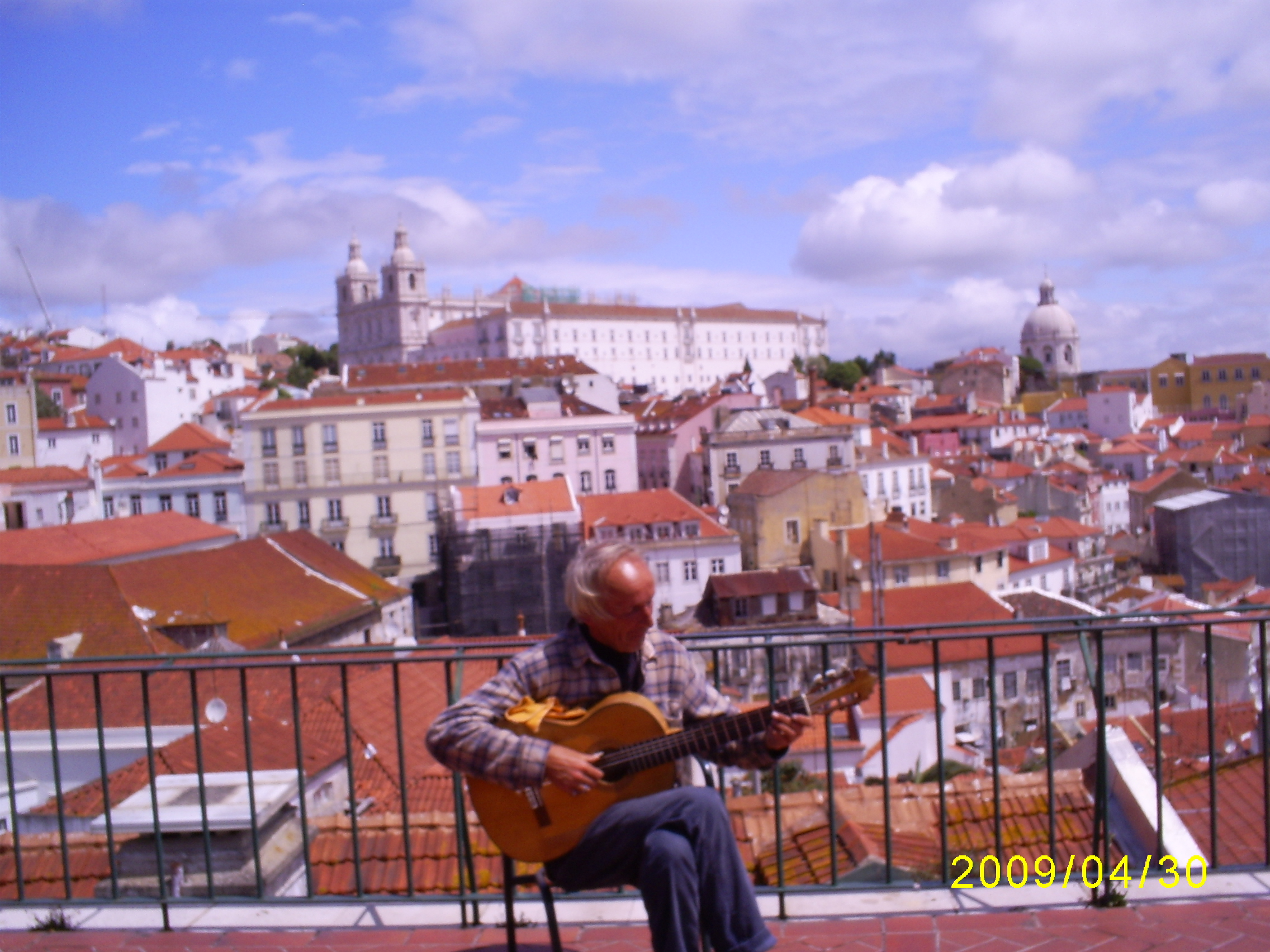
■ Fado, an urban romance played to the accompaniment of a twelve-string guitar, is a truly Portuguese genre. Usually it is a song about tragic love, drawn out and expressive. Professional fado performers - fadishtu - are popular all over the world today.
■ The town of Fatima, where in 1917 the miraculous apparition of the Mother of God, seen by three small children, took place, is famous as a center of worship of the Virgin Mary. Thousands of pilgrims come here every year. “What is the most important thing in traveling?
See, understand, enjoy, love!
Colors, shapes, aromas, tastes add up
into vivid pictures in memory, so that later we
could look at them all my life"
About the country, its history and people
Portugal is one of the oldest countries in Europe with a rich history. Portugal is charming country, which can be called a quiet European province, where virgin nature serenely coexists with a developed tourist infrastructure, and respect for national customs coexists peacefully with pan-European traditions.
The country of great navigators Portugal is located in the western part of the Iberian Peninsula. In the south and west it is washed by the waters of the Atlantic Ocean, on land it borders on Spain. Portugal includes the Azores, located in the Atlantic Ocean about 1,450 km west of Lisbon, and the island of Madeira, 970 km southwest of Lisbon, which are autonomous regions of Portugal. The area of the country, together with the islands, is 92.39 thousand square meters. km.
The name of the country comes from the name of the Roman settlement of Portus Cale at the mouth of the Douro River. In 1139, Portugal became an independent kingdom from Spain. At that time, it occupied only the northern third of its modern territory. In 1249, the last Muslim ruler in the south of the country was expelled, and since then its borders have changed little. The era of conquest began in the 15th century, when Portuguese maritime explorers such as Bartolomeu Dias, Vasco da Gama, Ferdinand Magellan traveled around the world, making great geographical discoveries. By the 16th century, the territories they discovered formed a huge empire that stretched from the coast of Brazil to Africa and Asia. It was during this era that the economy of Portugal reached its greatest prosperity.
In 1910, the monarchy was overthrown in Portugal, and in 1974 a democratically-minded military junta put an end to the dictatorial regime that had existed since 1926. Portugal is one of the few countries in Europe that was not occupied by Nazi troops during World War II.
The constitution adopted in 1976 declared Portugal a parliamentary republic with direct elections and universal adult suffrage.
Having handed over in 1999 the last of his overseas territories, Macao, which has been owned since 1680, under the control of China, Portugal put an end to a long and sometimes turbulent, colonial era in its history.
The events of Portuguese history had a huge impact on the culture of the country and introduced the features of Moorish and Oriental styles into architecture and art. Traditional folk dances and tunes, especially lyrical fado, do not lose their significance to this day, which can be seen and heard right on the streets. According to one version, the name fado comes from the Latin word fatum, which means fate. The melodies of the songs harmoniously combine Moorish, African and Brazilian melodies, the theme of loneliness, longing and foreboding of a sad fate runs through all the songs, but this does not mean that this type of music is suitable only for melancholics. The ability to sing of sadness, to turn it into an object of admiration is one of the national features of the Portuguese, and it is not for nothing that for several centuries almost every family in this country has been waiting for sons and husbands who went to conquer sea spaces, and the journey could end in the most unpredictable way.
The population of the country is mono-ethnic, 99% of the 10.8 million population are Portuguese. Many peoples have settled on the Iberian Peninsula for a long time. The most ancient inhabitants - the Iberians - were undersized and swarthy. Over the centuries, the appearance of the Portuguese was formed under the influence of the Celts, Phoenicians, Greeks, Romans, Arabs, as well as Germanic tribes (Visigoths and Alemanni).
Portugal is a monolingual country. The official language is Portuguese. It is spoken by more than 200 million people worldwide on three continents: Eurasia, Africa and South America. This language has similarities with Spanish, since both belong to the Ibero-Romance subgroup of the Romance group of languages, however, with a similar grammatical structure, there are significant differences in pronunciation between them. The formation of the language was greatly influenced by the Germanic tribes and the Arabs (Moors), from whom the Portuguese language borrowed many words, as well as the contacts of travelers, discoverers and merchants with Asian peoples.
National features: Do not question the historical greatness of the country - the Portuguese are proud of their past, especially against the backdrop of the modest place that the country occupies today. The Portuguese are very painful to compare them with the Spaniards, despite the similarity of languages, characters and national cultures. Bullfighting is also popular here, but, unlike the Spanish bullfight, where the bull is killed, in Portuguese the animal is pacified by a team of unarmed fighters (forkados).
In this country, the percentage rural population one of the highest in Western Europe, many foreigners work at its factories, construction sites and fields, including from Ukraine. Average annual income per capita: 22,500 USD (data from the World Bank, 2011). Average life expectancy is approaching 80 years. As in other countries, women in Portugal live longer, almost 82 years, while men still do not reach 76. The retirement age is 65 years, and the actual retirement age is 61-62 years.
Portugal is a country of great sea voyages, grandiose geographical discoveries and tart port wine. Mild climate, fresh forest and meadow aromas, light ocean breeze and endless expanses Atlantic, unique architecture in the style of "Manueline" and strong coffee ... All this deserves to get to know this interesting country better.
Wgetting to know Porto
They say about the cities of Portugal: they pray in Braga, they work in Porto, they party in Lisbon. My acquaintance with Portugal began from Porto. Porto, the second most populated city in Portugal with a population of 240 thousand inhabitants, gave its name not only to port wine, but to the whole country. The historical center of Porto is located on the right bank of the Douro River, a few kilometers from its confluence with the Atlantic Ocean. The city center has been declared a World Cultural Heritage by UNESCO.
Porto is well known for its entrepreneurial spirit, distinctive culture and local cuisine. The city is often referred to as the northern capital of Portugal. Porto is home to the largest university in Portugal (about 29,000 students).
One of the most striking sights of Porto is the Clerigos Tower - the highest in Portugal - 76 meters or 225 steps. The baroque church was built for the brotherhood of clerics ("Clerigos") by the architect Nicola Nasoni according to the Roman scheme. Its construction began in 1732 and ended in 1750 with the construction of a monumental staircase. July 28, 1748, despite the fact that the building was not yet fully completed, the church was opened for worship. Torre dos Clerigos has become the symbol of the city of Porto. It has been a National Monument since 1910.

The city is famous for the production of different brands of port wine. We visit one of the ancient "port wine houses" - Galem, get acquainted with the history and features of the production of this popular drink. And, of course, we taste some varieties, and whoever wants to buy the wines they like. Warming up the appetite with tasting wines, we begin our acquaintance with Portuguese cuisine in one of the restaurants, where we enjoy the national fish dish called “bacalau”.
Having refreshed ourselves with “bacalau” and tasting port wines, we walked with pleasure along the embankment of the Douro River, where such pretty boats float.
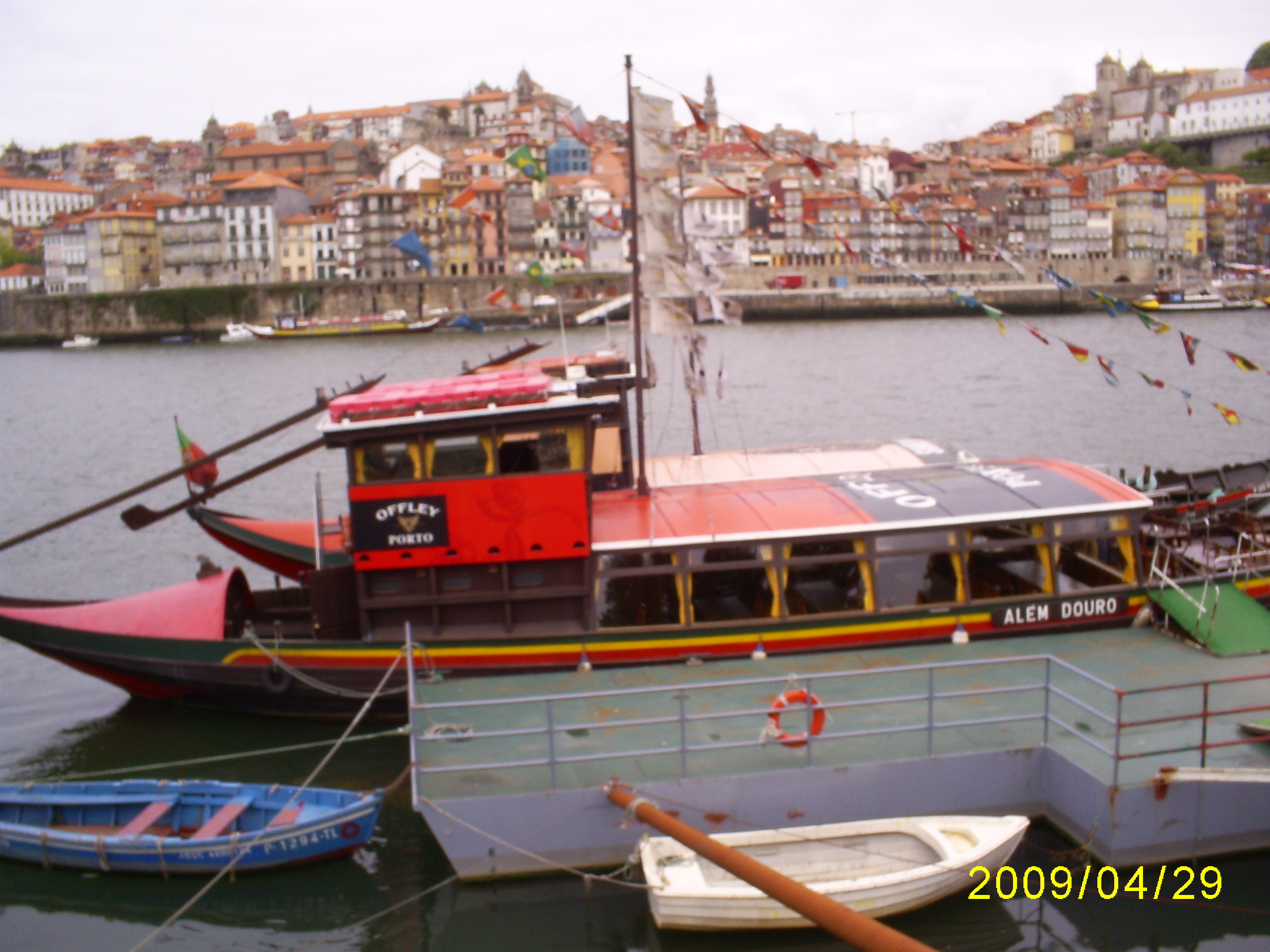
Four bridges are thrown across the Douro River, connecting the historical part of the city with Vila Nova de Gaia, a small neighboring town where the world-famous port wine is stored. One of the bridges (by Louis the First) was built according to the design of Gustave Eiffel: a two-tier structure of impressive size seems openwork and light.

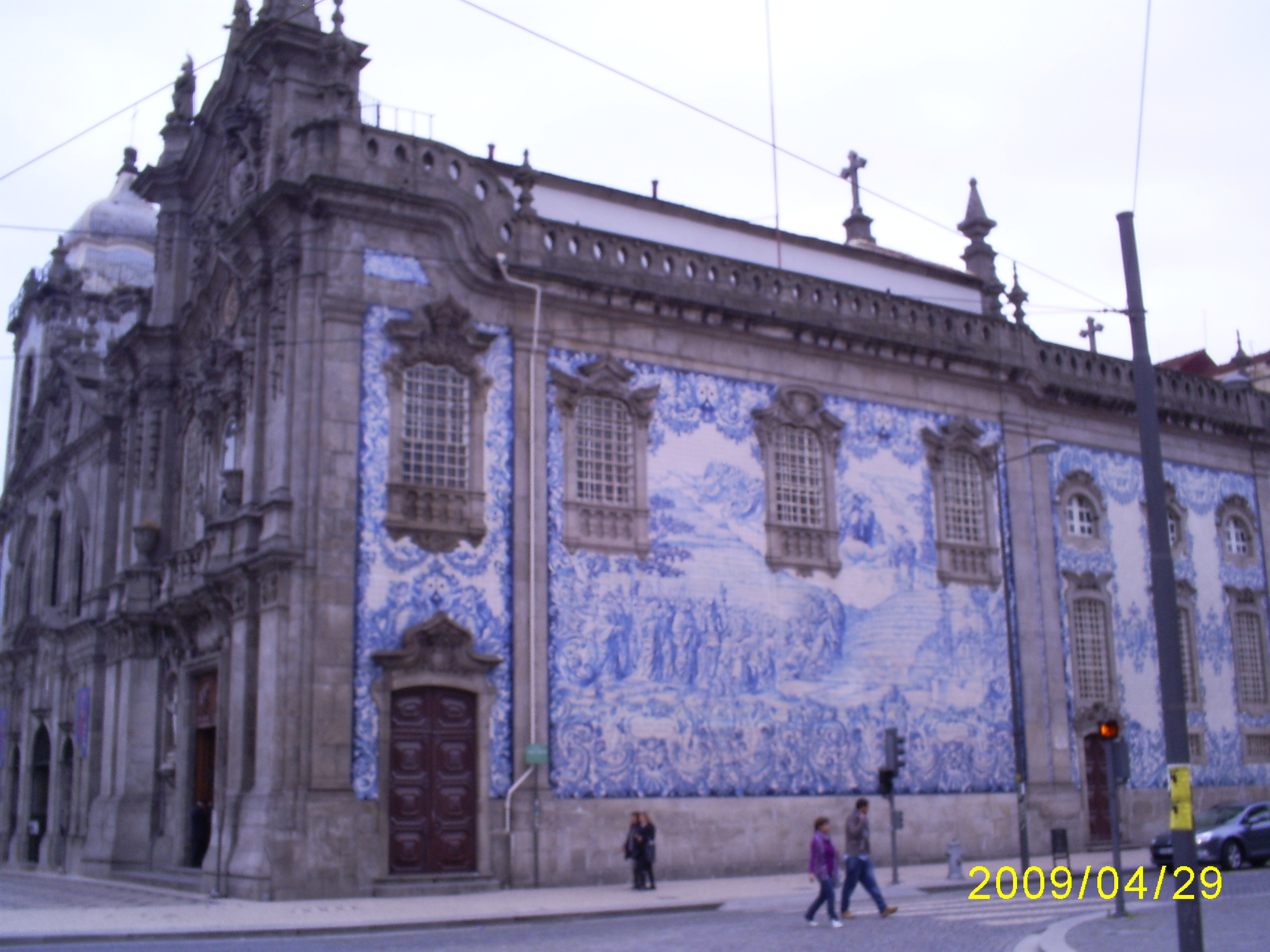
On the highest point of the old city, the Se Cathedral was built. Erected in the 12th century on a granite rock, it originally served as a fortress. Later it was rebuilt, but it has retained its severe appearance to this day. Inside the cathedral is not very interesting. Decor lovers will be impressed by the luxurious silver altar, the construction of which took 800 kg of silver, and the patio, lined with the famous Portuguese azulejo tiles.
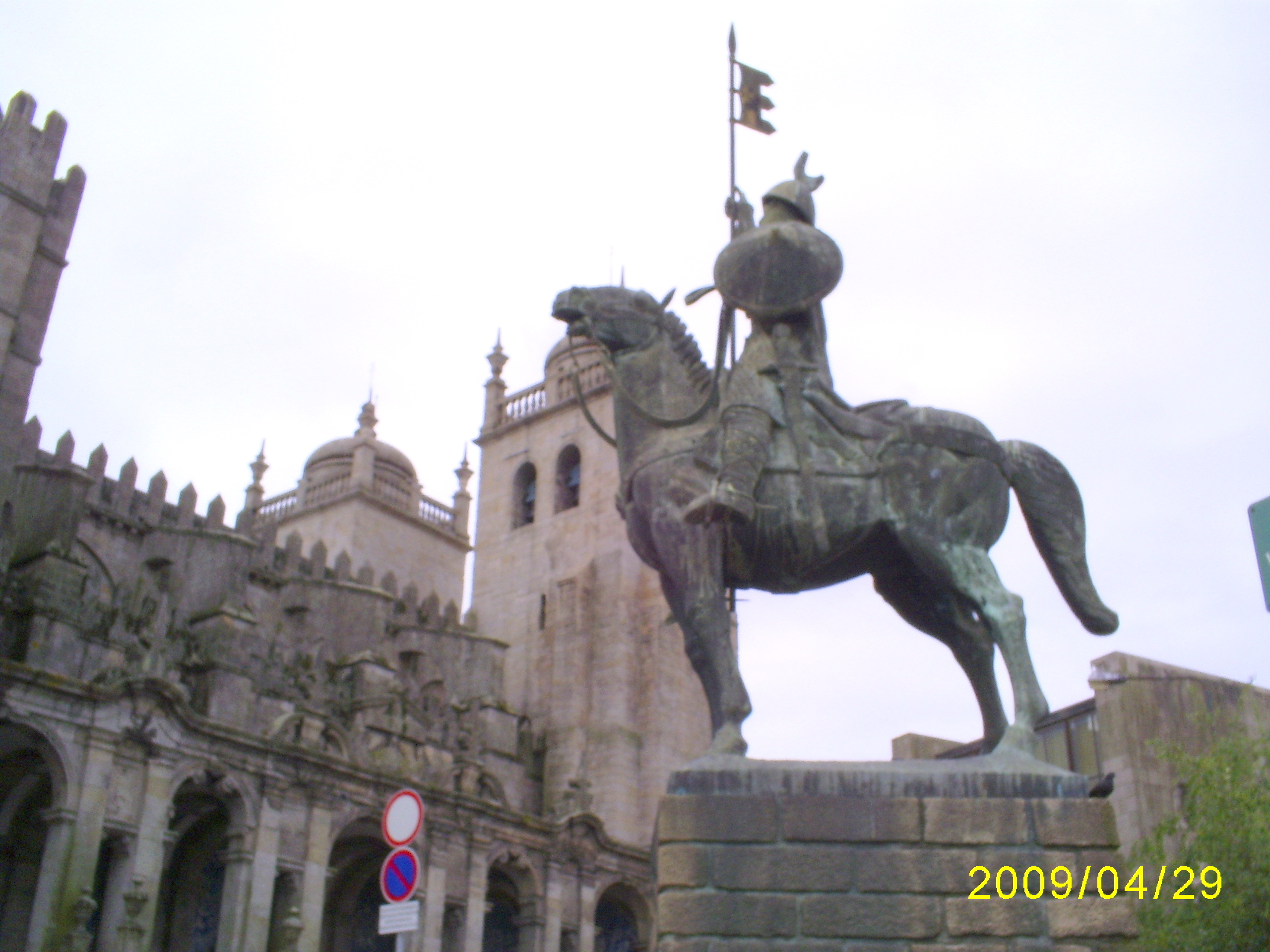
Cathedral Square offers a beautiful view of the city.
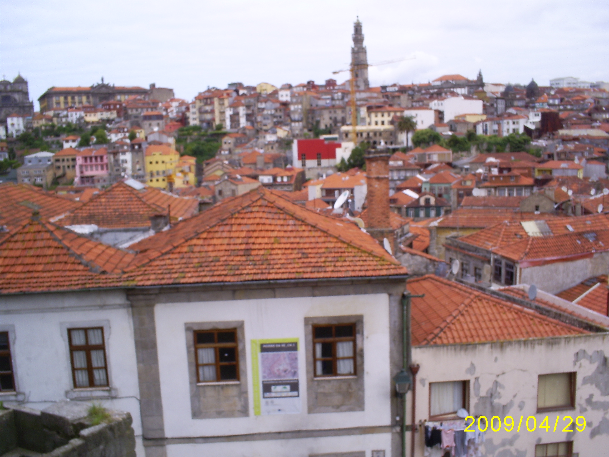
From cathedral the descent to the river goes through the poorest region of Porto. The area of luxurious villas is located near the ocean. You can get here on the current tram-museum, which has not changed since 1930. It's called the Electric Machine Museum. However, each of Porto's trams can serve as an exhibit: inside the vehicle is upholstered in wood, the driver drives it while standing, for the simple reason that there is no seat for it. When the tram reaches destination route, the driver moves from the head to the tail, where there is also a cabin, and drives his car in a “reverse course”: the rails in Porto end in a dead end. The most scenic route runs along the ocean coast. From the windows of noisy and old trams you can see fashionable villas, chosen by wealthy people from all over Europe.
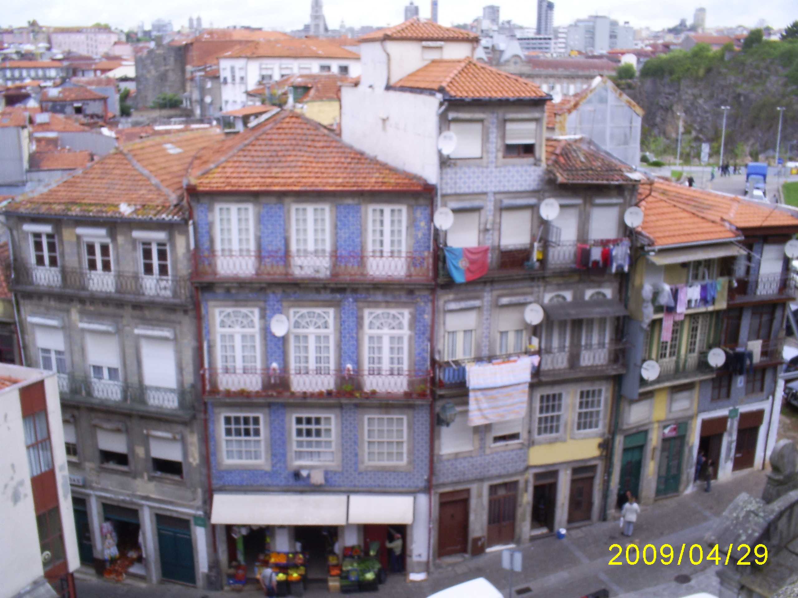
Porto, like other Portuguese cities, is distinguished not only by its peculiar architecture, but also by the fact that many houses are lined with multi-colored tiles.
From the early Middle Ages to the 17th century, there was a law that forbade the aristocracy not only to build, but also to stay in the city for more than three days. Even the king did not have his residence in Porto. He was visiting Bishop's Palace built by Nicolo Nazzoni. It is a masterpiece of 18th century Portuguese Baroque architecture. The port city is located all on the hills, it has many funny houses and streets.
It was also interesting to visit the store and a kind of book museum Livraria Lell - the oldest in Portugal and one of the most incredibly beautiful bookstores in the world. Unusual, simply fabulous interior, which is located on two floors of the store. Spectacular and massive decoration of the walls, ceiling, everything is made of noble wood using original and unusual carvings, combined with the surprisingly curved lines of the red staircase that leads to the second floor. No less impressive is the magnificent ceiling made of expensive stained glass. The bookstore is located five minutes walk from the city center.

This pretty fountain caught our attention.

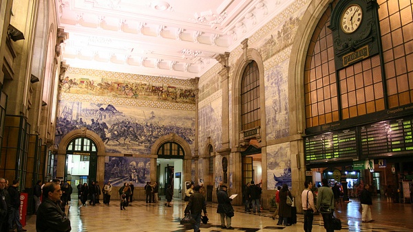
Not to mention the visit railway station Sao Bento. In addition to its direct destination, Sao Bento Station is interesting for its wall-paintings, lined with azulejos tiles in white and blue tones. The largest of them is made of 20 thousand tiles and decorates the waiting room. This panel completely occupies one of its walls. The picture depicts episodes from the history railways, and important points history of Portugal.
When leaving Porto, behind the fortress walls, my first meeting with the Atlantic Ocean took place. I go knee-deep into the ocean, the water is quite cool, but you can still take a dip.
Two days in Lisbon
Lisbon is the capital of Portugal and The largest city countries. 570 thousand people live in it. It is located on the right bank of the Tagus River, which flows into the Atlantic Ocean. Its history goes back about 20 centuries. Lisbon was built on seven hills, like Rome and Moscow. Just like Moscow, Lisbon is patronized by George the Victorious. The city became the capital of the state in 1147 after the liberation from Arab colonization. Lisbon owes this to the first king of Portugal, Alfonso Henriquez. Based main city The country was the Phoenicians as a stop at the crossroads of sea routes and named Alis Ubbo - a blessed bay. The city was under the control of the Roman Empire, the Moors, the Spaniards.

We begin our acquaintance with the center of Lisbon - one of the main attractions. In the 18th century, bullfights and public executions took place here. We visit the park of Edward VII and the monument to the Marquis de Pombal. This is a large green meadow with neatly trimmed bushes of the correct geometric shape.
Lisbon - modern European city, located on 15 hills. Walking on it you have to constantly go up and down from the hills. We climb one of the hills, where with the help of a guide we get acquainted with the Moorish fortress of Sant Jorge. Once upon a time, Portuguese kings lived here, and now only a shell with pine groves inside is left of the castle. But this is the highest point of Lisbon and the views from here are appropriate. You can see from the fortress walls strange building- openwork frames of arches poking into the sky. To take in the views of the Tagus River and ancient area Lisbon Alfama, we walked along the esplanade and climbed the rampart old fortress. The fortress of San Jorge (St. George) has been a fortification covering the mouth of the Tagus River since ancient times. In 1147, King Alphonse Enriques converted the fortress into a royal residence. In 1511, King Manuel I built himself a palace outside the fortress, and here he placed an armory and a prison. During the earthquake of 1755, the fortress was very badly damaged, and only in 1938, under Salazar, the ruins were restored, and only a few details remained, reminiscent of the original Moorish Alcasava, later the royal residence, where Vasco da Gama celebrated the success of his trip to India with pomp. The fortress walls have been restored and now you can walk around them old quarter Santa Cruz. Various exhibitions are arranged in the fortress towers, telling about the history of the fortress and the whole city. The viewpoints offer a magnificent view of Lisbon.

Picturesque streets with houses covered with painted tiles scatter from the fortress in different directions. Benches are carefully placed in the middle of each lift. Most of the streets lead to Alfama - the most old quarter Lisbon, which, being built on rocky ground, survived the earthquake without much damage. Here once was the center of the Roman city, and later - the center of the Moorish city. Jews also lived in Alfama until their expulsion in the 16th century. There is nothing reminiscent of the capital city: Alfama is more like a fishing village, where housewives clean fish right on the street and scribble on antediluvian sewing machines, and ropes with linen are tied to orange trees growing right on the steps. Going for a walk in Alfama, tune in to the fact that, most likely, you will get lost - this intricacies of streets practically defies logic.

We go down from the castle on a retro tram running along route No. 28, which resembles the transport of the beginning of the last century, and go on a tour of the city center. We pay tribute to how our tram famously climbs the hills and rushes along the narrow winding streets with a frightening rattle. At one of the moments of the trip, we easily reach the wall of a neighboring house with our hands.

We get off at the bus stop and before us opens an amazing view of the capital. In Lisbon, such observation terraces are called miradores. We found ourselves on the best of them - Miradouro de Santa Luzia. We approach the fence and freeze in admiration. No wonder Lisbon is called the “White City”: in front of us is a whole block of like toy, sun-drenched snow-white houses with orange tiled roofs.

There are many interesting buildings of unusual architecture in the city.
We descend to Commerce Square, which is considered one of the most beautiful squares in Portugal. Before the earthquake, there was a building built in 1511 by Manuel I Royal Palace. In its center, on a high plinth, rises an equestrian statue of the reformer king José I, whose minister was the Marquis de Pombal. Majestic Triumphal Arch, decorated with bas-reliefs and statues of famous people and connecting the square with Augusta Street, was completed in the 19th century. Then the square got its present name "Commerce Square" due to its proximity to the port, which is the main source of trade in the city. From here you have a magnificent view of the Tagus River, to which you can go down the stairs. Two square towers rise from the south side of the square, and buildings of ministries and banks frame the square on three sides.

The next point of our trip is the Belem area. Where the Tagus flows into the ocean, stands Belem (that is, Bethlehem) watch tower, and a little closer to land rises the monastery of Jeronimos - an excellent example of the main national style - Manueline, that is, Gothic mixed with Arabic script, sea knots and astrolabes. Two world-famous Portuguese are also buried here - Vasco da Gama (who set off from the Belem Tower, setting off in search of an alternative route to India) and Luis Camões. True, only one tomb remained of Camões, the poet himself died of the plague and was buried in some kind of lost common grave.

Nearby is the coffee shop Casa dos Pastéis de Belém, where they make the best sweets in the city, and perhaps in the country.
Next to the monastery is the Bethlehem Tower (Torre de Belen), built in the 16th century, the symbol of Lisbon. This is one of the best examples of the Manueline style, the tower is under the protection of UNESCO. It is decorated with lanterns, openwork Venetian balconies, stone carvings, a statue of the Madonna of the Navigators under a huge canopy and a sculpture of a rhinoceros. From the inside, the tower looks quite gloomy - there used to be a prison here. The quadrangular Belen Tower is known as a monument Portuguese Era Great Geographical Discoveries. The tower, built in 1515-1520 and designed in the Manueline style, is a classic symbol of all of Portugal. This tower was erected in honor of the glorious military and maritime past of Portugal and rises on the spot where caravels once set off to distant lands.

Not far from the Tower on the embankment of the Tagus River in the direction of the April 25 Bridge is the Monument to the Navigators.

What is Lisbon remembered for, in addition to its historical sights? First of all, original architecture that combines different styles. We fell in love with its squares and streets, lined with tiles of various configurations and colors. His numerous souvenir shops with all kinds of colored tiles and products from it did not leave indifferent. The city also has one of the largest oceanariums. With pleasure we drove along the famous tram route No. 28 along its steep streets and with no less pleasure - underground on the metro in modern cozy cars, admired the original interior of its stations.

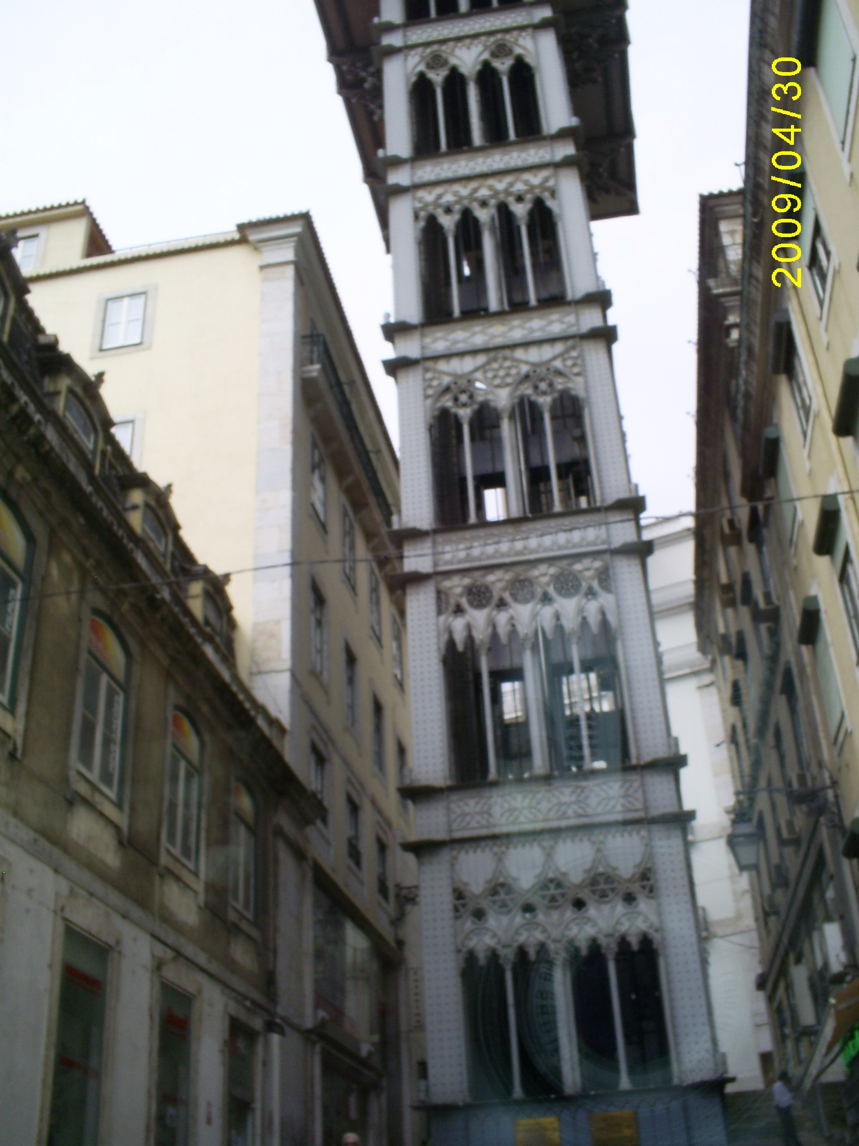
It's time to say goodbye to hospitable Lisbon. We are passing through one of the most long bridges Europe. 45 months after the start of work (half a year ahead of schedule), on August 6, 1966, a solemn opening ceremony took place in the presence of the highest officials of the state. The structure was named "Salazar Bridge" in honor of the then dictator of Portugal. Shortly after the Carnation Revolution, the bridge was renamed in honor of the day when this event took place - the April 25 Bridge.

Royal Sintra
In the morning we leave Lisbon and head to Sintra. At 27 km from Lisbon at the foot of the low coastal mountains of the Sierra da Sintra is located small town Sintra, which has been on the list since 1995 world heritage UNESCO. The Portuguese themselves consider it the main attraction of the country, the pearl of Portugal. Back in the 8th century, the Moors appreciated the defensive significance of this place and built a fortress here. In 1147, Afonso I Henriques drove out the Arabs and for the next 600 years the city was the summer residence of the Portuguese kings.
Among the luxurious parks, centuries-old forests, bewitching landscapes, palaces, castles, monasteries that amaze the imagination rise on the hills.
Located in the city itself National Palace Sintra, and in the adjacent mountainous and forested area on a hill - the Palacio da Pena Palace and the dilapidated Castle of the Moors.

Near the station there is a beautiful city hall.
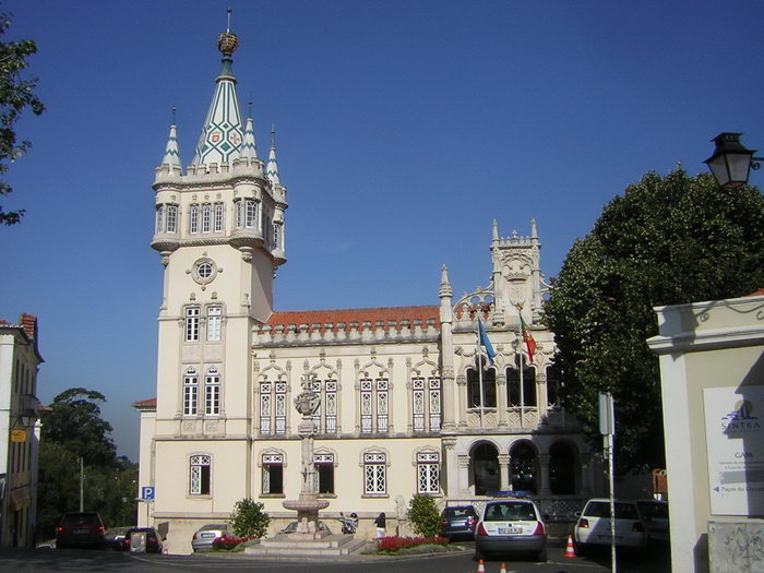
Before climbing the mountain to the Palacio da Pena Palace, we walk with pleasure in the urban part of Sintra, built up with old mansions. The streets wind whimsically and often end with steep stairs, steps lead to observation terraces, which offer stunning views of the mountains and the ocean. The urban landscape abounds with green forests, exotic flowers and exquisite palaces.

In the city you can find many castles and palaces that have been preserved in their originality. These castles contain an important historical and artistic collection, which attracts Portuguese and foreign artists to the city. Interesting and original are not only castles and palaces, but also houses in this fabulous city.

The proximity of the ocean and the mountain ranges provide humid, cool and slightly windy weather, which is great for relaxing even in very hot summers. That is why, already in the 15th century, the summer residence of the royal family of Portugal became fairytale castle Palacio da Pena, which, together with its luxurious park, crowns one of the highest hills of Sintra. Located 450 meters above the city of Sintra, it is one of the most significant examples of Portuguese architecture of the Romantic period. Rising on a rocky hill, it surprisingly harmonizes with the surrounding landscapes, combining lush vegetation and rocky cliffs.
The palace was founded in 1839 when the husband of the Portuguese Queen Maria II Ferdinand II of Saxe-Coburg-Gotha (1816 - 1885) purchased the ruins of the Jerome Monastery and began to rebuild them according to his romantic taste in order to create here summer residence. In order to realize his fantasies, Ferdinando II turned to a German friend, Baron Eschwege, for help and appointed him the construction manager. And since in the 19th century, romantically minded architects no longer hesitated to mix different styles, the castle, like a three-dimensional puzzle, was assembled from German and Portuguese towers, Moorish arches and courtyards, and Indian domes. And to top it off, they painted it all in bright colors, which delights not only adults, but also children. The whimsically eccentric architecture of the palace combines Moorish, Gothic and Manueline motifs and the spirit of castles. Central Europe. The palace stands on the top of the mountain, it can be bypassed along the perimeter along a special path. Ferdinand II also built here one of the most spectacular parks in Portugal, which was designed and planted for over 4 years, starting in 1846.
This most beautiful and romantic castle in Portugal is jokingly called "Snow White's Palace" and is often compared to the Bavarian Neuschwanstein. Pena Palace can be reached by bus number 434 from the city center for 4.5 euros, but you can also get on the path on foot.

We climb the rock where the fortress built by the Moors between the 9th and 10th centuries is located. During the capture by the Christians, the fortress surrendered without a fight. After the 15th century, the fortress lost its strategic importance. From above, a wonderful landscape opens: among the sea of greenery, you can see the blue ocean and the white-red roofs of settlements and the capital.

We go down on foot to feel the beauty of the surrounding nature more strongly. The entire slope of the mountain is littered with huge boulders, as after a collapse or rockfall. It is not clear how tall trees can grow on these stones.

I pass by the ruins of an old Moorish fortress - once life was stormy here, and now only dilapidated stone walls remind of its former greatness.

Royal Sintra will forever be remembered as one of the most harmonious places in the world, combining both beautiful landscapes created by Mother Nature and man-made palaces and castles created by talented architects. Lord George Gordon Byron, admiring the beauty of Sintra, called it a paradise, and then forever immortalized the town in the famous poem “Great Paradise”.
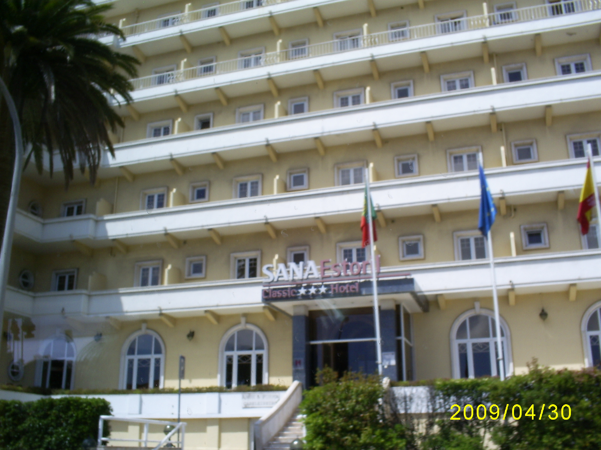
The resort towns of Cascais and Estoril
After lunch we head to the westernmost point of Europe - Cape Roca. The path to it runs along the "Portuguese Riviera", with a visit to the resort towns of Cascais and Estoril. Although Lisbon stands on the coast of the ocean, there are no beaches in the city and those who want to plunge into the depths of the sea or just relax on the coast, Lisbon people go to these nearby resort cities. These cities are very nice and cozy.
15 km west of Lisbon is a magnificent resort - Estoril. It has a unique microclimate: warm and sunny summers, moderate temperatures the rest of the year. It is from the resort of Estoril that the tourism industry of Portugal originates. A little over a century ago, the amazing beauty of nature and the mild Atlantic climate attracted the world's elite and representatives of famous aristocratic families to Estoril. Gorgeous sandy beaches, the purest water and inaccessible to a mere mortal, hotels are traditionally in demand among people of considerable income. Fans of outdoor activities will enjoy an incredible variety of water sports activities, including 8 newest water parks, and excellent golf courses.
Her Majesty the Queen of England often rests in Estoril, and the notorious Linda Evangelista has chosen a villa for herself. We pass by the hotel where our first and only President of the USSR, Mikhail Gorbachev, had a rest.
Located just a few kilometers from Estoril and 20 kilometers from Lisbon, Cascais is a typical example of Portuguese architecture with brightly colored tiled roofs and white walls lined with colorful ceramic tiles.
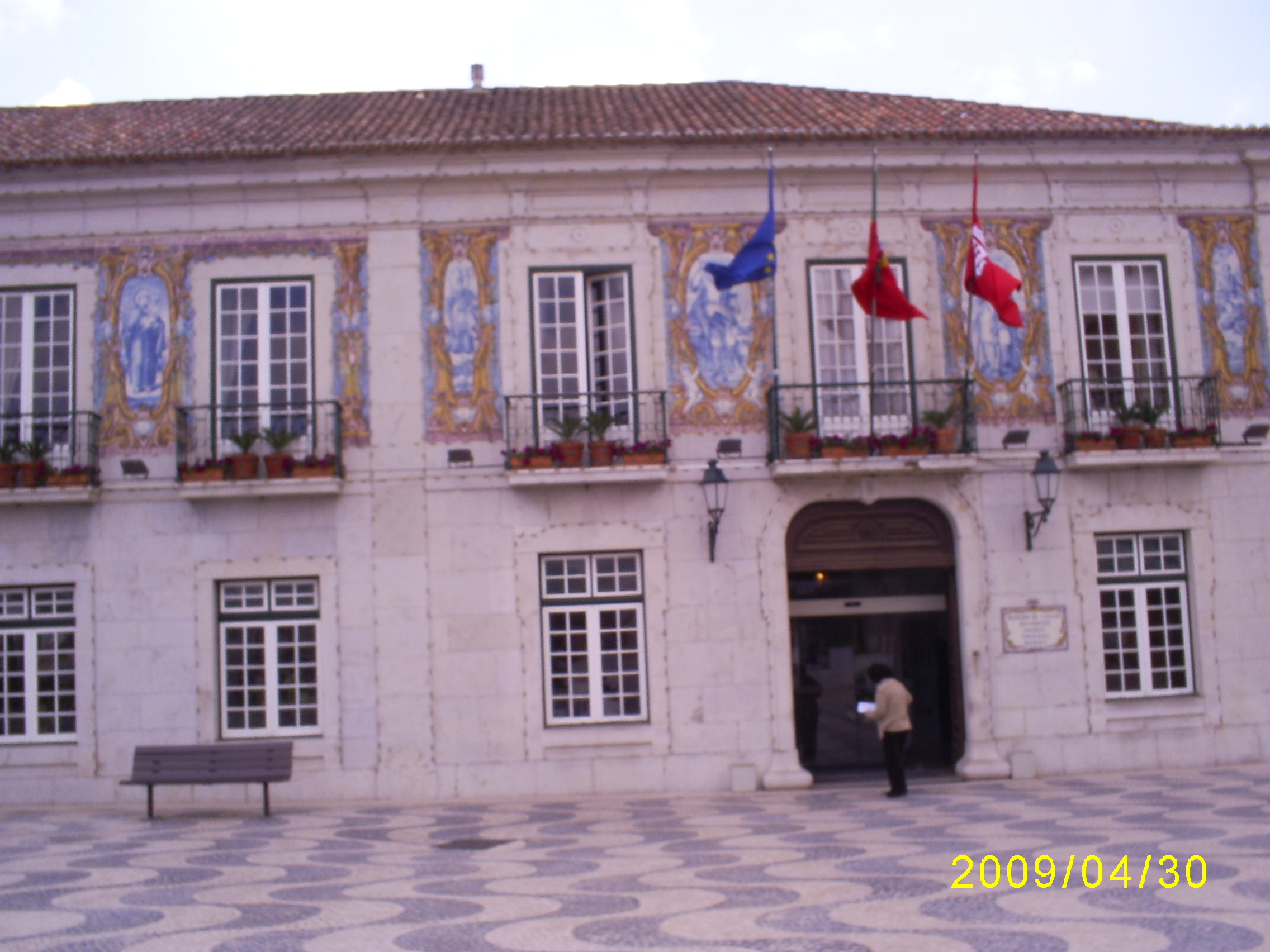
The name Cascais comes from the word cascale - "small stone". The city has a rich historical and architectural ensemble: a history museum, a maritime museum, churches and chapels of the 15th century. There is a monument to Don Pedro in the Central Square.

IN small town there are other monuments. We liked this sculptural warrior.

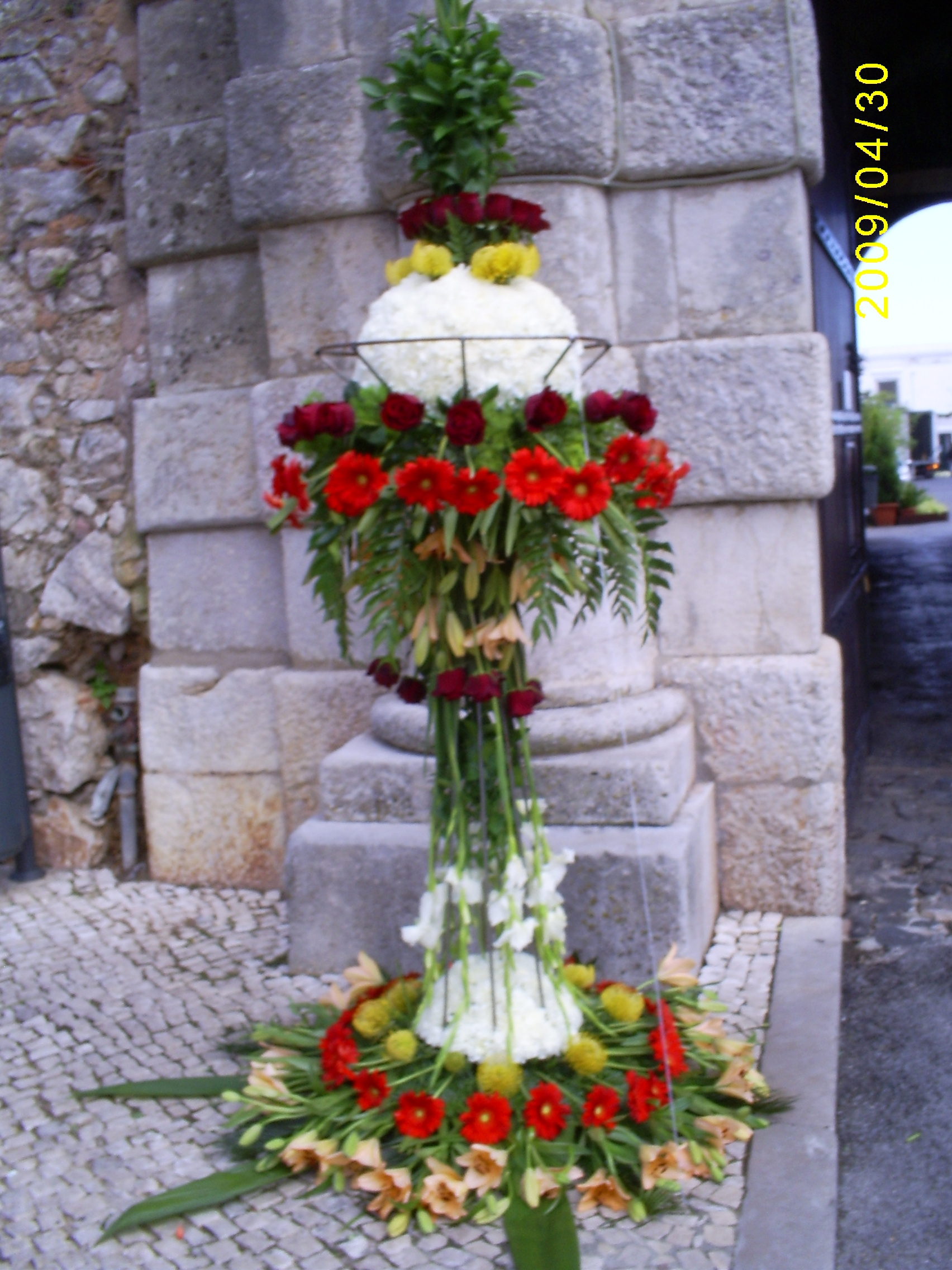
I really liked this unusual pretty bouquet.
A very attractive walk through the upper city with a well-groomed city park and the romantic castle of the Aristocrat.

If you move further from the city along the rocky coast, you will find yourself in Guinsha - the realm of wide dunes with frequent storm winds. This corner untouched nature is a real paradise for windsurfers. Here is the picturesque cliff of Boca de Infierno (“the mouth of the underworld”): the sea has washed out a hole in the rock, and now “infernal stew” is constantly boiling in these stone jaws.

capeCabo deRoca
The mountain road leads to a cliff from which a dizzying panorama of the ocean and coastal cliffs opens. This is the westernmost point of Europe, Cape Cabo de Roca, which became a tourist attraction only in 1979. Before that, the "end of the world" on the Iberian Peninsula was considered the Spanish Cape Finisterre (lat. "end of the earth"). A rock 140 meters high, like the prow of a ship, protrudes into the ocean. Ignoring the protective barrier, I approach its edge. Standing at the very edge, I listen to the solemn music of the ocean and fill with its energy. Probably, the great Portuguese navigators, standing on the western shores of their native continent and peering into the boundless ocean distances, asked themselves the question: “What is beyond these distances?” and to find the answer to this question they went on long sea voyages.
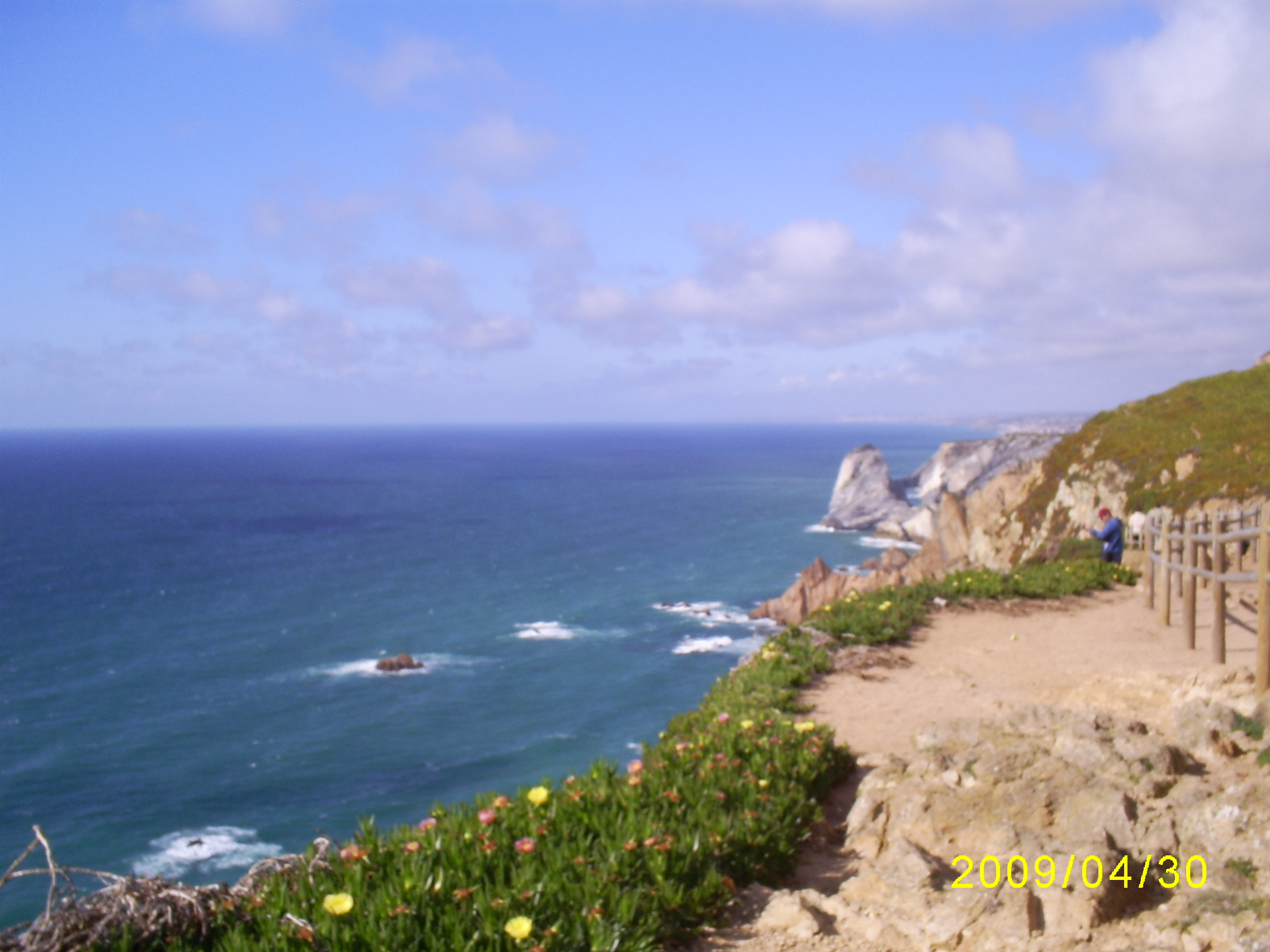
We overcame here a difficult journey by bus through many European countries from the westernmost point of our native Ukraine, the Transcarpathian city of Chop (48º05′ N, 22º08′ E). Photographed for memory with our yellow-blue national flag next to a stone stele, on which the coordinates (38º47′ N, 9º30′ W) and the inscription “ Onde a terra acaba e o mar comeca….". Shrouded in mist or illuminated by the bright sun, this place is one and only, where, as the poet Camões said: TOthe earth ends and the ocean begins» , - this is how the words carved on a stone stele sound in translation.

This is a memorial stone.

As evidence of my presence in such a charismatic place, I purchase a personalized certificate from the Cape service center that I really was here. On reverse side in different languages, including Russian, the following words are written: “ I certify that I was at Cape Roca in Sintra, in Portugal, at the westernmost point of the European continent, at the very edge of the world, “where the earth ends and the ocean begins”, where the Spirit of Faith, Love and a thirst for adventure prompted the Portuguese caravels to set off on their journey to searching for a new world» .
The souvenir shop has a lot of different products about staying in the westernmost point of Europe, especially a lot of souvenirs with drawings on various ceramic products. I choose a fridge magnet in the form of a small ceramic tile with the image of a cape as a memento of visiting this unique place.

But the main thing that we take away from this place is the memories of what the westernmost point of our native European continent looks like. The turquoise smoothness of the Atlantic caresses the eye, and the menacing rocks evoke legends of tragic, unrequited love.

We have reached the extreme point of our native continent, and with this I end my story about the journey through the Iberian Peninsula, my Iberian Romance.
By the end of the 15th century, Europeans were quite ready for long-distance sea voyages. On geographical maps they began to depict the cardinal directions, a grid of parallels and meridians, and scales of distances. Back in the 14th century, the Chinese compass was improved in Italy: the floating magnetic needle was now attached to a disk with divisions. Based on the Arab ships with a slanting sail, the Spaniards and the Portuguese created a new type of vessel - caravel. These ships could keep their course in any direction of the wind with the help of an oblique sail and at the same time develop great speed thanks to the direct sails. They were small in size, did not require a large crew, and at the same time were so high that it made it possible to store enough provisions in the holds.
Henry the Navigator
One of the first who was carried away by the idea of long-distance sea voyages was the Portuguese prince Henry the Navigator(1394-1460). As a young man, he learned from books about the possibility of reaching countries rich in gold, moving on ships around Africa.
Prince Henry sent ships south every year, but the captains, having brought the ships to Cape Bojador (26 ° north latitude), turned back. The view of the desert shores hot by the sun terrified the sailors, reminding them of the flaming abyss of hell, where the souls of sinners burn. There was a legend that the navigator who rounded Cape Bojador would never return. Between the sailors there were conversations: “How can we step over the boundaries drawn by our ancestors, and how much benefit will there be from the death of our souls and our bodies?” Only in 1434, one of the captains, fearing the wrath of Prince Henry, overcame fear and went around the "devil's" cape. As proof of the existence of life in the south, he presented his ruler with wild roses brought from there.
Every year, the Portuguese ships went further and further south, moving along the coast of Africa. Each new expedition brought reports of unprecedented animals and plants, strange customs of the black inhabitants of this continent.
Bartolomeu Dias and the Cape of Good Hope
Finally, in 1488, the crew of the ship Bartolomeu Dias(1450-1500) managed to go the farthest. The exhausted team demanded to turn to their native shores. It cost the captain incredible efforts to persuade the sailors to sail a little more. Two days later, the flotilla sailed to the cape, behind which the African coast turned to the north. The Indian Ocean stretched out before the sailors. Subsequently, this cape was called the "Cape of Good Hope" - the hope that soon the sea route to India would be opened.
Vasco da Gama travel to India
After 10 years, on July 8, 1497, four ships sailed off the coast of Portugal, led by a confidant of the king, a nobleman Vasco da Gama. They prepared for the expedition very seriously: they selected people who could be relied upon and who possessed the necessary knowledge, maps were verified, navigation devices were purchased. On the way, we often had to repair wind-worn ships. From the lack of fresh fruits and vegetables, the sailors suffered from scurvy. Their teeth fell out, their bones ached, and many died. Already beyond the Cape of Good Hope, the sailors met with Arab merchants. Not wanting to let rivals into India, the Arabs refused to give the Portuguese a pilot familiar with the winds and currents of the Indian Ocean. Only by chance in one of the ports did they manage to hire an Arab sailor.
In May 1498 Vasco da Gama's flotilla saw the shores of India. In the huge port of Calicut (the modern city of Calcutta), the local sultan allowed the Portuguese to stand next to the Arab and Indian ships and buy pepper and spices. Only two ships and less than half of the sailors held the path to their native shores, but the goods they brought were sold at a price many times greater than the cost of their purchase, equipment and the entire expedition. material from the site
Portuguese India
Now in Portugal everyone was ready to rush for oriental goods. Lacking the strength to capture vast territories, the Portuguese limited themselves to occupying convenient bays. Small fortresses were erected on their banks - forts, bristling with cannons. At first they were built along the entire African coast. After that, a large Portuguese fleet entered the Indian Ocean and began to destroy Arab merchant ships. Having become the masters of the Indian Ocean, the Portuguese forced the rulers of the coastal cities of India to trade spices only through them. Portuguese trading settlements arose near Indian cities - trading posts. In 1510, the Portuguese captured the first Indian city on the coast - Goa. A fortress was created here, soldiers settled. The King of Portugal appointed and sent there the Viceroy of the Portuguese possessions in India.
Moving further east, the Portuguese found out that the spices themselves were produced not in India, but on the islands of Indonesia. Having reached them in 1511, the Portuguese squadron approached the port of Malacca. Merciless cannon fire destroyed the walls of the fortress and put to flight even the war elephants of the local ruler. So in the hands of the Portuguese was the strait, through which all the trade in spices went. Now nutmeg and cloves were shipped directly to Europe. Along the established local trade routes, the Portuguese soon reached China and Japan, where their trading posts also appeared. All forts, trading posts and local cities became Portuguese colonies, that is, territories deprived of local government and under the authority of officials sent from the invader country - metro-poly.
Portuguese discoveries in America
Questions about this item:


