How to find mountains on the map. Mountain systems of the world
The process of formation of mountains on Earth takes millions of years. They arise from the collision of huge tectonic plates that make up the earth's crust.
Today we will get acquainted with the highest mountains on 6 continents and see how they look against the backdrop of the highest mountain peaks in the world - the "eight-thousanders", whose height above sea level exceeds 8,000 meters.
How many continents are on Earth? It is sometimes believed that Europe and Asia are 2 different continents, although they are one mainland:

Before we start talking about the highest mountains on 6 continents, let's take a look at the general diagram of the highest peaks on Earth.
"Eight-thousanders"- this is a common name for the 14 highest mountain peaks in the world, whose height above sea level exceeds 8,000 meters. They are all in Asia. The conquest of all 14 "eight-thousanders" of the planet - the conquest of the "Crown of the Earth" - is a great achievement in high-altitude mountaineering. As of July 2012, only 30 climbers have managed to do this. (Clickable, 2010×810 px):

North America - Mount McKinley, 6,194 m
This highest double-headed mountain North America, named after the 25th President of the United States. Located in Alaska.

Indigenous peoples called this peak "Denali", which means "great", and during the period of Russian colonization of Alaska, it was simply called Big Mountain.

Mount McKinley, view from national park Denali:

The first ascent of the main summit of McKinley took place on June 7, 1913. There are 5 large glaciers on the slopes of the mountain.

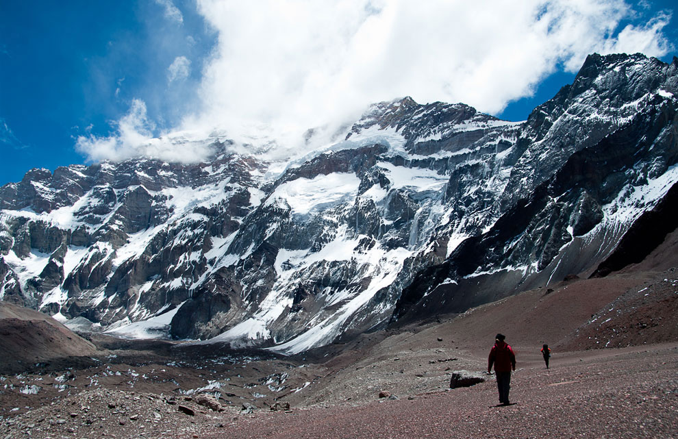
South America - Mount Aconcagua, 6,962 m
This is the highest point American continent, South America as well as the western and southern hemispheres. They belong to the longest mountain range in the world - the Andes.

The mountain is located in Argentina and in the Quechua language means "Stone Guardian". Aconcagua is the largest dormant volcano on our planet.

In mountaineering, Aconcagua is considered technically an easy mountain if you climb the northern slope.

The first recorded ascent of the mountain was in 1897.
Europe - Mount Elbrus, 5,642 m
This stratovolcano in the Caucasus is the highest peak in Russia. Considering that the border between Europe and Asia is ambiguous, often Elbrus is also called the highest European mountain peak. (Clickable, 2500×663 px):

Elbrus is a two-headed volcano with a saddle. The western peak has a height of 5642 m, the Eastern one - 5621 m. Last eruption dated to 50 AD...

At that time, the eruptions of Elbrus probably resembled the eruptions of modern Vesuvius, but differed greater strength. From the craters of the volcano at the beginning of the eruption, powerful clouds of vapors and gases, saturated with black ash, rose many kilometers up, covering the entire sky, turning day into night. The earth shook from powerful tremors.
Today, both peaks of Elbrus are covered with eternal snow and ice. On the slopes of Elbrus, 23 glaciers diverge in different directions. average speed The movement of glaciers is about 0.5 meters per day.

The first successful ascent to one of the peaks of Elbrus was made in 1829. The average annual number of deaths while climbing Elbrus is 15-30 people. (Clickable, 1650×630 px):

Everest (Chomolungma) is the top of our world! The first eight-thousander in height and the highest mountain on Earth.

The mountain is located in the Himalayas in the Mahalangur-Himal range, and the southern peak (8760 m) lies on the border of Nepal, and the northern (main) peak (8848 m) is located in China.

Everest has the shape of a trihedral pyramid. At the top of the Chomolungma, there are strong winds blowing at speeds of up to 200 km / h, and the air temperature at night drops to -60 Celsius.

The first ascent to the summit of Everest took place in 1953. Since the first ascent to the summit until 2011, more than 200 people have died on the slopes of Everest. Now the climb to the top takes about 2 months - with acclimatization and setting up camps.
View from space:

Climbing Everest is not only extremely dangerous, but also expensive: the cost of climbing in specialized groups is up to 65 thousand US dollars, and the climbing permit issued by the government of Nepal alone costs 10 thousand dollars

Australia and Oceania - Mount Punchak Jaya, 4884 m
The most high peak Australia and Oceania, which is located on the island New Guinea. It is located on the Australian Plate and is the most high mountain in a world located on an island.

The mountain was discovered in 1623 by the Dutch explorer Jan Carstens, who saw a glacier at the top from afar. Therefore, sometimes the mountain is called the Pyramid of Carstens.

The first ascent of Puncak Jaya took place only in 1962. The name of the mountain from the Indonesian language is translated approximately as "Victory Peak".

These are the most high mountains Antarctica. The existence of the mountain range became known only in 1957. Since the mountains have been discovered American planes, subsequently they were named the Vinson Massif, in honor of the famous American politician Carl Vinson.

View of the Vinson Massif from space:

This is the highest point in Africa, a huge dormant volcano with two well-defined peaks in the northeast of Tanzania. The mountain has had no documented eruptions, but local legends speak of volcanic activity 150-200 years ago.


The higher one is the peak of Kibo, an almost regular cone with powerful glaciation.

The name comes from the Swahili language and supposedly means "mountain that sparkles".

The snow cap that covered the top of the mountain for 11,000 years since the last ice age melts quickly. Over the past 100 years, the volume of snow and ice has decreased by more than 80%. It is believed that this is not caused by a change in temperature, but by a reduction in the amount of snowfall.

The highest peak in Africa was first conquered by the German traveler Hans Meyer in 1889.

The process of formation of mountains on Earth takes millions of years. They arise from the collision of huge tectonic plates that make up the earth's crust.
Today we will get acquainted with the highest mountains on 6 continents and see how they look against the backdrop of the highest mountain peaks in the world - the "eight-thousanders", whose height above sea level exceeds 8,000 meters.
How many continents are on Earth? It is sometimes believed that Europe and Asia are 2 different continents, although they are one mainland:

Before we start talking about the highest mountains on 6 continents, let's take a look at the general diagram of the highest peaks on Earth.
"Eight-thousanders" is the common name for the 14 highest mountain peaks in the world, whose height above sea level exceeds 8,000 meters. They are all in Asia. The conquest of all 14 "eight-thousanders" of the planet - the conquest of the "Crown of the Earth" - is a great achievement in high-altitude mountaineering. As of July 2012, only 30 climbers have managed to do this.

North America - Mount McKinley, 6,194 m
This is the highest two-headed mountain in North America, named after the 25th President of the United States. Located in Alaska.

Indigenous peoples called this peak "Denali", which means "great", and during the period of Russian colonization of Alaska, it was simply called Big Mountain.

Mount McKinley as seen from Denali National Park:

The first ascent of the main summit of McKinley took place on June 7, 1913. There are 5 large glaciers on the slopes of the mountain.

South America - Mount Aconcagua, 6,962 m
This is the highest point of the American continent, South America, as well as the western and southern hemispheres. They belong to the longest mountain range in the world - the Andes.

The mountain is located in Argentina and in the Quechua language means "Stone Guardian". Aconcagua is the largest extinct volcano on our planet.

In mountaineering, Aconcagua is considered technically an easy mountain if you climb the northern slope.

The first recorded ascent of the mountain was in 1897.

Europe - Mount Elbrus, 5,642 m
This stratovolcano in the Caucasus is the highest peak in Russia. Considering that the border between Europe and Asia is ambiguous, often Elbrus is also called the highest European mountain peak.

Elbrus is a two-headed volcano with a saddle. The western peak has a height of 5,642 m, the Eastern one - 5,621 m. The last eruption dates back to 50 AD ...

In those days, the eruptions of Elbrus probably resembled the eruptions of modern Vesuvius, but were more powerful. From the craters of the volcano at the beginning of the eruption, powerful clouds of vapors and gases, saturated with black ash, rose many kilometers up, covering the entire sky, turning day into night. The earth shook from powerful tremors.
Today, both peaks of Elbrus are covered with eternal snow and ice. On the slopes of Elbrus, 23 glaciers diverge in different directions. The average speed of glaciers is about 0.5 meters per day.

The first successful ascent to one of the peaks of Elbrus was made in 1829. The average annual number of deaths while climbing Elbrus is 15-30 people.

Asia - Mount Everest, 8,848 m
Everest (Chomolungma) is the top of our world! The first eight-thousander in height and the highest mountain on Earth.

The mountain is located in the Himalayas in the Mahalangur-Himal range, and the southern peak (8760 m) lies on the border of Nepal, and the northern (main) peak (8848 m) is located in China.

Everest has the shape of a trihedral pyramid. At the top of the Chomolungma, there are strong winds blowing at speeds of up to 200 km / h, and the air temperature at night drops to -60 Celsius.

The first ascent to the summit of Everest took place in 1953. Since the first ascent to the summit until 2011, more than 200 people have died on the slopes of Everest. Now the climb to the top takes about 2 months - with acclimatization and setting up camps.
View from space:

Climbing Everest is not only extremely dangerous, but also expensive: the cost of climbing in specialized groups is up to 65 thousand US dollars, and the climbing permit issued by the government of Nepal alone costs 10 thousand dollars

Australia and Oceania - Mount Punchak Jaya, 4884 m
The highest peak in Australia and Oceania, which is located on the island of New Guinea. It is located on the Australian Plate and is the highest mountain in the world located on an island.

The mountain was discovered in 1623 by the Dutch explorer Jan Carstens, who saw from afar into the glacier at the top. Therefore, sometimes the mountain is called the Pyramid of Carstens.

The first ascent of Puncak Jaya took place only in 1962. The name of the mountain from the Indonesian language is translated approximately as "Victory Peak".

Antarctica - Windson Massif, 4,892 m
These are the highest mountains in Antarctica. The existence of the mountain range became known only in 1957. Since the mountains were discovered by American aircraft, they were later named the Vinson Massif, after the famous American politician Carl Vinson.

View of the Vinson Massif from space:

Africa - Mount Kilimanjaro, 5,895 m
This is the highest point in Africa, a huge dormant volcano with two well-defined peaks in the northeast of Tanzania. The mountain has had no documented eruptions, but local legends speak of volcanic activity 150-200 years ago.


The higher one is the peak of Kibo, an almost regular cone with powerful glaciation.

The name comes from the Swahili language and supposedly means "mountain that sparkles".

The snow cap that has covered the mountaintop for 11,000 years since the last Ice Age is melting fast. Over the past 100 years, the volume of snow and ice has decreased by more than 80%. It is believed that this is not caused by a change in temperature, but by a reduction in the amount of snowfall.

The highest peak in Africa was first conquered by the German traveler Hans Meyer in 1889.
All cat sleeping positions
Physical map of the world allows you to see the relief of the earth's surface and the location of the main continents. A physical map gives a general idea of the location of the seas, oceans, complex terrain and elevation changes in various parts of the planet. On the physical map of the world, you can clearly see the mountains, plains and systems of ridges and highlands. Physical maps of the world are widely used in schools in the study of geography, as it is the basis for understanding the main natural features various parts of the world.
Physical map of the world in Russian - relief

PHYSICAL WORLD MAP displays the surface of the Earth. The space of the earth's surface contains all the natural resources and wealth of mankind. The configuration of the earth's surface predetermines the entire course of human history. Change the boundaries of the continents, stretch the direction of the main mountain ranges in a different way, change the direction of the rivers, remove this or that strait or bay, and the whole history of mankind will become different.
“What is the surface of the Earth? The concept of surface has the same meaning as the concept of geographic shell and the concept of biosphere proposed by geochemists... The earth's surface is voluminous - three-dimensional, and taking the geographical shell of an unambiguous biosphere, we emphasize the paramount importance of living matter for geography. The geographic envelope ends where the living matter ends.
Physical map of the hemispheres of the Earth in Russian

Physical map of the world in English from National Geographic

Physical map of the world in Russian

Good physical map of the world in English

Physical map of the world in Ukrainian

Physical map of the Earth in English

Detailed physical map of the Earth with major currents

Physical world map with state borders - Wikiwand Physical world map with state borders


Map of the geological regions of the earth - Geological map of the world "s regions

Physical map of the world with the ice and clouds - A physical map of the world with the ice and clouds

Physical map of the Earth - Physical map of the Earth

Physical map of the world - A physical map of the world

The great importance of the structure of the continents for the fate of mankind is indisputable. The gulf between the eastern and western hemispheres disappeared only 500 years ago with the travels of the Spaniards and the Portuguese to America. Prior to this, ties between the peoples of both hemispheres existed mainly only in the northern part of the Pacific Ocean.
The deep penetration of the northern continents into the Arctic for a long time made the paths around them inaccessible. northern shores. The close convergence of the three main oceans in the area of three mediterranean seas created the possibility of their connection with each other naturally (Strait of Malacca) or artificially (Suez Canal, Panama Canal). Mountain chains and location predetermined the movement of peoples. Vast plains led to the unification of people under one state will, strongly dissected spaces contributed to the maintenance of state fragmentation.
The dismemberment of America by rivers, lakes and mountains led to the formation of Indian peoples, who, due to their isolation, could not resist the Europeans. Seas, continents, mountain ranges and rivers form natural boundaries between countries and peoples (F. Fatzel, 1909).
The map shows the largest mountain systems in the world - ten on land and ten on the ocean floor. Their length is given with an accuracy of 100 km.
A higher accuracy would hardly be justified, since the mountains almost never end abruptly, but gradually pass into the plain; only for mountains with their ends directly approaching the sea can the extent be measured with greater accuracy (for example, the Pyrenees). In large mountain systems consisting of many parallel ridges, the result of the measurement will depend on which of the ridges to measure.
The belonging of individual mountain ranges to one mountain system or another is not always clearly defined: should Mugodzhary, for example, belong to the Urals or not? In our table, the length of the Urals is given without Mugodzhar, but you can decide otherwise.
On the land

At the bottom of the ocean

The question of independence can also concern very large mountain systems.
So, many, not without reason, perceive the Cordillera mountain belt as a single entity, including the Cordillera of South America - the Andes. True, the main part of the Cordilleras of North America was formed in the Hercynian era of folding (Late Paleozoic) and in the Cimmerian (Mesozoic), and South America - in the Alpine (Cenozoic); but one glance at the physical map is enough to see a single mountain system along pacific coast all of America.
Another difficult question: whether to single out as independent mountains included in another, more major system, also marked on the map? In the above table (it was compiled according to the data of the Geographical Encyclopedic Dictionary) and on the map, Rocky Mountains, which are part of the Cordillera system of North America, but such a decision is not indisputable.
It is easy to see that there is no connection between the length of mountain systems and their height. Nine of the ten highest peaks in the world are concentrated in the Himalayas, occupying a modest eighth place on land in terms of length, and one more (by the way, the second in absolute mark after Chomolungma) is located in Karakoram, which did not enter the top ten at all: it is four times shorter than the Urals, occupying last place in our table.
In fourth place in terms of length is the Great Dividing Range in Australia, and its height is more than three times less than the height of the Tien Shan, which occupies the seventh place.
Heights are not given in the table of underwater mountain systems: the depths of the highest points do not in any way characterize the height of mountains above their foot - oceanic depressions; some peaks of underwater ridges come to the surface, representing islands (Iceland) and mountains on them (Hekla in Iceland, Mauna Loa volcano in Hawaii).
Among the longest mountain structures on the ocean floor, those that belong to the global system of mid-ocean ridges predominate.
And here the problem of dividing the system of mid-ocean ridges into parts is manifested with even greater clarity.
Are we entitled to single out the North Atlantic, South Atlantic, African-Antarctic, West Indian and Arabian-Indian ridges as independent, if all of them, being a continuation of each other, form a single system with a length of 25 thousand km, that is, significantly more than from pole to pole?
But even being divided into parts, as it is done in the table, the underwater mountain systems are noticeably longer than the continental ones.
If the continental and seamounts are summarized in a common table, then the Transantarctic Mountains, which are in third place among the continental mountain systems, go to tenth place.
Thus, even in such a seemingly simple matter as the selection of the ten largest mountain systems in terms of length, there can be many controversial issues.
Himalayan range

A linearly elongated raised relief, with clearly defined slopes, is called a mountain range.
The size, length and shape of the mountain range is determined by both its rocks and the era of origin and history of development. highest points the ridge, in turn, form its crest. All major mountain ranges, as a rule, have branches, the so-called spurs. Usually they are much smaller than the main ridge.
by the most high ridge in the world is considered the Main Himalayan Range - the third step of the Himalayas.
It also includes the highest mountain in the world - Chomolungma. Its height is 8848 m, although recent measurements made with modern equipment by the Italian geologist A. Desio indicate that the height of this mountain top already 8 km 872.5 m.
It extends from the Hindu Kush mountain range (separating India and Afghanistan) to the Dang-la ranges located in China.
It is worth noting that its average height is 5.5 - 6 km above sea level. And in a relatively small area, located between the Arun and Sutlej rivers, 8 out of 10 mountains of the Himalayas are concentrated, the height of which is more than 8000 m.
Facts about the Himalayan Range

The passes that lead through the Great Himalayan Range are on average 4.8 km high, but some of them can be higher than 6 km.
The greatest width of the third step of the Himalayas is about 70-90 km in the area between the Sutlej and the Indus. In the same place main ridge branches into 2 parts - the Northern Range and the Western Himalayas.
As a rule, mountain ranges serve as a watershed separating basins of lakes, rivers, seas and even oceans.
But the largest mountain range in the world is an exception. Not only did this ridge not divide Indian Ocean, through it in various places flow like the most major rivers Tibet - Brahmaputra and Indus, and their tributaries - Setledzh, Gandak, Arun and Gogra.
The fact is that these rivers flowed here even before the Himalayas formed. As you rise rocks, rivers formed gorges in them. That is why the Main Himalayan Range is not solid throughout its entire length, but, as it were, consists of huge pieces, sometimes called links of the Himalayan Range.
Svetlana Shevchenko, Samogo.Net


Physical map of the world allows you to see the relief of the earth's surface and the location of the main continents. A physical map gives a general idea of the location of the seas, oceans, complex reliefs and heights in different parts of the planet. On the physical map of the world, you can see mountains, plains, and systems of reefs and peaks.
Cards physical world are often used in schools in the study of geography, as they are basic for understanding the main natural features of different parts of the world.
Physical map of the world in Russian - relief

The PHYSICAL MAP of the WORLD shows the surface of the Earth. The surface of the earth's surface has all natural resources and wealth of mankind.
The configuration of the earth's surface predetermines the entire course of human history. Change the borders of the continents, pull the other direction of the main mountainous areas and change the direction of the river, remove either the bay or the strait, and the whole history of mankind would be otherwise.
? “What is the surface of the Earth The concept of the surface has the same meaning as the term geographic shell and put forward the concept of the biosphere ... the surface area of the Geochemists of the Earth. - three-dimensional, and the geographical shell of the unique biospheric, emphasized the exceptional importance of living organisms of geography. The geographical shell ends when the living thing is over.
Physical map of the hemisphere of the Earth in Russian

Physical map of the world in English from National Geographic

Physical map of the world in Russian

Good physical map of the world in English

Physical map of the world in Ukrainian

Physical map of the Earth in English

Detailed physical map of the Earth with major currents

Physical world map with country borders - Physical world map with borders


Map of the Geological Regions of the Earth - Geological map of the regions of the world

Physical map of the world with ice and clouds - physical map of the world with ice and clouds

Physical Map of the Earth - Physical Map of the Earth

Physical map of the world - physical map of the world

The enormous importance of the structure of the continents for the fate of mankind is undeniable.
The difference between the eastern and western hemispheres disappeared 500 years ago from the trips of the Spaniards and the Portuguese to America. Prior to this connection, the peoples of both peninsulas existed primarily in the North Pacific.
The global intrusion of the northern continents into the Arctic has long prevented a route around their northern shores.
The closest convergence of the three major oceans into three inland waters created their potential connection between natural (Straits of Malacca) or artificial (Suez Canal, Panama Canal). The mountain range and the location of the predetermined movement of nations. Vast plains bring people together under one government, which will greatly reduce the space, helping to maintain a state of fragmentation.
The discovery by America of rivers, lakes and mountains led to the birth of the Indian nation, which, because of its isolation, could not abstain from the Europeans.
The sea, continents, mountain ranges and rivers are natural boundaries between countries and peoples (F. Fatzel, 1909).
The highest mountain systems in the world and the highest mountain systems on the continents
 A third of the land area is occupied by mountains. The mountains are different: from low, overgrown with forests and more like hills, to magnificent mountain ranges. Below are the highest mountain systems in the world and their highest peaks.
The highest mountain system in Eurasia
Highest mountain range The continent of Eurasia is located in Asia, on the territory of several countries, in the Himalayas.
The area occupied by the Himalayas is about 650 thousand square kilometers.
The Himalayas are also the highest mountain range in the world. “Good” the height of its peaks is 6 km, and this is the highest peak in the Himalayas (and the whole world too) - Mount Chomolungma, or, in other words, Everest. The height of Everest has been tested by dozens of ascents of desperate climbers and is 8848 meters.
The highest mountain system in Europe
Mont Blanc, the highest mountain in Europe, is located in the Alps.
Its height is 4807 meters. The Alps are the most studied human mountain system, regardless of what climbers call mountain peaks.
The reefs and arches of the Alps are an arc, the length of which is about 1200 kilometers, and the inner side is 750 km, the width is about 260 kilometers.
The highest mountain system in Africa
The highest mountain system in Africa is the East African Plateau.
In addition to being part of this system is also Africa's highest peak, Kilimanjaro Volcano (5895 meters), Victoria Falls is also the largest continent in the East African Plateau and is the source of the most big river in the world.
The highest mountain range in North America
The highest mountain range on the continent of North America is called the Cordillera.
This mountain system extends along the tread along west coast North America, its length is about 7,000 kilometers, and its width is up to 1,600 kilometers. The highest mountain is the peak of the Cordillera - McKinley, its height is 6193 meters.
The highest mountain system in South America
The highest mountains in South America are the Andi. Their average height is 4 km, and the highest peak of the Andes is Mount Aconcagua.
The height of Aconcagua is 6962 meters.
The highest mountain range in Australia
In Australia, the highest mountain system is the 400-kilometer mountains of the Australian Alps.
The highest mountain in Australia - the peak of Kosciuszka is part of this plateau. The height of Kosciuszko Peak is relatively low - 2228 kilometers.
The highest mountain system in Antarctica
There are mountains in Antarctica and they are called Ellsworth Land.
The highest peak of this mass is called Vinson, its height is 5140 meters.
More interesting geographic information