Message about the ancient cave cities of the Crimea. Where is Chufut-Kale Steep slopes protected the inhabitants of Kyz-Kermen from enslavement by the hordes of the Mongol-Tatars
The cave cities of Crimea beckon and attract with their mystery. Who are these masters who built these marvelous passages, carved entire temples in blocks of rocks and created such eternal masterpieces?
Cave cities are found in different parts of the world: in Tunisia, China, Chile, Turkey, Georgia, etc. And there are the same cave cities in the Crimea. It should be noted that on the Crimean peninsula there are several cave cities which were built at different times and by different peoples. But they are united by the same talent of craftsmen who, at the cost of enormous labor, created such structures.
Chufut-Kale: Khan's city
How to get there: Chufut-Kale is located 3.5 kilometers from Bakhchisaray. Getting to Chufut-Kale is very easy, you can ride on fixed-route taxi that run to this place, or walk along the street. River, bypassing the Assumption Monastery.
Chufut-Kale
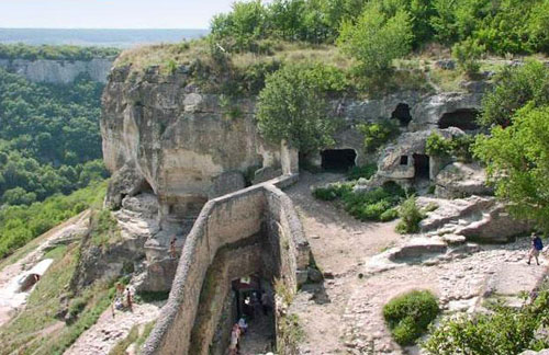
Just three kilometers from Bakhchisaray is an amazing city in the rocks - Chufut-Kale. Here you can see both the complexes of the cave city, with galleries, steps carved into the rock and cave temples, as well as individual buildings built in different eras. According to researchers, this settlement was founded by the Alans in V-VI centuries, as a defensive structure on the borders of the Byzantine Empire.
According to scientists, this is the city of Fulla, mentions of which can be found in various sources. But then the city passed into the hands of the Kipchaks, who called this place Kyrk-Er, who left the city in the same way after the Nogai invasion in 1299. During the Golden Horde period, this was the capital of the Crimean Khanate. The city actively developed and strengthened. It was during this period that tower fortifications, fortress walls, industrial buildings and even a mint were built, which indicates the special status of the settlement. At the same time, Karaites began to settle in the city. The city began to be called Chufut-Kale and became the residence of the first Crimean khans.
But over time, the city of Salachik (today a suburb of Bakhchisaray) was founded in the valley, where the Khan's palace was built and the entire court moved here. Chufut-Kale remained an armed outpost for some time, where the khan could hide in time of danger, but still the city gradually died out. For a long time only Karaites remained here, but then they left, leaving only a few delightful kenas within the walls of Chufut-Kale.
Mangul-Kale: the stone capital
How to get there: For those who want to visit Mangul on their own, it is most convenient to get from Bakhchisarai. Drive to the village of Sala Khodja and then walk to the mountains along the path.
Mount Mangul rises in a beautiful and picturesque place between Sevastopol and Bakhchisaray. From a bird's eye view, Mangul resembles a lily, thanks to the huge plateau at the top. It was here that Mangul-Kale, the capital of Theodoro, the first Christian principality on the Crimean peninsula, was built. The principality existed during the heyday of the Byzantine Empire VI-XV, and then fell after it. Although quite recently, archaeologists discovered the remains of settlements in this place that date back to the 1st millennium BC. That is, people have chosen this plateau in the Neolithic era.
It should be noted that this is the largest cave city of the Crimean peninsula, which was located on the territory of about 90 hectares. It was a huge impregnable fortress on the rocks. Nature itself took care of the safety of this place. As the capital of the principality, the city was self-sufficient. There were industrial production, a mint, a city prison, princely mansions, defensive towers, Christian churches and other buildings. The city was provided with water, and this was the most important condition in those days.
The Principality of Theodoro was quite famous during its heyday. Theodoro's ambassadors were not only in Byzantium, but also in the Moscow principality, and children from noble families of both states came to serve in the principality. The last prince of Theodoro was Alexander, who was executed by the Turks after the capture and defeat of Mangul-Kale in 1475. But even after the fall of Theodoro, the city continued to exist for another three hundred years, first as a Turkish fortress, then as a Russian one. But still, Mangul-Kale gradually turned into a ghost town, and today it is a rather ruined, but still such a majestic outpost that looks down on the bustling life of people from above.
Exi-Kermen: the most "cave" city of Crimea
To get to Eksi-Kermen you need to go to the village. Zalesnoye near Bakhchisarai. By car, it is better to get through the village of Krasny Mak.
Six kilometers from the village of Zalesnoye there is another cave city that you should definitely visit if you come to Crimea. This is Exi-Kermen. In translation, the name of the city means "old fortress" and indeed the original task of the city was to guard the approaches to Chersonese. It was a fortified fortress with massive city walls, fortresses and ramparts. It is worth noting an interesting decision of the builders, who hollowed out longitudinal beds in the rocks, on which they erected walls.
But in 1299, the Golden Horde, led by Nogai, destroyed the city, to the ground, only cave complexes survived. Further, Eksi-Kermen already existed as an open settlement. Almost all buildings were two-story. The first floor was a cave carved into the rocks, which was used for auxiliary and household needs, and the second floor was built on from stone or wood. And almost all houses had balconies.
It is the cave structures that have survived to our times, and these are about 350 caves within the city and another 50 around the settlement. There is no such large cave complex in Crimea anymore. Of particular interest is the Temple of the Three Horsemen. This is a sanctuary carved into a semicircular rock, which is decorated inside with ancient frescoes depicting saints and scenes from the Old Testament. According to scientists, these frescoes hide a mystery that they cannot yet unravel.
Also on the territory of Exi-Kermen, tombs carved into the rock and a siege well, the depth of which exceeds 50 meters, have survived to this day.
Tepe-Kermen: Fortress on top

Tepe Kermen
Like many other cave cities of the Crimea, Tepe-Kermen performed defensive functions. Indeed, it is not so easy to destroy buildings carved into the rocks, and few people have succeeded. But ground structures suffered much more often. Tepe-Kermen was built from the beginning of the 6th century AD as a border fortress of the Byzantine possessions. The settlement rises on a 300-meter cliff, which is surrounded by sheer cliffs and forest. Great artists and writers who have been here compare this place with a huge altar that rises in the middle of the valley.
Tape-Kermen was not much inferior to Chufut-Kale or Eksi-Kermen.
The size of the city can be judged by the cave complexes, which have been perfectly preserved to our time. There are about 250 caves here, and many of them have several tiers, which are connected by steps carved into the rocks.
The heyday of the city fell on the XI-XIV centuries, but after the attack of the Golden Horde in 1299, it gradually dies. Although in the 16th century a cave monastery was functioning here.
Of particular interest is cave church, with a semicircular altar and a hollowed out altar. The church was supposedly built in the VIII-IX century. Its special sign is the irregular shape of the window. For a long time, these windows were one of the unsolved mysteries of Tepe-Kermen, the answer to which scientists received by chance. It turns out that on Easter day, the rays of the rising sun, penetrating through these windows, form a cross on the altar.
Pre-Christian sanctuaries were also found on the territory of the settlement, which indicate that people lived here long before the arrival of the Byzantines. The history of this little-studied complex is still full of mysteries.
Kyz-Kermen: the city of legends
From Simferopol, you can drive to the village of Red Poppy, and get off at the monument to fallen soldiers. Then move towards the rocks along a dirt road.
Kyz-Kermen cannot be considered the same cave city as Tepe-Karmen or Chufut-Kale. Firstly, this city was founded much earlier than others. The first settlements here were founded by the Scythians and Tauris, who chose this almost impregnable rock, which resembles a frying pan with an outstretched handle. It is this "handle" that is the only passage to the rock, which is surrounded on all sides by sheer cliffs. And secondly, Kyz-Kermen, this is one of the settlements that did not belong to the Byzantine Empire, but was a border outpost of its opponents - the Khazar Khaganate.
Directly opposite Kyz-Kermen there is a rock where the remains of Tepe-Kermen are located and there are many legends that unite these cities. One of them speaks of a bridge that was built across the gorge separating these settlements. But in reality, this could not be, and not because it was impossible to build, but simply because at the time of the heyday of Kyz-Kermen, no one had yet heard of Tepe-Kermen. Another mystery of Kyz-Kermen was discovered during excavations of the remains of the fortress wall. This is the skeleton of a child, which is immured right between the walls. It is believed that this was a sacrificial offering and it was believed that such spirits would protect this place from enemy raids.
There are not so many cave structures in Kyz-Kermen - only three. This is a military gatehouse, a monastic cloister and a stone water cistern in one of the estates. By the way, there are no such siege wells as in other cities. But springs were found in secret grottoes, which are still filled with clean water. Around these sources, numerous remains of clay shards were found, among which were found the remains of ancient Greek amphoras, which were made two thousand years ago, which means that the history of Kyz-Kermen is even more ancient.
The story about the campaign "Kyz-Kermen and Teper-Kermen: the conquest of the legend"
Cachi Kalyon: a city surrounded by vineyards

Kachi Kalyon
In fact, today there are no vineyards here anymore, but the fact that a thousand years ago there were a lot of them here is evidenced by many facts. Kachi-Kalyon is unusual city, which cannot be put on a par with other cave cities of Crimea. This city has never acted as a defensive structure. Of course, there were protective walls and towers, but they served only to protect the city's crops and maintain order.
Kachi-Kalyon was a huge grape processing complex. And if it is easier to say - the first plant. In almost every cave in the city, and there are about two hundred of them here, you can find tarapans - primitive presses for squeezing juice, hollowed out right in the rock. The researchers considered that productive capacity city, could simultaneously process about 250 tons of grapes, and if you multiply this by the whole season, very impressive numbers are obtained. Basically, all the juice was exported, that is, it was such industrial city who lived off trade.
If you look at Kachi-Kalyon from the bottom up, you cannot help but notice the many stones that strew the local hills. Probably, collapses or earthquakes often happened here, as evidenced by scattered pieces of rocks with roaches, inverted caves and even the remains of temples. And, most likely, this was one of the reasons why this city was empty. Researchers suggest that the Karaites who settled in Chufut-Kale came from here.
On the territory of the city there is a spring, which has the name "Saint Anastasia". Its water is considered healing, especially for women.
The guides finish their tours of Kachi-Kalyon in the Big Grotto, which was of particular importance for the city. From it, along a narrow path, the width of which was only 40 cm, one could go to the Small Grotto. There was a belief that only a person with a clear conscience could go through it, and not fall into the abyss. But today this path is covered with a collapse and it is no longer possible to get into the Small Grotto along it.
The story of the campaign "From Kachi-Kalyon to the Syuyren fortress"
Bakla: the granary of the Crimea
From Simferopol, you can get here by train, leaving at the Pochtovaya station, then walk to the village. Rocky.

This cave city is located away from the well-known tourist routes on the very border between the mountain and steppe Crimea. This city cannot boast of its inaccessibility, but its uniqueness lies in its inconspicuousness. You can really find the settlement only. Only coming close to its walls.
The main part of the city is located on a wide plateau, which resembles a balcony over a valley.
So what is so special about this city? It has never been a military settlement, and no defensive structures have been found here, which is rather strange, because during any skirmishes between the mountainous and steppe Crimea, Bakla was on the front line. In addition, during the study of the ancient settlement, many stone pines were found, hollowed out directly in the rock. Pine is a huge jar made of clay, which was used in antiquity to store goods. The stone pines at Buckle were used to store grain. The capacity of each vessel is about two tons, and about 120 of them were found in total. That is, the grain reserves that were stored in the city were quite impressive.
But Buckle's mysteries don't end there. It is still not clear who and when founded this settlement. An ancient sanctuary was discovered on the territory of Bakla, the walls of which are dotted with incomprehensible signs, crosses and pagan symbols. But at the same time found ancient greek temple with hollowed-out niches for candles, around which it is written in ancient Greek: "The scent of candles is joy."
Xuiren: the mystery of the white fortress
You can get to the Syuyren fortress by regular buses that run along the Simferopol-Sevastopol route, reaching the village of Maloye Sadovoye. Climb towards the Chelter-Koba cave monastery and continue along the path to the mountains, the path will lead you straight to the plateau.

The Syuyren fortress was built to strengthen the borders of the principality of Theodoro, but it is possible that there were also more ancient settlements. The hallmark of this bastion, destroyed today, is White Tower, which rises on an impregnable plateau.
There is not much information about the Syuyren fortress, it has not yet been established who nevertheless destroyed this city, although many assume that this happened during the capture of Crimea by the Golden Horde in the 13th century. The remains of fortress walls, towers, some outbuildings have been preserved here, but most importantly, amazing views that open from the height of this plateau.
But as a cave city, the Syuyren fortress is interesting for its monastic complex, which is located here on six tiers. For a long time the monastery was abandoned, but today it is gradually coming to life and being restored.
Today, the cave cities of Crimea have become one of the most interesting sights of the peninsula, which annually attracts millions of tourists. To look at these structures and try to comprehend their secrets, tourists come on their own or in trains. tourist groups, where experienced guides talk about the most interesting facts the emergence and life of these cities, and the peoples who lived here. But the most stubborn and inquisitive people come to these cities on foot, trying to plunge into those times completely. Walking tours of cave cities Crimea is one of the most popular tourist destinations. Of course, such “walks” require preparation and not everyone can afford them, but it is these walking tours, designed for several days, that make it possible to delve into that era and understand the life and way of life of the Crimean peoples.
Hiking tours are also of varying complexity: one-day and multi-day. Day trips usually include visits to one or two cities. But multi-day excursions include visiting not only cave cities, but also attractions that are along the way. The route of excursions is developed taking into account the stops and the level of the group. It should be understood that walking tour, this is not just a walk around the Crimea, but rather difficult transitions along mountain roads, with a backpack on your shoulders. Some agencies offer to carry luggage to the next stop by car, but even in this case, you will not have to go light, as you need to have a supply of water, a first-aid kit and other necessary things with you. After all, daytime crossings with stops take 8-10 hours. But if you decide on such a tour, you are guaranteed an unforgettable experience and a sea of emotions.
Hotel deals in Yalta
Hotel deals in Feodosiya
Hotel deals in Saki
Hotel deals in Tarkhankut

Cave towns of Crimea
The so-called "cave" cities and monasteries are the most impressive historical monuments of the Bakhchisaray region. They got their name because the premises carved into the rocks have survived to our time, and the ground buildings (houses, churches, defensive and utility structures) have collapsed.
These fortified cities (a kind of analogue of medieval European castles) were built by local residents in the period of the 5th-6th centuries, when there was a threat of nomadic invasions. They served to protect and shelter the population from these raids. The Byzantine Empire, whose sphere of interests included Taurica, also participated in the construction of the "cave" cities.
And fortified monasteries in the mountains were founded by iconodules who fled from persecution from Byzantium, when there, in the period of the 8th-9th centuries, there was a struggle between iconoclasts and iconodules.
"Cave City" Chufut-Kale
The emergence of the fortified settlement dates back to the 6th century, and the Sarmatian tribe of the Alans is considered its founders. From the 8th century the city was owned by the Khazars, and after their departure, the city-fortress became the center of the Christian Kyrk-or principality. (Kyrk-Or - Forty fortifications, Turk.). In 1299, the troops of the Golden Horde temnik Nogai, during the next raid on the Crimea, plundered Kyrk-Or. And in the 40s of the XIV century, during the reign of the Golden Horde Khan Dzha-nibek. it was finally captured by the Tatars and became the center of the Golden Horde beylik. Later, with the formation of the Crimean Khanate, the city was the temporary capital of the Khanate. Here, besides Christians and Tatars, Karaites began to settle.

"Cave City" Eski-Kermen
Eski-Kermen is located near Mangup, 6 km from the village of Zalesnoe (if you walk). Motorists need to go through the village of Red Poppy.
The settlement of Eski-Kermen is located on a place well fortified by nature. Eski-Kermen translates as old fortress. The plateau is surrounded by sheer cliffs. In some places, the remains of the fortress walls have been preserved.
"Cave City" Mangup-Kale

Mangup is located 20 km from Bakhchisaray. The road there leads through the village of Krasny Mak, then through Zalesnoye; further, the country road branches off to the left, into the valley, above which the powerful Mangup capes, unmistakably recognizable from afar, rise.
Mangup is located on the top of a plateau rising 584 m above sea level. A man looked after this plateau long before the appearance of a fortress on it. On the plateau, traces of a Neolithic human settlement (the first half of the 1st millennium BC) were found. In the 3rd-4th centuries. Scythian-Sarmatians settled on the plateau. The construction of the first fortifications dates back to the 6th century, but very few traces of these primary fortifications remain. In addition to this, the city was protected by nature itself. Sheer cliffs up to 70 m high protected the city from three sides. The city was originally called Doros.

Kachi-Kalyon is located 0.5 km northwest of the village. Bashtanovka, on the right bank of the Kacha River.
The settlement arose here in the 6th century, and the monastery appeared later - in the 8th-9th centuries.
On the eastern slopes of the Kaminsky Gorge around the monastery there was a medieval settlement, and the XIII century. it was destroyed by the Tatar-Mongols, most of the cave structures are located near four large grottoes. A small stone bench has been preserved near the walls, and a cross has been carved just under the ceiling. Inside Big Grotto there are caves located in 3 tiers. On the upper platform of the Church Grotto there is a spring with a pond. This spring is revered as healing and is called by the name of St. Anastasia the Patterner. Behind the spring, a cross and three niches were carved into the rock, in which the icons of the Mother of God, St. Anastasia and the Evangelist Matthew. At the entrance to the Church Grotto there is a sacred cherry tree. It has a trunk girth near the ground of 1.6 m, a height of 9 m, and an age of 150 years. The tree is mentioned already in the 19th century.
A church carved into a separate piece of rock, multi-tiered caves - former chapels, cells, utility rooms, vine-pressing-tarapanas (there are about 120 of them), carved into the rock mass, have been preserved. Impressive is the grandiose domed fourth grotto with caves and the source of St. Anastasia. In total, there were about 150 cave rooms, interconnected by hinged ladders-bridges.
In the cave monastery you can see: the ruins of the outer belt of defensive walls (X century), the cave church of St. Anastasia and the tombs in separate blocks of stone (VIII century), the Church of St. Sophia carved into a block of limestone (XIII-XVIII centuries), various household buildings (VIII century).

Byzantine fortress VI-II K and 2 km from the village of Kudrino. From Bakhchisarai you need to go 14 km to the southeast, to Mount Beshik-Tau. From the source flowing at the foot of this mountain, you need to turn left and go to the east. Northern and western slopes covered with forest, and on the southern slope there are many caves in several tiers.
This fortress-castle arose in the 5th-6th centuries. and, apparently, belonged to the local feudal lord.
The ancient settlement is located on a separate rock 535 m high. The name Tepe-Kermen means “fortress on top”. About 250 caves for various purposes have been carved into the cliffs. The caves were located in groups in two or four vertical rows. There are fewer caves on the plateau itself, and they are visible only along the edge of the cliffs. It was possible to enter the fortress at the northwestern tip of the plateau, where a narrow road was cut down. The fortifications consisted of two lines. The total area of the settlement is 1.4 hectares. The domes of the Crimean observatory are clearly visible from the Tepe-Kermena plateau.
Most interesting objects for inspection: religious and economic buildings of the 8th-14th centuries, a cave church in the name of Saints Constantine and Helena of the 11th-12th centuries, a cave church with a baptistery of the 5th-6th centuries.
Kyz-Kermen
Shelter and fortified city of the X-XIII centuries. It is located 2.5 km north of the village. Kudrino, near Tepe-Kermen, the monuments are separated by a deep beam.
The city occupied a significant area and had all the prerequisites to become a significant and large trade and craft center of that time. But he did not - in the IX century. it was destroyed by the Khazars. Since then, the settlement here has not been restored.
The fortification occupies the tip of the cape, stretching from north to south for 700 m, from west to east - for 240 m. The area of the settlement is 12 hectares. At its narrowest point, the cape is blocked by a 125 m long wall. There is a spring 350 m to the northwest. In front of the defensive wall, about a hundred meters to the north, buildings, fences, terraces of the 4th-5th centuries are clearly distinguishable. There are few cave structures in the settlement, they have been preserved only on the eastern cliff, from where a view of Tepe-Kermen opens.
bakla
Translated from Turkic as "beans, beans". Located in the interfluve of Alma and Bodrak, 2 km from the village. Rocky. It lies somewhat away from the traditional tourist routes, so it is rarely visited. This is the northernmost "cave city" in the Crimea.
The settlement was founded around the 4th-5th centuries. Later were built fortifications- the citadel adjoining the edge of the cliff, and the walls surrounding it. Outside the walls of the fortress there was a settlement: rock churches, grain pits, grape-pressing-rams, residential buildings and about a hundred cave rooms.
From the south, the territory is limited by cliffs 12-20 m high, from the north, east and west it was surrounded by a defensive wall with towers. The length of the settlement is 175x55 m, the area of the fortress is 1 ha. There are about 100 cave structures in the Bakly region. An exit gate was built in front of the eastern line of defense. Around the settlement, on the slopes of the hill and in the valley, there was an open settlement that existed from the 3rd to the 14th centuries.
In the 6th-10th centuries This is a Byzantine fortress, acquiring in the XII century. traits small town. In 1299, during a raid on Crimea by the Golden Horde temnik Nogai, Bakla was defeated, and since then there has been silence and desolation...
Hello friends!
Today I suggest you leave cozy, modern rooms and a hot beach, and go to the distant past, namely, to look into the cave cities in the Crimea.
I think many of you are curious to know how people lived in these cave cities, had parties and fought to the death with ideological enemies.
But, it is advisable to go on such an expedition with a company or an excursion, otherwise you can inadvertently dive under some kind of stone arch and under the pitiful beeping of a tired mobile battery not find the "back door".
Explore the information and choose which of the cave cities you explore first!
Chufut-Kale, in translation, the Jewish fortress is the last of the names of the ancient cave city. It is also known as Kyrk-Er or Kyrk-Or, other names are not remembered so often.
The cave city of Chufut-Kale was created as a fortification in the 5th-6th centuries. According to one of the versions of scientists, the ancient city of Fully was located here, the mention of which is in the annals.
Chufut-Kale was inhabited at one time by the Alans, Kipchaks, it became the prey of the Horde Emir, and also possessions of the Golden Horde . The capital of the Crimean Khanate Kyrk-Er was founded here, headed by Haji I Giray, which was later transferred to Bakhchisarai.
From the time of the Crimean Khanate to the cave city Karaites moved , since there was a certain ban on their free resettlement. After the residence of the khan was moved to another place, the city was renamed Chufut-kale, and the Karaites who inhabited it were not supposed to leave it.
The Karaites received freedom of movement with the advent of Soviet power, and gradually left the cave city, which soon fell into disrepair.

Where is Chufut-kale
Chufut-Kale is located in the Bakhchisaray district, 2-3 km from Bakhchisarai near the village Staroselie.
How to get there
From the bus station in Bakhchisarai to the bus stop "Staroselye" shuttle bus runs. Then you will have to walk past the Assumption Cave Monastery. It is unlikely to get lost on this stretch, everywhere there are signs and barkers who want to accompany you on a tour.
A visit to Chufut-Kale is paid - 200/100 rubles per person A.
Good to know
The ruins of Chufut-Kale are a popular attraction in Bakhchisaray, but keep in mind that you will have to walk a lot , climb the carved steps and broken paths. More and more interesting I write about the fortress.
The capital of the Principality of Theodoro - Mangup-Kale
Once upon a time, this plateau was chosen by the Taurus tribes, who gave it its name - Mangup . This was back in the 1st millennium BC. In subsequent centuries, Mangup was inhabited by Scythians, Sarmatians, Alans and Goths.
Only in the 5th century the first fortification buildings began to appear on Mangup, and the cave city began to grow. Already in the 7th century. the city was well defended and surrounded by a fortress wall.
From the 13th to the 15th centuries the cave city on the Mangup plateau reached its peak, becoming the capital Principality of Theodoro and bearing his name.
Unable to cope with the onslaught of the Ottomans, in 1475 the city was devastated and burned. The half-restored Mangup-Kale never returned to its former life, and in 1790 it was abandoned by the inhabitants.
Where is Mangup Kale
The distance from Bakhchisaray to the Mangup plateau is about 20 km. nearest landmark With. Hadja Sala.
How to get there
If you arrived in Bakhchisarai, now you need to take a bus from the bus station to Zalesnoye village and get off at the stop of the same name.
Good to know
The city is located on a spacious plateau, at an altitude of 583 m. It really gives the impression of an impregnable settlement. But climbing to the plateau is still worth it - stunning views open up from there.
Mysterious Eski-Kermen
6-7 km from Mangup-Kale there is another cave city - It appeared at the end of the 6th century. and flourished until the end of the 14th century.
Despite the fact that not much is known about it, according to the assumptions of scientists and archaeological evidence, Eski-Kermen was very well fortified and developed. This is evidenced by the location of the quarters, and the ruins of temples and buildings, and the siege well with a corridor of 20 meters, to which 80 stone steps lead.
Where is Eski-Kermen
Bakhchisaray district, 14 km south of Bakhchisarai. Not far from villages Red poppy, Ternovka, Zalesne .
How to get there
From the bus station in Bakhchisarai by shuttle bus to the village of Red Poppy, and then, following the signs, walk.
You can take advantage of the offer of local "taxi" that will take you to the very plateau, but you will have to climb into the territory of the cave city on your own.
Good to know
You can go to the cave city both with a guide and on your own - there are information signs on the walls and stands telling about this or that object. But it is forbidden to stay on the plateau overnight.
City really impressive by the number of remaining apartments and interesting places for researchers.
More photos and description of the route around the city
Castle town Tepe-Kermen
This small cave city, built in several tiers, appeared in the VI century. It had its own streets, numerous buildings, and two main roads, which well preserved traces of ancient carts.
It ended its existence in the 13th century. after the brutal raid of the Horde Khan, although some of the surviving temples still functioned for some time.
It's amazing how people lived in this city if there were never any sources nearby. Climb on and solve this riddle!
Where is
Bakhchisaray district, 7 km from Bakhchisarai itself to the southeast. Reference point - With. Kudrino .
How to get there
Keep course on Kudrino. From the bus station in Bakhchisarai you can take a bus from Bakhchisaray-Sinapnoye.
Good to know
Despite the fact that Tepe-Kermen is not so big, there is something to see here - very tiny cells hidden in the bushes, the ruins of ground churches, tombs, cave "multi-room apartments".
Well, a wonderful location on a high plateau, overlooking the Kachinsky valley .
Northern cave city - Bakla
Like many other cave cities, Bakla primarily served as a military fortification. From the 5th to the 13th centuries city belonged to the Byzantines who built a castle and defensive buildings in the southern part.
The townspeople were engaged in agriculture, winemaking, visited temples, perhaps one of the found underground premises served as a monastery.
But even here this insufferable Horde Khan Nogai , who completely ruined this city in 1299.
Where is Bakla
Bakhchisaray district, near the village of Rocky.
How to get there
By bus from Bakhchisaray to the village. Rocky, then walk for about 2 km, following the signs.
Good to know
Many crypts were found on the territory of Bakla, unfortunately many of them were looted. Some Byzantine jewelry and household items that black archaeologists did not get to can be seen in the Bakhchisaray Museum.
Where the monks hid - the cave monastery of Kachi-Kalyon
When talking about Cachi Callone , then they mean exactly the cave monastery, although researchers - scientists and archaeologists, say that it was a large cave city, with several temples that appeared later.
The development of Kachi-Kalyon fell on the period from the 5th to the 13th centuries. It was inhabited by different nationalities, there is even a site of an ancient man.
Kachi-Kalyon is a complex of cave rooms with various buildings. Usually the tour passes through four grottoes out of five, in which cells, household and wine-making premises, ancient temples are located.
On the territory of Kachi-Kalyon there is a miraculous source of St. Anastasia, and bead temple , Church of St. Sofia.
Where is
Bakhchisaray district, 7 km from Bakhchisarai, between Predushelny and Bashtanovka , in the Kachinsky valley.
How to get there
By bus from Bakhchisarai you can get to the village. Predushchelnoe (stop Preduschelnoe 2), then go on foot along the highway to the sign "Kachi-Kalyon".
Good to know
The fifth grotto is very inaccessible for tourists, mainly climbers visit it.
The tour of the cave city itself is not expensive, but if the guides in Bakhchisarai “intercept” you and offer to take you to the very threshold of Kachi-Kalyon (which is very tempting), then it will cost you from 1500 to 2500 rubles.
Either a fortress or a city - Kalamita
In the VI century. On Mount Monastyrskaya, the Byzantines erected a garrison fortification. It initially consisted of four, and then of six towers, strong walls, cave casemates.
On the territory of the fortress there was also a temple, a church, other buildings, a cemetery. Kalamita - it received such a name from the Genoese, it served as a defensive and military object, and the population located under the walls of the fortress could hide in it from the raids of the invaders.
Now in this place there are only the remains of four towers, the ruins of the temple, some monuments. Under the fortress there is a cave St. Clement's Monastery which I wrote about in sights of Sevastopol.
Where is Kalamita
The fortress and settlement are located in one of the districts of Sevastopol - Inkerman , on Monastery Hill.
How to get there
From Sevastopol by car to Inkerman, and then get off at the Vtormet stop, the TPP gas station will serve as a guide and st. Career.
Good to know
Do not think that traveling and exploring the ancient ruins will be something simple and of little interest. Climb up first mountain paths where only the towers are visible from below, and what you see there, I hope, will impress you.
Openwork cave monastery - Chelter-Marmara
Tiered cave Chelter-Marmara monastery slightly different from the previous ones with its unusual design. All of its many rocky rooms were connected by wooden beams, stairs, balconies, and were numbered on the outside.
The monastery arose at the end of the 13th century. and lasted until the end of the 15th century. There were temples, premises for housekeeping and livestock, refectories, numerous cells, but the most impressive is the large columned hall, 32 meters long.
From above the monastery covers the visor Chelter Kaya Mountains , which was a good defensive tool in those days.
The male monastery of Chelter-Marmara is not abandoned today, the monks are engaged in its restoration.
Where is
Balaklavsky district, With. Ternovka.
How to get there
From s. Ternovka should go back a little along the highway, then turn towards the Chelter-Kaya rocks.
Good to know
You will have to climb a steep slope to the monastery. Narrow stairs carved into the rocks leading to another tier are framed by seemingly flimsy railings protecting from the abyss - it takes your breath away.
Since the monastery is active and services are held here, the atmosphere of ancient and modern spirituality is so intertwined that it is difficult to understand where you are in reality.
The legend of the Maiden's Tower from the city of Kyz-Kermen
small settlement Kyz-Kermen to this day, it has been rather weakly preserved, mainly these are fragments of defensive, but very powerful fortifications, cave rooms, cut steps and stairs, the remains of buildings - front gates, watchtowers.
And yet the tour is a pleasure - the labyrinths of ancient structures, unchanging wonderful landscapes, the legends of this settlement and the terrible facts of sacrifice leave ambiguous emotions.
Little is said about the history of this settlement, it is possible that it arose as early as the 6th century. BC. But according to archaeologists and scientists, it had the greatest development and flourishing in the VIII-IX centuries.
Where is
Kyz-Kermen belongs to the Bakhchisaray district, but is located at a distance of 12 km from it. The site of ancient settlement is located on the plateau of Cape Kyz-Kule. The nearest village and landmark - With. Mashino.
How to get there
From Bakhchisarai by bus or other transport along the route to the village. Sinapnoe, get off at the Mashino stop and follow about 1 km to the north. But against the background of the steppe and hilly landscape, the plateau will be visible from afar.
Good to know
Most interesting is the upper tier of the cave city and the plateau itself; there are many evidences of ancient settlers preserved here. Be careful, many steps have long been damaged or completely erased by time.
In search of the "Sharp Pike" - Xuiren
Another significant cave fortification - Xuiren, in the translation "Sharp peak" is located on the territory of the Bakhchisarai region.
The main and only tower with strong walls was erected by the Byzantines in the period from the 6th to the 11th centuries. (exact time not given).
Great location on a high headland, right above the valley rivers Belbek allowed to control the situation.
The remains of residential buildings and premises carved into the rocks, as well as tombs, were also found here.
Where is
10 km south of Bakhchisaray, not far from the villages Large garden and Small garden, at Cape Kule-Burun.
How to get there
Buses run from Bakhchisarai past the above villages. After getting off at the Malaye Sadovoe stop, you need to cross the Belbek River (better over the bridge), then main street Bolshoi Sadovoye and go out into the valley, where you can clearly see both the cape itself and the road leading to its foot.
Good to know
The tower of the Syuyren fortress, although not entirely intact, is in better condition than the towers in other ancient fortification cities. It reaches a height of 10 meters out of the previous 12, and on its walls, where the chapel was located, fragments of frescoes have been preserved.
By the way, for one thing, on the road you can turn to rock Ai-Todor and visit the cave monastery of Chelter-koba and the functioning church of St. Theodora.
Free visit to the cave cities
The situation with the payment of tickets at the entrance to protected areas looks like it's coming to a close.
Ticket holders may state that visiting the site without a tour is prohibited and impose you as a guide for money. Here I don’t know what to do and what papers to wave in front of my nose "entry key holders" . The main thing is that you must be ready to defend your rights if they are violated in a gross way. Although in some places this is not observed. Of recent, this
Dear friends, it must be said that not all the cave cities and monasteries of Crimea have been thoroughly studied yet. Archaeological excavations and research are still being carried out in some places, and perhaps the next time you are going to repeat the journey through the ancient cave cities, you will hear something new.
On this, I say goodbye, I am waiting for your comments, reviews - I hope you subscribed to updates ? For those who are serious about a trip to the Crimea, our video guide “How to organize a trip to Crimea yourself in 24 hours.” Do not miss! Here video .
Finally, a few articles for your reference:
August 11, 2012, 10:11 amCaves were one of the first dwellings of man. People used these natural formations for housing and fortifications, and so they created their own. The resulting cave cities were very unusual in appearance. Some of them exist and function successfully today. Some are temple complexes from ancient times. But most of them people have long since left. But these cave cities were by no means left dead and forgotten. Their secrets haunt their contemporaries. Ahead is a large and painstaking work of archaeologists and restorers to study and preserve these witnesses of a turbulent and vibrant history. humanity. About the most famous such settlements and will be discussed below. Petra (Jordan)
 Petra - the main attraction of Jordan, is included in the UNESCO list of world cultural heritage. Petra is a city carved into the rocks, which is called the Pink City due to the unique shade of the rock structures.
  Petra is located 3 hours from the capital of Jordan, Amman.
  Petra is an amazing and, apparently, a very ancient city. It is believed that about two thousand years BC, the Nabateans came to these lands.
 Then they were conquered by Rome. IN architectural elements Peter's art historians find monuments that could belong to the ancient Egyptians, and the ancient Greeks, and the ancient Romans.
 The construction of two citadels in the heart of Petra is attributed to the Crusaders. But in fact, nothing is known for sure about this ancient and mysterious city. This mystery and indescribable beauty of the city attracts travelers from all over the world.
 Cave towns of Crimea Mangup-Kale, Eski-Kermen, Chufut-Kale, Tepe-Kermen, Kachi-Kalyon, Chelter-Koba and many others - all these wonderful monuments of Crimean antiquity and the Middle Ages are combined common name- "cave cities". Located on high mountain plateaus with mysteriously blackening cave windows, they have been exciting the imagination of travelers for more than one century, causing surprise and admiration. The most controversial assumptions go about their origin. Mangup-kale
 Mangup-Kale is a medieval fortress town in the Bakhchisaray region of Crimea. The capital of the medieval Orthodox Principality of Theodoro, then a Turkish fortress. It is located on the top of a remnant mountain, rising 250-300 m above the level of the surrounding valleys and forming a plateau with an area of about 90 hectares. On three sides, the plateau is bounded by sheer 70-meter cliffs. The northern slope is cut by three deep gorges separating the spurs, because of which, in terms of plan, Mangup looks like a four-fingered hand. There is no consensus among its researchers about the time of the founding of Mangup. Excavations have shown that already in the first centuries of our era there was a settlement on the plateau.
 In the cliff of the southern side of the plateau there is a descent to the ancient cave temple. Going down, you can get to a platform from which a stone staircase leads to a vast natural grotto, on the sides of which there are monastery premises. Now several monks live in the temple, services are held, its appearance is being restored. Eski-kermen This one of the significant cave cities of the Crimea is located south of Bakhchisaray, twenty kilometers from Yalta. The city was founded at the end of the 6th century AD. e. as a Byzantine fortification and existed until the end of the XIV century. In the Middle Ages, it was a major trade and craft center of the area, dominating the economic life of nearby settlements. The city of Eski-Kermen was a first-class fortress for its time. Sheer cliffs are almost impregnable, and in the upper reaches of the crevices, along which it was possible to climb into the city, battle walls rose. The defense system included well-protected gates and exit gates, ground towers and cave casemates. Eski-Kermen was a major center of crafts and trade, but the basis of its economy was agriculture - viticulture, gardening, gardening. In the vicinity of Eski-kermen, the remains of an irrigation system, traces of terraced areas with wild vines were found.
  Chufut-Kale Chufut-Kale is the most preserved and most visited of the cave cities near Bakhchisarai. The original name of the city is unknown, as well as the time of its occurrence has not been established: some researchers consider the 6th century, others 10-12 centuries. Archaeological excavations testify that in the 6-8 centuries. in the Mairam-Dere ravine lived the Alans - a Sarmatian tribe that penetrated the Crimea in the 1st century BC. AD
 The plateau rises 200 m above the gorge, on three sides it has steep rocky slopes, and on the fourth, eastern side, it is connected with Mount Beshik-Tau by a saddle. The fortress of Chufut-Kale was well fortified. However, in 1299, during another raid on the Crimea, Nogai's troops laid siege to the city. They managed to break through a large opening in the southern part of the defensive wall with wall-beating machines and break into the fortress. The inhabitants were almost all destroyed. The fortifications were later restored. The restored part of the fortress wall is visible even now.
  Later, with the formation of the Crimean Khanate, the city became a Tatar fortress and was named Kyrk-Er - Forty Fortifications. The headquarters of the first Crimean Khan Hadji-Davlet-Girey was moved here. To the east of the fortress wall, the Tatars settled the Karaites (Turks by origin, followers of the Old Testament Bible), who lived in the adjacent valleys. Those, at the end of the 14th - beginning of the 15th century, erected another, Eastern defensive wall and three towers to protect their settlement, thus strengthening the fortress. After the departure of the Tatars to Bakhchisaray, the Karaites remained in the cave city, which received a new name - Chufut-Kale - the Judaic fortress.
  After the entry of Crimea into the Russian Empire, the Karaites began to leave the fortress and move to other Crimean cities. By the end of the 19th century, Chufut-Kale was completely abandoned by the inhabitants. Tepe-Kermen The settlement of Tepe-Kermen is located on the top of a remnant mountain 535m above sea level and 225m above the surrounding area, 7 km southeast of Bakhchisaray. The height of the cliffs from the south and west reaches 12 m. The plateau, on which Tepe-Kermen is located, occupies an area of no more than 1 hectare, however, there are up to three hundred artificial caves located in several tiers. The caves, like honeycombs, pierced the rocky peak. In addition to single ones, there are also "apartments" of 2, 3 and even 4 rooms, interconnected. The upper caves at the edge of Tepe-Kermen served as combat casemates. Through the embrasures, the defenders of the fortress fired from a bow and threw stones at the enemy. On the plateau there are cellars carved into the stone and cisterns carved into the rock for storing water. The caves of the lower and middle floors were used as pens for cattle and for other economic purposes. The city existed from the 6th to the 14th centuries. It reached its greatest prosperity in the XII-XIII centuries. According to some versions, the death of the city is tied to the raid of Nogai in 1299. Kachi-Kalyon
  Kachi-Kalyon is located south of Bakhchisaray in the valley of the Kacha River. The huge rocky massif of Kachi-Kalyon with natural grottoes resembles the prow of a huge sailing ship in its outlines.
 It has been established that in the beginning there was a small rural settlement founded by the Gotoalans or descendants of the Tauro-Scythians at the beginning of our era, in which a fortified shelter was soon erected, this gave reason to call the monument an ancient settlement. Later, a relatively small Orthodox monastery arose, which existed until 1921.
  Unfortunately, Kachi-Kalyon has hardly been studied, and everything that has already been done by archaeologists is just exploration. Therefore, the judgments of researchers, based mainly on general and rather subjective impressions of this huge archaeological site, are so controversial.
  The main shrine of the settlement is the rock church of St. Sophia was built in the VIII - IX centuries. The temple existed until 1778, until the exodus of the Crimean Greeks, and then in XIX century was restored.
  Chelter coba
  The Chelter-koba Monastery is located in the Belbek Valley, on the cliff of Cape Ai-Todor.
 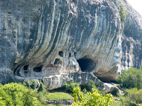 The architectural ensemble of the monastery consists of 23 rooms carved into the rock, including one cave temple. In the late 1970s - early 1980s. were held here archaeological research. The monastery looks like a one-time complex, without traces of significant repairs and rebuilding. Most likely, the monastery was founded in the XIV-XV centuries. on the northern border of the Principality of Theodoro. Modern inhabitants adapt the cave premises for the needs of monastic life - they make partitions, additional extensions, which does not always favorably affect the safety of the skete, which is an object of cultural heritage of national importance.
  Myra Lycian(Türkiye)

 Myra Lycian is an ancient city (modern name - Demre), lost between the eras and peoples that once inhabited this land.
  The Lycians, an Indo-European people who inhabited the southwestern part of Anatolia, belong to the number of insufficiently explored peoples of antiquity. This area, according to the inscriptions in the Lycian language, called Termilla, was inhabited for several thousand years BC.
  Mira itself was founded around the 5th century BC, and one of the attractions of the city is the famous rock burials - the tombs of the ancient Lycians carved into the rock.
  They are located on a sheer cut of the rock, which is literally dotted with these "caves".
  It was the custom of the Lycians to bury the dead in elevated places, as it was supposed that this would help them get to heaven. Each tomb from the outside was magnificently decorated with bas-reliefs and carvings, by which one can determine what the deceased did during his lifetime ... And next to rock tombs there is a Roman theater whose architecture and especially the beauty of the sculptural bas-reliefs speak of the excellent artistic taste of local masters.
 Vardzia and Uplistsikhe (Georgia) One of the most interesting sights of Georgia is the cave city of Vardzia. ancient building is a whole complex of corridors and rooms, carved into the rock almost a thousand years ago. The cave city is located in the south of Georgia, just 6 kilometers from the border with Turkey. The history of Vardzia begins at the end of the 12th century.
  Vardzia is a real underground city with many tunnels, stairs and alleys. Inside the rock, there was a place not only for the monastery, but also for several libraries, baths and many residential buildings. A real ant!
 In total, there are over 600 different rooms in Vardzia, which were stretched along the mountain for a distance of more than a kilometer, and the entire underground complex goes into the depth of the rock by 50 meters! In total, there are 13 floors in the cave city, and water supply is connected to each.
  In the event of an attack by enemies, up to 20 thousand people could hide in the fortress city at the same time, and thanks to three secret passages the defenders could inflict unexpected blows on the enemy forces.
  For a long time the cave city was abandoned, but at the end of the last century Vardzia was restored again, and the monastic life resumed in it. On this moment about 10-15 monks live in the monastery of the ancient city.
  Uplistsikhe 10 km from Gori, on the banks of the Kura River, there is one of the rarest monuments in the world - the ancient city-fortress Uplistsikhe, carved into the volcanic rocks of the Kvernaki ridge. Uplistsikhe - literally: the fortress of the lord; one of political centers Eastern Georgia of Antiquity.
  Rock structures here belong to very ancient pre-antique and antique periods. Part of the complex of the pre-Hellenistic period and quite accurately dates back to the 8th-5th centuries. BC e., the part is much older. It was a large pagan center, and after the adoption of Christianity by Georgia in the 4th century, by the 9th century it became one of the most important cities in the country. It was in the 9th century that a Christian brick church-basilica was built on the site of the former pagan temple of the Sun.
  Not far from the church, an altar of the 4th-5th centuries has been preserved. BC. and a cross carved in stone from the early Christian period. A wide road carved in stone leads to the city from the river. Streets equipped with a sewerage system diverge from the center from the square.
  Residential and utility rooms, wine storages, fragments of fortress walls and temples of the 6th-7th and 10th-11th centuries, a secret underground passage leading to the river, as well as deep 8-meter prison wells (6th-8th centuries) have been preserved. Among other unique exhibits, you can see the 8,000 year old wine press. This is the oldest winery in the world that has survived to this day. Cave city of Arbel (Israel) Arbel is a place in the Galilee. Natural beauty the Arbel Valley blends beautifully with richest history this edge. Mount Arbel - rises 380 meters above the Kinneret lake and 180 meters above sea level. From the rocks of the mountain, the spring of Arbel springs. At the foot of Mount Arbel - is Wadi Hamam, which means "Creek of pigeons" in translation. Many pigeons hide among the rocks, in caves.
  The sheer cliffs that surround the river are dotted along their entire length on both sides with once-inhabited caves.
  The fortification is a group of caves located in three tiers, connected by stairs and passages. Here and there we find storage facilities and water tanks. These structures are always plastered from the inside. There must have been a rainwater harvesting system. Going down the mountain along the most beautiful hiking route, tourists find themselves in the ruins of a fortress carved into a sheer rock; there, in the caves, armed rebels who rebelled against Herod the Great in 39 BC found their shelter. The Romans could not cope with them for a long time, until they lowered large wooden cages with soldiers from the mountain on cables, and only then destroyed the rebels. In subsequent centuries, the inhabitants of Galilee hid there. The natural impregnability of the caves was complemented by completed walls, making the cave fortress a very tough nut to crack for the besiegers. Traces of a later completion of the 16th-17th centuries are clearly visible. These works were carried out here by order of the Druze rulers from the Man dynasty, who owned the area during the Turkish Empire. The fortress is badly destroyed and this gives a peculiar charm to a walk through it.
  Matera (Italy)
 The city of Matera, Italy - the oldest locality in the south of the country, located in the region of Basilicata and is the best preserved example of a cave settlement. In terms of value for world science and culture, Matera can be ranked first among all such settlements in the Mediterranean.
 The peculiarity of this city, in which life is uniquely adapted to the local landscape, is that the first settlements here date back to the Paleolithic times.
 In 1993, the city of Matera (Italy) was listed by UNESCO as a World Cultural Heritage Site. On a city tour, you can see seemingly fantastic cave houses, cut directly into the thickness of the rock and called sassi (“stones”). According to scientists, the age of the most ancient Sassi is seven millennia. There are also more “younger” buildings here, the time of the construction of which is evidenced by churches built presumably in the 6th century.
  The walls and ceilings of some churches in this "cave" city are decorated with frescoes from the 11th and 12th centuries that have survived to this day. Much of Mel Gibson's film The Passion of the Christ was filmed in and around Matera. Uchisar in Cappadocia (Türkiye)
 Unique mountains volcanic origin cover the entire area of Cappadocia. These are sedimentary tuff rocks, they are quite easy to process, which allowed the locals to cut houses into them and create entire cave settlements. The first such dwellings appeared here several thousand years ago. One of the most populated villages cave type is Uchisar. Although most of the modern inhabitants have already managed to move into new comfortable houses, the living quarters cut in the caves still have their own residents. Some caves are used as warehouses and storages, but people live in others. Many cave apartments have modern brick outbuildings. The owners of apartments cut into the rocks willingly show them to tourists, sell souvenirs, which is a kind of tourist business for them. Near the ancient cave village, modern houses peacefully coexist.
  Tsaparang in Tibet 250 km from the foot of Mount Kailash, on a huge plateau, on the banks of the Sutlej River, lie the majestic ruins of the once powerful kingdom of Guge.
  The ancient ruins lie surrounded by yellow-brown rocks pitted with erosion and time, and the whole area is a huge lifeless desert.
  On the once busy road, in ancient times connecting Tibet with India and Turkestan, there were trade caravans and pilgrims following to Kailash.
  The Kingdom of Guge occupies territory along the banks of the upper Sutlej in western Tibet from the Kyunglung Valley (Garuda Valley) to the Indian border. The entire area of the Guge Kingdom is a complex of canyons bizarrely eroded into ancient red sandstone rocks.
  In ancient sources, the first information about populated cities in this area date back to 2800 BC. Tsaparang is the ruined capital of the ancient kingdom of Guge. In 1685, Tsaparang was conquered by the Muslims. The city was severely damaged. But especially serious destruction was inflicted on the city during the reign of Mao Zedong during the Cultural Revolution in China: many temples, statues and buildings were destroyed. cave temples in india Caves of Ellora
  Considered the largest in India, the complex of cave temples and monasteries of Ellora is located 30 km northwest of the city of Aurangabad, the center of the district of the same name in the state of Maharashtra. All caves of Ellora are carved into a low basalt cliff.

 From the point of view of dating the time of the creation of individual temples and monasteries, Ellora is probably one of the most problematic objects among all the cave structures of India for scientists.

 Ajanta caves
  Ajanta caves are carved into sheer granite rocks, in a gorge 22 m high. Temples were carved into the rocks for several centuries - in the 3rd-7th centuries. These famous caves preserve some of the finest masterpieces of Buddhist art in India. Ajanta is located in the Indian state of Maharashtra and has been on the list since 1983. world heritage UNESCO. The caves were discovered by accident in 1819. One English officer, hunting in the mountains, chasing a tiger, accidentally noticed the vague outlines of the caves.
  Paintings and murals are placed throughout the cave, except for the floor. In some places, the frescoes have been destroyed due to human intervention, so in many areas only fragments have survived.
  Exploration of the Ajanta caves continues to this day, but there are still many mysterious moments in their history. For example, it is not clear how artists could paint in semi-darkness; the mystery of luminous colors has not been revealed either. Today there is an art museum here. Ajanta painting is a unique encyclopedia that represents all social strata of Indian society (from the ruler to the beggar). There are stories about the numerous peoples who inhabited India, about important moments in its history.
  People, gods, flowers, animals look from different corners Ajanta, tell about something, teach, sing and dance, and call to join the holiday, and take them away to the heavenly distances to the sounds of nature. This is the bright message of the ancient masters, as if trying to say: life is priceless, and everything in the world is interconnected - people, gods and animals, heaven and earth.
 Elephanta Caves The Elephanta Caves are located in the central part of Elephanta Island near the city of Mumbai. The so-called City of Caves contains a large collection of rock art dedicated to the cult of the god Shiva. In 1987, the cave temples on Elephanta Island were included in the list of UNESCO World Heritage Sites. The most impressive among these monuments of the 7th and 8th centuries. - a complex of ancient cave temples with huge sculptures inside. The main sight here is a five-meter massive bust of the three-headed Shiva, which embodies his incarnations as the Creator, Preserver and Destroyer. "Shiva Caves", these famous ancient caves of Elephanta Island, are carved into the rock, constituting a sacred temple complex dedicated to god Shiva. Mesa Verde(USA) Mesa Verde is the name of the plateau and the national park located on it, not the cave city. How the Anasazi Indians, the ancestors of the Pueblos, called their settlements, no one will ever know. Actually, the settlements themselves would have remained unknown if not for the persistence of historians and archaeologists. For six hundred years from the 13th century, when the Anasazi mysteriously disappeared from the area, until the 19th century, when exploration of the area began, no human foot had set foot on Mesa Verde.
  Until now, a trail of mystery stretches behind the plateau and cave settlements. But it is known for certain that the Anasazi architecture is the first example of the construction of "apartment" houses in America: the rock deo-retz in Mesa Verde has about a hundred different rooms.
  The palace expands the interpretation of the term "cave city": it is not a system of caves used for living, but a full-fledged building, entirely built inside a huge grotto, above a rocky ledge.
  Life in Masa Verde was not easy: from their rocky houses on a plateau where agriculture was carried out, the Indians got out on rope or wooden ladders that swung over the abyss.
 Cave city of Kandovan (Iran)
 Located in the remote northwestern part of Iran, the village of Kandovan is known not only for the beauty of the surrounding nature, but also for the unique housing of the locals.
  Most of the houses here are carved into cone-shaped caves formed by volcanic lava and ash. The general landscape resembles a giant colony of termites. The people of Kandovan claim that their village is over 700 years old.
 Over the years, people have expanded their dwellings. Now the caves are divided into several floors, they contain rooms such as sheds, closets, cost for animals.
 Some even have porches, windows and doors, as well as flights of stairs carved into the rocks. Caves are among the most energy-efficient dwellings in the world, providing adequate insulation in winter and heat protection in summer.
 Sigiriya(Sri Lanka)
 Sigiriya is an ancient walled city built on a rock. Sigiriya or lion rock- this is the main asset of Sri Lanka, the most valuable architectural and cultural monument. The rock itself was formed from the lava of a large volcano, which has long ceased to exist. An amazing landscape opens up from a 200-meter cliff: picturesque gardens surrounding the mountain stretch for miles.
  The history of the Lion Rock begins in the 5th century BC, around this time a Buddhist monastery appeared here. This temple ceased to exist for only 18 years: from 477 to 495, and then was restored again and lasted until the end of the 14th century. The period of development of Sigiriya falls on the period of the reign of King Kassapa (477 - 495 years). It was during this short period of time that the rock was transformed into a complex city with palaces, temples, gardens, fountains and defensive structures.
  The name "Lion Rock" also appeared during the reign of Kassapa. The architects of Sigiriya brought to life a grandiose idea - the central entrance to the city was guarded by a huge lion carved from the rock, and in order to go inside it was necessary to go through the mouth of a stone beast. Unfortunately, only the paws of a lion have "survived" to this day, but they also look very impressive.
  Bamiyan (Afghanistan)
 At one time, the province of Bamiyan, located 225 miles from Kabul, attracted many tourists. The north of the valley is known for huge mysterious Buddha statues carved into the rocks. One of them, 55 m high, was the largest Buddha statue in the world. During the reign of Kanishka the Great, Bamiyan was a significant center of Buddhism. The sculptures of the deity, and the territory itself, were sacred. The priests created many cells here, where they led round holes in the rocks.
  The wars that have been going on in Afghanistan since 1980 and up to the present have caused significant damage to Bamiyan and the Buddhist monastery located in the province. Since October 1994, the Taliban - Islamic fundamentalists - have destroyed many sculptures, images and other artifacts in Bamiyan. The Taliban forces deliberately blew up the Buddha statues, destroying the main pride of the cave complex.
  Yungang Cave Temple Complex(China)
 A complex of 252 man-made caves 16 km southeast of the Chinese city of Datong, Shanxi province. Contains up to 51,000 Buddha images, some of which reach 17 meters in height.
  Most of the cave temples were built between 460 and 525 BC. n. e., when Chinese Buddhism experienced its first flowering.
  Yungang Grottoes are carved into the rock from porous material. They stretched for 1 km from east to west. In December 2001, the Yungang cave-temple complex was included in the "List of World Cultural and Natural Heritage".
  Unlike natural caves Reed Flute, where only magnificent lighting is man-made, shading the beauty underworld, Yungang cave grottoes are completely the work of human hands. One has only to imagine how much work would be expended in order to unique place appeared, as you involuntarily imbued with respect and genuine admiration for the talents of the ancient masters. Matmata(Tunisia) Tourists who have been among the desert hills of Matmata in the central part of the south of Tunisia are shocked by the inspired exoticism of the "lunar landscape" of these places. Millions of inhabitants of our planet saw them, not suspecting that this is Tunisia, because George Lucas filmed Star Wars here, and Steven Spielberg filmed Indiana Jones: Raiders of the Lost Ark.
  But the main attraction of Matmata is the Berber dwellings. The houses of the Matmata Berbers are more like fox holes than caves - they have rounded entrances and branch inside the local breed. Often, fish and palms are depicted on the doorposts - protective symbols of the Berbers. Entering the "house", you find yourself in a spacious courtyard under open sky(actually, this is not a hole yet), but cave rooms have already been dug out of it in different directions - bedrooms, living rooms, children's rooms and pantries.
  In the local soft rock, it is easier to build dwellings from the inside than to build houses out of it from the outside. Even in the most sizzling heat inside the house is not hot. In winter, the walls perfectly keep heat, and the dwelling can be heated no worse than an ordinary apartment.
  The Tunisian cave city has been really popular among tourists since one of the caves "starred" as the home of Luke Skywalker in Star Wars.
Among the numerous attractions of the Crimea, it is impossible not to notice the cave cities and cave monasteries. These unique architectural and historical monuments, concentrated in the southwestern part of Crimea, can be compared in their historical significance and value with medieval castles Europe. Having seen a lot in their lifetime, they silently keep numerous secrets and attract thousands of travelers with their mysteriousness.
The definition of "cave cities" is conditional, because people lived in ground buildings erected on impregnable rock masses. It arose due to the erroneous assumption that people lived here in caves carved into the rocks. This initial idea was also facilitated by the fact that it was the cave part of the former fortress cities that was preserved in the best way, in contrast to the ground buildings that were almost destroyed by enemies and time. Although such a theory was rejected in the course of further research of cave cities, this name was assigned to the deserted settlements on giant sheer cliffs.
The cave cities of Crimea can be called a kind of analogue of medieval European castles. These are real fortress cities, which were specially built on hard-to-reach or completely impregnable rocks, because it was dangerous to live in the valleys due to the constant raids of nomads. It can be said that nature itself has successfully taken care of the protection and shelter from enemies of the inhabitants of such fortifications.
Cave monasteries in the Crimea arose in the Middle Ages for almost the same reason as fortified cities - for shelter from enemies. Fleeing from their pursuers, not wanting to obey the Gentiles, and striving to preserve Orthodox traditions, the monks erected their cave temples in limestone rocks, which were easy to work with.
The massive mesas of the Inner Ridge of the Crimean Mountains, stretching from Simferopol to Sevastopol, became the place of origin of the cave cities and monasteries of Crimea, but most of these rock structures are concentrated in the Bakhchisarai region. It is from Bakhchisaray that it is convenient to start excursions in Crimea with the aim of visiting the most famous cave cities, in which residential and utility buildings carved into the rocks, as well as the ruins of ground buildings, and cave monasteries, many of which are still active temples, are well preserved.
The most visited due to its convenient location, the cave city of Chufut-Kale is located right outside the outskirts of the old part of the city of Bakhchisarai. Here you can not only visit the numerous artificial caves of the Crimea, but also see the preserved buildings different centuries, including the Karaite kenas and the mausoleum of Dzhanyke-Khanym. A tour of Chufut-Kale is an immersion in the past of Crimea. Founded in the VI century, the fortification, over the years of its existence, managed to serve as a home for many peoples, and even at one time was the capital of the Crimean Khanate. Chufut-Kale is of particular historical value, because the paths of different peoples crossed here, and the cave city itself can be called the crossroads of 3 religions.
On the way from Bakhchisaray to Chufut-Kale, you can visit the Holy Assumption Cave Monastery - one of the most famous shrines of Crimea. Located in sheer cliffs, the Orthodox church is a large-scale monastic complex, which includes not only religious, but also outbuildings. This cave monastery is still active and is one of the most popular Crimean places among pilgrims.
 |
Another well-known ancient temple of the Bakhchisarai region is the cave monastery of Theodore Stratilatlocated inside a spacious natural grotto in the Belbek Valley. In total, there are 22 caves here, some of them have niches carved into the rocks with tombs. This cave monastery is one of the most revered, because it is believed that the relics of saints were located here. In 2003, work began on the restoration of the dilapidated monastery complex, and now church bells are ringing again on the territory of the Theodore Stratilates monastery, and divine services are being held.
 |
To the south-east of Bakhchisarai there are two more cave towns, no less famous and popular among lovers of hiking and exciting excursions - Kachi-Kalyon and Tepe-Kermen. It will not be difficult to visit these sights of Crimea in one day, because they are located in close proximity to each other.
Kachi-Kalyon is interesting as a settlement of winemakers, and Tepe-Kermen - as a cave city, more precisely, even a fortress on a hill, in which local cattle breeders took refuge from the raids of nomads.
The settlement of Kachi-Kalyon arose as early as the 6th century, while the cave monastery appeared here only in the Middle Ages, and the surviving frescoes and the huge cross, noticeable when approaching the rock mass, remind of it, for which this cave city of Crimea received its name meaning "crusade ship". Cells carved into the rocks, Orthodox churches and a cave temple have been preserved here. If Kachi-Kalyon preserved mainly temple buildings, then Tepe-Kermen is dominated by economic caves.
 |
 |
| Rock of Kachi-Kalyon - general view of the cave city |
Although it is quite possible, it is still not worth limiting the sightseeing of these sights in one day, because in their vicinity there are no less curious objects of antiquity. They include Tash-Air with ancient petroglyphs and a few ruins of the ancient buildings of the cave city of the 10th century. Kyz-Kermen, which in the Middle Ages was one of the important trade and craft centers of this region.
Eski-Kermen is considered one of the best-preserved cave cities in Crimea. In its vicinity is the largest number surviving cave monasteries, some of which, although not active, still attract tourists. These are the Shuldan cave monastery, and including several dilapidated temples of Chilter-Marmar - a monastery that functioned in the Middle Ages, but now has lost its significance, and the castle of Kyz-Kule (Maiden Tower), which is one of the important sentinel points of Eski-Kermen. Therefore, to study this area rich in historical monuments, you can even devote more than one day.
The cave city of Eski-Kermen is located on sheer cliffs, looking at which, you perfectly understand why it was able to be so well preserved.
From the Kyz-Kule watchtower, located to the west of the settlement of Eski-Kermen, you can admire a breathtaking panorama covering almost the entire foothills. Near the ruins of this ancient fortress there is a gorge with numerous caves, one of which is distinguished by the presence of amazing rock frescoes and is called the Temple of Donators.
Before reaching the village of Ternovka, you can notice a lot of caves carved in it on a rocky cliff surrounded by forest. They contain the cells of the Shuldan monastery, which arose here in the Middle Ages. This cave temple is formed by two rocky rooms, each of which contains up to 20 cells arranged in 2 tiers. Since 2003, the revival of this cave monastery has been carried out, and now a center for the rehabilitation of drug addicts is located on its territory.
Although most of the cave cities and monasteries of Crimea are located in the vicinity of Bakhchisaray, there are no less curious tourist sites of such a type . One of the most spectacular among them is the cave city of Mangup-Kale, located not far from Eski-Kermen. It impresses not only with the ruins of an ancient settlement, but also with a well-preserved medieval fortress, and the plateau itself, on which the ruins of the Mangup fortress are located, was the site of ancient people long before the formation of a fortification.
Not far from Mangup-Kale is Chelter-Koba - a cave monastery, which is a large-scale Orthodox complex in the rocks. Many cells are interconnected by corridors and stairs carved into the rocks.
No less impressive is the Inkerman cave monastery, located in the immediate vicinity of Sevastopol - a suburb of Inkerman. This is the oldest Orthodox monastery on the territory of the Crimea, operating to this day. The monastery is distinguished by the presence of many artificial caves and picturesque views from its cells. In the neighborhood are the ruins of the ancient fortress of Kalamita.
 |
The northernmost cave city of Crimea - Bakla lies away from most tourist routes. It is interesting for its many grottoes and ancient burial grounds. The cave city of Bakla arose around the 4th-5th centuries, and on its territory there were not only residential and household buildings, but also Orthodox rock churches. But only after the devastating raid of the Nogai army in the 13th century, all this has sunk into oblivion, leaving only a few traces of the former life in these places as a memory for posterity.
A visit to the cave cities and monasteries of the Crimea allows you to closely come into contact with the history of the peninsula. This is a great opportunity to see ancient cave drawings and the first Christian frescoes, the ruins of ancient cave monasteries and fortresses. In addition, you will have unforgettable impressions from the picturesque views of nature and the dizzying heights of sheer cliffs.
See photos of cave cities and monasteries of Crimea in our gallery
Page materials are based on an author's article by Skywriter13


