Federal highway "Kolyma": beauty and horror. The farthest corners of the Kolyma highway
This long-suffering road has many names. The modern official is the federal highway P504 "Kolyma". Before that, the M-56 highway. But much more it is known as the Kolyma highway, the Kolyma tract and the "road on the bones."
It really exists - a giant transport artery 2032 km long, laid on the permafrost between Yakutsk and Magadan. 1197 km - Yakut, 835 km - Magadan. At the same time, Kolyma is not even the record holder in terms of length among federal highways- it is several tens of kilometers ahead of the Amur and Ural highways. The prefix "P" according to the modern classification means that the P504 road connects "only" administrative centers RF. Since 2003 zero kilometer moved to Yakutsk, but historically the route starts from Magadan, the city avenue named after Lenin, the former Kolyma highway, passes into it. It is here that the asphalted section of the road is located, the first 200 km. The coating on the remaining hundreds and hundreds of kilometers is mainly soil and gravel. On the pavement, it shakes, perhaps even more, but black dust swirls over many areas of the primer, even in winter. On its way, the route crosses many rivers, rivers and streams, and the main problem is the construction of bridges (ferry crossings operate in summer, ice crossings in winter). The absence of a key bridge across the Aldan River near the village of Khandyga has long been a byword. Its construction is planned to start only in 2014.
But those horrors that were recently told about the Kolyma highway are almost outdated today. Since 2008, the road has been considered year-round (when a “new” section of the road was opened between Kyubyume and Kadykchan via Ust-Nera). True, the off-season is still difficult to call a pleasant time to travel, but in winter and summer average speed movement approaching 80 km/h. Of course, "Kolyma" is not a highway European level, like Chita - Khabarovsk after Putin's visit, but not the same attraction for extreme people, for the sake of which people went to Kolyma even from Moscow.
The road, vital for the whole region, is slowly being improved. The previously impassable section of Kyubyume-Selerikan was repaired, bridges across the Bolshoy Selerikan, Elga, Brungade rivers, the Deering-Yuryakh stream and others were put into operation. Active work is underway on the most difficult section of the road - from Ust-Nera to Khandyga. Until recently, rare cars were moving in the middle of the track at a snail's pace, and now even the legendary clamps, where two cars could hardly pass, have been expanded. The views from the road are simply magnificent, but you can’t be distracted and relaxed, especially in winter - you can often see broken trucks on icy sections of the route.
The Kolyma highway, of course, is not, but by the standards of such a remote and harsh region as the northeast of Russia, it is quite popular with travelers. In summer, with favorable weather conditions the entire "Kolyma" can be driven even in a passenger car, albeit with adventures. Other options are hitchhiking, which is not very difficult here (almost everyone stops), or public transport. From Magadan to Susuman goes scheduled bus(about 2,000 rubles), in other areas, travelers are collected from local hotels by "taxi", however, you will have to fork out a lot for their services. So, in winter, travel from Yakutsk to Oymyakon (the old section of the road) or from Ust-Nera to Susuman will cost 5,000 rubles. Some bargaining is appropriate, but you should not go too far.
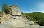
In addition to difficulties, on the Kolyma highway, the traveler is waiting for numerous natural attractions, strings of BELAZ trucks, traces of gold mining, and also, especially from the Kolyma River to Ust-Nera, many abandoned and half-dead villages. There are few colorful villages of Yakuts and Evens along the route itself, but if you wish, you can get to them if you have suitable transport.
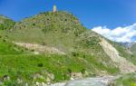
At the 140th kilometer after Khandyga there is special place, which is mentioned by all guidebooks on the track. This is the so-called "Magic Forest". The trees in it are hung with colorful patches and amulets. The Yakuts consider this forest sacred and call it the "Shaman Tree". Anyone passing by should stop and donate something to the local deities - even just a coin. There is another attraction in this forest: a stream that does not freeze even in the most severe frost. The water in it is very tasty and, they say, can remain fresh for more than one month. Although there are quite a few other non-freezing streams in these parts.
Old road to the Pole of Cold
About the old section of the Kolyma highway, the segment between Kyubyume and Kadykchan, it is worth telling separately. In the villages of Kyubyume (from the side of Yakutsk) and Kadykchan (from the side of Magadan), the Kolyma highway bifurcates into a new (Northern) and an old (Southern) road. It is clearly seen on the map that new road makes a big loop through Ust-Nera in the north, and the old one, built in the 1940s-50s, seems to be a convenient straight line between the two settlements. old road shorter than the new one by 200 km, moreover, it passes through the Oymyakon depression, where the famous “Pole of Cold”, the coldest inhabited place on the planet, is located. It is known as Oymyakon, in fact, these are three villages - Oymyakon, Tomtor and Uchyugey. On the obelisks in Tomtor and Oymyakon, the minimum temperatures recorded here are indicated: -71.2 ° С. Oymyakon is becoming more and more popular with tourists - in March, the Pole of Cold festival takes place here.
However, the short, straight road between Kyubyume and Kadykchan only looks tempting on a map. From the Yakut side, you can still drive along it, although old bridge across the river of the same name is destroyed, and a new one is promised to be delivered only in 2014. But the 100-kilometer section from Tomtor to Magadan region can be considered one of the most extreme: the road services have not been watching him for fifteen years. An abandoned site, eroded soil, rivers without bridges - even an all-terrain vehicle can get stuck here in the summer. But the more extreme, the more interesting: lovers of such adventures really appreciate this route.
Important
The Lena and Aldan rivers in summer can only be crossed by ferry crossing, in winter - on ice. There is no crossing in spring and autumn. The construction of the bridge across the Aldan is planned to start in 2014. The construction of a combined (railway-road) bridge across the Lena in the Yakutsk region is also planned - it will connect the existing and under construction latitudinal highways Kolyma, Vilyui and Amga with the Berkakit-Tommot-Yakutsk meridional railway under construction.
Items medical care and there are no traffic police posts on the Kolyma highway. Tire stations are found only on the initial stretch Kolyma highway, from Yakutsk to Khandyga.
cellular now available in all major cities. Often this The best way make a call because the long-distance wired connection often does not work or is unstable.
Gas stations are located in the following settlements: Palatka, Atka, Strelka, Yagodnoye, Berelekh, Artyk, Ust-Nera, Churapcha, Ytyk-Kyuel, Khandyga, Teply Klyuch, Kyubyume. In the village of Ust-Nera, the cost of fuel is the highest, since it is brought from Magadan.
Hitchhiking along the Kolyma highway is very popular. Almost all drivers stop. Need to find an even open space, where the voting person is clearly visible from a distance. In the dark, you will also have to make a fire. In winter (and winter hitchhiking is even more popular than summer), it is by no means recommended to travel alone, without experience in such travel and special equipment. In Yakutia, frosts down to -50 ° C are considered the climatic norm, -60 ° C is also not uncommon. It is imperative to stick to residential villages, where no one will refuse help, they will always let you warm up, feed you and leave you to spend the night. The old section of the road Kadykchan - Oymyakon - Kyubyume, extreme in summer, is generally impassable in winter.
Feel free to ask for help - the locals will help any traveler in trouble. If you run into problems along the way, many passing vehicles will stop and provide the necessary assistance, but in some areas with less traffic, you can wait an hour or more.
You should be prepared to meet wild animals - mostly bears. In autumn, in hotels, you can run into robbers and swindlers who are hunting for the tight wallets of artel workers returning from their shift.
Local Features
The highway with the M56 index officially no longer exists - recently its sections were divided into P504 Kolyma and A360 Lena. The latter is often called the Amur-Yakutsk (automobile) highway. "Lena" goes south from Yakutsk to Never in the Amur Region. At the same time, the docking with the Kolyma highway is not in Yakutsk, but in Nizhny Bestyakh.
Story
Roads (tracts) existed in these parts in the 18th century. But the construction of the Kolyma tract began only in 1932. The starting point was Magadan, then still a village on the coast Sea of Okhotsk. The need to build a transport highway was obvious: the industrial development of the richest deposits of gold, silver, tin and coal began in Kolyma and Yakutia, and it was supposed to export valuable cargo through the Nagaev Bay of Magadan - the most convenient port on the Sea of Okhotsk.
One snag: the route had to pass through permafrost regions, cross many rivers and streams, cross mountains and hills. This is now the Oymyakon Pole of Cold - entertainment for well-equipped tourists, and then these were remote villages at the same temperature, up to -70 ° C. But in Stalin's time, the question of "who and how" will build in such conditions was solved simply.
In 1931, the first batch of the future labor force arrived in Magadan: prisoners, "enemies of the people." Of course, they also attracted civilians - engineers, builders - but the proportions are striking: in Dalstroy (the organization that in 1931 was responsible for the construction highway) there were more than 44 thousand convicts and 5700 civilians.
The roads were designed unpaved, 3rd class, with a clearing width of 30 m, with artificial structures of the 2nd class under the load of an 8-ton car. Already in the summer of 1932, the first 30 km of the Kolyma highway and 90 km of the winter road were put into operation. The remaining 1042 km to Ust-Nera were built until 1953.
On the regional portal Kolyma.Ru there is an exhaustive description of the construction process: “In the 30s. 20th century there was practically no special road-building equipment for laying roads in Kolyma. Therefore, the development of the soil was carried out by the muscular strength of the prisoners - a pick, a pickaxe, a shovel, and the haulage was carried out by wheelbarrows and grabbars at a distance of tens to hundreds of meters. Rocks were developed by explosion. The forest was brought in by horses. For transportation of soil in winter conditions, ice paths were used, along which wheelbarrows were rolled (a ski was put in place of the wheel). In addition, overpasses, sledges, cranes were used. But the work of the prisoners was hard labor. The working day began at sunrise and lasted 12–14 hours in summer, and in winter the entire daylight hours. Here is what the newspaper Sovetskaya Kolyma wrote on January 6, 1936 about the labor heroism of the prisoners: “From Strelka to Khatynnakh, from the Disputable to the Duck camp, the strike teams were given passage in 1935, only genuine enthusiasm helped the strikers overcome the icy slopes, swamps, mari, permafrost, quicksand."
Road engineers followed the terrain as much as possible, so there are still many curved sections on the track. In the early years, cargo was transported along the Kolyma highway, passengers were hardly taken - according to the instructions of 1933, only one car was allocated for them in a convoy. People were given special insulation for travel - sheepskin coats and so on. This concerned free passengers, not "labor force".
The construction was all-season, and the Kolyma climate literally “dead horses”: according to documents, in one winter of 1931-32, more than 2,000 horses died, delivering goods to local mines. By 1941, the road had been completed to Susuman. During the war, construction progressed more slowly, but did not stop, moreover, in 1943, rich gold deposits were found in the Indigirka basin. However, the most difficult geological and climatic conditions made it possible to complete the laying of the remaining 1042 kilometers of the route to Ust-Nera only by 1953.
For comparison - now, if available modern technologies, construction machinery and equipment, construction and repair are carried out at a snail's pace. And this is almost normal, given the conditions. Abnormal is just the speed with which the track was laid in Stalin's time. The Kolyma road will be called "the road of death", "the road on the bones" for a long time to come. Numerous monuments, to which local population treats with unostentatious respect, and genuine remnants of the camp past: dilapidated wooden loaders and dilapidated fences along the road. In 2008, upon completion of the construction of a new section of the Kyubyume-Kadykchan road, a memorial stele "Kolyma rose from tears" was opened on the hill at the entrance to Ust-Nera.
Many wrote about the Kolyma highway. Brighter than others - Varlam Shalamov, a former Kolyma prisoner: “The track is the artery and the main nerve of the Kolyma. Loads of equipment are constantly moving in both directions - without protection, products with an obligatory escort: fugitives attack, rob. Yes, and from the driver and supply agent, the convoy, although unreliable, is still protection - it can prevent theft ... Immediately the prisoners are taken in clean, orderly parties up into the taiga, and in a dirty heap of garbage - from above, back from the taiga. Here are the detectives-operatives who catch the fugitives. And the fugitives themselves - often in military uniform. Here the authorities ride in ZISs - the masters of the life and death of all these people.
To see how the Ust-Srednekanskaya HPP is being built.
2. Sokol Airport. The beginning of our journey to the center of the Magadan region. It was not possible to visit Magadan itself - it is located away from the Sokol airport and far from our route.
To get to the station, we had to overcome 500 km. along the federal highway M56 "Kolyma".
3. For most people, the mention of Kolyma is associated exclusively with places of deprivation of liberty.
In fact, there is only one prison in the Magadan region today.
It is located in the village of Uptar, and this is not even Kolyma. 
4. Federal highway M56 "Kolyma" connects Magadan and Yakutsk.
The historical name is the Kolyma highway, or the Kolyma tract. 
5. In the popular mind, the Kolyma Highway is a long-suffering road built by prisoners on the edge of the earth, and at the same time extremely romantic. 
6. It arose due to two circumstances: the discovery in Kolyma and Yakutia of the richest deposits of gold, silver, tin, coal and the creation of the Gulag system. 
7. Belaz on a halt. 
8. There are sections with asphalt, usually near cities. 
9. Tractors don't need asphalt. A trace from a tractor left on a hill. 
10. The Kolyma track is one of the ten most difficult tracks in the world. 
11. In addition to difficulties, picturesque landscapes and numerous natural attractions still await the traveler on the Kolyma highway. 
12. Some of the settlements marked on the map no longer exist. 
13. Steep passes, abandoned areas washed out by heavy rains, rivers without bridges, dead, crumbling villages, an unusually harsh climate - this is Kolyma. 
14.
15.
16.
17. Meet on the way interesting names settlements and passes. 
18. But if you sit here, you can wash some gold))) 
19. Hey! People!... 
20. Graders level the road. 
21. Dorozhnikov was guarded by a faithful dog. 
22. In places, a rolled primer is no worse than asphalt. 
23. But it’s better not to get close to this object, they wash the gold, shoot without warning. 
24.
25. Turn to the Ust-Srednekanskaya HPP. 
26. A stream that turns into a river in spring. 
27. Descent from the pass. 
28. Power transmission towers and track from the tractor that dragged them there. At first I thought it was a helicopter.
But the tractor is cheaper, as they explained to me later 
29. The weather changed every hundred kilometers. 
30. Forty minutes later, as we turned off the M-65 highway, we saw the Kolyma River in all its glory. 
Perhaps one of the most memorable business trips for my journalistic activities. And it took place thanks to an incredible adventure, which was conceived and carefully planned by the team of the television production company LAV Productions with the support of Russian geographical society and Skoda. The goal is to break the Guinness record in the nomination "The longest non-circular route within the borders of one country." In the original version, the participants had to travel 35,000 km, thus surpassing the achievement of Chinese travelers. But while they were preparing, the Indians seized the palm, covering this distance by a couple of thousand kilometers. And the route had to be extended.
Automarathon "Secret Russia" started in the city of Nikel, on the border Murmansk region with Norway. Participants in Skoda Yeti cars had to cross our country from west to east, through eight time zones and 61 regions. By the last stage - from Yakutsk to Magadan - I was lucky enough to join.
From Sakha
The Kolyma highway does not start in Yakutsk, but on the opposite bank of the Lena, in the village of Nizhny Bestyakh. In the warm season, a ferry goes here from the capital of the Republic of Sakha (Yakutia), in winter they freeze the winter road. In the off-season, until the ice drift stops, road traffic is interrupted, and nearby settlements are cut off from big city. The project of a 19-kilometer bridge across the Lena has been in existence for a long time. Rumor has it that even the money for its construction was included in the budget ... But the Crimea happened - and all the forces and means were thrown into the construction of another bridge.
A few tens of kilometers after the crossing, the asphalt ends. And he will appear only in front of Magadan. Two thousand kilometers of the Kolyma highway is a grader, a rolled mixture of crushed stone and clay with sand. Moreover, throughout the entire road, the surface changes from ideal - close to asphalt, on which you can safely go under a hundred, - to impassable, where the speed drops to walking speed, and Yeti, despite 180 mm of ground clearance, begin to mournfully scrape the bottom.
Terrible! And it's not about the condition of the road. On the contrary, we must pay tribute to the local road builders. With modest funds that the federal budget allocates for the maintenance of this route, and in super-severe climatic conditions they manage to keep the road in a passable, working condition, and they react to all cataclysms with cosmic speed. It makes you feel uncomfortable from another thought - that you are going ... on human bones. To hell with images - literally! When in the thirties of the last century the Kolyma highway was laid by the forces of prisoners, thousands of people were buried in an embankment. They were buried by their comrades with a pick and a shovel. Buried to stay alive. Indeed, for the unrecorded deceased, they continued to give out rations, which allowed those who still continued to fight for life to survive.
Stop! One of the cars has a punctured wheel. At first, even in joy - you can escape from heavy thoughts and warm up. But when a forced pit stop happens three times at a hundred kilometers, such fun quickly ceases to be enjoyable. Moreover, I was among those who slowed down the caravan, and twice. It is not for nothing that many private carriers become active when snow falls: it smooths out bumps and hinders flying stones.
Sharp stones threatening tires are not the only difficulty for the conquerors of Kolyma. Much more unpleasant is the dust that the car in front raises. In this plume you can see at best a few tens of meters ahead. This ride is exhausting. I would gladly exchange a couple of hundred of these nightmarish kilometers for a thousand on ordinary asphalt.
Through rivers, mountains and valleys
Another water obstacle on the way is Aldan. This is the right tributary of the Lena, and in the place where ferry crossing This river is also quite wide. When the bridge will appear here is unknown. But this federal highway is the only thread that connects the two major cities and is in fact the road of life for a few, but still settlements between them.
Such, for example, as Khandyga, where our group stayed for one of the overnight stays. Do not expect a colorful description of this village, founded in the late thirties of the last century as a camp site for the needs of a large construction site. On the day of our arrival, City Day was celebrated here, and we were strongly advised not to make an evening promenade. Therefore, my impressions were limited to a small room in a residential apartment (we didn’t even talk about a hotel), where the three of us spent the night with colleagues. Childhood memories of how we huddled nine meters in a communal apartment surfaced in my head. Returned to the past.
The village of Teply Klyuch is located 70 kilometers from Khandyga. It houses an airfield that was used during the war as a transshipment base for ferrying American Lend-Lease bombers from Alaska to the battlefield. For a long time the airfield did not work, but recently they began to fly from here passenger aircraft. Due to the lack of competition, tickets are expensive - a flight to Yakutsk, at a distance of less than 500 km, will cost 8,000 rubles. And not so long ago they asked for one and a half times more.
Beyond Teply Klyuch, water meadows gave way to landscapes of the Verkhoyansk Range. This Mountain chain stretches across Yakutia for 1200 km and consists of dozens of ridges, some of which are higher than 2000 meters. The path through the mountains starts from the Hare Loop pass. Perhaps one of the most beautiful places on the ground. And a little further are the two most dangerous places on this track - Yellow and Black clamps. These are sections of the route carved into the rock at a height of 120 meters above the Eastern Khandyga River. And they were cut down with pickaxes of prisoners, without the use of technology. The road here is extremely narrow - no wider than four meters, and this is not enough for two cars to pass. On the one hand - a mountain, on the other - an abyss. You can only miss an oncoming one by passing back to the nearest pocket. In addition, due to groundwater and ice, cars often slipped into the abyss. Apparently, the local aura was so accustomed to the constant deaths that it fed on during the construction of the track that it longed for more and more sacrifices.
However, dangerous clamps remained in the last century - already in the 2000s, these sections were expanded. Two trucks pass easily along their entire length, bumpers and new signs are installed. And we were driving along the already reconstructed section - one of the most comfortable and safe on the Kolyma highway.
Weather forecast
"Kolyma" - a route on which the time of arrival at a given point cannot be calculated with an accuracy of up to an hour. We were lucky that we did not run out of schedule, although there were prerequisites for this. We could hang out for a day in the village of Ust-Nera, approximately halfway between Yakutsk and Magadan. The road was washed away 300 kilometers from it, and fuel trucks could not pass in the direction of the village. Therefore, gasoline at gas stations was released strictly at 20 liters per car - and with such a margin it is dangerous to hit the road.
Thanks to the locals - helped out. And we, albeit with a two-hour delay, moved on. If we do not take this collapse into account, there is no particular shortage of fuel along the entire route. Gas stations, of course, are located at a decent distance from each other - between some of them several hundred kilometers. Do not expect convenient dispensers and roadside shops, as on other federal highways. Gasoline prices are slightly higher than the national average: for a liter of AI-95 they ask from 45 to 55 rubles.
It is better to ride in the rain: there is no dust curtain. True, dirt begins to fly from under the wheels - after an hour or two of driving, the cars become monotonous. Even stop signs are not visible. We have to stop to wash the glass and lighting equipment. But driving in such conditions is still much more comfortable.
In a kind of "protective coloring" we arrived in Susuman, located on the banks of the Berelekh River (Kolyma basin). In the 1930s, alluvial gold was found here in the local rivers, and in 1937, active construction of the village began with the help of GULAG prisoners. Now about 5,000 people live here, and the population is constantly decreasing. The Berelekh microdistrict on the outskirts of Susuman has almost completely died out - only a few houses remained residential.
While colleagues were fascinated by shooting buildings with gaping eye sockets, I ran into a local store. I spoke with the saleswoman. She turned out to be a chemistry teacher. In 2004, a few days before the start of the school year, an order was received local authorities about school closure. The kids were transferred to another one - in the center of Susuman, and the teaching staff was dismissed. Someone left for the mainland, someone found another job ... In parting, she treated me to local hothouse cucumbers. Delicious!
Berelyokh is not the only one dead city on the Kolyma highway. Behind last years their number has increased. People leave in search a better life, and the buildings remain at the mercy of local winds and frost. By the way, one of the most famous ghost towns on the route is Kadykchan. It arose during the war years as a working settlement at a coal mining enterprise. mine and residential buildings, of course, erected by prisoners, in whose ranks was the writer Varlam Shalamov.
On the way to Magadan, one becomes inexplicably sad. I want to turn around and drive the whole route again. And not only because many interesting objects remained uncovered. Kolyma has an anomalous attractive force. Once you visit these places, you will definitely come back here. And of their own free will.
The Kolyma highway is, in fact, what Magadan was created for. Magadan itself, as a city in this very corner of the map, was of no use to anyone - there were no even aboriginal camps there.
But a whole gold-bearing province was discovered a few hundred kilometers from the Okhotsk coast, which required large-scale industrial development. And industrial development assumed supply and repair base.
This is how the Kolyma route was built in the shortest possible time, connecting the most suitable for creating a deep-sea seaport bay; and the gold-mining region of the upper reaches of the Kolyma.
Today, the route branches into four parts - the main one - which goes to Ust-Nera-Yakutsk - that is, in fact, it connects Magadan with the mainland (there, by the way, there is another lapel - through Aldan, it functioned much earlier); Tenkinskaya (to Ust-Omchug); Omsukchanskaya (to the silver mine "Dukat") and Seimchanskaya - which used to be the main one.

Now a few photos from the track, where we eventually turn to Seymchan.
The road starts from the customs post. Yes, damn it, Magadan made the dream of the Black Sea pique vests come true and was declared a free city. But he paid for this with a customs barrier from the main country, which sometimes tends to cause considerable inconvenience to the inhabitants of the city and the people visiting it.


This is the abandoned Karamken mine.

This is the cafe "Donyshko" behind the abandoned Karamken mine. Outside.

Please note - a truck covered with striped fabric carries equipment for a group of four people.
And here is the "Donyshko" inside.

The concrete stretches for 100 km from Karamken, then a good two-lane primer begins.

Meeting.

Typical paintings along the way.


Apple pass. From here begins the Kolyma basin.

Settling of cars on Yablonev.

Dedushkina Lysina pass.


Atka village. From the abbreviated ATK - motor transport column. The column left, the village remained. Then the village left. Almost.


Canteen in Atka.


When the ground becomes hard. Part two. April 10th, 2016
federal highway"Kolyma". P504.
The vast majority of the inhabitants of central Russia, and especially the inhabitants of the main metropolitan areas, have an extremely poor idea of the life of the remote regions of the country. Single topic this life is transport accessibility, or more precisely inaccessibility. This is especially true of the North-East of the country. Now I'm talking only about terrestrial highways, which are practically absent, although other modes of transport are not properly developed here and the cost of local transportation is extremely high. The most important road here is the Yakutsk-Magadan highway. It stretches as a connecting chord for two thousand kilometers. Not many roads leave from it, leading to remote villages, and most of them are winter roads, that is, roads that exist only in winter. This road is also called the Kolyma highway, in its history there are very gloomy pages associated with the Gulag times. Times are now, fortunately, different, but even now this road requires its sacrifices. Although, in the past few years, road construction has been deployed here and many problem areas that used to be frankly dangerous are now not so scary. But the construction capacity is clearly not enough and many sections remain difficult. I have already had to pass here several times through all sections, starting from Yakutsk and ending with Magadan, now the Yakut part from Yakutsk to Ust-Nera is especially well known, which I experienced on myself both in summer and in winter time. It is quite possible that someday I will invite you to ride along this road and see everything with your own eyes, besides, there is amazing nature and landscapes, but so far I will show it only in photographs.

Most of the settlements of Yakutia are accessible by road only in winter, and this route makes it possible to serve at least some part of the territory year-round. But even this is relative, as long as there is no bridge across the Lena. In the spring, when the ice no longer holds, and the ferries still do not run, and at the beginning of winter, when the ice still does not hold, and the ferries no longer run, Yakutsk is cut off from the Kolyma highway. This is more than an urgent need for the republic and talks about construction have been going on for a long time, but so far nothing real has happened. This is especially true considering that Railway has almost arrived in Bestyakh, which is located opposite Yakutsk on the right bank of the Lena, and Yakutsk on the left. Yes, and the road to Neryungri and further south, to the main highways countries, also on the other side. The bridge is vital for Yakutsk and the republic as a whole. By the way, Lena is not the only one. big river, which the Kolyma highway crosses, there is also Aldan. There, too, there is an off-season period when the road is closed. But there is no talk about the bridge over the Aldan yet. Build through Lena.

Here, the road to Batagay departs from the Kolyma highway, and then you can get to Ust-Kuyga and Deputatsky. The fork is located approximately on the five hundredth kilometer of the route from Yakutsk, when the road finally enters mountain part. A relatively flat part lies between the Lena and Aldan, and then a little further than the village of Khandyga enters the mountains.

Orthodoxy came to Yakutia a long time ago, but this does not interfere with the preservation of traditions associated with the ancient beliefs of the people. Such places for sacrifices can be found not only somewhere in the mountains, but simply even on the road. Put pancakes, a cigarette or something else, you can go easy.

Here's another one Holy place on road. This stream does not freeze even in the most very coldy, you see coins at its bottom, these are also sacrifices. Of course, a car park is organized nearby and truckers often spend the night here.

Here you can also tie a ribbon.

The road is long and breakdowns are not uncommon, a punctured wheel is one of the options.

And here the tank has parted at the seam, we are trying to save diesel fuel as much as possible. Well, the tank is not the only one.

But the wheel or tank of the victim is small, the road takes and is much larger.

Black clamp - was once one of the most dangerous sections of the road. Now it's very well done and it's pretty safe here now.

But even now, people are dying on the Black Clamp. This accident happened not long ago.

Much here depends on the weather. A little snow fell and that's it, trucks can no longer crawl onto the pass, they line up, put chains on the wheels. This is the queue for the Brungandinsky Pass.


Olchansky pass near Ust-Nera, also a dangerous area.

I remember last year, after spending the night at a fork at the five hundredth kilometer, we got into a heavy snowfall and then we were able to drive only twenty kilometers in a day. It was full of cars like that standing across the road. I could not climb the hill, backed up, the trailer to the side and the situation is ready.

Naturally, everyone who is nearby has to help.

Mutual assistance on the track is a common occurrence.


The guy from Armavir smiles, but he understands that he is stuck here for a long time. His trailer, of course, was moved to the side, but you will have to wait until the weather improves and someone will drag him up this hill. Although there will be further slides, so it’s better not to meddle further for now.

This one also did not climb, but another time on ice and he was even more unlucky.

There are a lot of treacherous places here, where the road is narrow and took a little too much to the side when you pass with an oncoming one, right there and in a ditch. Then the pulling entertainment begins, there is a car and it lies entirely on its side.


There are not many places on the highway where you can refuel. This is the famous gas station on Kyubyum. Here the price is almost the same as in Yakutsk. This year, diesel fuel here cost 48 rubles, and in Ust-Nera it is already 55 rubles, so everyone who travels towards Magadan tries to fill up here. In addition, each has additional tanks. Have you ever heard such a term "Kolymbak", so it was invented in these parts. Behind the cabin, they make a special container of a very large volume, into which you can fill in so much diesel fuel that it can be enough for a very long flight.

Ust-Nera is a key settlement on the highway. The village is located almost in the middle of the route between Yakutsk and Magadan, and from here the winter road departs along the Indigirka to northern settlements Khonuu, White Mountain, Chokurdakh.

In winter, of course, the Kolyma highway is more difficult, but in summer it can be difficult to pass. I remember that we traveled from Yakutsk to Tomtor for three days. Flooding washed out the track in several places.

Then I had to look for workarounds.
The Kolyma highway, of course, is not a gift for drivers, but there is no other here. But for tourists or photo tourists it can be a very attractive object. Considering that in terms of landscape everything is very textured here, you can drive off the road and to the side to even more textured objects, and even in settlements there are many attractive things. So I'm wondering if I organize a tour here, will anyone go? It is possible and summer version and come up with a winter one.