The most salty lake in the world is the Dead Sea. The most salty lake in the world
In Russia, there are many salt lakes that are unique in their composition and healing properties. Almost every region has a similar reservoir, which has its own special history and is covered with legends. Salt lakes are always popular among vacationers.
Russian salt lakes are in no way inferior to the famous Dead Sea. Let us dwell in more detail on the features of several reservoirs rich in deposits of therapeutic mud and mineral salts.

The largest salt lake in Russia is Kulundinskoye. It is located in the Altai Territory and is even called local residents"Altai Sea". It is considered a slightly saline body of water (salinity is about 11%), after swimming in it, no plaque remains on the body. The diameter of Kulunda Lake is 35 km, so the shores are lost in the distance. In summer, the water temperature can warm up to +26 degrees.

Lake Tambukan is located near Pyatigorsk. At the bottom of the lake there are several tons of therapeutic mud, which is systematically mined for use in medicine and cosmetology. It is noteworthy that Tambukan Lake has an almost perfect oval shape.

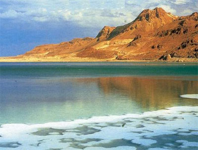
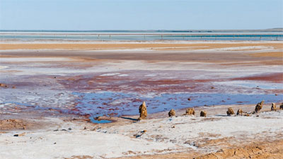
Baskunchak is located in Astrakhan region, slightly north of the Caspian Sea. It is divided into Upper, Lower and Middle Baskunchak. The reservoir is a kind of depression at the top salt mountain, thousands of meters deep into the earth. The area of the lake is 106 km², and its greatest depth is 3 meters. Salinity is 300%. About 1,500 tons of salt are extracted from the lake annually, which is 80% of the total production in the Russian Federation. The deposits of therapeutic mud successfully cure many diseases.

Elton - Europe's largest salt lake is one of the most interesting sights Volgograd region. The area of the reservoir is 152 km², the shape is close to a circle. It is self-planting, in the off-season it becomes a refuge for migratory birds. Salinity can range from 200 to 500%. The mineralization of Elton is twice that of the Dead Sea. Mineral salts give the water a golden-pink hue, which is why the name is translated as "golden lake".

Chany is the largest salt reservoir in Western Siberia and located in Novosibirsk region. Most of The lake is located in the forest-steppe. The area is 1500-2000 km². There is a legend that says about the presence in the reservoir giant snake devouring bathing people. Resting on the lake is not always safe because in bad weather rise high waves- There have been several deaths.

Bulukhta is the second largest salt lake after Elton in the Volgograd region. It is a bitter-salty drainless reservoir. The boundaries of the lake are constantly changing, the reservoir itself is extremely swampy, has a muddy bottom. Located on the banks of the reservoir rare bird, listed in the Red Book - Imperial Eagle.

Collapse - the reservoir is the main attraction of Sol-Iletsk. The lake is artificial. The concentration of salt in it exceeds 200 grams per liter of water. Because of useful properties water on the shore of the lake there are several health-improving institutions. Interestingly, the rhombuses depicted on the coat of arms of Sol-Iletsk are a reflection of the salt extracted from Lake Razval.
On Russian salt lakes you can not only relax, but also restore your health. As a rule, for some diseases, patients are prescribed not only medication, but also spa treatment. The beneficial effect of salt lakes on the human body, with the help of them, various skin diseases, gynecological, musculoskeletal diseases and others are treated.
P O CH E M U CH K A
There are several contenders for the title of the saltiest lake in the world. Let's take a closer look at these lakes, because each of them is unique in its own way.
1. Dead Sea
Perhaps the most famous contender. Although it is called the sea, in fact it is a lake, since it is endorheic, that is, it does not have access to the ocean.
The Dead Sea is located on the border between Israel and Jordan. It is quite small in size: 76 kilometers long and 18 kilometers wide. Its area is 810 km2, and its depth is about 370 m, and it is constantly decreasing. Only one flows into the Dead Sea major river- Jordan, as well as several small rivers and streams. For centuries, the Jordan has been bringing its waters here, which evaporate intensively - the temperature here rarely drops below 40 ° C - and the salts remain and accumulate. In addition to the waters of the Jordan River, the Dead Sea feeds a large number of mineral springs hitting on it south coast. As a result, the concentration of salts in the Dead Sea is, on average, 28%, and in some places reaches 33%. For comparison, the concentration of salts in the World Ocean is about 3-4%. Most fresh water("only" 24%) in the north of the Dead Sea - where the Jordan River flows into it. The further south, the saltier the water in the lake. At the southernmost tip, even salt pillars are formed from the drying supersaturated salt solution. One of them resembles in its outlines a female figure in a cloak and is called "Lot's wife". This name is closely connected with the biblical legend, according to which God decided to punish the cities of Sodom and Gomorrah, located in the Dead Sea region, because these cities were mired in debauchery. God warned the righteous Lot about this, ordering him to leave the city on the eve of its destruction, without stopping anywhere and without turning around. But the wife of the righteous, breaking the prohibition of the Lord, looked back, leaving, at her native walls, for which she was punished, turning into a pillar of salt).

Pillar of salt "Lot's wife"
The waters of the Dead Sea are actually dead, as its name says: there are no fish here, no algae grow; its shores are also lifeless. Even the surface of this lake does not resemble water - it is a thick, oily-looking liquid with a metallic sheen and yellowish-white flakes of salt in small places. However, it is not completely "dead": various salt-loving bacteria and even fungi live in its waters.
Dead Sea
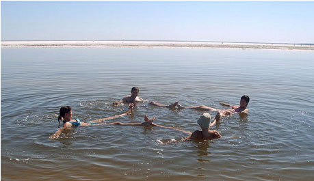
Due to such a high concentration of salts, it is impossible to drown in the Dead Sea. It is also impossible to swim or dive - a person can only swing on the surface of the Dead Sea water, like a float. You can safely stretch out with a book on the surface of this unique lake- thick dense brine will not let you drown. However, it corrodes the skin, and the slightest scratch, when this brine gets on it, begins to hurt. Therefore, swimming in the Dead Sea is the lot of exotic lovers or those who do it according to the doctor's prescription - the healing properties of these waters, as well as the Dead Sea mud, rich in bromine, potassium, sodium and iodine, have been known since the time of the biblical King Herod. Dead Sea water is good for treating skin and other diseases.

You can't drown in the Dead Sea
Coast Dead Sea is the most low place on the land of our planet and lies 400 meters below the level of the oceans.
2. Lake Don Juan
On the glacial continent of Antarctica, in the Wright Valley on the land of Victoria, another lake has been discovered that claims to be the palm for its salinity.

Location of Lake Don Juan
It was named not at all in honor of the famous womanizer, as it might seem at first glance, but in honor of the people who discovered it in 1961 - these were helicopter pilots Don Ro and John Hickey. It is quite small. Back in 1998, it was no more than 100 m deep, its length and width were 1 and 0.4 km, respectively. At the moment, the depth of the reservoir does not exceed 10 cm, and its size is 300 meters long and 100 meters wide. Water evaporates very quickly, but the lake does not dry up completely, thanks to underwater waters. Actually, this lake is a place where groundwater (underground) water comes out.

Lake Don Juan - view from space
The reason for the incredible salinity of the lake, as scientists suggest, is the high salt content in sedimentary rocks through which melt water from springs passes, feeding the lake. The air in the valley is extremely dry, and in such conditions the water evaporates strongly.

Lake Don Juan
Another reason for the interest of scientists in the lake is the possible similarity of conditions in its vicinity with the surface of Mars. It is believed that there are many lakes on Mars similar to Don Juan.
3. Lake Elton
Lake Elton (the name probably comes from the Mongolian "Altyn-Nor" - a gold mine) is located in Russia, in the Volgograd region, not far from the border with Kazakhstan. This is the largest mineral lake in Europe (152 km2). The depth of it amazing lake is only 5-7 cm in summer and up to 1.5 m in spring.

Lake Elton
The mineralization of Elton waters reaches 200-500 g/l, which is one and a half times more than that of the Dead Sea. Until 1882, salt was mined here. In 1910, a sanatorium was built on the shores of Lake Elton. Since 2001, Lake Elton has been a part of natural park"Elton".
The shape of the lake is almost round. It is located in a depression between large salt domes and has no runoff. It is fed by 7 rivers, and at the bottom there are outlets of salty springs. The climate in the Elton region is arid, with frequent strong winds. The level of Lake Elton is 15 m below sea level.

View of Lake Elton from space
The waters of Lake Elton have a reddish hue, which is given to it by bacteria of the species Dunaliella salina.
4. Lake Baskunchak
Lake Baskunchak is located near Lake Elton - in the Akhtubinsky district of the Astrakhan region (Russia).
Lakes Elton and Baskunchak (Google Map)

Its salinity reaches 37% (370 g/l). This unique reservoir with an area of 100 km2 is a depression on the top of a salt mountain, leaving its base thousands of meters deep into the earth and covered by a layer of sedimentary rocks.
Lake Baskunchak
The lake is fed mainly by springs. Baskunchak's salts are unusually pure (99.8%), "like ice", sodium chloride NaCl - table salt. That is why 80% of all salt in the world is mined here. Russian Federation, for which he was nicknamed the "All-Russian salt shaker." Salt mining began here in the 8th century. The depth of salt in the lake reaches 6 km, and numerous springs flowing into it daily replenish its supply by more than 2.5 thousand tons, so that the salt reserves here are practically inexhaustible.

In some places of Lake Baskunchak, special
wooden stumps - salt crystallization points.

Photo of Lake Baskunchak
Almost the entire surface of the lake is covered with salt, and you can walk on it.
The air near Lake Baskunchak with a high content of bromine and phytoncides, as well as its + silt mud, have a healing effect, which guests of the local sanatorium-preventorium "Baskunchak", located on the shore of the lake, can appreciate.
Swimming in Baskunchak lake
Salt lakes are found throughout Russia. They are predominantly drainless, which means that minerals and salts are not washed out. Over time, the proportions of substances can change under the influence of various factors. According to the degree of mineralization, the lakes are divided into brackish, salty and salty.
Salt lakes are formed in many ways, for example, some in the past were bays of the seas or salt quarries. Sometimes they dry up, leaving islands of sediments on the surface, but in a favorable season they are filled with water again. The depth is also rarely great, although there are exceptions.
The advantage of such lakes for tourists is therapeutic and cosmetic mud. In most cases, you can use the mud without a doctor's prescription, but it is better to consult a specialist. It is not surprising that sanatoriums and recreation centers have been built on the coast of many lakes.
Salt lakes are analogues of the Dead Sea in Russia!
The largest, most beautiful and popular for rest and treatment among tourists. List with titles and a brief description.
Baskunchak
Salt lake of the Astrakhan region. Area - 106 km², maximum depth- 3 m. Territorially included in the Bogdinsko-Baskunchaksky Reserve. There are deposits of healing clays and mud. Rapa is used for bathing. Salt deposits are visible to the naked eye. A sanatorium of the same name was built on the coast. Best time for a visit - summer. Two tourist routes have been laid around the lake.
Elton
It is located in the Volgograd region near the border with Kazakhstan. The area is 152 km². This is the biggest salt Lake in Russia. The depth varies significantly depending on the season, but does not exceed the limit of one and a half meters. The concentration of salts is so high that they precipitate. Mineralization is one of the highest in the world. Works on the shore balneological resort, using local mud, and in the village nearby - the sanatorium "Elton".

Koyashskoye
south coast lake Kerch Peninsula. The area is a little more than 5 km², average depth- less than a metre. Koyashskoye is separated from the Black Sea by a narrow isthmus. Salty water has a pink color that changes its shades throughout the year. The phenomenon is explained by the presence of brine and aquatic vegetation. Salt deposits are clearly visible on the stones. It is part of the Opuksky Reserve. These places are most picturesque in May.

collapse
The lake originated in Orenburg region from the flooding of the salt quarry. A modest area of 6.8 hectares is complemented by an impressive maximum depth of 22 m. The water is considered curative, especially useful for people with skin problems. The salt concentration is comparable to the Dead Sea. This prevents the formation of an ice crust even in very coldy. In the past, Razval had the status of a natural monument.

Big Yarovoye
Located in the west Altai Territory. The area is up to 70 km², the maximum depth is up to 8 m. Since the food is snow, the dimensions change according to different times of the year. The salinity of the water decreases over the years. At the same time, the chemical composition is still comparable to the Dead Sea. Since 1972, a sanatorium has been operating near the coast, using silt mud and brine to medical procedures.

vats
Most big lake Western Siberia refers to the territory of the Novosibirsk region. The area is up to 2269 km², the maximum depth is 10 m. Chany is a system of reaches, which are connected by shallow sections and channels. There are about 70 islands. In terms of tourism, it is popular as a place for fishing and hunting for waterfowl. There are recreation centers on the coast. In the north of the lake, the Kirzinsky reserve was created.

Sasyk-Sivash
The largest lake in Crimea. Area - more than 73 km², maximum depth - 1.2 m. Separated from the sea by an isthmus. Salt and sea sand are mined on this strip of land. The color of the water is pink, in some seasons it becomes even more saturated, turning into red. Seething on the surface - salt water emissions. Mud is used for medical procedures, and algae in cosmetology.

Big Yashaltinskoe
Located in the Republic of Kalmykia. The area is 40 km², the average depth is half a meter. The lake can be called shallow, which is explained by the structure of its almost flat bowl. Belongs to the Manych lake group. In the summer months, there are many vacationers, but mostly locals. Healing mud and well-heated water potentially give hope for the development of the tourism industry here.

Saki
One of the most popular lakes in Crimea. The area is 9.7 km², the average depth is a little more than half a meter. It is separated from the Black Sea by a strip of land. West Side- raw material base, eastern - recreational. Local black sludge is used to treat hormonal problems, skin infections and other diseases. 15 sanatoriums have been built in the district. The most famous are named after Budenko and named after Pirogov.

Dus-Khol (Svatikovo)
Located in the central part of Tyva. The translation of the name is "salt lake". The area is 55 hectares, the average depth is 2 m. The coast is actively used for recreation in the warm season. There are many visitors, so the infrastructure is gradually developing. A cafe was built in the form of a yurt with appropriate decoration. There are sanatoriums, camping, places for setting up tents. Rapa and mud are used for all kinds of procedures.

Salty (Zavialovskie lakes)
There are 330 lakes on an area of 220 thousand hectares in the Altai Territory. Salty, rich in mud deposits and mineral waters, stands out among them. Silt deposits have different colors and properties. The entrance to the water is not always convenient, as tourists dig holes near the shore to extract mud. There is a recreation center called "Salt Lake". There is parking, places for tents, small shops, rental houses.

Like-hol
Refers to the territory of Tyva. The translation of the name is “swampy lake”. The area is 2.2 km², the maximum depth is a little more than half a meter. Swimming here will not work - shallow water. But tourists come for mud therapy, they smear themselves with silt right on the shore of the reservoir. There is little vegetation around, salt marshes, salt deposits and small swamps. An attraction nearby is Dus-Khol Lake.

Kiran
It is located in Buryatia and has a more common name - "Salty". The area is 0.4 km², the maximum depth is a meter. Not only does the volume of water vary from month to month, heavy rainfall can significantly affect surface area. Exploration of the lake began in 1700. Now the most popular institution here is the Kiran mud bath. In 1980, the status of a natural monument was received.

Hadyn
Salt lake in Tyva. The name translates as "birch". The area is 2.3 thousand hectares, the average depth is 2 m. The river of the same name flows into it. The shores are dark with distinct white stripes - salt deposits. Because of mineral composition There is no fish here, and there are also few insects and birds. Mud and water can be used to treat and prevent diseases, but tourism is still underdeveloped.

ebates
The largest salt lake Omsk region. The area is up to 11 thousand hectares, the maximum depth is 2 m. The sizes are changeable, depending on precipitation and season. Despite the high mineralization and large deposits of therapeutic mud, there are no hospitals and recreation centers here. Tourism is wild, there are not so many visitors. Constant collection of cysts of crustaceans is carried out. Since 1979, the reservoir has been declared a natural monument.

Salty
Is in Krasnodar Territory, near the village of Veselovka. Until the 1950s, salt was mined here. The mud lies at the bottom in layers, you can easily fall through to the ankle. Procedures should not be longer than 15 minutes. Tourists wash off the dried crust from themselves, usually into the sea, since the beach is within walking distance. Nearby are located mud volcanoes Hephaestus and Tizdar.

Kulunda
The largest lake in the Altai Territory. The area is 728 km², the maximum depth is 4 m. The coast is relatively smooth and even, with the exception of the eastern part. There are many islands, bays, broken lines. On the east side there are many comfortable sandy areas for recreation. Residual reservoir - formed after the shallowing of a large lake basin.

Bulukhta
Located in the Volgograd region. The translation of the name is “spring”, also called Bitter-Salty. The area is 77 km². The shores are indented, partially swampy, there is a layer of Glauber's salt. The muddy bottom is uneven, you can fall through. Of the islands, the largest was named Small. There are rare species in the area, for example, the Imperial Eagle. Attraction nearby: Lake Elton.

tambucan
It is part of two subjects of the Russian Federation at once: Stavropol Territory and Kabardino-Balkaria. Pyatigorsk is only 9 km away. The area is 170 hectares, the average depth is 2 m. The composition of the mud is comparable to the sediments of the Dead Sea. You can’t drink water, it will cause health problems, but swimming is allowed, only for a short time. There are no fish, as well as nesting birds. Tourists are repelled by the unpleasant smell emanating from Tambukan.

Raspberry
Located in the Altai Territory. The area is 11.4 km². A tourist base has been built on the coast. Since 2013, the reservoir has been included in the Big Tourist Golden ring Altai Territory" - popular a tourist route. Deposits of therapeutic mud attract those wishing to spend wellness procedures. Temperature fluctuations happen all the time, this must be taken into account when planning a trip.

bearish
Refers to Kurgan region. The area is 61.3 km², the maximum depth is 1.2 m. The increased salinity and mineralization of the water caused the lack of fish and aquatic vegetation. The lake is divided into Big and Small by six islands. A resort of the same name was built on the coast. Mud is used for treatment, as a prophylactic and to raise the general tone of the body.

Khanskoe
Salt Lake Krasnodar Territory. The area is 86 km², the maximum depth does not reach even a couple of meters. In the past, the reservoir was a bay Sea of Azov. Periodically dries up, exposing salt crusts. Due to the healing properties of the mud, it is taken under protection. The sanatoriums of the city of Yeysk use local silt deposits in a wide range of procedures. Since 1988 it has the status of a natural monument.

Tus
Bitter-salty lake of Khakassia. The area is 2.6 km², the maximum depth is 2 m. The reservoir is gradually desalinated. Salt does not completely dissolve in water, which is why a sediment in the form of a crust forms at the bottom. work tourist bases, including Sunrise. The area is considered a resort of regional importance. Attraction nearby - object cultural heritage Tus Burial Ground.

bitter
It is located in the Novosibirsk region near the village of Novoklyuchi. The area is a little less than 7 km². north coast more suitable for recreation. Mud deposits have high performance in terms of mineral composition. They are black, oily with a distinct smell of hydrogen sulfide. It treats skin diseases, nervous system, respiratory organs and so on. There is a wellness complex of the same name.

Ulzhai
It is located in the southeast of the Omsk region. The area is 14.5 km², the maximum depth is 1.3 m. The northern coast is “multilayered”, the terraces hang over each other. On the other hand, the entrance to the water is more convenient. The thickness of the layer of local mud deposits exceeds half a meter. They are useful in the treatment of many diseases. They are used, among other things, in the Omsky Rehabilitation Center. In 1978, the status of a natural monument was received.

Tinaki
Salt lake a few kilometers from Astrakhan. The name was obtained because of the silt deposits, which are called mud in the district. The pink color of the water is due to the presence of magnesium salts. The area is small, the depth in summer is no more than a meter. A mud treatment resort was built on the shore, and a rehabilitation center of the same name also operates. People come here not only for treatment, but also for cosmetic procedures.

Botkul
It is located on the border between Russia and Kazakhstan. The area is up to 70 km². The reservoir is shallow, periodically dries up. Salt deposits and areas with mud deposits are clearly visible on the surface. There is a persistent smell of hydrogen sulfide in the district, and the territory is covered with salt marshes. There are prospects for the development of several areas of tourism, but so far the potential has not been practically realized.

Chokrakskoye
Crimean salt lake near the village of Kurortnoe. The translation of the name is "spring". The area is 8.5 km², the average depth is less than a meter. It is separated from the Sea of Azov by an embankment. The water is pink in color, its saturation is variable. Deposits and a miniature crustacean gave such a shade. Muds are applicable in cosmetology and treatment. The composition of the water is close to that of the Dead Sea. The lake is part of a nature reserve.

bitter
Salt lake in the Yegoryevsky district of the Altai Territory. The area is a little less than 42 km², the average depth is 3.5 m. The banks are low with easy entry into the water, with the exception of north side where the swamp formed. The channel connects the reservoir with Lake Gorkoe-Peresheechnoe. For a hundred years, the Lebyazhye sanatorium has been operating on its banks, using local mud and mineral waters for procedural treatment. The composition of the water is comparable to Essentuki 17.

Moinak
Crimean Lake, located in the west of Evpatoria. The area is 1.76 km², the maximum depth is less than a meter. The territory is considered a resort in every sense. On east coast comfortable beaches. Silty deposits and mud are used for cosmetology and treatment. Water contains useful minerals. There are several sanatoriums, the most popular is the Moynakskoe mud bath.

A body of water that has become one of the symbols of vulnerability environment under the influence of man. Salt lakes are most often endorheic reservoirs, the water level in them depends on the balance of inflow and evaporation. Fluctuations in water levels and salinity are a common problem in salt lakes. But for the Aral Sea, it has become virtually fatal. Intensive agriculture led to the withdrawal of water from the Amu Darya and Syr Darya, which caused the rapid drying up of the Aral Sea. As the water level dropped, salinity increased. The increase in salinity led to the death of fish and a change in the species composition. Apocalyptic photos and video reports from former fishing villages, rusting ships in the middle of the desert, stories of people who have lost their jobs and their usual way of life, regularly appear in multilingual media.
From a scientific point of view, the Aral Sea, surprisingly, is not so noticeable. Slightly more than a thousand scientific articles. Most cited - in the journal Science, where the Aral is considered as one of clear examples consequences of human dominance on the planet. Other highly cited works are also mainly related to the drying up of the Aral and environmental consequences.
Dead Sea
Another iconic salt pond. Most often it is cited as an example as one of the most salty lakes on the planet. But it cannot be called the most salty. There are other candidates, we will talk about them later. The Dead Sea is well represented in scientific publications. True, given the specifics of its location, a large number of articles are found not on lake topics, but in the sections "religious studies" or "geology".
IN last years The Dead Sea, as befits a salt lake, into which less and less water flows, is rapidly drying up. This leads to an even greater increase in salinity. At such concentrations of dissolved minerals in water, only specialized bacteria live. It is not surprising that the most cited works are about them - bacteria that can live at high salt concentrations.
Caspian Sea
Due to the size of the Caspian Sea, it is difficult to call it a lake, but with geographic point vision is all there. The main array of scientific articles on the Caspian is environmental, geological or fish topics. In principle, everything is easily explained and coincides with everyday ideas about this reservoir. If you wish, you can easily recall the Caspian oil, and where there is oil, there is the bowels of the earth and geology. They flow into a huge lake-sea numerous rivers, including the Volga, which means that we should expect problems with water quality.
In the first place in terms of scientific citation, and perhaps in terms of natural significance, is the sturgeon. It should be noted that the Caspian Sea as a whole is characterized by high biodiversity. Although the theme of the diversity of life in salt lakes deserves separate study: on the one hand, in general, with an increase in salinity, the number of species of fish and other animals living in lakes decreases. On the other hand, the number of species of algae and bacteria, and even protozoa, up to a certain salinity value can, if not grow, then remain constant. There is a long debate on this topic among supporters of different points of view.
Mono Lake
California's Mono Lake is notable for several features that are characteristic of many salt lakes. First, it is a soda lake. The high content of carbonic acid salts makes soda lakes alkaline - the same case when water lathers. Secondly, due to the high salinity, there are no fish in the lake. The basis of the trophic chain in the lake is the Artemia crustacean, which is adapted to life at high salinity. It is widely distributed in other salt lakes and is used as fish food. In Mono Lake, this crustacean develops into large quantities and serve as food for numerous birds.
And this is another feature of many salt lakes. They are often located in arid areas, which means they are a natural attraction point for flocks of migratory birds.
But the most cited publications are not related to these features, but to arsenic. Many salt lakes are inhabited by a variety of bacteria that can use unexpected chemical compounds in their metabolism. Mono Lake is rich in arsenic, and there were bacteria that adapted it to their needs. Scientists love to explore unusual forms of metabolism, especially since in the case of arsenic, bacteria convert it from an insoluble form to a soluble form and, in fact, pollute the water.
A major scientific scandal has even been associated with arsenic and bacteria from Mono Lake. In 2010 in the magazine Science appeared, which claimed to describe a practically new type of life. The authors claimed to have found bacteria that are capable of using arsenic instead of phosphorus to build proteins and nucleic acids. This discovery could radically change modern biology, but no - the results of the study began to be rechecked in several scientific centers, and they were not confirmed. Science the article was never retracted, but the discovery of arsenic life is today recognized as a mistake.
big salt lake
Another body of water North America, which often flashes in collections of natural photographs and is interesting from various scientific and technical points of view. At the beginning of the 20th century, the Great Salt Lake was divided into two parts by an embankment and a railway, which led to a difference in salinity between the two basins. From the air, this difference in salinity is visible as a difference in color. A more saline body of water often takes on a red color due to the development of microorganisms with the appropriate pigments.
On the Great Salt Lake, Artemia is mined and the salt is evaporated. The word "evaporate" has rather a historical meaning. Today, the extraction of useful minerals from salt lakes is most often a high-tech process. Water is diverted to small, shallow pools. Then they wait until it evaporates, and the salt precipitates. The salt is then collected, purified or separated into its constituents. To give you an idea of the extent of this evaporation, salt mining from the Great Salt Lake contributes just over a billion US dollars to the economy of Utah. From salt lakes with different ionic composition, a variety of compounds are obtained - from fertilizers for agriculture to lithium, used in the manufacture of batteries.
But the most cited scientific papers mentioning a lake in Utah aren't about salt mining or the color of the water. This is a couple of articles about the analysis of long-term series of climate data. We have already noted that salt lakes are sensitive to climate change. The water level in them varies depending on the amount of incoming and evaporating moisture. It is important for scientists to have objects that can tell about the past, because we started making direct documented observations quite recently. That is why salt lakes are interesting as sources of information about climate retrospective.
Lake Mar Chiquita
It would be wrong to ignore South America. in the Argentinean pampas and mountainous areas Andes a sufficient number of salt lakes and salt marshes. The largest and perhaps the most studied is Lake Mar Chiquita in Argentina. A set of problems already familiar to us - changes in the water level, salinity jumps, rearrangements in the species composition - all this is typical for this large reservoir. Another sign of salt lakes is the flamingo. These pink birds are a symbol of many salt water bodies on different continents.
Flamingos feed on brine shrimp, other crustaceans and algae, which are rich in carotenoids. Hence the famous pink color of graceful birds. Of the six existing species three flamingos meet on Mar Chiquita. However, the most cited article mentioning the lake is not about flamingos, but about the spatial distribution and habits of two types of crabs.
Lake Turkana
In addition to the fantastically beautiful photographs, the African Lake Turkana is directly associated with the history and evolution of man. Remains found on the banks of this soda reservoir Homo habilis And Homo erectus, dating back a couple of million years ago, as well as the oldest stone tools. The most cited publications are about the structural features of our ancestors.
Lake Hillier
The number of scientific articles that mention Lake Hillier is close to zero. However, his photographs often end up in collections like "10 most amazing places on the planet". Like many salt lakes, it is pink and looks great when shot from above in contrast to blue ocean and green vegetation. Recently, it was included in the list of objects of the Extreme Microbiome Project, although this may not be due to the unique composition of microorganisms in this reservoir, but to its media attractiveness.
The most cited article mentioning the lake (although there are few citations there) is published in the journal Astrobiology: The authors discuss the search for Earth-like exoplanets and fantasize about pigments that could tell us about the presence of life on another planet. So if somewhere in space there is a planet with a huge pink ocean, then the pink Australian will help us find life there.
Lake Don Juan
A small lake in Antarctica has long been the saltiest body of water on the planet. However, more recently, a lake in Ethiopia intercepted the palm. This is hardly the end of the rivalry: the amount of salts in a saturated solution depends on temperature and ionic composition. In any case, the lake, discovered by pilots Don and John (who for some reason became Juan in the name of the lake), is one of the most extreme habitats on the planet. This is probably why the most cited one discusses the similarity of conditions observed in this dry Antarctic valley and on Mars.
Lake Shira
Lake Shira in the south of Khakassia is at the same time one of the most mentioned salt lakes in scientific articles. modern Russia(after the Caspian) and one of the most mentioned meromictic lakes in the world - those that do not mix to the bottom for a long time. The difference in salinity between surface and deep waters prevents it from mixing.
Scientists from Krasnoyarsk began actively exploring Lake Shira about twenty years ago. scientific center SB RAS, and a few months ago the world's first scientific monograph on unmixed lakes was published, where both Lake Shira itself and participants in the work on it are actively represented.
The most cited article mentioning Lake Shira is about the use of mathematical modeling for the study of lakes. This review paper presents a model developed to analyze the lake mixing regime and the reaction of the lake ecosystem to these changes. For saline lakes with constantly changing water levels and salinity, restructuring of the mixing regime and species composition, mathematical models are perhaps the only way to assess the consequences of such changes.
Salt lakes are a fertile object for scientific research, a place for tourism, recreation and treatment, a source of inspiration for photographers and profit for mining companies. At the end of August, salt lake researchers will gather in Ulan-Ude for the next international conference, where they will discuss astrobiology and medical properties, unique communities of microorganisms and complex mixing regimes, contributions to the study of the past climate and industrial use of salt lakes.
Everyone knows about the unique properties of the Dead Sea. But in Russia there are many salt lakes, whose chemical composition is similar to the Dead Sea, and has a healing effect on the human body.
Our ancestors endowed salt with special qualities. It was believed that it has energy that affects human health. The location of the salt lakes was also not accidental. They were formed in those places where there was a special, not typical of the usual places, natural atmosphere.
They say that the development of salt lakes in Russia was started by Emperor Alexander III. According to legend, having got into a railway accident, he managed to improve his health thanks to salt water from the Orenburg region. Thus the first appeared salt resort in Sol-Iletsk. And at the turn of the 19th and 20th centuries, the active development of new healing lakes began throughout Russia.
Elton

The lake is located in the Volgograd region near the border with Kazakhstan. It is considered one of the largest mineral reservoirs in Europe. Migratory birds love to stop on its banks.
Elton is called the "golden lake". This is due to a special type of red algae that cover its bottom. The area of the lake is 152 km, but the depth during the most full-flowing period is only 1.5 m. In summer, the lake dries up to 7 cm. It is fed by seven rivers and salty underwater springs. The mineralization of Elton is almost twice as high as that of the Dead Sea.
The lake is located in a continental climate with hot summers and moderately cold winters. The winds here do not subside all year round. A sanatorium of the same name was built a few kilometers from Elton, whose vacationers are brought to the lake to take mud baths.
Bulukhta

Another salt lake in the Volgograd region. It occupies an area of 77 km. In fact, it resembles a swamp with a constantly changing coastline. This is a lake of "wild" nature, which can be reached only along the steppe impassability. The nearest "civilization" is located thirty kilometers from the reservoir.
collapse

An artificial lake in the Orenburg region near Sol-Iletsk. Once upon a time, salt was mined here from the Tuztube mountain. A hundred years ago, the quarry was filled with water.
The area of the lake is 0.068 km, and the depth is 18-22 m. With a salt concentration of 200 g / liter, no microorganisms survive in the reservoir. In autumn, when the lake "dries up" a little, the salt concentration increases to 330 g/liter.
An interesting fact: the reservoir does not freeze even in severe frosts. Up to 3 meters, it warms up well in the summer heat, but at depths of more than 3 m, minus water temperatures always remain.
vats

Located in the Novosibirsk region and has an area of 1400 to 2000 km2. Formed naturally over 10,000 years ago. Despite the shallow depth (up to 7m), shipping is developed here. In bad weather, the lake is formed big waves capable of damaging boats.
Chany is located in a continental climate. In winter it freezes and is covered with snow. In summer, the water temperature warms up to +28 C.
It does not represent a special medicinal value, despite the salt content in the water. The lake is of industrial importance: more than 16 species of fish are caught and bred here.
Baskunchak

Located in the Astrakhan region. Mineralization of water is 300 g/liter. Because of this feature, even the thinnest and lightest plate cannot sink to the bottom of the lake. Has highly mineralized therapeutic mud, which are used in the treatment of many diseases of the digestive system, musculoskeletal system, nervous system, skin, reproductive organs and respiratory system.
The area of the lake is 106 km, the greatest depth is 3 m. On its shores there is a medical sanatorium of the same name. The "beach" season lasts from June to August. The air near the lake is saturated with vapors of bromine and phytoncides.


