Google maps secret places coordinates. The strangest objects on Google Earth maps
You have probably used the Google maps service at least a few times. What about Google earth?
Google earth is a virtual globe with a map and geographic information. With the help of high-precision satellite images, you can examine in great detail every corner of our planet, having previously pointed to it with the mouse cursor.

But in order not to waste time, check out 50 little-known, interesting and most mysterious places that can be found in the vast Google Earth.
1 Airplane Graveyard
32 08’59.96″N, 110 50’09.03″W
Tucson, Arizona

2. Mysterious spots in the desert
27°22"50.10"N, 33°37"54.62"E
Red Sea, Egypt

3. Swastika building
32°40"34.19"N 117°9"27.58"W
Coronado, California, USA

4. Herd of buffaloes
4°17’21.49″ S 31°23’46.46″ E
Tanzania

5 Giant Triangle
33.747252, -112,633853
Wittman, Arizona, USA

6. Shipwreck of the SS Ayrfield, overgrown with trees
-33,836379, 151,080506
Sydney, Australia

7. Keepers of the Badlands
50°0"38.20"N 110°6"48.32"W
Alberta, Canada

8. Parking for fighters
33.927911, -118,38069
State of California, USA

9. Firefox Logo
45°7"25.87"N 123°6"48.97"W
Dayton, Oregon, USA

10. Forest plantation in the shape of a guitar
-33,867886, -63,987
Cordoba, Argentina

The forest is made of 7,000 cypresses and eucalyptus trees, planted by Pedro Martín Ureta in memory of his wife.
11. Lake in the shape of a heart
41.303921, -81.901693
Ohio, USA

12. Strange desert stripes
40.452107, 93.742118
China

13. Huge target
37.563936, -116,85123
Nevada, USA

14. The world's largest swimming pool
33.350534, -71,653268
Valparaiso, Chile

The length of the pool is 1013 meters, and its total area is 8 hectares.
15. Jesus loves you
43.645074, -115,993081
Idaho, USA

16. The Lion King
51.848637, -0,55462
Great Britain

17. Turkish flag
35.282902, 33.376891
Kyrenia, Cyprus

18. Star Fort
Netherlands

19. Potash ponds
38°29"0.16"N 109°40"52.80"W
Utah, USA

20. Mystical figures
37.629562, -116.849556
Nevada, USA

21. Shopping mall in the shape of a boat
22°18"14.15"N, 114°11"24.66"E
Hong Kong

22. Russell Square
London, Great Britain

23. Coca-Cola Logo
-18,529211, -70,249941
Chile

24. Concentric Circles
39.623119, -107,635353
Colorado, USA

25. Island in the lake on the island in the lake
69.793°N, 108.241°W
Northern Canada

26. Upside down car
51°19"18.13"N, 6°34"35.64"E
Krefeld, Germany

27. Strange symbol
37.401573, -116,867808
Nevada, USA

28. Monkey face
65.476721, -173,511416
Russia

29. big pool for swimming
52°29"52.24"N 13°27"13.67"E
Berlin, Germany

30. The largest phallic structure
41,84201, -89,485937
Dixon, Illinois, USA

31. Big and kind giant
19°56"56.96"S 69°38"1.83"W
Huara, Tarapacá, Chile

32. Another "parked" fighter
48.825183, 2.1985795
France

33. Some more desert mysterious stripes
40.458148, 93.393145
China

34. Shipwreck
30.541634, 47.825445
Basra, Iraq

35.Multiple runways in the desert
32.663367, -111,487618
Eloy, Arizona, USA

36.Oil Fields
37°39"16.06"S 68°10"16.42"W
Rio Negro, Argentina

37. Mattel logo
33.921277, -118,391674
El Segundo, California

38. Uluru / Ayers Rock
-25,344375, 131,034401
Northern Territory, Australia

39. 1:20 scale model of the disputed border region
between India and China
38.265652, 105.9517
Yun Ning Xian, Yinchuan, Ningxia, China

40. UTAH Flight 772 Desert Memorial
16.864841, 11.953808
Sahara Desert

41. Earth formation in the shape of a heart
20°56"15.47"S, 164°39"30.56"E
New Caledonia

42. Rainbow plane
Katie Terrace Englewood Rocks New Jersey US

43. Barringer Meteor Crater
35.027185, -111,022388
Winslow, Arizona

44. Come downtown and play
35.141533, -90,052695
Memphis, Tennessee, USA

45. Hippo Pool
6°53"53.00"S 31°11"15.40"E
Katavi, Tanzania

46. Solar field
34.871778, -116,834192
Daggett, California

47. Giant US flag
7300 Airport Boulevard, Houston, TX 77061, USA

48. Big red lips in the desert
12°22"13.32"N, 23°19"20.18"E
Sudan

49. Grand Prismatic Spring
44.525049, -110,83819
Yellowstone National Park, Wyoming, USA

50. Batman symbol
26.357896, 127.783809
Okinawa, Japan

The man, who identified himself as "Dr. Boylan", believes that the darkened area in this picture and in several other locations hides extraterrestrial beacons of aliens.
2. Ramstein Air Force Base, Germany
This NATO air base is the starting point for Operation Iraqi Freedom forces, and for this reason, it can certainly be a target for terrorist attacks. This may explain why this feature is partially cut from Google Maps.
3. Pacific Northwest, USA

What exactly are we not seeing in this photo? This place is located near the border of the states of Washington and Oregon. Enthusiasts personally examined this place and found nothing remarkable, except for the sinister appearance of the fence and the unmarked entrance.
4. Shazalombatta Oil Refinery, Hungary

This is one of the strangest examples of censorship in Google Maps - this place is simply painted over in green. The factory area has been removed, the buildings have been erased, and all you can see is regular grass.
5. Huis Ten Palace, Holland

It's hard to imagine that the Dutch royal family could be a prime target for a crazed terrorist, but Royal Palace Huis Ten is heavily blurred on Google Maps when viewed from any angle. (However, the surrounding area and trees can be seen with crystal clarity at close magnification.)
6. unknown zone, Russia

No one knows what is hidden in this region. One of the opinions is that there is a "radar station or missile interception system" there, and some argue that the image of the surrounding area is pasted from another region of Russia.
7. Mobil Oil Corporation, Buffalo, New York, USA

Some criticize Buffalo-based Mobil for blurring pictures of its factories, saying that oil corporations not very interesting for terrorists. On the other hand, we do not know what the terrorists themselves think.
8. North Korea

Everyone has heard of this country, which is part of the supposed "Axis of Evil", but very few have ever visited it. You won't see it on Google Maps either, as the entire country exists in the imagery, but without road markers, street names, or any other identifying details.
9. Reims Air Base, France

The reasons why this air force base blocked in Google Maps, unknown.
10. Indian Point Power Plant, New York, USA

Many members of the United States government called for a shutdown of the Indian Point power plant. Environmental considerations aside, according to energy experts, the power plant is not strong enough to withstand an earthquake like the one that recently devastated Japan.
11. Volkel Air Base, Holland

It is rather amusing to see how this air base is grossly blurred on satellite images, but WikiLeaks has published diplomatic correspondence that confirms the presence of nuclear warheads on the territory of this base.
12. HAARP, Gakona, Alaska, USA

HAARP (High Frequency Research Program) northern lights) is one of the most controversial operations currently underway in the United States. Gakona, the site of research, and the ionosphere experiments being conducted there, are revered by some conspiracy theorists as the cause of everything from floods to earthquakes, but there is very little evidence of this.
13. Mazda Laguna Seca Raceway, Salinas, California, USA

This is one of the strangest examples of censorship on Google Maps: the Laguna Seca race track in Salinas, California. The strangest thing about this is the fact itself: this is an apparently harmless race track.
14. Babylon, Iraq

While the surrounding area is perfectly visible, the city of Babylon itself is blurred in the pictures. One can argue that this has something to do with the rebels there ...
15. national park Tantauco, Chile

Why is this endangered species sanctuary completely cut out of Google Maps? Nobody knows.
16. The Hill, Elmira Correctional Facility, USA

This is the highest security prison in New York State. Perhaps, after the riots in the Attica prison and several incidents of uprisings and mass escapes around the world, the authorities may indeed be worried about the possibility of escapes using helicopters.
17. House of Alexey Miller, Russia

According to Wikipedia, this place is the "private palace of the executive director of JSC Gazprom Alexei Miller." But why is he given preference over all other people? Maybe we're just not powerful enough to convince Google to cut out our homes from satellite imagery.
18. Colonel Sanders

This is the strangest fact from Google: Colonel Sanders, the face of the Kentucky Fried Chicken chain, does not appear in any of the Google Street View images. This is because, according to Google representatives, Sanders was real person, and images real people should be blurry in any shots.
19. Faro Islands, Denmark

It is believed that in this zone there are some non-advertised military installations.
20. NATO Headquarters, Portugal

This shot would be the funniest if it didn't have such an ominous context. Whoever edited the image of NATO's Portuguese headquarters simply copied another area of the earth's surface over the image of the building. Very strange.
21. Seabrook Nuclear Station, New Hampshire

Seabrook Nuclear Power Plant is believed to be located in this northeastern United States.
22. Missile mine, Spain

According to one researcher, “At this site is a small building with what looks like a missile silo in the middle. What is strange is that this area is not blocked in Yahoo! Maps, but its image is not Google Maps.
23. Nuclear zone, France

We're not entirely sure what "The Marcoule site of the Commissariat l'Energie Atomique" means, but we think "atomique" is the key here.
Creative approach to work distinguishing feature Google company. Even on Google maps there are unusual and funny places, and many other interesting things.
Surprises await users in different corners planets - virtual walk on your own or neighboring city will turn into an amusing trip if you do it with cards from a popular search engine. According to several secret and interesting objects let's walk right now.
Wasteland Guardian
In the late fall of 2006, Lynn Hickox was browsing Google Maps and accidentally discovered unusual place. The woman was surprised by the similarity of the relief with the head of an Indian. It seemed that the aborigine was wearing a national headdress, and an earpiece was inserted into his ear.
In reality, the find turned out to be a geological formation in one of the provinces of Canada. Soils in this area are soft, clay. For a long time - at least a hundred years - they were exposed to winds, erosion, as a result of which the image appeared. What users mistake for a wired earphone is just the road to the oil rig and the oil well itself.
The dimensions of the "head" are impressive - its length and width are the same, they are 255 meters. Its coordinates are 50°00′38″ s. sh. 110°06′48″ W d.
heart lake
This amazing place can only be viewed from a height or on Google maps. It is privately owned by the state of Ohio, next to Columbia Station.
The heart-shaped lake is filled with clear turquoise water. Romantics and lovers are happy to pay for flights and aerial photography to admire this beauty.

The owner of the land makes good money on such air excursions.
Galeshnyak
Since we are talking about hearts, we need to remember one more of the most interesting places on Google map, discovered in 2008. This is the Croatian island of Galesnjak, a place of pilgrimage for lovers from all over the world.
Why is it so attractive to couples? First of all, the shape of the heart. It is symbolic that an Internet user found this amazing place on the eve of For Lovers. The community immediately dubbed Galeshnyak "the island of love."

Until that moment, the uninhabited part of the land became the center of tourism. The local society took advantage of the situation by organizing engagements at the heart center. A Moscow couple was the first to celebrate their engagement here.
Sandy
Its shape resembles a black sausage, and this island became famous when scientists officially recognized it as non-existent. About everything in order. unknown island Australians discovered in the Pacific Ocean. It was located in a northwesterly direction from New Caledonia and occupied an area of about 60 km2.
In 2012, a few months after the discovery of the new island, Google put it on their maps. And in November of the same year, a group of scientists went there to study Sandy in detail.

What was the surprise of the scientists when, on the site of land, they saw ocean waters. In the spring of the following year, Sandy Island was officially declared a "mistake" with the explanation that Australian travelers mistook a pumice accumulation for land.
blood red pond
Strange places on google maps do not always have official explanations. illustrative example- a bloody reservoir near the city of Sadr, in Iraq.
An unusual pond was discovered in 2007, its coordinates are 33.396157 ° N. sh. and 44.486926° E. d. official explanation about red water did not follow, but unofficial versions dozens were exaggerated.

The inhabitants said that local slaughterhouses poured the blood of animals into the reservoir, others explained the bloody hue by draining waste or bacteria living in the water. Over time, the redness disappeared - the water in the lake acquired a normal shade.
Labyrinth as an imprint
Anyone can see this amazing place if they come to British Brighton. In Hove City Park, there is a labyrinth designed like a fingerprint.

The walls of the building were made of limestone slabs in 2006. And Internet users found the labyrinth using Google maps.
german cross
Users noticed the swastika on Google maps in the same 2006. The building, whose shape resembles a German cross, is run by the US Navy.
Users were indignant at the similarity with fascist symbols and demanded clarification. The command of the Navy apologized for the unpleasant situation and explained that the similarities were discovered during the construction process.

A year later, work began on the installation of solar panels - in such a non-standard way, the owners decided to change the shape of the building.
overgrown ship
The ship was photographed by satellite near Sydney. The ship was moored at the mouth of the Parramatta River and overgrown with trees. Later, his story became known.

It turns out that the SS Ayrfield went on its maiden voyage in 1911. It was operated until 1972, after which it was decommissioned. Since then, SS Ayrfield has stood motionless on the river.
At American aircraft there is also a cemetery. Its coordinates are 32 08'59.96° N. sh. and 110 50’09.03° E. d., area - 10 km 2. The aircraft burial ground is located at the closed US military base "Davis-Monten".

The only way to see this place is to use the Google Earth service. Several thousand decommissioned aircraft and spaceships rest on the territory of the cemetery, there are legends among them. According to unofficial data, the total cost of scrap metal is estimated at $35 billion.
Desert circles
Two spirals emanate from the center. One spiral consists of cones, the farther from the center they are, the wider. The second spiral is recesses installed according to the same principle as the cones. From a height, the sculpture looks like circles. And everything would be fine if it were not for its location.

The sculpture is located in the Sahara - it was built by the employees of TO D.A.S.T. back in 1997. They expected that in a few years, under the influence of wind and erosion, nothing would remain at the site of the composition. More than 20 years have passed, and the strange circles are still in place today, they are perfectly visible from space.
Darfur lips, the kiss of the Earth - whatever they are called. Indeed, it is not every day that giant lips meet in the middle of the desert. Their proportions are close to ideal: length - 2.5 km, width - 1 km. And even the color from a height seems pink-red.

Lips are not an art object, but natural hills in the Darfur plateau in Sudan. You can only see and appreciate their perfect beauty from the air. On the Internet, unusual hills often become an occasion for jokes and witty comments.
Strange places on google maps
4 (80%) 3 votersGoogle Maps service, as well as the mapping program "Google Earth", without a doubt, are one of the most popular products of the Internet giant. Who among us has not looked for his street and his house on aerial photographs, who has not tried to fly using the flight simulator built into the program? Every day, hundreds of thousands of people around the world surf the virtual planet and use the mapping service.
From time to time they make wonderful discoveries, finding unusual uses for standard functions or discovering something mysterious or simply funny in aerial photographs, and we present an exposé of the 10 most interesting secrets on google maps.
Chat with a Martian
The name of the program "Google Earth" has long been out of line with its capabilities, since it can also be used to travel on the Moon and Mars. To do this, just switch to another mode using the corresponding button on the program toolbar.
In the fifth version of Google Earth, users had an unusual opportunity - everyone was invited to chat with a Martian. To do this, just switch to the "Mars" mode, enter the Meliza query in the search box. The program will detect a robot lurking on the surface of the red planet. Click on it and a chat window will appear. You will see a warning that the robot is using an account on another planet, so errors may occur during the transfer process.

Try to chat with Melisa - she will rephrase your messages and tell you a lot of interesting things about Mars. True, the robot is ready to communicate only on English language. It must be assumed that the name of the robot Meliza stands for "Martian Eliza". As you know, Eliza was one of the first chatbots.
far route
One of the most popular features of the service Google Maps- laying routes. Indeed, it is very convenient when you are going to a store that you have never been to before, or going to another city, to see how best to get there.
But the possibility of laying routes also works for very long journeys. For example, if you decide to drive from Tokyo to Beijing, Google Maps will tell you exactly where to go. The service also has advice on overcoming the ocean, which will definitely appear on your way. Google proposes to cross 782 kilometers of the ocean ... on a jet ski. 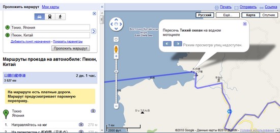
And if you decide to go, say, from Boston to Sydney, Google Maps will help you with route planning, and 2756 miles of travel through Pacific Ocean they will advise you to overcome it in a kayak - a single kayak. In other words, if you plan to travel as a couple, then following the advice of Google, it is worth taking two boats. 
It is interesting that earlier, when laying a route from North America to Europe, Google Maps offered to swim across the ocean. In the current version of the service, the calculation of routes between points so far from each other does not work. 
1.68 kilometers of love
Google Maps have many different functions, one of which is laying your own routes. Photographer Derek Montgomery, 28, used it to upload his daily runs. And then one day, looking at the path done on Google Maps, Derek found that it somehow resembles a letter. And since at that moment he was thinking about how to propose to his beloved, interesting idea: run a path that, when loaded onto the map, will look like the letters MARRY ME? (Will you marry me?).
It took Derek several attempts to implement his plan. Firstly, it was necessary to find a suitable place without trees, where nothing would interfere with writing out the necessary zigzags. By the way, Google Maps helped with this - Derek looked at the pictures of the area near his house and found two football fields located next to each other.

Secondly, Derek was forced to draw a run plan, because in order for his route to turn into readable letters, it was necessary to run along a strictly defined trajectory. But even with the plan it didn’t work out right away - in the data downloaded from the GPS watch to Google maps, the letters were not readable. When, after another workout, the loaded route finally satisfied young man he didn't waste any time. That same evening, Derek asked the girl to look at the plan for his run today, informing her that something strange had happened to the GPS data. 1.68 kilometers of love and 1250 calories burned while jogging did their job - the girl answered “Yes”.
Symbols of love
The love theme on Google Earth is almost inexhaustible. As it turned out, there are dozens of objects on Earth that, when viewed from above, have the shape of a heart. Some of them are the fruit of human activity, but those created by nature are much more interesting.
For example, in 2009 Galesnjak island in Croatia became widely known. Its owner, Vlado Giuresco, was quite surprised when, on the eve of Valentine's Day, he was approached by many couples with a request to stay on the island. The island is uninhabited, and few people showed interest in it until Google Earth revealed that it has the shape of a heart. And since Croatia is tourist country, the presence of the island of lovers turned out to be very handy. You can admire the island by typing "Google Earth" in the search bar coordinates 43°58’42.70″N, 15°23’0.14″E.
You can also take your loved one to german city Braunschweig, where there is a small pond on the territory of the Bürgerpark, which, like the island of Galesniak, has the shape of a heart. You can quickly move to this place by entering the coordinates 52°15’27.48″N, 10°31’17.62″E. 
And the biggest kiss in the world can be sent from Sudan. That is where it is interesting find, which was dubbed the lips of the Earth. A nondescript hill about 800 meters long, when viewed from above, really resembles huge lips. The find coordinates are 12°22’13.32″N, 23°19’20.18″E. 
Canadian Badlands Guardian
One of the most remarkable discoveries in google maps made fifty-three resident of Canada Lynn Hickox (Lynn Hickox). Using Google Earth, she tried to find her way to a dinosaur museum near her home, but instead she saw a huge Indian head, which was later dubbed the Badlands Guardian. The relief, approximately 255 by 225 meters in size, is located in the province of Alberta, near the border with the United States. The "face" itself natural origin, but people worked on the creation of "headphones" - in fact, this is an oil well and the road to it.

This place, unlike the Croatian island, has no tourism potential - there is not much to see from the Earth, and the territory is closed. However, thanks to Google's aerial imagery, the Badlands Guardian and the place where he is located, has gained truly worldwide fame.
Interestingly, the farmers who rented the land on which the Indian was found found out about the hype that had risen on the Internet about this site, quite by accident. When the land lease for the next ten years came up, they drove to the nearest town, where they were told about the Badlands Guardian.
To see the Indian with headphones, enter the coordinates 50.010083, -110.113006.
Drawings in the fields
An Arizona farmer spared four hectares of land to create a giant portrait of the famous TV presenter Ofra Winfrey. You can see it if you enter in the search bar "Google Earth" coordinates 33.225488, -111.5955.
Interestingly, next to it, in the neighboring field, there is another lesser-known drawing. The giant inscription on the field is very reminiscent of News 3D - I wonder if the farmer reads our site in the morning?

Lenin is always alive
In May 2008, Google Earth enthusiasts combing maps of Russia discovered a gigantic inscription "Lenin is 100 years old" between the Siberian villages of Trud, Znanie and Zverinogolovsk. The inscription was formed with the help of trees cut down (and possibly planted) in a special way. Due to the nature of the inscription, it is easy to determine the time of its creation - 1970. Could the Siberians, performing such a grand task, think that after forty years the results of their work could be seen by anyone simply by entering the coordinates 54.468142.64.79923 into Google Earth? 
The amazing find was just the beginning. It turned out that there are quite a lot of similar symbols of the past on the territory of Russia. For example, the same inscription, carved from trees, was found near the village of Arkhangelskoye (coordinates +54.419444, +56.780278), and on the banks of the Tura River there are huge letters “Glory to the CPSU” (coordinates 58.346111+59.803611). 
Observant Google Earth users also found several inscriptions created for the fiftieth (coordinates +57.091111+40.854444) and sixtieth (coordinates 54.623889+65.019444) anniversaries of the USSR (1967 and 1977, respectively).

But the time of the creation of the giant word "Lenin" is close Belarusian village Lyaskovichi (coordinates +52.158333+25.562222), unfortunately, is unknown - there are no dates in the inscription that could tell when this happened. 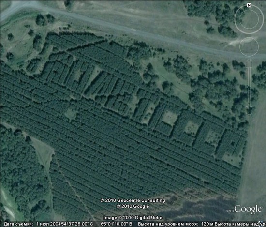

Get on Google Maps
search interesting objects Entire communities of people all over the world are engaged on Google Maps. Some (like the Canadian who discovered the Indian in the headphones) are lucky almost the first time, others spend days on satellite maps, but find nothing particularly surprising.
However, if nothing remarkable can be found, you can go the other way - create an object with your own hands that can get on Google maps and become available for viewing by the whole world. So, for example, in September 2008, the residents of Chelyabinsk amounted to main square city giant smiley with a radius of about eighty meters. True, despite the fact that the Google satellite shot a bright symbol, which amounted to several thousand people, it still has not appeared on the maps. 
More fortunate enthusiasts from National University Oregon, who celebrated the release of the second version of Firefox by creating a huge program logo on the field. The logo, about 67 meters wide, can now be seen on Google maps. To do this, just enter the coordinates 45.123464, -123.11431. 
English alphabet on Google Maps
The potential of Google Maps is inexhaustible. For example, they can be a source of inspiration for people in creative professions. Australian designer Rhett Dashwood assembled the first English alphabet from aerial photographs. It took the designer about six months to find all the letters on Google Earth. Interestingly, the search area was limited to the Australian state of Victoria. Links to all the places that are in the alphabet can be found on Rhett's website. 
Twenty-five-year-old Briton Rachel Young (Rachel Young) got into a car accident and was forced to comply with bed rest. After reading about an Australian designer's alphabet, she decided to make her own using UK maps. Searching suitable places on the maps, it took her much less time than the Australian - only 15 hours. It is interesting that, according to the British, during this time she discovered about a hundred variants of the letter B, but the letters K, N and Q did not want to be. 
But the story with the alphabet did not end there either. After Rachel showed her alphabet to the news agency she works for, she was asked to look for letters on a map of New York City. Despite the fact that the British woman had never been to this city, in just five days she completed the task and compiled another English alphabet, this time from aerial photographs of New York.

Dutch designer Thomas de Bruin went even further. Exploring the map of the Netherlands, he found on it all the capital and lowercase letters of the alphabet. In addition, he supplemented his alphabet with numbers from one to ten and punctuation marks. 
You can see the results of Thomas' work on his Flickr page.
Zone 51
In the Google Earth search bar, you can enter not only coordinates geographical objects or their names. If you try to find a secret military facility, codenamed "Area 51" (Area 51), the program will "give out military secrets" and show the legendary American base in Nevada. 
Many sincerely believe that it is in this place that the secrets that the American government carefully hides from civilians are located - either UFOs will be noticed there, or rumors will spread that the landing of astronauts on the moon was actually filmed at this base.
Looking at photographs of our planet taken from space, you can find a lot of intriguing and sometimes inexplicable things, especially if you connect your imagination while viewing.
Bright Side collected mysterious objects and places that users have discovered on Google maps.
Wasteland Guardian

In November 2006, Lynn Hickox discovered on Google Maps a geological formation located in the Canadian province of Alberta, resembling an Indian head with an earpiece in his ear. Such an image appeared as a result of prolonged soil erosion, and the wire from the earphone and the ear - the road leading to the oil rig, and the rig itself.
Blood lake in Iraq

In 2007, near the Iraqi city of Sadr, a blood red lake. Versions of the origin of the anomaly were very different - from sewage to waste from a nearby slaughterhouse. But the reason for this color of water has not been established. Today the lake looks just like the others.
Heart shaped island

Galeshnyak Island , belonging to Croatia, was discovered on satellite maps in 2009. The island quickly became popular, not only on the Internet, but also among travelers - before that, an uninhabited part of the land turned into a place of pilgrimage for lovers from all over the world.
Fingerprint labyrinth

A labyrinth in the shape of a human fingerprint, made of limestone tiles, is located in Hove Park in Brighton, UK. It was created in 2006 from a sketch by artist Chris Drury.
"Murder scene" on the lake in Almere, the Netherlands

A satellite image taken in 2009 in the Netherlands was discovered by one of the users of the Reddit website. The scene seemed like a murder, and there was a heated discussion on the site about what it really was.
However, no bloody crime was recorded in this picture. Almere resident Jacqueline Kenen identified the brutal "killer" as her golden retriever, who she says loves to swim. And what was taken for traces of blood is actually just water that has been glassed from the dog's fur.
Building in the shape of a swastika

The swastika-shaped building belongs to the US Navy and was spotted by Google users in 2006. The command of the Navy said that the similarity with this figure was discovered only at the construction stage, when nothing could be changed.
In 2007 $600,000 was allocated to change the landscape and install solar panels so that they hide the shape of the building. As of 2017, thanks to solar panels, the building no longer resembles a Nazi symbol.
People in dove masks

This street shot was taken in the Japanese town of Musashino in March 2013. This "composition" was built on purpose - the users and the site team Daily Portal Z having learned that the streets will be photographed for Google decided to immortalize itself on the map.
A ship overgrown with trees

This derelict and tree-covered ship was captured by satellite on the Parramatta River near Sydney, Australia. The ship named SS Ayrfield was launched in 1911. In 1972, she was decommissioned, and since then the ship has been moored at the mouth of the river.
UFO in Romania

An object that looks like a UFO from science fiction films was found on one of the abandoned farms next to Romanian city Timisoara. The discovery gave rise to a lot of rumors about the visit of an alien ship to Earth. In fact, a flying saucer is abandoned water tower, which used to supply Timisoara with water.
Desert breath

Strange circles in the Sahara Desert were created in 1997 by the hands of people who are members of the creative association D.A.S.T. The sculpture was made of two spirals emanating from the center, one of which was created from cones expanding as they moved away from the beginning, and the second from recesses built according to the same principle.
According to the creators, the spiral should disappear over time under the influence of erosion. However, even now, 20 years later, it is perfectly visible even from space.
Military Aircraft Cemetery

Davis-Monten Air Baseis located near the city of Tucson in the United States and is perhaps the world's largest place for the conservation of aircraft - about 4,400 aircraft and 40 spacecraft are laid up here. Every year, about 400 pieces of equipment come here and the same number is sold or destroyed.
Strange Creature from Loch Ness

25 year old Jason Cook, looking at satellite imagery Loch Ness, noticed a creature swimming in its waters. And although there is no reliable evidence of the existence of the famous monster, many believed that it was the Google satellite that captured it.


