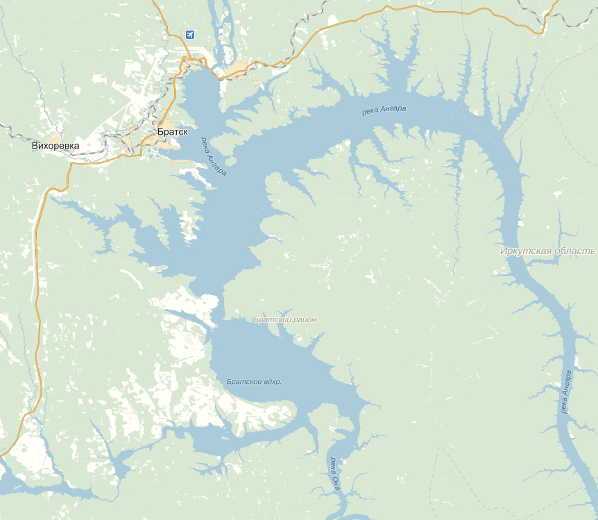
Bratsk reservoir. Map of the fraternal reservoir
The Bratsk Reservoir occupies a part southern territories West Siberian Upland. The Angara filled its basin with its waters for six years before the start of the hydroelectric power plant. Today it is the world's largest artificial body of water on the river. Along with three more operating and two at the design stage, it is part of the Angarsk HPP cascade.
Bratsk reservoir: history of construction, characteristics
The Angara River, on which a grandiose dam was built in 1961, originates in Baikal and flows into the Yenisei River. The reservoir is located on the site of the first third of the river artery, not far from the confluence of the Oka River into the Angara. Before its location and further downstream, the river was blocked in three more places in order to give the energy of its waters for the life support of cities and industrial facilities.

The construction of the Bratsk hydroelectric power station, begun in 1961 and completed in 1967, was recognized at one time as the construction site of the century. The first builders in the harsh climate of the plateau endured conditions bordering on the threshold of survival: they lived in tents and barracks in severe frosts. The enthusiasm of the builders brought an unprecedented result - a giant hydroelectric dam and its functional units were built in six years. The construction also broke another record - it became the most efficient hydroelectric power plant in the world: its payback for 25 years exceeded the construction costs by five times.
The water level of the Bratsk reservoir
In dry years, the reservoir recedes from the maximum mark of the coastline by ten meters. The rivers and streams flowing into its basin, the largest of which are the Oka, Iya and, of course, the Angara itself, form numerous bays, creating a heavily indented coastline. During half a century of the existence of an artificial reservoir, the shores are gradually slipping, forming many kilometers of shallow water. Along the gently sloping shores of the reservoir, wide sandy spits arose.

(Sandy shore of the Bratsk reservoir)
Reservoir dimensions: area, volume, depth
The reservoir at maximum filling occupies an area of 5470 square meters. km, when dry it decreases to 3133 sq. km. m. It is marked on the map by a strongly curved blue stripe, the length of which is 500 km. The width of the reservoir in some places is slightly more than one km. At the confluence of the Oka with the Angara, the reservoir forms two lakes connected by a narrow strait, maximum width which in the central part reaches 25 km - there they look like real seas. In some places, the depth of the reservoir is 150 m, but there are areas in bays where the bottom protrudes above the surface of the water surface.

Water temperature and currents
The water of the Bratsk reservoir comes from Lake Baikal, so at the entrance to the basin of the reservoir it is clean, bright and cold. In winter, the reservoir freezes completely, forming an ice cover up to 1.25 m thick in especially cold seasons. Ice cover takes different years five to seven and a half months. During the rest of the year, the reservoir is used for busy navigation. The water temperature in the summer months on the surface and up to one meter deep does not heat up above 15-20 ° C.
The water flow rate for the reservoir is quite high: on the surface it is approximately 1 m/s. At a depth in some places, the water practically stands still, moving towards the dam at a speed of one millimeter per second.
The composition of the water in the reservoir

If in the upper part of the reservoir, where the Angara flows into it with its clean Baikal water, the ecosystem pleases with health, the water has a high second class in terms of purity, then in the area of \u200b\u200bthe source from the reservoir, at the dam, it shows the limiting indicators for pollution. The composition of the water has a low degree of mineral dissolution - this is a typical picture for the hydrocarbonate type water resources Earth.
Angara, before the construction of a dam on it, was very rich in commercial fish species. Living conditions for sturgeon and salmon were ideal for temperature regime, the abundance of food, the speed of the current. Today, a typical lacustrine composition of inhabitants has been established in the reservoir. These are mainly non-commercial fish species: perch, pike, bream, ruff.
Dam of the Bratsk Reservoir

The reservoir dam is 924 meters long and 124.5 meters high and is built of concrete. It consists of three sections: deaf, stationary and spillway. On the coast, it is continued by concrete dams about half a kilometer long and earthen embankments with a total length of more than three and a half kilometers on both banks.
The dam not only serves as an obstacle to the free movement of the river. On its top, the railroads of the BAM and the highway are laid. They connect the banks of the Angara for busy traffic from the European part of the country to the Asian one.
Cities on the Bratsk Reservoir

During the construction of the dam of the Bratsk hydroelectric power station, large and populated areas had to be liberated from the indigenous people who lived here. For them, new cities were built and the plateaus that were previously in this part of the plateau were enlarged. settlements. So, Bratsk appeared on the site of the ancient village - the most Big City on the banks of this reservoir. The cities of Balagansk, Cheremkhovo, Svirsk now stand in the area of the reservoir. The reservoir provides their residents and industrial facilities built here with drinking and technical water - four large water intakes have been built on it.
The reservoir is an important transport artery of the region. It has 40 passenger berths, a timber loading and storage terminal and two cargo ports. As soon as the ice frees the surface of the Bratsk reservoir, a busy movement of ships and means for transporting timber begins. Many industrial enterprises operate within the basin of the Bratsk reservoir. The electricity generated by the Bratsk HPP provides almost all the capacity of the country's largest aluminum smelter.
Image from the Resurs.F1 spacecraft, KFA 1000 camera, scale about 1:180,000.
The Bratsk reservoir is located in the southeast of the Central Siberian Plateau on the territory Irkutsk region. This is one of the largest artificial reservoirs on the globe. The reservoir was formed after construction in 1961–1967. dams of one of the world's most powerful (4.5 million kW) hydroelectric power plants. In some places, its depth exceeds 160 m, and the total length is about 570 km. The configuration of the reservoir is very complex (long winding bays and a wide reach). The reservoir carries out long-term flow regulation; level fluctuations reach 10 m; used for shipping, rafting, water supply and. At the northern frame of the picture is visible South part Ust-Ilimsk reservoir, formed as a result of the construction of the dam of the hydroelectric power station of the same name on the Angara and created normal conditions for navigation.
The Angara Ridge is visible in the western part of the image, located in the southeast of the Central Siberian Plateau. Where the Angara cut through it, the famous Angara rapids formed, flooded by the reservoir. The relief of the ridge is diverse - table mountains, cone-shaped hills, steep ridges, loaf-shaped hills, rocky remnants. Within the space image, the most high points Angara Ridge - 837 and 980 m. The rivers, cutting through traps, flow in narrow, often canyon-like, valleys. Their channels are rapids. The vegetation cover is represented by mountainous southern taiga dark coniferous and larch-pine forests.
The city of Bratsk was founded in 1955 in connection with the construction of a hydroelectric power station to the north of the ancient settlement of the same name, founded by the Cossacks in 1631 as a prison and flooded by the waters of the Bratsk reservoir. Bratsk consists of several separate parts ( central part, settlements Energetik, Bikey, Osinovka, Chekanovsky, Porozhsky), remote from one another for tens of kilometers. Not far from the central part of the city are large and aluminum plant. In the north of the city, near the hydroelectric complex, there are settlements of power engineers, hydroconstructors, and transport workers. Bratsk - River port at the Bratsk reservoir, railroad station. The airport provides direct communication with Moscow, Irkutsk and other cities. On space image iron and car roads- the initial section of the Baikal-Amur Mainline Taishet-Lena, which facilitated the construction of the Bratsk hydroelectric power station. The picture shows numerous power lines. To the east of Bratsk is located resort area- Brotherly seaside.
 Download
«
»
Download
«
»
Download"Bratskoye Reservoir" free of charge, and you can also download many other maps in our map archive
Located in the southwestern part of the Irkutsk region of the RSFSR, it is one of the largest artificial reservoirs in the country. The Bratsk reservoir was formed as a result of the backwater of the Angara waters by the dam of the Bratsk hydroelectric power station, which is the second stage of the Angara cascade of hydroelectric power stations. The dam was built 605 km below Irkutsk.
The filling of the reservoir began in September 1961 and ended in September 1967. The area of the water surface of the reservoir (at the FSL) is 5470 km 2, the total volume is 169.3 km 3, the volume of the drain prism is 48.2 km 3.
The backwater from the Bratsk HPP extends along the Angara for 535 km along its tributary of the Oka - for 330 km and along the Iya River, which is a tributary of the Oka - for 150 km.
For a greater extent, the Bratsk reservoir has a channel character, due to the flooding of the valleys of the Angara, Oka and Iya rivers; the width of individual lake-like extensions located in the northwestern part reaches 20 km. Depths along the channel of the Angarsk direction increase from 12-14 m in the upper part to 100-110 m in the lower reaches of the dam.
In plan, the reservoir stretches in the general meridional direction; its small section from the village of Zayarsk to the city of Bratsk has a latitudinal direction. Due to the fact that the bed of the Bratsk reservoir is the Angara, Oka and Iya rivers, three main directions have been established along the reservoir: Angarskoye, Okskoye and Iya.
The total length of the coastline of the reservoir is 6000 km. The shores of the reservoir are heavily indented by rivers of various sizes and deeply protruding bays.
The northern and eastern shores of the Angarsk direction are high with steep, sometimes steep slopes. Comparatively flat eastern shores Oksky direction and southern shores latitudinal part of the Angarsk direction.
Under the influence of waves and mainly due to the rise in the level of groundwater caused by the filling of the reservoir, intensive erosion of the banks occurs. As a result, the coastal slopes become more gentle. Shoals are formed in the coastal part, which in some places create difficulties for ships to approach stopping points. Coastal rocks that collapsed under the influence of erosion are partially transported by currents over considerable distances along the coast, which leads to the formation of spits at the entrance to bays and bays.
coast north of the village Ust-Uda (270 km) is mostly covered with taiga, which south of the village passes into the forest-steppe.
hydrometeorological information. The climate in the area of the Bratsk Reservoir is continental, characterized by large amplitudes of temperature fluctuations both during the year and during the day.
The highest air temperature is observed in July and reaches 35°. Most cold month- January, when the temperature drops to minus 40-52°.
Thaws in winter are extremely rare, and in most cases they are not observed at all in winter. Average annual temperature air according to meteorological stations located both in the northern and in the middle part of the reservoir, minus 1-3 °.
Wind and excitement. During the navigation period, the reservoir is observed mainly light winds breeze nature, not affecting the conditions of navigation.
Of the winds that impede navigation, westerly winds have the highest speed, frequency, and duration. Winds reach their maximum speed on lacustrine extensions.
The direction of the wind blowing in the area of elongated and narrow sections of the reservoir is significantly affected by the relief of the surrounding area.
Most strong winds come in spring in May and in autumn in October - November. In the autumn months, winds at a speed of 8-10 m/s blow for 15-18 days, at a speed of 10 m/s and more - 10-12 days. Max speed winds can reach 20-24 m/s with gusts up to 28 m/s. Storm winds of western directions have the highest frequency.
IN summer time(July - September) at the reservoir there are squally winds, which have a relatively high speed - 15-17 m / s with gusts up to 20 m / s, but are characterized by short duration and instability.
The greatest wind waves develop in lake-like areas (Balaganskoe extension, south- East End Zayarsky expansion, Dolonovsky and Kaltuksky expansions, as well as the confluence of the Oka and Iya directions). highest height a wave of 2.3 m was observed near the village of Zayarsk with a westerly wind at a speed of 16 m/s. However, at high wind speeds, the wave height in some open areas of the reservoir can exceed 3 m. The wave length can reach 20-25 m, and the period is 6-7 seconds.
The frequency of significant and strong waves (wave height of 0.75 m or more) during the navigation period in the above areas reaches 26%, with 1.8% being waves of 2 m or more. The duration of storms with a wave height of 0.75 m or more sometimes exceeds 40 hours.
The East Siberian Basin Administration of the Way, together with the Bratsk Meteorological Observatory, has published the Wave Atlas of the Bratsk Reservoir, which provides information on the height of the waves at winds of various strengths and directions. Using this Atlas, the navigator can choose a section of the reservoir that is calmer from waves for the movement of the vessel.
According to the conditions of the wind-wave regime, the Bratsk reservoir is divided by the river register of the RSFSR into sections that are assigned to one or another category.
The category "O" includes:
In the Angarsk direction - the section from the dam to the village of Barkhatova (130 km from the Irkutsk bridge);
In the Oksky direction - a section from Mount Kovrizhka up to 188 km;
In the Iya direction - a section from the mouth of the Iya river up to 45 km.
In the sections of the reservoir from the dam to the village of Zayarsk, from the village of Ust-Uda (270 km) to 185 km along the Angarsk direction, from Mount Kovrizhka to the Tynkob Bay along the Oksky direction, class “O” ships are allowed to navigate with a wind force of no more than 6 points and with wave height not more than 2 m.
The "R" category includes:
Angarsk direction above the village of Barkhatov;
Okskoe direction above 188 km;
Iyskoye direction above 45 km.
The "L" category includes:
The Oka River is above 330 km;
The Iya River is above 180 km.
Fog and precipitation. Fogs are observed at the reservoir in the morning during all periods of navigation. The greatest number of days with fogs occurs in August - September. For navigation, their number ranges from 25 to 40. Severe frosts are accompanied by fogs.
The greatest amount of precipitation falls in the warm season from May to October (75-80% of the annual norm).
Snow falls in late September - early October. The snow cover lasts 6.5-7 months and melts in April-May. The average thickness of the snow cover is 25-30 cm.
The level regime of the reservoir depends both on the water content of the year and on the operating regime of the Bratsk and Irkutsk HPPs.
Every year, the filling of the reservoir begins from the end of May and ends by October, when the highest annual level is reached, close to the FSL. At the end of navigation there is a drop (drawdown) of the water level, and in April - May the level of the reservoir is the lowest.
The normal retaining level is 401.65 m. the maximum allowable drawdown of the reservoir was set at 10 m from the FSL. The maximum navigation drawdown by these rules is set at 7.0 m to the level of 394.65 m. During the flood period, the highest level of the reservoir is allowed 1 m above the FSL. At the Bratsk reservoir, under the influence of winds, surge fluctuations in the level are observed; level fluctuations during surge and surge can reach 0.5 m or more.
currents. Both runoff and drift currents are observed in the reservoir. The former are the natural movement of water from the upper part of the reservoir to the dam, the latter are caused by the action of the wind. The speed of the runoff flow to the reservoir during calm is 0.1-0.2 km/h, in some narrow places 0.2-0.4 km/h.
Drift currents are of great importance. With prolonged exposure to wind, their speed reaches 0.9-1.3 km / h or more. In the area of the village of Zayarsk, with a long storm wind of the western quarter, a current speed of 1.7 km/h was recorded. In some cases, under the influence of wind, currents arise that are directed in the direction opposite to the natural flow of water, i.e., upwards from the dam.
Ice regime. Due to the large extent and temperature fluctuations in the autumn period, the freezing of the Bratsk reservoir begins from bays and relatively shallow areas in the upper part of the reservoir. The formation of the ice cover is slow - from the first half of November to mid-December, and in some years continues until the third decade of December.
The reservoir is covered with ice for an average of 6 months, the thickness of which reaches 1.5–2.0 m. for vehicles on ice.
The opening of the Bratsk reservoir from ice begins in the first half of April from the upper part of the Angarsk direction. Somewhat later, the dam part and narrownesses are opened in the Oka and Iya directions. The longest ice stands below the village of Zayarsk, forming a bridge up to 20 km long. The final clearing of the reservoir from ice occurs in late May - early June.
The duration of navigation in different areas is different. Thus, the average duration of navigation in the Angarsk direction is 162 days, in the Oksky direction - 151 days and in the Iisky direction - 147 days.
Path dimensions. As of navigation in 1973, the following track dimensions are guaranteed on the Bratsk reservoir: depth 2.5 m, width 80 m, radius of curvature 500 m.
These values are determined by the dimensions of the approaches to the berths and forest roadsteads.
Shipping situation. The onshore and floating shipping environment at the Bratsk Reservoir ensures round-the-clock navigation of ships and complies with state standards.
The coastal situation is represented only by the signs "Landmark" and a beacon with a powerful flashing light installed on Mount Bratskaya.
The numbering of buoys in the Angarsk direction, in the Osa and Unga bays is carried out downstream, in the Oka and Iya directions - against the current.
The zones of location of underwater crossings are fenced with appropriate signs.
Ports and marinas. The ports of Svirsk and Bratsk are equipped on the Bratsk Reservoir, which have mooring and handling facilities. The description of the ports is given on the corresponding sheets of the map.
Berths and stopping points on the reservoir are partially equipped with floating mooring devices. In most places, ships moor to an undeveloped shore.
The Bratsk reservoir ranks second on the planet in terms of the volume of accumulated water. Thanks to its creation, the possibilities of navigation, timber rafting, and water supply to nearby regions have increased.
Location: in the Irkutsk region of the Russian Federation
Length: 570 km
Width: 25 km
Average depth: 31 m
Maximum depth: 100 m
Sources of water supply: the Angara, Oka, Iya rivers and several small tributaries
Altitude above sea level: 396 m
Area: 5450 sq. km
Settlements on the coast: Bratsk, Svirsk, Usolie-Sibirskoye, Vikhorevka
Origin of the reservoir: formed in 1967 by a dam for the construction of the Bratsk hydroelectric power station
Bratsk reservoir on the map of the Irkutsk region.
A little more detailed map Bratsk reservoir.
Fishing on the Bratsk reservoir

Fish species: bream, carp, crucian carp, rudd, eel, perch, grayling, pike, carp, roach, omul, whitefish, carp, sterlet
Siberia in general, and the Bratsk Reservoir in particular, are very rich in a variety of fish. To enjoy fishing, some fishermen agree to travel several hundred kilometers to these places. Summer fishing is possible from the shore (only in dry weather) and from a boat. In the warm season, it is easier to park the car directly near the place of fishing. Whereas in winter the car may not reach the right place, and you have to walk a decent distance with things and equipment. But the result of fishing usually erases all difficulties from memory. After all, there is enough fish in the Bratsk reservoir for everyone, and sometimes there are individuals over a kilogram. To increase the population of rare species, thousands of fry are released into the reservoir every year.
Perch is the most common, especially on winter fishing. It is caught mainly by sheer flashing.
Favorite places of fishermen on the Bratsk reservoir: the villages of Tynkob, Omka, Artumey, Mindey, Sedanovo, Tarma, Shumilovo, Ermakovka, Tarevo; Padunsky Bay, Pristansky Bay.
Video: Catching perch on the Bratsk reservoir in the village of Shumilovo.
Rest on the Bratsk reservoir

Green forests and yellow sands framing the blue expanse of water brotherly sea, and attract tourists! Despite the very long coastline (about 7000 km), there is not much tourist bases and hotels. There are also sanatoriums, and children's camps, and campsites, but there are more “wild” places.
You can also find housing with enterprising people local residents. Prices vary not only depending on the living conditions, but also on the mood of the owners. Therefore, bargaining is always possible and necessary.
It is very popular to relax on the Bratsk reservoir with tents. Here you can meet residents of the Irkutsk region and other regions of Russia. It's nice to swim, sunbathe and sit with a fishing rod when there are such picturesque places around.
The best beach of the Bratsk Sea is Golden Sands. The beach is guarded, there are toilets, shops. There is an entry fee for cars. You can put up tents and make fires. The sand is fine, the water is clean and clear. There are even small waves, everything is like on a real sea. Golden Sands is located near the village of Osa in the Osinsky district. The distance from Irkutsk is about 200 km.


