Brotherly Sea. What went under the water? Map of the Bratsk reservoir. Photo from space
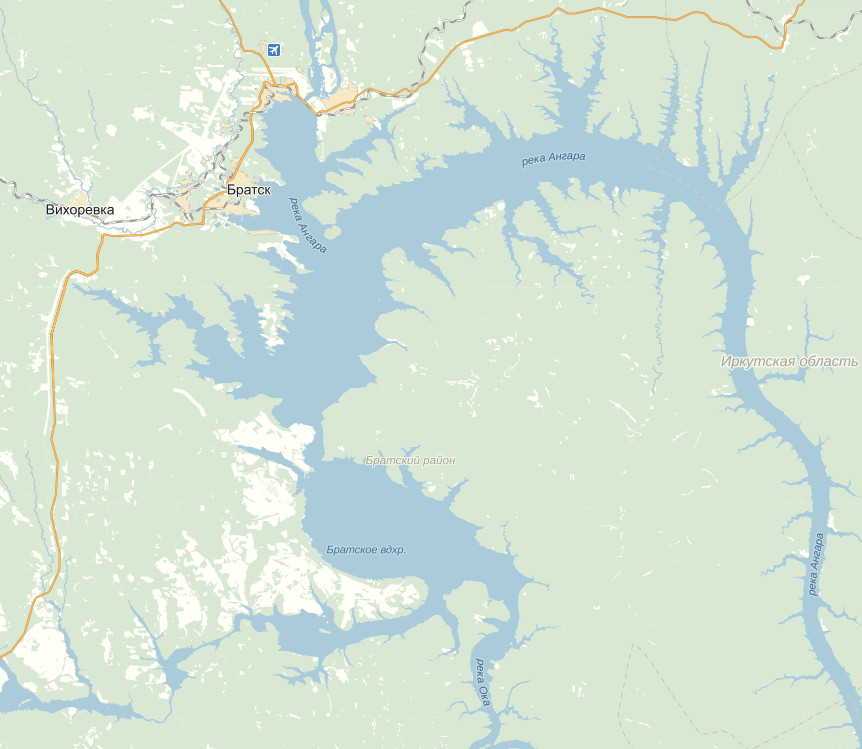
113 km from Irkutsk, after the Bolshoi Island and the Narym channel, approximately opposite the mouth of the Belaya - the third major inflow Angara - the backwater of the Bratsk reservoir begins to be clearly felt. It was formed during the creation of the Bratsk hydroelectric power station and is the second stage of the Angarsk cascade. Filling up to the design mark took place from 1961 to 1967. Carrying out deep long-term regulation of the Angara runoff, Bratsk reservoir in terms of its volume - about 170 cubic km - the largest artificial reservoir in Russia and the world (from among the run-of-river reservoirs); only one African reservoir Victoria (Owen Falls), created on the basis of huge lake, exceeds Bratskoye in volume. The area of the water surface of the Bratsk reservoir is 5470 sq. km, the useful volume is more than 48 cubic km, the length (along the Angara valley) is more than 500 km, the maximum depth at the dam is 106 m.
When traveling by boat, the length of the waterway will inevitably more length reservoirs due to approaches to marinas and moorings, entry into bays, etc. All the way from river station Therefore, Irkutsk to Bratsk increases from 606 km along the direct transit route to 660 km actual.
Almost along its entire length, the Bratsk reservoir has a general orientation to the north along the former Angara, and, in the zone of wedging out of the backwater (approximately to Svirsk), the reservoir is still little distinguishable from the river. Its width varies here from 1 to 4 km, the average depth is 8 m, the water temperature does not exceed 12-14 degrees. Down from the mouth of the Belaya, steppe and forest-steppe, developed by agriculture, stretch along the banks. The banks are steep, ancient limestone rocks are visible on them in the form of horizontal and inclined layers, painted in light and gray tones.
On the right bank, opposite the mouth of the Belaya, there is the picturesque village of Olonki, where the first Decembrist V. Raevsky lived in the settlement for many years. Further, along the same shore, you can see the village of Buret, famous for the rich Upper Paleolithic site discovered here. On the left bank is the Barkhatovskaya timber transshipment base.
After 139 km of the waterway from Irkutsk, the ship arrives at the port of the small satellite town of Cheremkhovo - Svirsk (19.5 thousand people), connected with it by rail and highway. Svirsk was given life by the Vostsibele-ment plant for the production of accumulators, galvanic cells and batteries, which went into operation in 1940, and the status of a city was assigned in 1949. Works here ferry crossing.
Beyond Svirsk railway line departs from the reservoir to the west. Cities and towns are left behind, the landscape becomes exclusively rural.
12 km from Svirsk on the right bank at the mouth of the Ida is the ancient village of Kamenka, founded in 1669 as a prison. Now the place where the prison stood is flooded with a reservoir.
Below the mouth of the Ida, the lands of the Ust-Orda Buryat National District occupy not only the right, but also the left bank of the reservoir, which crosses here the central area of historical settlement of the Baikal (Western) Buryats. Approximately, after 195 km from Irkutsk, the Bratsk reservoir expands to 7-12 km and acquires sea view. At 40-45 km, bays cut into the land: Osinsky on the right and Unginsky on the left. Average depths increase to 20 m, Maximum temperature- up to 19-20 degrees (even higher in bays).
Along the banks of the Bratsk reservoir, karst phenomena are observed - dips and subsidence, sinkholes and niches, landslides and subsidence of slopes, disappearing streams, etc. With the creation of a reservoir karst processes, characteristic of this region, increased sharply in coastal zone. The Bratsk Reservoir is also characterized by intensive processes of bank destruction associated with a large amplitude of water level fluctuations. Usually they do not exceed 2-3 m, but in dry years they increase to 5-6 m, and in critical periods - up to 10 m. total area erosion amounted to over 5 thousand hectares.
Below the Osinsky and Unginsky bays, the border of the Ust-Ordynsky district passes, the left bank is further occupied by the lands of the Balagansky district, the right bank - by Ust-Udinsky. The regional center - the village of Balagansk (4.2 thousand people) is located on the left bank, 262 km of the waterway from Irkutsk. Balagansky prison, founded in 1654, was repeatedly besieged by the Buryat and Mongol troops, and in 1775 was elevated to the rank
cities. After the filling of the Bratsk reservoir, Balagansk was put in a new place, 35 km from the old settlement, and practically nothing but the memory of the glorious past remained from the former city. Now it is known for its fish factory, which fishes fish in the reservoir and processes it; the old Shelashnikovsky tract passes through Balagansk, connecting Zalari on the Trans-Siberian Railway with Zhigalovo on the Lena; there is a ferry service. Near the village found interesting karst caves, and fossil marine arthropods, trilobites, have been found in limestones on steep shores.
Below Balagansk, for 150 km, the banks of the reservoir are steep and steep, painted in red and red-brown colors due to the predominance of clay rocks. 20 km from Balagansk, on the opposite bank, stands the village of Ust-Uda, the center of the district of the same name. Beyond Ust-Uda, the reservoir enters the taiga zone. The shores and coastal hilly areas are exceptionally picturesque, the water is warm, so the site is big interest for summer vacation.
After the large right-bank Uda Bay, the reservoir sharply narrows to 2-2.5 km and for 200 km to the north to Shumilovo repeats the smooth bends of the Angara. However, the depths here are large: the average is 40 m, the maximum - 75 m. The ship passes the villages of loggers with marinas - Klyuchi, Anosovo, Atalanka, Karda, Podvolnoye, Chisty, Karakhun, Priboyny, Yuzhny. All of them were built after the creation of the Bratsk reservoir, which flooded the old villages and villages (the native village of the writer V. Rasputin also remained under water). From here, to the north to Bratsk and, partially, to the south to Svirsk and Usol-Sibirsky, rafts with timber harvested in the territories adjacent to the reservoir go. From Podvolochny there is an old road (drag) to Ilim, from Karakhun new road to the Okinsky shore of the reservoir.
From Shumilovo (524 km from Irkutsk), the expansion of the Bratsk reservoir begins again. The shores here are very indented. Narrow bays look like fiords up to 40 km long. The ship approaches Zayarsk, located 562 km from Irkutsk and 98 km from Bratsk. This village is the successor of the flooded Zayarsk, created in the late 30s as a pier, a transshipment point and the beginning of a highway from the Angara to the Lena to the Ust-Kut region.
From Zayarsk, the ship turns west and heads towards Bratsk. The reservoir becomes especially wide - up to 12-15 km, and the maximum depths reach 95 m. From the right bank, a characteristic cape with Mount Monastyrskaya protrudes far into the sea, where the reservoir is divided into two large reaches: the main Angara and Okinsky-Iysky, approaching Bratsk from South. The maximum depths reach 106 and even 150 m, the width of the sections of the Oka part is 20-25 km, highest altitude waves during storms exceed 3.5 m. The length of the Oka branch of the reservoir is 320 km, and the Ii branch branching off from it is 180 km.
Bratsk port is located 660 km of the waterway from Irkutsk - final destination from the Meteor movement, from where the acquaintance with the legendary Bratsk begins - a living example of the enthusiasm and romance of the conquerors of Siberia in the 50s and 60s. Bratsk, founded in the form of a fort at the mouth of the Oka near the Padunsky rapids in 1631, was burned down more than once by warlike Buryat tribes, moved and rebuilt. The first political exile in Siberia, the leader of the schismatics and the talented writer Archpriest Avvakum, languished in prison. Not far from the middle of the XIX century. The Nikolaev iron-working plant worked, supplying products to England, Germany and China. However, for more than three hundred years Bratsk remained little-known village at the formidable Angara rapids.

Its fate changed dramatically in the mid-1950s, when the construction of the powerful Bratsk hydroelectric power station began. Bratsk today - Big city(259.3 thousand people, with adjacent settlements 287 thousand people), a powerful industrial bastion Eastern Siberia, widely known around the world as largest center electric power industry (Bratskaya HPP), pulp and paper industry (Bratsk timber industry complex - BLPK), non-ferrous metallurgy (Bratsk aluminum plant - BRAZ), mechanical engineering (heating equipment plant), construction industry (Bratskgesstroy). Bratsk is a major transport hub: Railway connects it with the Trans-Siberian Railway in the west, with BAM in the east and Ust-Ilimsk in the north, the waterway - with Irkutsk and Ust-Ilimsk, the highway - with Tulun, Ust-Ilimsk and Ust-Kut, the airport accepts TU-154 aircraft.
The ill-considered concentration of several gigantic enterprises in Bratsk led to a sharp deterioration in the state of environment and health of citizens. There are also complex transport problems, which arose due to the chaotic, broken planning structure of Bratsk, which represents a whole conglomerate of urban areas (Stroitel, Padun, Bratsk itself, Gidrostroitel, Energetik), adjacent villages (Chekanovsky, Porozhsky, Bikey, Osinovka) and industrial sites (BRAZ, BLPC and etc.), separated from each other by tens of kilometers.
Bratsk is also famous ski run with a cableway, the best toboggan run in the country, the sanatorium "Bratskoye Vzmorye". On the shore of the Bratsk reservoir there is a museum under open sky The Angarsk Village, where, among other exhibits, the tower of the Bratsk Ostrog, built in 1654, was transferred. The ethnographic composition of the Evenk camp presented in the museum, which reveals the life of the people who settled in the vast expanses of the Siberian taiga from the Ob to the Pacific Ocean, is very interesting.
Bratsk reservoir created on the river hangar in Irkutsk region during the construction of the Bratsk hydroelectric power station to generate electricity, develop shipping and fisheries.
Filling was carried out from 1961 to 1967. The Bratsk reservoir is the second on the river. Angara.
The catchment area in the site of the hydroelectric complex is 757,200 km 2, the average annual flow is 91,900 million m 3, during the flood - 61,000 million m 3.
With a FSL of 402 m, the area of the reservoir is 547 thousand hectares.
The total capacity is 169,300 million m 3, useful - 48,200 million m 3. Length 565 km, maximum width 33 km. Max Depth in the channel 106 m, the average - 32.6 m. The area with depths up to 10 m is 26.6%, with depths over 20 m - 55.2%. The area of shallow waters with depths up to 1 m is 12 thousand ha, from 1 to 2 m - 15 thousand ha.
The reservoir is divided into several sections.
Upper section (southeast, from the Kamenka point to the Uda Bay, 160 km long, including the upper part of the Angarsk reach to the dam Irkutsk HPP) is located in the steppe and forest-steppe zones with prevailing depths of up to 30 m and shallow bays of commercial importance. The rivers Irkut, Kuda, Belaya, Kitoy flow into it, in which salmon and dace breed and feed.
The middle section, 245 km long and up to 7 km wide (from Uda Bay to Ozerny Bay), is located in the taiga zone. There are many deep-water bays with flooded coniferous forest. Average depth along the old riverbed Hangars 40-50 m. The site includes the Zayarsko-Nartai reach ( Northern part), which has a strongly indented coastline And great depths. This site also includes the Ust-Udinsko-Balagensky reach, formed in the valley of the river. Angara and its tributaries Osa, Obusa, Unga, Kada, Odyssa, Birita, etc.
The lower section, 65 km long, 12-15 km wide, up to 90 m deep, from Ozerny Bay to the dam of the Bratskaya HPP, is located in the taiga zone. The coast here is steep and rocky.
The Oka river section, 62 km long, 100-200 m wide, as well as the Iysky shallow area with depths of 3-12 m, is located in the taiga zone with swampy soils. The shores are covered with forest. The Iisky Bay, 6-8 km long and wide, occupies the valley of the river. Ii. The Oka section also includes extensive stretches - the Kaltuk and Dolonovskoe extensions, 17-19 km wide, 38-78 m deep, located in the taiga zone. The right bank is steep, the left floodplain, floodplain, often with swampy soils.
Water exchange takes place once every two years. The level is triggered in winter period for 2.3-2.6 m, the limiting prism of drawdown is 10 m for energy purposes. In autumn, a relatively constant level is observed. The lowest level was recorded in May. During winter drawdown, 400-500 km 2 of the shallow water zone is drained and freezes through.
The reservoir, located mainly in the taiga and forest-steppe zones, is one of the most populated.
The ichthyofauna was formed naturally. 26 species of fish live in the reservoir: Siberian lamprey, sturgeon, sterlet, taimen, lenok, tugun, river whitefish, Siberian grayling, pike, perch, ruff, burbot, Siberian roach, silver carp, tench, dace and four acclimatized animals (carp, bream , Amur crucian carp, Baikal omul). The most common are roach, perch, dace, pike, ruff, and burbot. Taimen, lenok, grayling, sturgeon, sterlet are found in single specimens.
Fishing is carried out by fishermen from Baikalrybprom, Baikalrybakkolkhozsoyuz, Irkutsk fish processing plant. Commercial fish productivity in 1987 was about 2.0 kg/ha instead of 1.0 kg/ha in 1980.
Image from the Resurs.F1 spacecraft, KFA 1000 camera, scale about 1:180,000.
The Bratsk Reservoir is located in the southeast of the Central Siberian Plateau in the Irkutsk Region. This is one of the largest artificial reservoirs on the globe. The reservoir was formed after construction in 1961–1967. dams of one of the world's most powerful (4.5 million kW) hydroelectric power plants. In some places, its depth exceeds 160 m, and the total length is about 570 km. The configuration of the reservoir is very complex (long winding bays and a wide reach). The reservoir carries out long-term flow regulation; level fluctuations reach 10 m; used for shipping, rafting, water supply and. At the northern frame of the picture is visible South part Ust-Ilimsk reservoir, formed as a result of the construction of the dam of the hydroelectric power station of the same name on the Angara and created normal conditions for navigation.
The Angara Ridge is visible in the western part of the image, located in the southeast of the Central Siberian Plateau. Where the Angara cut through it, the famous Angara rapids formed, flooded by the reservoir. The relief of the ridge is diverse - table mountains, cone-shaped hills, steep ridges, loaf-shaped hills, rocky remnants. Within the space image, the most high points Angara Ridge - 837 and 980 m. The rivers, cutting through traps, flow in narrow, often canyon-like, valleys. Their channels are rapids. The vegetation cover is represented by mountainous southern taiga dark coniferous and larch-pine forests.
The city of Bratsk was founded in 1955 in connection with the construction of a hydroelectric power station to the north of the ancient settlement of the same name, founded by the Cossacks in 1631 as a prison and flooded by the waters of the Bratsk reservoir. Bratsk consists of several separate parts ( central part, settlements Energetik, Bikey, Osinovka, Chekanovsky, Porozhsky), remote from one another for tens of kilometers. Not far from the central part of the city are large and aluminum plant. In the north of the city, near the hydroelectric complex, there are settlements of power engineers, hydroconstructors, and transport workers. Bratsk - River port at the Bratsk reservoir, railroad station. The airport provides direct communication with Moscow, Irkutsk and other cities. On space image iron and car roads- the initial section of the Baikal-Amur Mainline Taishet-Lena, which facilitated the construction of the Bratsk hydroelectric power station. The picture shows numerous power lines. To the east of Bratsk is located resort area- Brotherly seaside.
On February 12, a group of 3 people went fishing to the Bratsk reservoir. Departure from Sayansk took place at 5 o'clock in the morning. We set off on a blue car Renault Logan - (Renault Logan). The car has a front-wheel drive and a 5-speed gearbox. First, our driver, Sergey, picked us up, and then we set off on the road through Kharaygun along the Anuchinsky tract.
The distance to the Spruce Bay, where our path lay, is not close, about 160 kilometers from average speed takes approximately 2.5-3 hours. We went there for 2 days, for the night we decided to stay in a winter hut.
Zimovye - a hut intended for temporary stay, the presence of people, more often in winter. It is built in the forest, usually on the shore of a reservoir. Our route passed through the Balaganskaya ice crossing with a length of 5.6 km, which is serviced by the Balagansky branch of JSC "DSIO". When driving on ice, on the side of the road lies a tractor that has fallen halfway under the ice, either this is an accident, or a monument that does not inspire optimism when approaching it ...
At the place we were almost at 8 o'clock in the morning, and went to look for a house for the night. There were few people on the ice in the morning, 5-10 people in each bay ... Fishermen were everywhere: off the coast, in the middle of the bay, and even in hard-to-reach places ice fishing enthusiasts could be seen.
We can say that we didn't have to look for a place for the night for a long time. Literally from the second time we stumbled upon a small hut, with a wonderful owner, whose name was Vladimir. He immediately offered us to stay with him and we gladly agreed. We unloaded a few things, had a bite to eat and went to explore the area.
On the first day, we stopped at a timber warehouse, which was located on the opposite bank of our winter hut. Leaving the car, we went in search of fish. For a long time we could not find a good place, and we were forced to move away from the road as far east as possible ...
Closer to 12 o'clock we managed to stumble upon a decent school of perch, which was located 10-15 meters from the shore. Personally, I pulled about 30-40 tails from this hole. Without hesitation, my partners joined me and, surrounding the fish, we managed to catch half a hundred fish each.
At about 6 pm, when dusk came, we began to slowly reel in the fishing rods. Approaching our car, we began to discuss the day's catch and, as it turned out, everyone had a good time. Each of us caught about 150 - 200 tails per day!
After discussing the catch, the weather, which was not very warm (the average daily temperature fluctuated around -20-25 degrees), we decided to try to drill near the road. I drilled the hole first, in order to get information about the depth in the place of fishing, and as soon as I lowered the mormyshka, a perch caught on both mormyshkas in the same second!
Everyone was shocked, because the depth in the place of fishing was less than one meter! We immediately set to work, and in this way we managed to add another 20 or even 40 tails to the catch.
Our winter hut was located at a low altitude and it was simply unrealistic to drive in a front-wheel drive car with all-weather tires the first time!
Seeing the car rolling back from the knurled hill, two strong men, 40-45 years old each, ran out to help us, who gladly helped us climb up and easily conquer the height.
Having entered the house, we were immediately invited to a table, at which everyone got to know each other. It turns out these two guys (Yuri and Andrey) were Zimintsy. Having drunk for a successful acquaintance, we easily found mutual language with countrymen. For dinner, there were dumplings, which Volodya prepared especially for us.
At 8 o'clock, after dinner, three men decide to go to the neighboring village (Klyuchi) for women .... (well, what else to do at night fishing) … =) I stayed in the winter hut with Victor (this is Sergey's friend, they studied and now work together at SayanskKhimPlast OJSC) and the owner of the house - Vladimir.
Returning with "Empty Hands" around 12 o'clock at night (I was already sleeping at that time), the guys said that they could not drive up the hill and called us to push the car. After long and diligent attempts to get out of bed, the guys realized that there could be no sense from the inhabitants of this hut, no matter how much they had to help us ...))) After all, they successfully noted the acquaintance ....
Having parked the car on their own, they entered the house and everyone went to bed ...
The morning for me started at 8 o'clock... Waking up, we had a good meal, packed our things and, after saying goodbye to Volodya, we all went to the ice. This time, on the advice of Andrei and Yuri Ziminsky taxi drivers, according to whom there was a good catch here yesterday, we went to their place.
On this day, I realized one thing, that having drilled a hole with an 80mm drill for two jigs, it is not advisable to catch it, otherwise you risk breaking the tackle by hooking it on the ice. Fortunately, we fished not far from the shore and it was not difficult to follow the branch, but it is not so easy to do this in half a meter of snow ...
Having successfully released the tackle from the hook, I went to the depth, where I caught about 40 perches. Caught on a small black mormyshka in the shape of an "ant" on a leash of "fluorocarbon" fishing line (BALSAX company) with a diameter of 0.14 mm. For comparison: below on the main (ordinary fishing line of the same diameter) I had a golden-copper "Ural" mormyshka, on which the bite was no worse.
On this day, we went fishing until lunch, the bite was weak, and we decided to go home. Departure took place at 14-30. And at 17-00 I was already at home.
The Bratsk reservoir ranks second on the planet in terms of the volume of accumulated water. Thanks to its creation, the possibilities of navigation, timber rafting, and water supply to nearby regions have increased.
Location: in the Irkutsk region of the Russian Federation
Length: 570 km
Width: 25 km
Average depth: 31 m
Maximum depth: 100 m
Sources of water supply: the Angara, Oka, Iya rivers and several small tributaries
Altitude above sea level: 396 m
Area: 5450 sq. km
Settlements on the coast: Bratsk, Svirsk, Usolie-Sibirskoye, Vikhorevka
Origin of the reservoir: formed in 1967 by a dam for the construction of the Bratsk hydroelectric power station
Bratsk reservoir on the map of the Irkutsk region.
A little more detailed map Bratsk reservoir.
Fishing on the Bratsk reservoir

Fish species: bream, carp, crucian carp, rudd, eel, perch, grayling, pike, carp, roach, omul, whitefish, carp, sterlet
Siberia in general, and the Bratsk Reservoir in particular, are very rich in a variety of fish. To enjoy fishing, some fishermen agree to travel several hundred kilometers to these places. Summer fishing is possible from the shore (only in dry weather) and from a boat. In the warm season, it is easier to park the car directly near the place of fishing. Whereas in winter the car may not reach the right place, and you have to walk a decent distance with things and equipment. But the result of fishing usually erases all difficulties from memory. After all, there is enough fish in the Bratsk reservoir for everyone, and sometimes there are individuals over a kilogram. To increase the population of rare species, thousands of fry are released into the reservoir every year.
Perch is the most common, especially on winter fishing. It is caught mainly by sheer flashing.
Favorite places of fishermen on the Bratsk reservoir: the villages of Tynkob, Omka, Artumey, Mindey, Sedanovo, Tarma, Shumilovo, Ermakovka, Tarevo; Padunsky Bay, Pristansky Bay.
Video: Catching perch on the Bratsk reservoir in the village of Shumilovo.
Rest on the Bratsk reservoir

Green forests and yellow sands framing the blue expanse of the waters of the Bratsk Sea attract tourists! Despite the very long coastline (about 7000 km), there is not much tourist bases and hotels. There are also sanatoriums, and children's camps, and campsites, but there are more “wild” places.
You can also find housing with enterprising people local residents. Prices vary not only depending on the living conditions, but also on the mood of the owners. Therefore, bargaining is always possible and necessary.
It is very popular to relax on the Bratsk reservoir with tents. Here you can meet residents of the Irkutsk region and other regions of Russia. It's nice to swim, sunbathe and sit with a fishing rod when there are such picturesque places around.
The best beach of the Bratsk Sea is Golden Sands. The beach is guarded, there are toilets, shops. There is an entry fee for cars. You can put up tents and make fires. The sand is fine, the water is clean and clear. There are even small waves, everything is like on a real sea. Golden Sands is located near the village of Osa in the Osinsky district. The distance from Irkutsk is about 200 km.


