The highest mountain in honor of the famous. The highest mountain in the world
What do you know about the highest peak in the world? What is it called Everest. Some will also remember alternative name- Chomolungma. Can you name the height? At least approximately. And where is it? Also no? Then once again we will talk about the highest mountains of the Earth.
The undisputed leader in terms of height, this mountain, like a magnet, attracts professional climbers, beginners and people just thirsty for extreme sports from all over the world. Climbing it is the cherished dream of everyone who has made at least one ascent to any other peak. And today, thousands of people every year turn this dream into reality.
Everest with routes and key points
brief information. Chomolungma, aka Everest, aka Sagarmatha, is the highest peak in the world. Its peak reaches a height of 8848 meters. Belongs to mountain system The Himalayas are divided between China and Nepal. Most of the ascents are from Nepal. To an ordinary person it takes about two hours to walk 7 kilometers 200 meters. Here you need to climb up the rocky slopes in cold, and even rarefied air. The test is something else, but every year thousands of people decide on it. Not all of them reach the top. Not everyone returns home. Many die in the process.
Despite this, the organization of the ascent of Everest has now turned into a profitable business. Solo climbs are now rare, most often people turn to special companies that assign guides, guides, instructors, doctors to them, select equipment, purchase licenses for climbing, provisions, and medicines. In this case, the rise can take up to two months. This time is necessary for acclimatization, which is carried out at critical points. Pleasure is not cheap. On average, a tourist leaves 65 thousand dollars for the rise. But on the other hand, he changes them into unforgettable impressions.

The second highest mountain peak, Chogori, is inferior to Everest, but not to say very much - 8611 meters. Belongs to the Karakorum mountain system and is located on the border of China and Pakistan. This is the northernmost eight-thousander and the most inhospitable. Climbing it is much more difficult than almost habitable Everest, surrounded by a well-established service. Despite the fact that the mountain is the second highest, climbing it is much less common, and the risk is much higher. For example, no one has yet managed to conquer it in winter time. Mortality among climbers is striking: about 30%. True, it is calculated not from the total number of tourists, but in comparison with the number of people who have reached the top.

The third highest mountain has a height of 8586 meters. It was divided between Nepal and India, and it belongs to the same Himalayas as Everest, but is located a little further south. Kanchenjunga translated into Russian means "five treasures of the great snows", and this is not just an artistic image: it is divided into five independent peaks, of which only one is lower than 8000 meters, and then only 100. This mountain is especially well known to lovers of Nikolai's work Roerich, because she was one of his main sources of inspiration and was repeatedly depicted on his canvases.

Another eight-thousander, and again from the Himalayas. It is also divided into two states already familiar to us - Nepal and China. The name of this mountain is "South Peak", which makes some sense. It is, indeed, located a little south of the famous Everest. It is connected to it by the famous South Col Pass. The other side - the South Wall - is sheer. By the way, she was conquered only once. Soviet Union in 1990 he assembled a powerful expedition of 17 climbers. Only two of them reached the summit, the rest provided them with a safe climb, but an unprecedented result could only be achieved by a common team effort. The mountain is divided into three peaks with a height of 8516, 8414 and 8383 meters, respectively.

Again the border of China and Nepal, again the same massif. The Himalayas are leaders in the number of high peaks and Makalu is another confirmation. The height of this mountain is 8485 meters. It is believed that of all eight-thousanders, this one is the heaviest. Only less than a third of all expeditions make it to the top, and most have to turn off halfway. The “Black Giant” (this is how the name of the mountain is translated) does not particularly favor climbers.

This is the sixth highest eight-thousander. You can guess the rest yourself: Nepal-China, Himalayas, height - 8201 meters. Accordingly, you can climb it from one side or the other. But, if from the side of Nepal one has to face a very difficult wall, which not everyone can overcome, then from the side of Tibet there is a convenient pass, which makes Cho-oyu one of the most convenient eight-thousanders for climbing.

Reading the name of this mountain from the first time is already a task, and only a few manage to climb it. "White Mountain" is one of the most massive. It is divided into 11 peaks, however, only one, Dhaulagiri I, could overcome the eight-thousandth line. By the way, for some time it was Dhaulagiri that was considered the highest peak in the world. True, it was a long time ago, from 1808 to 1832.

Already the eighth eight-thousander, and we have everything the same: the Himalayas, but, for a change, it belongs entirely to Nepal. "Mountain of Spirits" - this is how its name is translated. This is a sacred place. Perhaps that is why climbing it is considered quite dangerous, and the death rate reaches 18% even today. There are three peaks near the mountain, the highest of which rises to 8156 meters.

For a change, the mountain is located on the territory of Pakistan, although it belongs to the already well-known Himalayas. It is divided into 4 peaks, of which the highest is 8125 meters. “Naked Mountain”, “Mountain of the Gods” – this is all about the ninth eight-thousander. It is considered one of the most difficult to climb because of the climatic conditions and bare sheer peaks. Complicating the situation is the unsettled situation in the country. So, in 2013, a real tragedy occurred when militants attacked the climbers' camp. 10 people died, including three Kharkiv residents. Not surprisingly, the mortality rate is 22%.

Closes our list is another eight-thousander, the most dangerous. The mortality rate is 41%. The name of the mountain is translated as "Goddess of Fertility", but apparently, this goddess requires human sacrifices. However, the number of climbers who want to climb its 8091-meter peak is enough.
These are the ten highest mountains and the first of 14 eight-thousanders. Several people have already managed to conquer them all, and thousands more dream about it. Perhaps you are one of them.
The program of climbing the highest peaks of all continents has an abbreviated name, which can also be called a brand - "Seven Peaks". In English, which is understandable to the whole world - “Seven Summits”. This is one of the climbing collections, the implementation of which is an incentive to set goals in life for hundreds of citizens of different countries. The vast majority of those who climb Everest, one way or another, set as their goal the implementation of this program. Since the rest of the peaks are easier and cheaper than reaching the highest point of the Earth. It is very prestigious to become the first "seven peaker" in your country, in your state, to become the first woman in the country, the oldest, the youngest, the fastest.
Climbing all seven peaks is very expensive. Even the most economical option in total will approach 100 thousand dollars, not including the cost of equipment and preparation for expeditions. In reality, the optimal cost of the entire program is around $150,000.
It is clear that such expenses are available only to a very few of the climbers. If it's about personal funds. However, a minority of those who hunt for the "Seven Peaks" spend their money exclusively. Most are supported by sponsors, governments, or travel for charitable fundraising programs. The legislation, relatively speaking, of the “Anglo-Saxon” countries allows deducting donations for the needs of a number of organizations from the taxable base. This medical institutions, funds to help veterans of military conflicts, the disabled, etc ... By collecting donations for them, the climber “unfastens” a little on his travels. Along with the fact that more money is printed in these countries than in others, this leads to the fact that half of the list of “seven tops” are citizens of the USA, Great Britain and Canada and Australia that joined them.
The Seven Peaks program was born in the first half of the 80s, when the first signs appeared that it could be done. The whole history of its occurrence is described in our article.
Recall that, according to encyclopedias: "mainland" (from seasoned - strong, large), this is the Russian analogue of the European word "continent" (from Latin continens - singular). Continents are large arrays earth's crust, most of the surface of which protrudes above the level of the oceans in the form of land. Islands do not belong to continents and continents.
From a scientific point of view, the objects of the Seven Peaks program are highly controversial. Firstly, the prevailing opinion among scientists is that Eurasia is one continent and its division into Europe and Asia is cultural, but not geographical. We are actively against it. If Elbrus is deprived of the status of the highest peak of the continent, the number of foreign climbers will decrease significantly. Although the status of the highest point in Europe for the Caucasian peak is very controversial. From the point of view of Soviet geographers, the border of the parts of the world runs along the Kuma-Manych depression, while Elbrus moves away to Asia. An even greater diversity of views on whether to consider the Carstensz Pyramid as Australia's highest point. From any of the scientific theories, the western part of the island of New Guinea does not belong to the "Green Continent". These are all amusing disputes and arguments, which have practically nothing to do with practical life.
So, the 7 highest peaks of the continents are:
- Everest (Chomolungma or Chomolungma), 8848 m. Asia.
- Aconcagua, 6962 m. South America.
- Denali (old name - McKinley), 6194 m. North America.
- Kilimanjaro, 5895 m. Africa.
- Elbrus, 5642 m. Europe.
- Vinson massif, 4897 m. Antarctica.
- Pyramid Carstensz (Punchak Jaya), 4884 m. Australia. Peak Kosciuszko (Kosciuszko), 2228 m. Australia.
So, scientific debate on this topic is best left to those who are paid money for it. We love the magical (divine, as they say) number "Seven", not "Six" (considered diabolical). It doesn't matter that there are eight vertices! And based on this we build our story. So, what mountains are included in the list of the highest peaks of the continents?
Everest (8848 m) - the highest peak in Asia, the continent of Eurasia and the highest peak of the planet Earth (if you count from the level of the ocean), also the highest in the Northern Hemisphere of our planet. The mountain is located on the border of Nepal and Tibet (China). Numerous height measurements showed different results even with modern methods. That's why specified height is conditional, it was accepted as a result of coordination, so as not to escalate passions.

Climbing Everest requires careful preparation, about two months of life in expeditionary conditions and overcoming the problems associated with being in the so-called "death zone", at an altitude above 8000 meters. However, in modern conditions, it can be stated that with the right organization and a sufficient degree of luck, every physically healthy person can climb Mount Everest. IN Lately ascents are made mainly in the spring, during the so-called weather windows. This usually happens on the 20th of May. At the same time, the routes from the south and from the north are completely preliminarily hung with railing ropes.
Climbing Everest, which 30-40 years ago meant joining a group of climbing elites, has become a commercial undertaking. Sports expeditions have become a rarity, most of the routes (all but two) are not repeated. The 7 Summits Club prefers to conduct expeditions with north side. Permit is much cheaper here, it is possible to drive up to base camp and much less objective dangers (ice collapses and avalanches). Western firms prefer the southern route. First of all, fearing the unpredictability of the Chinese authorities, who can close the area for minor reasons, without any compensation to the organizers. They may not give a visa to individual participants, for political reasons. But there is another point, in the South at a higher price, the profits of the organizers are much higher than in the North.

*******
Aconcagua (6962 m) - the highest peak of the part of the world America and the continent of South America, also the main one in the southern hemisphere of the planet. The mountain is located in Argentina, large and colorful country. Climbing Aconcagua is a real high-altitude ascent, which is carried out, so to speak, under the conditions of a lightweight expedition (the duration of the trip is only 20 days). Separate cargo transportation at the bottom of the route facilitates the ascent, as well as the availability of certain amenities at the base camp. There are no technical difficulties on the classic route, however, there are plenty of physical ones. First of all, this is the height, the reaction to which is often unpredictable even among experienced athletes. Strong winds are considered the main obstacle, which are associated with the openness of the territory to air masses from the oceans.
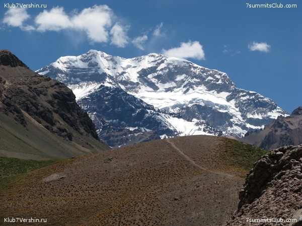
Every year, about 3,000 climbers attempt to climb Aconcagua. They climb two gorges from two base camps. However, the routes at the top are the same. Success reaches about half of the participants. This is due to the lack of readiness of climbers. And partly with the attitude of local guides, who are not inclined to take risks and are ready to turn the whole group or individual participants at any opportunity. So we highly recommend joining a group led by visiting, Russian-speaking guides. Better - from our company ...
Aconcagua climbing programs are getting more expensive from year to year due to the policies of local authorities. So don't delay.

*******
Denali (6194 m) - the highest peak of the mainland of North America. Located in the USA, in the state of Alaska, near the Arctic Circle. A typical ascent takes approximately three weeks, of which two weeks is hard work in the glacier zone, in conditions close to extreme. Participants are required to use purely mountaineering skills to a greater extent than on other peaks of the "seven". At the same time, all goods must be carried independently, including recycled waste. And when organizing a trip to Denali, you will have to solve a puzzle with obtaining an official permit and an American visa. All this is not at all difficult if you start in time.

In recent years, the number of climbers who aim to climb Denali has stabilized at around 1,500 per year. A season is considered successful when the percentage of "climbing" is above 50%. Most of the ascents are made in June - the first half of July. In the middle of summer, due to the state of the glacier, flights on airplanes become dangerous and stop by the beginning of August.
The American authorities issue permission to organize commercial programs only to a few companies and only with an American “registration”. For us, this means the need to use American guides under an agreement with one of the local companies. Let's face it, agreeing on all the details of interaction with them was not a smooth process. The difference in the mentality of our two mountaineering schools is very significant, but now mutual understanding has already been achieved and the problems are in the past.

*******
Kilimanjaro (5895 m) is the highest peak of the African continent and part of the world. The mountain is located in Tanzania, not far from the border with Kenya and from the equator. She is considered the highest single standing top peace. local national park strictly regulates ascents and allocates a limited number of days for expeditions, on average a week. At the same time, one of the goals is to ensure maximum employment local population working in service groups. Therefore, for one climber there are two or even more employees of the host companies.

Mount Kilimanjaro is located in the equatorial climate zone. The temperature difference between seasons is minimal. Practically climbing can be done all year round.
Due to the limited time, the ascent is carried out without sufficient acclimatization, which complicates the task of reaching the summit for an unprepared person. And these are the vast majority. Therefore, the ascent to the highest point can be done by no more than one third of the visitors. At the same time, almost all representatives of our country reach the top. What affects here: the power of salt or greed (money paid)?
In any case, a trip to Kilimanjaro is an exciting adventure, getting to know the amazing nature of Africa and its people is simply amazing. This The best way fall in love with the "black continent", which many are wary of. And, of course, we consider it obligatory to include in the program the so-called "safaris", excursions in national parks.

*******
Elbrus (5642 m) is the highest peak in Europe. The mountain is located in Russia, a little north of the Main Caucasian Range and, accordingly, from the border with Georgia. Climbing in favorable conditions requires only elementary climbing skills and is available to all physically healthy people. However, the load will still be serious, and the effect of height will make itself felt. The recommended time for the Elbrus climbing program is 9 days.

There is a fairly developed infrastructure that provides relatively comfortable living conditions for all days, except for the day of ascent.
Elbrus is still a territory of freedom. In this regard, only Kosciuszko can compare with him. Attempts to introduce payments do not meet with understanding from the majority of climbers.
There are no general statistics on Elbrus. An approximate estimate of the number of climbers is 25-30 thousand per year. The vast majority rises in July and August.

Programs of the Club 7 Peaks on Elbrus
*******
The Vinson Massif (4897 m) is the highest peak of the part of the world and the mainland of Antarctica. The mountain is located on an amazing icy continent, which so far belongs to all mankind. However, in the region of the very top, the absolute owner is the ALE (Antarctic Logistic Expedition) company, which determines the “rules of the game” here. But even the simplest calculations, how long the ascent will last, they are not able to do, the real schedule of "flights" is dictated by unpredictable weather.

Since the cost of an expedition to the Vinson Massif is very significant, only serious people get to its foot. And, as a rule, they successfully ascend, having overcome the terrible cold and wind.
It is important to dress properly. But this is also checked.

*******
And the highest point of the part of the world and the continent of Australia, coupled with the colossal area of Oceania, is represented by two options: the Karstensz Pyramid and Mount Kosciuszko.
Pyramid Karstensz, she, in the Indonesian way, Punchak Jaya (4884-5 m, on some maps even 5030 m) is the highest peak in Australia and Oceania. Located on the island of New Guinea. The most politically problematic mountain of the Seven Peaks, which had been simply closed to the public for 10 years before. It is a rocky ridge of considerable length, located above the humid tropical jungle. Climbing and descending requires skills in working with climbing equipment, with a rope. However, as part of a group and under the guidance of experienced instructors, overcoming difficult rocky areas is quite possible for any person.

The helicopter version has also existed for quite a long time, in which the base camp is reached by a rotorcraft. However, there are pitfalls here as well. Bad weather is a daily occurrence here, every flight is in danger of being disrupted.

On Earth, there are fourteen mountain peaks with a height of more than eight thousand meters. All these peaks are in Central Asia. But most of the highest mountain peaks are in the Himalayas.
They are also called the "roof of the world." Climbing such mountains is a very dangerous occupation. Until the middle of the last century, it was believed that mountains above eight thousand meters were inaccessible to humans.
We have compiled a rating of ten, which includes the highest mountains in the world.
It is also customary to single out the 7 highest mountain peaks in the world, one for each part of the world. Climbers who have conquered all these mountains are included in the honorary Seven Summits Club.
There are 2 main lists of the seven peaks of the world. More difficult to climb is the list compiled by the Italian climber Reinhold Messner. In this list, in addition to Asia, Europe, South and North America, Africa, Antarctica, not Australia appears as part of the world, but Australasia, i.e. region including Australia, New Guinea, New Zealand and adjacent islands Pacific Ocean. Accordingly, instead of the highest peak in Australia - Mount Kosciuszko, whose height is only 2228 meters and which is very easy to conquer, the list includes Mount Jaya in New Guinea, whose height is 4884 meters and which was first conquered only in 1962. The list, compiled by the American climber Richard Bass, is more traditional in terms of Russian geography, it lists Australia as part of the world, not Australasia.
Thus, the highest peaks of the world become not seven, but eight. In some interpretations, there are even nine of them, because. between geographers there are still disagreements about the border between Europe and Asia, so the highest peak in Europe is either Elbrus in the Russian Caucasus, or Mont Blanc in the Alps.
TOP 10 HIGHEST MOUNTAINS IN THE WORLD:
Annapurna - 8091 m .jpg)
This peak opens the top ten highest mountains of our planet. Annapurna is very famous and famous, it is the first Himalayan eight-thousander that was conquered by people. For the first time, people climbed its summit back in 1950. Annapurna is located in Nepal, the height of its peak is 8091 meters.
The mountain has as many as nine peaks, on one of which (Machapuchare), a human foot has not yet set foot. The locals consider this peak to be the sacred abode of Lord Shiva. Therefore, climbing it is prohibited. The highest of the nine peaks is called Annapurna 1. Annapurna is very dangerous, climbing to its peak took the lives of many experienced climbers.
Nanga Parbat - 8125 m
This mountain is the ninth highest on our planet. It is located in Pakistan and has a height of 8125 meters. The second name of Nanga Parbat is Diamir, which translates as "Mountain of the Gods". For the first time they were able to conquer it only in 1953. There were six unsuccessful attempts to climb the summit. A lot of climbers died while trying to climb this mountain peak.
In terms of mortality among climbers, it ranks a mournful third after K-2 and Everest. This mountain is also called the "killer".
Manaslu - 8156 m .jpg)
This eight-thousander ranks eighth on our list of the highest mountains in the world. It is also located in Nepal and is part of the Mansiri-Himal mountain range.
The height of the peak is 8156 meters.
The top of the mountain and the surrounding countryside are very picturesque. It was first conquered in 1956 by a Japanese expedition. Tourists love to visit here. But to conquer the summit, you need a lot of experience and excellent preparation. When trying to climb Manaslu, 53 climbers died.
Dhaulagiri - 8167 m
Mountain peak, which is located in the Nepalese part of the Himalayas. Its height is 8167 meters. The name of the mountain is translated from local language like a white mountain. Almost all of it is covered with snow and glaciers. Dhaulagiri is very difficult to climb. She was able to conquer in 1960. Climbing this peak took the lives of 58 experienced (others do not go to the Himalayas) climbers.
Cho Oyu - 8201 m
Another Himalayan eight-thousander, which is located on the border of Nepal and China. The height of this peak is 8201 meters. It is considered not too difficult to climb, but despite this, it has already taken the lives of 39 climbers and ranks sixth on our list of the highest mountains on our planet.
Makalu - -8485 m .jpg)
The fifth highest mountain in the world is Makalu, the second name of this peak is the Black Giant. It is also located in the Himalayas, on the border of Nepal and China and has a height of 8485 meters. It is located nineteen kilometers from Everest. This mountain is incredibly difficult to climb, its slopes are very steep.
Only a third of the expeditions that have the goal of reaching its summit are successful. During the ascents to this peak, 26 climbers died.
Lhotse - 8516 m
Another mountain located in the Himalayas and having a height of more than eight kilometers. Lhotse is located on the border between China and Nepal. Its height is 8516 meters. It is located at a distance of three kilometers from Everest. For the first time, they were able to conquer this mountain only in 1956.
Lhotse has three peaks, each of which is over eight kilometers high. This mountain is considered one of the highest, most dangerous and difficult peaks to climb.
Kanchenjunga - 8585 m
This mountain peak is also located in the Himalayas, between India and Nepal. This is the third highest mountain peak in the world: the height of the peak is 8585 meters. The mountain is very beautiful, it consists of five peaks. The first ascent to it took place in 1954.
The conquest of this peak cost the lives of forty climbers.
Chogori (K-2) - 8614 m .jpg)
Chogori is the second highest mountain in the world. Its height is 8614 meters. K-2 is located in the Himalayas, on the border of China and Pakistan. Chogori is considered one of the most difficult mountain peaks to climb; it was only possible to conquer it in 1954.
Of the 249 climbers who climbed its summit, 60 people died. This mountain peak is very picturesque.
Everest (Chomolungma) - 8848 m .jpg)
This mountain peak is located in Nepal. Its height is 8848 meters. Everest is the highest mountain peak in the Himalayas and our entire planet. Everest is part of the Mahalangur-Himal mountain range.
This mountain has two peaks: northern (8848 meters) and southern (8760 meters). The mountain is stunningly beautiful: it has the shape of an almost perfect trihedral pyramid. It was possible to conquer Chomolungma only in 1953. During attempts to climb Everest, 210 climbers died.
Nowadays, climbing the main route is no longer a problem, however, on high altitude daredevils expect a lack of oxygen (the fire almost does not burn here), heavy winds and low temperatures (below sixty degrees). To conquer Everest, you need to spend at least $8,000.

As a rule, the highest peaks of the Sikhote-Alin have a sharply defined contour and are covered with large stone placers in vast areas. The relief forms resemble badly destroyed circuses and mountain glaciation karts.
They are composed of sandy-shale deposits with numerous breakthroughs of intrusions, which led to the presence of deposits of gold, tin and polymetals. IN tectonic depressions within the Sikhote-Alin deposits of black and brown coal.
In the foothills, basalt plateaus are common, of which the largest plateau in terms of area is west of Sovetskaya Gavan. Plateau areas are also found on the main watershed. The largest is the Zevinsky plateau, on the watershed of the upper reaches of the Bikin and the rivers flowing into the Tatar Strait. In the south and east, the Sikhote-Alin is represented by steeply sloping mid-mountain ranges, in the west by numerous longitudinal valleys and basins, and at altitudes of more than 900 m - bald mountains. In general, the Sikhote-Alin has an asymmetric transverse profile. The western macroslope is more gentle than the eastern one. Accordingly, the rivers flowing to the west are longer. This feature is reflected in the very name of the ridge. Translated from the Manchu language - the ridge of large western rivers.
№ Mountain Altitude (m)
1 Tordoki Yani 2090 Khabarovsk region, Nanai district
2 Ko 2003 Khabarovsk Territory, district named after Lazo
3 Yako-Yani 1955 Khabarovsk Territory
4 Anik 1933 Primorsky Territory, Pozharsky District
5 Durhe 1903 Khabarovsk Territory, district named after. Lazo
6 Cloudy 1855 Primorsky Krai, Chuguevsky district
7 Bolotnaya 1814 Primorsky Territory, Pozharsky District
8 Sputnik 1805 Khabarovsk Territory, district im. Lazo
9 Acute 1788 Primorsky Territory, Terneisky District
10 Arseniev 1757 Primorsky Territory, Pozharsky District
11 High 1745 Primorsky Krai,
12 Snezhnaya 1684 Primorsky Territory, Chuguevsky District
13 Alder 1668 Primorsky Territory, Partizansky District
14 Lysaya 1554 Primorsky Territory, Partizansky/Lazovsky districts
15 Taunga 1459 Khabarovsk Territory
16 Izyubrinaya 1433 Primorsky Territory

The inner ridge is much lower than the Main one (up to 600 - 760 m above sea level). It stretches parallel to the Main and is separated from it by an inter-ridge depression of 10 - 25 km. In some places there are isolated low mountains and short, flat-topped ridges formed by erosion of the Inner Range. These are the remnant mountains Mangup, Eski-Kermen, Tepe-Kermen and others - natural bastions on which fortress cities were built in the Middle Ages.

Above sea level is about 250 m, the maximum is 325 m. It lies to the north of the Inner and is separated from it by a depression 3 to 8 km wide. The outer ridge is most clearly expressed between Simferopol and Sevastopol. It gradually decreases to the north and imperceptibly passes into the Plain Crimea.
The Inner and Outer Ridges are not only lower than the Main Ridge, but are also distinguished by a flat, even surface, slightly inclined to the northwest. It is they who form the foothills of the Crimean mountains.
On the Kerch Peninsula, two regions are distinguished, delimited by the low Parpach Ridge. In the southwest it is an undulating plain with a variety of isolated uplands, in the northeast it is a hilly-ridged area.
The soils of Crimea are very diverse. Each physical-geographical region has its own species. Solonetzic and solonetzic soils predominate in the Sivash region; to the south, in the flat part of the peninsula, there are chestnut and so-called southern chernozems (heavy loamy and clayey with underlying loess-like rocks); mountain-meadow and mountain chernozems have formed on the yayla; on the slopes of the Main Ridge, covered with forests, brown mountain-forest soils are common. special brown soils similar to subtropical red soils.
The name Tien Shan in Chinese means "heavenly mountains". According to E. M. Murzaev, this name is a tracing paper from the Turkic Tengritag, formed from the words: Tengri (Sky, God, divine) and tag (mountain).
The Tien Shan system includes the following orographic regions:
Northern Tien Shan: Ketmen, Zailiysky Alatau, Kungei-Alatau and Kirgizsky ridges;
Eastern Tien Shan: Borohoro, Iren-Khabyrga, Bogdo-Ula, Karlyktag Halyktau, Sarmin-Ula, Kuruktag ridges
Western Tien Shan: Karatau, Talas Alatau, Chatkal, Pskem and Ugam ranges;
Southwestern Tien Shan: ridges framing the Fergana Valley and including the southwestern slope of the Fergana Range;
Inner Tien Shan: from the north it is bounded by the Kirghiz ridge and the Issyk-Kul basin, from the south by the Kokshaltau ridge, from the west by the Ferghana ridge, from the east by the Akshiyrak mountain range.
The Tien Shan Mountains are considered one of the highest in the world, among them there are more than thirty peaks over 6000 meters high. The highest point of the mountain system is Pobeda Peak (Tomur, 7439 m), located on the border of Kyrgyzstan and Xinjiang Uygur autonomous region China; the next in height is the Khan-Tengri peak (6995 m) on the border of Kyrgyzstan and Kazakhstan.
Three mountain ranges diverge from the Central Tien Shan to the west, separated by intermountain basins (Issyk-Kul with Lake Issyk-Kul, Naryn, At-Bashyn, etc.) and connected in the west by the Ferghana Range.

In the Eastern Tien Shan there are two parallel mountain ranges (height 4-5 thousand meters), separated by depressions (height 2-3 thousand meters). Highly elevated (3-4 thousand m) leveled surfaces - syrts are characteristic. total area glaciers - 7.3 thousand km², the largest is South Inylchek. rapids rivers- Naryn, Chu, Ili, etc. Mountain steppes and semi-deserts dominate: on the northern slopes of the meadow-steppe and forests (mainly coniferous), higher subalpine and alpine meadows, on the syrts the so-called cold deserts.
From west to east is 2500 km. Mountain system in Wed. and Center. Asia. Length from 3. to E. 2500 km. Alpine folding, the remains of ancient leveled surfaces are preserved at an altitude of 3000-4000 m in the form of syrts. Modern tectonic activity is high, earthquakes are frequent. The mountain ranges are composed of igneous rocks, and the basins are composed of sedimentary rocks. Deposits of mercury, antimony, lead, cadmium, zinc, silver, in the basins - oil.
The relief is predominantly alpine, with glacial forms, scree, above 3200 m permafrost is common. There are flat intermountain basins (Fergana, Issyk-Kul, Naryn). The climate is continental, temperate. Snowfields and glaciers. The rivers belong to the basins of internal flow (Naryn, Ili, Chu, Tarim, etc.), lakes. Issyk-Kul, Song-Kel, Chatyr-Kel.
The first European explorer of the Tien Shan in 1856 was Pyotr Petrovich Semyonov, who received the title "Semyonov-Tyan-Shansky" for his work.

PIK PUTIN
Prime Minister of Kyrgyzstan Almazbek Atambayev signed an order to name one of the peaks of the Tien Shan named after Russian Prime Minister Vladimir Putin.
"The height of this peak reaches 4,500 meters above sea level. It is located in the Ak-Suu river basin, on the territory of the Chui region," the office of the head of the Kyrgyz government said.
One of the peaks of the Tien Shan in the Issyk-Kul region of Kyrgyzstan bears the name of the first president of Russia, Boris Yeltsin.
The Zugspitze is the most high mountain Germany
Bavaria does not claim to be the "roof of the world". But here, in Bavaria, snow-capped peaks rocks even in summer is the norm. For example, Mount Zugspitze - the highest mountain in Germany, is located precisely in the Bavarian Alps. From here, in winter and summer, an endless exciting prospect opens up to the snow-covered world of the rocky Alps. The height of the Zugspitze is 2964 meters.
This peak is located on the very border of the Austrian Tyrol and German Bavaria. The summit was conquered not so long ago, almost 200 years ago. Today it takes about 15 minutes to get to the peak by funicular or about 60 minutes (with transfers) by special train. This climb is very impressive. Even we, local residents, guides and tour guides, perceive this beauty every time, as if for the first time.
Mount Zugspitze is the highest mountain in Germany, therefore, if you choose the town of Garmisch-Patenkirchen as a starting point for this peak, then when climbing the Zugspitze, a special train will make a couple of intermediate stops, at which those tourists who prefer to “conquer” although the last few hundred meters on foot (in winter, these are skiers who do not need to climb the very peak). At the very top, amazingly fresh clean air. Here our guests have the opportunity to see enough of the beauty of the surrounding mountains and territories, wander, enjoy thrill chosenness. Those who wish can take pictures with an automatic camera mounted on the top of the observation deck. To do this, stand at a marked point on the terrace and press the button located at hand. Everything, the photo is ready! Then, below, pick up ready-made photos or send them immediately in electronic form to friends or parents / children.
How to get from Munich to the Zugspitze in Garmisch-Partenkirchen
There are several options for how this can be done. Choose the one that suits your wallet and soul:
1. If you are not burdened with luggage and the habit of comfortable movement, then you can buy a train ticket and get directly to the city of Garmisch-Partenkirchen, from which, already by funicular, or by a special train, climb the Zugspitze.
2. You can, of course, take a car at any Munich rental office and leisurely, exploring the surroundings, get to Garmisch-Partenkirchen, and even better to the village of Grainau and the Eibsee lake, which is located on its outskirts, on the shore of which there is both parking and beautiful views, leave the car at the foot of the Alps and climb the Zugspitze.
Poland
The highest mountains in Poland are the Tatras, a mountain range that forms the natural border between Slovakia and Poland. Peaks Gerlachovsky Shtit (Slovakia) and Rysy (Poland) represent the highest points in these countries. We suggest you go on a photo tour of the Tatra Mountains. The Tatras cover an area of 750 sq. km, most of which (600 sq. km) lies on the territory of Slovakia, and the highest point - Gerlachovsky Shtit (2655 m) is located north of Poprad.
In turn, the Rysy (2499 m) are located in the northwestern part of the Tatras. This is the highest point in Poland. The Tatras lie in the temperate zone Central Europe. This is an important barrier to air masses. Their mountain typography is the source of one of the most diverse climates in the region. Temperatures range from 40°C in winter to 33°C during the warmer months.
The temperature also depends on the altitude and the sunny side. Temperatures below 0°C stay at the peaks for 192 days. The mountains have a very diverse world of flora. More than 1000 species of vascular plants grow here, about 450 species of moss, 200 species of liverwort, 700 lichens, 900 fungi and 70 slime molds.
The Tatras have five climatic zones. The animal kingdom here is no less diverse: 54 tardigrades, 22 turbellarian species, 100 rotifer species, 22 copepod species, 162 spider species. 81 species of mollusks, 43 species of mammals, 200 species of birds, 7 species of amphibians and 2 species of reptiles. The Polish part of the Tatras was declared a national park in 1955. The lower parts of the mountains are overgrown with forest.
Mountains of Kazakhstan
Dzungarian Alatau is another famous mountain system of Kazakhstan. In some places, the peaks reach a height of 4500 meters or more. At this height, there are eternal ice. IN western parts The mountains are inhabited by rare species of animals: goitered gazelles, argali and mountain goats. The fame of this area was brought not only by endangered species of animals and the eternally snowy peaks of the mountains, but also by history.
were found in the mountains cave drawings ancient Central Asian nomads and grave burials, which are already more than 2000 years old! The Tien Shan Mountains in Kazakhstan are located in the southeast. Some of the animals that live here are listed in the Red Book - this is the Tien Shan bear and the snow leopard. The Tien Shan Mountains are famous for the Khan Tengri peak, which is considered one of the highest in the world. Its height is 7010 m, taking into account the ice sheet. Without it, the mountain is 15 meters lower. Average Height local mountains exceeds the mark of 4000 meters.
Another the most beautiful place is the Turgen Gorge, known as the Land of Waterfalls. There are many springs, hot springs, waterfalls and lakes with the purest water. A small river Assy flows nearby. Subalpine and alpine meadows roll down the slopes of the mountains. Not far from these places, there are Saka graves that hide the ancient secrets of nomads. Bayanaul Mountains Separately, I would like to say about these mountains, which cover the south-west of the country. Their dimensions are small - only about 50 km from west to east and about 25 km from north to south. The highest point is located at 1027 meters above sea level and is called Akbet. The mountains themselves are located on the left bank of the Irtysh River. This is very unusual mountains: layered, rounded, practically without steep slopes. Interesting fact: for millions of years of existence of the mountain range, not a single stony rock has been covered with moss or vegetation.
Bazarduzu, Azerbaijan
Coordinates: 41°13′16″ s. sh. 47°51′29″ E d.
Height: 4466 m
Translated from the Turkic language, "Bazarduzu" is translated as "Turn to the bazaar." So interesting name the mountain is obliged to the fair held in the Shahnabad valley. Numerous merchants and buyers, representatives of various nations, gathered here.
And Lezgins, and Nogais, and Armenians, Arabs, Persians, Jews and many others. The mountain, towering above all other peaks, is an excellent landmark for merchants from distant lands. The caravan approached the Bazarduzu glacier, and the drovers knew that from here it was necessary to turn left and here it was, the market square.
By the way, the local Lezgins call the mountain "Kichensuv", which translates as the Mountain of Fear.
Bazarduzu is not completely located in Azerbaijan, most of it lies on the territory of Russia. Therefore, the mountain is also the highest point of Dagestan (Republic of Dagestan).
Despite this, officially, Bazarduzu is the highest mountain in the country. Located on the Main Caucasian ridge mountain system of the Greater Caucasus, the mountain has a height of 4466 meters. This is the top of the watershed range and the last massif extending to the east. After the gradual lowering of the relief begins, the slope is covered with the channels of numerous rivers. At the beginning of the 20th century, there were eight glaciers, the largest of which was called Tikhitsar. The total area of people was about 13.8 square kilometers. Now there are several small glaciers and a firn cap with an area of 3.6 square kilometers (firn is an intermediate state between snow and ice, dense, packed long-term snow). The Bazardyuzyu glaciers are the easternmost group of glaciers throughout the Main Caucasus.
Weathering processes play an important role in shaping the appearance of the mountain. Therefore, the slopes of the summit are very beautiful. A little lower are alpine meadows, where thousands of sheep and goats feed during the summer months. Chamois, roe deer, herds of the Dagestan tur are preserved here. There is even such a rarity as mountain turkeys.
The first ascent, officially recorded in the documents, was the conquest of the mountain by a topographer from Russia, Sergei Timofeesich Aleksandrov. In May 1849, he single-handedly climbed and installed a triangulation tower on top.
Azerbaijani sportsmen Turan Akhmedov and Rusif Bagirov can be mentioned as another record. They made the ascent and descent in just 9 hours. This is the local speed climb record.
Moldoveanu, Romania
Mountain in Romania. The height above sea level is 2544 m, which makes the mountain the highest point in the country. Moldoveanu is located in the very center of Romania, in the Fagaras mountain range (Southern Carpathians) in the Argesh county. Geologically composed of crystalline rocks. The mountain slopes are mostly covered coniferous forests, above are alpine meadows.
padesh
The highest point of the Carpathian massif is Poiana Rusca. Height - 1382 m. Geographically, the mountain belongs to the county of Timis (Romania).
Pop Ivan
Mountain in Ukrainian Carpathians, near the Hutsul Alps, one of the peaks of the Marmarosh mountain range. Height 1936.2 m. Located on the border of Ukraine and Romania. The top of the mountain is adjacent to the higher nameless one, 1937.7 meters. The shape is pyramidal, the northern and eastern slopes are steep. Small lakes can form seasonally around the mountain. In large areas there are meadows. Many rare plants grow.
Otiku
A pass in the Southern Carpathians on the Otik saddle between the valleys of the rivers Ryul Doamney (namely, its tributary, the Veselat river) and Dymbovitsa (Boyarkesu river) at the junction of the Ridge. Koltsy Kremenei, Muntsii Groapele, Muntsii Mezya (Boarkesu Ridge), and Kulme Piscanu of the Muntsii Izer-Pepush massif.
Budichevska Bolshaya
Mountain in the Ukrainian Carpathians, in the Chivchyna massif. Located in the Verkhovinsky district Ivano-Frankivsk region, south of the village of Burkut. Height 1677.9 m. The foot and slopes of the mountain are covered with forests, above - meadows. The slopes are steep. The summit is located on the main ridge of the Chivchinsky Mountains, has several spurs, especially the long northern spur. To the east is the highest peak of the Chivchinsky mountains - Chivchin (1769 m).
Bucegi
Mountain range in central Romania, part of the Southern Carpathians. Bucegi - one of the highest mountains in the country, Omu, their highest point, is only 39 m lower than Moldoveanu, the highest point of the country. Mountains are located south of the city Brasov. Geologically, the massif consists of three ranges - Bucegi, Laota and Piatra Craiului.
Vigorlat-Gutinsky ridge
The mountain range of the Carpathians, located on the territory of Ukraine, Slovakia and Romania. The length of the ridge within Ukraine is about 125 km, width - from 8 to 20 km. The valleys of the tributaries of the Tisza (Uzh, Latoritsa, Borzhava and Rika) divide the ridge into separate massifs - Vigorlat, Makovitsa, etc. From the north and northeast, the ridge is adjacent to the Berezno-Lipsha intermountain valley, from the south and southwest - to the Transcarpathian lowland. In the southeast it borders on the Khust-Solotvinskaya basin.
____________________________________________________________________________________________
SOURCE OF INFORMATION AND PHOTO:
Team Nomads
The highest mountains in the world.
Natural monuments of Russia | Protected Areas of Russia (Russian). oopt.aari.ru.
Mountain systems of the world.
http://top10a.ru/top-10-samyx-vysokix-gor-v-mire.html
https://www.smileplanet.ru/dostoprimechatelnosti/gory/
“Only mountains can be better than mountains,” so many brave men still try to storm the most high peaks or want to become the first conquerors. The mystery of the mountains, their mystery, silence among mountainous landforms, stories and legends about each mountain - it attracts people like a magnet. Many tribes still believe that the peak is the place where God lives.
The top 10 highest mountains have long been identified by mankind.
No. 10. Annapurna.
This mountain is located in the Himalayas, from Nepal. The extreme height is 8 km 91 m. It was conquered 65 years ago and became the first of the list of eight-thousanders that a person climbed. Annapurna is considered one of the most dangerous peaks among climbing professionals. For 65 years, about 40% of climbers have died on it.
No. 9. Mount Nanga Parbat.

It has a 2nd name: Diamir, which translates as "Lord of the Mountains." It is located near the city of Kashmir in Pakistan. A man conquered this peak in 1953, determining its height at 8 km 123 m. Roerich painted many of his paintings from this mountain, and Alexander the Great visited it. Many chronicles testify to the visit of these mountains by Tamerlane. It was in these places that Buddhism originated.
No. 8. Mount Oyu. This majestic peak is located in Nepal. Its height is 8 km 153 m. The Austrians conquered it in 1954. Oyu is part of the Nepal National Park.
No. 7. Mount Manaslu.

The name of this peak is translated as "soul". Its feature is a combination of black and white colors of limestone and granite, especially noticeable at the very top. A man got up and saw this beauty in 1956. The height of Manaslu is 8 km 156 m.
No. 6. The name of the mountain Dhaulagiri is translated as White Mountain.

Its peak is located at a distance of 8 km 167 m, and for the first time a person climbed it in 1960. It is very beautiful and picturesque early in the morning, under the rays of the sun, illuminating it from the peak of the peak to the foot.
No. 5. Mount "Black Giant" or Makalu, located in Nepal, has a height of 8 km 463 m.

It is very different from other Himalayan peaks. Makalu has a very steep relief and snow and ice are not retained on its slopes. That is why it clearly stands out against the general background of snow-capped mountains. This place is considered one of the most beautiful on the planet.
No. 4. Lhotse - mountains with three peaks. The height of the largest of them is 8 km 511 m.

A Swiss expedition reached this height in 1956. It is very majestic and popular among Nepalese tourists and travelers.
No. 3. The highest point of the Nepalese massif Kanchenjunga has highest point at a distance of 8 km 586 m.

The aborigines call it the South Height. Kanchenjunga is especially beautiful at sunset.
No. 2. Chogori is a Pakistani mountain, which ranks second among the highest mountains on the planet.

Her extreme point located at an altitude of 8 km 610 m. Climbing professionals consider climbing Chogori more difficult and dangerous than conquering Everest. According to statistics, more than 25% of professional climbers die here.
No. 1. Certainly the most famous beautiful mountain planets consider Chomolungma.

Its extreme point is at an altitude of 8 km 863 m. It was possible to climb this mountain back in 1953. Every year, about 500 people try to climb its peak. Only 70% of those who wish succeed. The rise can take more than 2 months. It can be considered sad that, due to its popularity, Chomolungma is considered the dirtiest skyscraper. It is estimated that a garbage dump with a capacity of about 120 tons appeared on its territory thanks to people.
A man who even conquers the peaks of the most majestic mountain ranges, must remain human and protect nature, love everything unique that is created around him.
Evgeny Marushevsky
freelancer, constantly travels the world
Many people will confidently show the highest mountain in the world. However, what about the second highest mountain after Everest?
Here are three points of view on which mountain to consider the second.
All mountains are in the Himalayas.


If there is a place in the world that deserves to be called the hall of the mountain kings, then this is right here.
Michael Palin
This is how a famous actor and traveler spoke about Karakorum. It is here that the second highest mountain in the world is located, if you count from sea level - Chogori or K2.
Located on the border of China and Pakistan, it is located in the state of Kashmir and belongs to mountain range Karakoram. Its other names: Dapsang, Godwin-Austin.
It is noteworthy that there was a long dispute regarding K-2, to which mountain system it should be attributed. Since the Himalayas and the Karakorum practically consist of one chain of mountains. As a result, a conference of scientists who gathered on this occasion decided to attribute Mount Chogori to Karakorum.
The height of the mountain is 8611 meters above sea level. This is only 237 meters below Everest. But if the highest mountain in the world could be conquered even by disabled people in prostheses and elderly climbers, then Chogori belongs to the most difficult system for climbers.


Peak name
The second name of Mount Chogori is K2. The letter K stands for Karakorum. Contrary to popular belief, the numbering has nothing to do with the height of the top. Just in this way, a European explorer marked the mountains in front of him:
- K1 - Marchebroom,
- K2 - Chogori,
- K3 - Broad Peak,
- K5 - Garshebrum I,
- K4 - Garshebrum II.
Of all the names, only K2 stuck.
By the way, on Soviet maps until 1960 the mountain was named after Godwin Austen. Further name - Chogori.
Interestingly, the Pakistani government charges climbers about $900 for climbing Mount K2.
Chogori - killer mountain
For the first time I encounter a mountain that cannot be climbed from any direction. Everest was a walk compared to K2.
Reinhold Messner
Why was Chogori called the killer mountain? Because not everyone she lets in to her peak. According to statistics, every fourth climber who dared to climb dangerous mountain, does not return home.
At the moment, Mount Chogori has been conquered only 300 times, of which about 70 attempts were the last for climbers. In terms of danger among the "eight-thousanders", that is, mountains with a height of 8000 m or more, K2 ranks second after the infamous Annapurna. The death rate of the summit is about 25%.


Why such a high death rate?
The features of the human body are such that when climbing to a height of more than 6000 meters, the body goes into survival mode. Sleep and rest, although they do not restore strength, but save their remnants, serve as energy savings.
If climbing a mountain depended only on a person, then one could still understand the failed climbing attempts. But at such a high altitude, much also depends on the speed of the wind, accidental failures in crevices or frostbite, an avalanche, or simply diseases that arose due to a lack of oxygen.
At altitudes above 6000 m, the oxygen content is less than 1/3 of the permissible value without risk to human health. And the temperature conditions on the mountain are severe: -50 ° C with warm air from Tibet! If it is not there, you have to be content with -60 ° C.
The icy surface of the mountain, unpredictable climate, the most technically difficult terrain for climbers lead to the fact that the mountain takes every fourth daredevil.


A history of ups and downs
The first attempt to conquer Chogori was made in 1902. Six Europeans led by E. Ekenstein and A. Crowley ventured to climb to a height of 6525 m.
The first expedition was not successful. Stormy weather prevented their plans from being realized. However, thanks to this attempt, it was possible to collect key information about the state of the Godwin-Austen glacier, which served as a reliable foundation for the chain of further ascents.
Seven years later, there will be a second attempt to climb the unconquered Chogori by an expedition led by the Duke of Abruzzi. But it also ends badly.
Progress was made in 1938, when the Americans set a record - 7925 m, and the next year - 8382. Tragic death members of the expedition, including Dudley Wolf, forced the climbers to turn back.
Victory in the Conquest of Chogori
The first successful ascent became possible only in 1954. Only a quarter of a century after the first attempt. The first climbers who conquered Chogori were the Italian climbers Lino Lacedeli and Aquile Compagnoni. From camp 9 they continued their ascent when they ran out of oxygen just 150 meters from the summit. Then, in spite of everything, the Italians continued on their way and were the first to reach K2.
The first lone climber to conquer Chogori without oxygen was Messner Reingold.
The first woman to climb K2 was Wanda Rutkiewicz (1986). If we take into account the ascent of Chogori without oxygen tanks, then the first woman was Gerlinde Kaltenbrunner.
Russian climbers conquered the second highest mountain in the world in 1997. And in 2007, the Russians made an incredible difficult climb By western slope mountains that no one has yet climbed.


The second highest mountain in the world in the ranking of mountain systems
If we compare mountain systems with each other, we get the following table of the highest mountains:
After Everest, which has a height of 8448 m, the second highest mountain that does not belong to the Himalayan system of mountain ranges is Communism Peak in the Pamirs, its height is 7495 m.
A Brief History of Ismail Somoni Peak
In the USSR, he was considered the most high mountain. Location of Communism Peak - Tajikistan. Today the mountain bears the name of Ismail Somoni.
Communism Peak was discovered in 1920 and mistakenly thought it was Garmo Peak. However, during the research, inconsistencies in height were found, so the mountain was renamed Stalin Peak.
The first ascent to Stalin Peak (former name) was made by Yevgeny Abalakov together with the Pamir expedition. Among women climbers, the first was Lyudmila Agranovskaya.
And in 1986, a winter ascent to the mountain was made for the first time.


The second highest mountain in the world: a comparison between the continents
The second highest mountain is in South America- Aconcagua. It is also the highest mountain in the southern and western hemisphere.
Aconcagua is located in the Andes mountain range. Its height is 6962 m.
Climbing Mount Aconcagua is easy. Most often, climbers climb the northern slope. On the other sides of the mountain, the climb will be more difficult.
The first person to conquer the six-thousander Aconcagua was an Englishman. His name was Edward Fitzgerald. He climbed the mountain with an expedition in 1897.


