The Caspian Sea is fresh or salt water. salt lakes
The Caspian Lake is one of the most unique places on Earth. It keeps many secrets connected with the history of the development of our planet.
Position on the physical map
The Caspian is an internal drainless salt Lake. The geographical position of the Caspian Lake is the continent of Eurasia at the junction of parts of the world (Europe and Asia).
The length of the lakeshore line is from 6500 km to 6700 km. Taking into account the islands, the length increases to 7000 km.
The coastal areas of the Caspian Lake are mostly low-lying. Their northern part is indented by the channels of the Volga and the Urals. The river delta is rich in islands. The surface of the water in these areas is covered with thickets. Swampiness of large areas of land is noted.
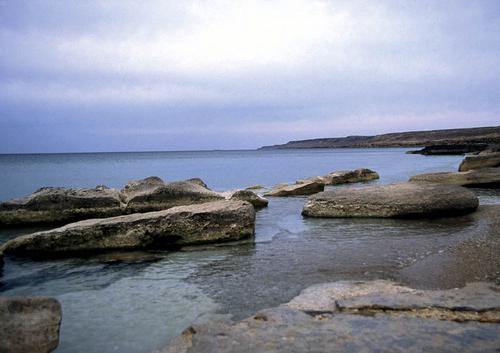
The eastern coast of the Caspian adjoins to the lake. There are significant limestone deposits on the shores of the lake. For western and part east coast characteristic curved coastline.
The Caspian lake on the map is represented by a significant size. The entire territory adjacent to it was called the Caspian Sea.
Some characteristics
The Caspian Lake in terms of its area and the volume of water in it has no equal on Earth. It stretches from north to south for 1049 kilometers, and its longest length from west to east is 435 kilometers.

If we take into account the depth of reservoirs, their area and volume of water, then the lake is commensurate with the Yellow, Baltic and Black Seas. By the same parameters, the Caspian surpasses the Tyrrhenian, Aegean, Adriatic and other seas.
The volume of water available in the Caspian Lake is 44% of the reserve of all lake waters of the planet.
Lake or sea?
Why is the Caspian lake called the sea? Is it really the impressive size of the reservoir that caused the assignment of such a “status”? More precisely, this was one of those reasons.
Others include a huge mass of water in the lake, the presence of a large wave during storm winds. All this is typical for real seas. It becomes clear why the Caspian Lake is called the sea.
But here one of the main conditions is not named, which must necessarily exist so that geographers can classify a reservoir as a sea. We are talking about the direct connection of the lake with the oceans. Exactly this condition The Caspian does not match.
Where the Caspian Lake is located, a deepening in the earth's crust was formed several tens of thousands of years ago. Today it is filled with the waters of the Caspian Sea. According to scientists, at the end of the 20th century, the water level in the Caspian Sea was 28 meters below the level of the World Ocean. direct connection the waters of the lake and the ocean ceased to exist approximately 6 millennia ago. The conclusion from the above is that the Caspian Sea is a lake.
There is another feature that distinguishes the Caspian Sea from the sea - the salinity of the water in it is almost 3 times lower than the salinity of the World Ocean. The explanation for this is that about 130 large and small rivers carry fresh water to the Caspian Sea. The Volga makes the most significant contribution to this work - it is she who “gives” up to 80% of all water to the lake.
The river played another important role in the life of the Caspian Sea. It is she who will help find the answer to the question of why the Caspian Lake is called the sea. Now that many channels have been built by man, it has become a fact that the Volga connects the lake with the oceans.
The history of the lake
modern look and geographical position The Caspian lake is caused by continuous processes occurring on the surface of the Earth and in its bowels. There were times when the Caspian was connected with the Sea of Azov, and through it with the Mediterranean and Black. That is, tens of thousands of years ago, the Caspian Lake was part of the World Ocean.

As a result of the processes associated with the uplift and lowering of the earth's crust, mountains appeared on the site of the modern Caucasus. They isolated a body of water that was part of a vast ancient ocean. More than one tens of thousands of years passed before the basins of the Black and Caspian Seas separated. But for a long time, the connection between their waters was carried out through the strait, which was on the site of the Kumo-Manych depression.
Periodically, the narrow strait was either drained or refilled with water. This was due to fluctuations in the level of the oceans and changes in the appearance of the land.
In a word, the origin of the Caspian Lake is closely connected with common history formation of the earth's surface.
Own modern name the lake received because of the tribes of the Caspians, who inhabited the eastern parts of the Caucasus and the steppe zones of the Caspian territories. Over the entire history of its existence, the lake had 70 different names.
Territorial division of the lake-sea
The depth of the Caspian Lake in its different places is very different. Based on this, the entire water area of the lake-sea was conditionally divided into three parts: the Northern Caspian, the Middle and the Southern.

Shallow - this is the northern part of the lake. The average depth of these places is 4.4 meters. The highest indicator is a mark of 27 meters. And on 20% of the entire area of the Northern Caspian, the depth is only about a meter. It is clear that this part of the lake is of little use for navigation.
The Middle Caspian has the greatest depth of 788 meters. The deep part occupies lakes. The average depth here is 345 meters, and the greatest is 1026 meters.
Seasonal changes at sea
Due to the large length of the reservoir from north to south, the climatic conditions on the coast of the lake are not the same. Seasonal changes in the territories adjacent to the reservoir also depend on this.

In winter south coast lakes in Iran, the water temperature does not fall below 13 degrees. During the same period, in the northern part of the lake off the coast of Russia, the water temperature does not exceed 0 degrees. The Northern Caspian is covered with ice during 2-3 months of the year.
In summer, almost everywhere the Caspian Lake warms up to 25-30 degrees. warm water, excellent sandy beaches, sunny weather create excellent conditions for people to relax.
Caspian on the political map of the world
Five states are located on the shores of the Caspian Lake - Russia, Iran, Azerbaijan, Kazakhstan and Turkmenistan.
The territory of Russia includes the western regions of the Northern and Middle Caspian. Iran is located on the southern shores of the sea, it owns 15% of the entire length of the coastline. Eastern line The coasts are shared by Kazakhstan and Turkmenistan. Azerbaijan is located in the southwestern territories of the Caspian Sea.
The issue of dividing the water area of the lake between the Caspian states has been the most acute for many years. The heads of the five states are trying to find a solution that would satisfy the needs and requirements of everyone.
The natural wealth of the lake
Since ancient times, the Caspian has served as a waterway for local residents.

The lake is famous for its valuable species of fish, in particular sturgeon. Their reserves account for up to 80% of the world's resources. The issue of preserving the sturgeon population is of international importance, it is decided at the government level littoral states.
The Caspian seal is another mystery of the unique sea-lake. Scientists have not yet fully unraveled the mystery of the appearance of this animal in the waters of the Caspian Sea, as well as other species of animals of northern latitudes.
In total, 1809 species live in the Caspian Sea various groups animals. There are 728 species of plants. Most of them are the "indigenous inhabitants" of the lake. But there is a small group of plants that were deliberately brought here by man.
Of the minerals, the main wealth of the Caspian is oil and gas. Some information sources compare the oil reserves of the Caspian Lake fields with Kuwait. Industrial marine mining of black gold has been carried out on the lake since the end of the 19th century. The first well appeared on the Apsheron shelf in 1820.
Today, the governments unanimously believe that the region cannot be considered only as a source of oil and gas, while leaving the Caspian ecology unattended.
In addition to oil fields, there are deposits of salt, stone, limestone, clay and sand on the territory of the Caspian Sea. Their production also could not but affect ecological situation region.
Sea level fluctuations
The water level in the Caspian Lake is not constant. This is evidenced by evidence relating to the IV century BC. The ancient Greeks who explored the sea discovered big bay at the confluence of the Volga. The existence of a shallow strait between the Caspian and the Sea of Azov was also discovered by them.
There are other data on the water level in the Caspian Lake. The facts show that the level was much lower than it is now. Ancient evidence is architectural structures found on seabed. The buildings date back to the 7th-13th centuries. Now the depth of their flooding is from 2 to 7 meters.
In 1930, the water level in the lake began to decline catastrophically. The process went on for almost fifty years. This caused great concern among people, since all the economic activities of the Caspian region are adapted to the previously established water level.
Since 1978 the level has started to rise again. Today it has become more than 2 meters taller. This is also an undesirable phenomenon for people living on the coast of the lake-sea.
Climate change is said to be the main reason for fluctuations in the lake. This results in an increase in volume river waters entering the Caspian Sea, the amount of precipitation, reducing the intensity of water evaporation.
However, it cannot be said that this is the only opinion that explains the fluctuations in the water level in the Caspian Lake. There are others, no less plausible.
Human activities and environmental issues
The area of the catchment basin of the Caspian Lake is 10 times larger than the surface of the water area of the reservoir itself. Therefore, all the changes taking place in such a vast territory in one way or another affect the ecology of the Caspian Sea.
Human activity plays an important role in changing the ecological situation in the area of the Caspian Lake. For example, pollution of a reservoir with harmful and hazardous substances occurs along with the influx of fresh water. This is directly related to industrial production, mining and other human activities in the catchment area.
State environment The Caspian Sea and the territories adjacent to it are of general concern to the governments of the countries located here. Therefore, the discussion of measures aimed at preserving the unique lake, its flora and fauna, has become traditional.
Each state has an understanding that only through joint efforts can the ecology of the Caspian Sea be improved.
The Caspian Sea is inland and is located in a vast continental depression on the border of Europe and Asia. The Caspian Sea has no connection with the ocean, which formally allows it to be called a lake, but it has all the features of the sea, since it had connections with the ocean in past geological epochs.
The area of the sea is 386.4 thousand km2, the volume of water is 78 thousand m3.
The Caspian Sea has a vast drainage basin, with an area of about 3.5 million km2. The nature of landscapes, climatic conditions and types of rivers are different. Despite its vastness, only 62.6% of its area is in waste areas; about 26.1% - for drainless. The area of the Caspian Sea itself is 11.3%. 130 rivers flow into it, but almost all of them are located in the north and west (and the eastern coast does not have a single river reaching the sea at all). The largest river in the Caspian basin is the Volga, which provides 78% of the river water entering the sea (it should be noted that more than 25% of the Russian economy is located in the basin of this river, and this undoubtedly determines many other features of the waters of the Caspian Sea), as well as the Kura River , Zhaiyk (Ural), Terek, Sulak, Samur.
In physical and geographical terms and according to the nature of the underwater relief, the sea is divided into three parts: northern, middle and southern. The conditional boundary between the northern and middle parts runs along the line of Chechen Island–Cape Tyub-Karagan, between the middle and southern parts - along the line of Zhiloy Island–Cape Kuuli.
The shelf of the Caspian Sea, on average, is limited to depths of about 100 m. The continental slope, which begins below the edge of the shelf, ends in the middle part at about 500–600 m, in the southern part, where it is very steep, at 700–750 m.
The northern part of the sea is shallow, its average depth is 5–6 m, the maximum depths of 15–20 m are located on the border with the middle part of the sea. The bottom relief is complicated by the presence of banks, islands, furrows.
The middle part of the sea is a separate basin, the region of maximum depths of which - the Derbent depression - is shifted to the western coast. The average depth of this part of the sea is 190 m, the greatest is 788 m.

The southern part of the sea is separated from the middle part by the Apsheron threshold, which is a continuation Greater Caucasus. Depths above this underwater ridge do not exceed 180 m. The deepest part of the South Caspian basin with a maximum sea depth of 1025 m is located east of the Kura delta. Several underwater ridges up to 500 m high rise above the bottom of the basin.
The shores of the Caspian Sea are diverse. In the northern part of the sea, they are quite strongly indented. Here are the bays of Kizlyar, Agrakhan, Mangyshlak and many shallow bays. Notable peninsulas: Agrakhansky, Buzachi, Tyub-Karagan, Mangyshlak. Large islands in the northern part of the sea are Tyuleniy, Kulaly. In the deltas of the Volga and Ural rivers, the coastline is complicated by many islets and channels, which often change their position. Many small islands and banks are located on other parts of the coastline.
The middle part of the sea has a relatively flat coastline. On west coast on the border with southern part Sea is the Absheron Peninsula. To the east of it, islands and banks of the Apsheron archipelago stand out, of which the largest is Zhiloy Island. The eastern shore of the Middle Caspian is more indented, the Kazakh Bay stands out here with the Kenderli Bay and several capes. The largest bay of this coast is Kara-Bogaz-Gol.

South of the Absheron Peninsula are the islands of the Baku archipelago. The origin of these islands, as well as some banks off the eastern coast of the southern part of the sea, is associated with the activity of underwater mud volcanoes lying at the bottom of the sea. On east coast located large bays Turkmenbashi and Turkmensky, and near it the island of Ogurchinsky.
One of the most striking phenomena of the Caspian Sea is the periodic variability of its level. In historical times, the Caspian Sea had a lower level than the World Ocean. Fluctuations in the level of the Caspian Sea are so great that for more than a century they have attracted the attention of not only scientists. Its peculiarity is that in the memory of mankind its level has always been below the level of the World Ocean. Since the beginning of instrumental observations (since 1830) of the sea level, the amplitude of its fluctuations has been almost 4 m, from -25.3 m in the eighties of the XIX century. to -29 m in 1977. In the last century, the level of the Caspian Sea has changed significantly twice. In 1929 it stood at a mark of about -26 m, and since it had been close to this mark for almost a century, this position of the level was considered as a long-term or secular average. In 1930, the level began to decline rapidly. Already by 1941, it had dropped by almost 2 m. This led to the drying up of vast coastal areas of the bottom. The decrease in the level, with its small fluctuations (short-term insignificant rises in the level in 1946-1948 and 1956-1958), continued until 1977 and reached the mark of -29.02 m, i.e., the level took the lowest position for last 200 years.

In 1978, contrary to all forecasts, the sea level began to rise. As of 1994, the level of the Caspian Sea was at -26.5 m, that is, in 16 years the level has risen by more than 2 m. The rate of this rise is 15 cm per year. The level increment in some years was higher, and in 1991 it reached 39 cm.
The general fluctuations in the level of the Caspian Sea are superimposed by its seasonal changes, the average long-term of which reaches 40 cm, as well as surge phenomena. The latter are especially pronounced in the Northern Caspian. The northwestern coast is characterized by large surges created by the prevailing, especially in the cold season, storms of eastern and southeastern directions. Over the past decades, a number of large (more than 1.5–3 m) surges have been observed here. A particularly large surge with catastrophic consequences was noted in 1952. Fluctuations in the level of the Caspian Sea cause great damage to the states surrounding its water area.


Climate. The Caspian Sea is located in the temperate and subtropical climatic zones. Climatic conditions change in the meridional direction, since the sea stretches for almost 1200 km from north to south.
In the Caspian region, various circulation systems interact, however, easterly winds prevail throughout the year (the influence of the Asian high). The position at rather low latitudes provides a positive balance of heat inflow, so the Caspian Sea serves as a source of heat and moisture for passing air masses for most of the year. The average annual temperature in the northern part of the sea is 8–10°С, in the middle part - 11–14°С, in the southern part – 15–17°С. However, in the northernmost parts of the sea, the average January temperature is from –7 to –10°C, and the minimum temperature during arctic air intrusions is up to –30°C, which determines the formation of the ice cover. In summer, rather high temperatures dominate over the entire region under consideration - 24–26°C. Thus, the Northern Caspian is subject to the most sharp temperature fluctuations.
The Caspian Sea is characterized by a very small amount of precipitation per year - only 180 mm, and most of it falls on the cold season of the year (from October to March). However, the Northern Caspian differs in this respect from the rest of the basin: here the average annual precipitation is less (only 137 mm for the western part), and the distribution over the seasons is more even (10–18 mm per month). In general, we can talk about proximity climatic conditions to the arid ones.
Water temperature. The distinctive features of the Caspian Sea (great differences in depths in different parts of the sea, the nature of the bottom relief, isolation) have a certain influence on the formation of temperature conditions. In the shallow North Caspian, the entire water column can be considered as homogeneous (the same applies to shallow bays located in other parts of the sea). In the Middle and South Caspian, surface and deep masses separated by a transitional layer can be distinguished. In the Northern Caspian and in the surface layers of the Middle and Southern Caspian, the water temperature varies over a wide range. In winter, temperatures vary from north to south from less than 2 to 10°С, the water temperature near the western coast is 1–2°С higher than near the eastern one, in the open sea the temperature is higher than near the coasts: by 2–3°С in the middle part and by 3–4°С in the southern part of the sea. IN winter period the temperature distribution with depth is more uniform, which is facilitated by the winter vertical circulation. During moderate and severe winters in the northern part of the sea and shallow bays on the east coast, the water temperature drops to freezing.

In summer, the temperature varies in space from 20 to 28°C. The highest temperatures are observed in the southern part of the sea; temperatures are also quite high in the well-warmed shallow North Caspian. The zone of distribution of the lowest temperatures is adjacent to the east coast. This is due to the rise of cold deep waters to the surface. Temperatures are also relatively low in the poorly heated deep-water central part. In the open areas of the sea, in late May–early June, the formation of a temperature jump layer begins, which is most clearly expressed in August. Most often it is located between 20 and 30 m in the middle part of the sea and 30 and 40 m in the south. In the middle part of the sea, due to the surge near the eastern coast, the shock layer rises close to the surface. In the bottom layers of the sea, the temperature during the year is about 4.5°C in the middle part and 5.8–5.9°C in the south.
Salinity. Salinity values are determined by such factors as river runoff, water dynamics, including mainly wind and gradient currents, the resulting water exchange between the western and eastern parts of the Northern Caspian and between the Northern and Middle Caspian, the bottom topography, which determines the location of waters with different salinity, mainly along the isobaths, evaporation, which ensures the shortage of fresh water and the inflow of more saline ones. These factors collectively affect the seasonal differences in salinity.
The Northern Caspian can be considered as a reservoir of constant mixing of river and Caspian waters. The most active mixing occurs in the western part, where both river and Central Caspian waters directly enter. In this case, horizontal salinity gradients can reach 1‰ per 1 km.
The eastern part of the Northern Caspian is characterized by a more uniform salinity field, since most of river and sea (Middle Caspian) waters enter this area of the sea in a transformed form.

According to the values of horizontal salinity gradients, in the western part of the Northern Caspian, a river-sea contact zone can be distinguished with water salinity from 2 to 10‰, in the eastern part from 2 to 6‰.
Significant vertical salinity gradients in the Northern Caspian are formed as a result of the interaction of river and sea waters, with runoff playing a decisive role. The intensification of vertical stratification is also facilitated by the unequal thermal state of the water layers, since the temperature of the surface desalinated waters coming from the coast in summer is 10–15°C higher than that of the bottom ones.
In the deep basins of the Middle and South Caspian, salinity fluctuations in the upper layer are 1–1.5‰. The largest difference between the maximum and minimum salinity was noted in the area of the Apsheron threshold, where it is 1.6‰ in surface layer and 2.1‰ at the horizon of 5 m.
The decrease in salinity along the western coast of the South Caspian in the 0–20 m layer is caused by the runoff of the Kura River. The influence of the Kura runoff decreases with depth; at the horizons of 40–70 m, the range of salinity fluctuations is no more than 1.1‰. Along the entire western coast to the Absheron Peninsula stretches a strip of desalinated water with a salinity of 10–12.5‰ coming from the Northern Caspian.
In addition, salinity increases in the South Caspian due to the removal of saline waters from bays and inlets on the eastern shelf under the action of southeasterly winds. In the future, these waters are transferred to the Middle Caspian.
In the deep layers of the Middle and South Caspian, salinity is about 13‰. In the central part of the Middle Caspian, such salinity is observed at horizons below 100 m, and in the deep part of the South Caspian, the upper boundary of waters with increased salinity drops to 250 m. Obviously, in these parts of the sea vertical mixing water is difficult.
Surface water circulation. Currents in the sea are mainly wind-driven. In the western part of the Northern Caspian, currents of the western and eastern quarters are most often observed, in the eastern - southwestern and southern. The currents caused by the runoff of the Volga and Ural rivers can be traced only within the estuarine coast. The prevailing current velocities are 10–15 cm/s; in the open areas of the Northern Caspian, the maximum velocities are about 30 cm/s.
IN coastal areas in the middle and southern parts of the sea, in accordance with the wind directions, currents of the northwestern, northern, southeastern and southern directions are observed; near the eastern coast, currents of the eastern direction often take place. Along the western coast of the middle part of the sea, the most stable currents are southeast and south. Current velocities are on average about 20–40 cm/s, the maximum ones reach 50–80 cm/s. Other types of currents also play a significant role in the circulation of sea waters: gradient, seiche, inertial ones.

ice formation. The Northern Caspian is covered with ice annually in November, the area of the freezing part of the water area depends on the severity of the winter: in severe winters, the entire Northern Caspian is covered with ice, in soft ice it stays within the 2–3 meter isobath. The appearance of ice in the middle and southern parts of the sea falls on December-January. Near the eastern coast, ice is of local origin, near the western coast - most often brought from the northern part of the sea. In severe winters, shallow bays freeze off the eastern coast of the middle part of the sea, coasts and landfast ice form off the coast, and drift ice spreads to the Absheron Peninsula in abnormally cold winters off the western coast. The disappearance of the ice cover is observed in the second half of February–March.
Oxygen content. The spatial distribution of dissolved oxygen in the Caspian Sea has a number of regularities.
The central part of the Northern Caspian is characterized by a fairly uniform distribution of oxygen. An increased oxygen content is found in the areas of the pre-estuary seashore of the Volga River, a lower one - in the southwestern part of the Northern Caspian.
In the Middle and South Caspian, the highest oxygen concentrations are confined to coastal shallow areas and pre-estuary seashores of rivers, with the exception of the most polluted areas of the sea (Baku Bay, Sumgait region, etc.).
In the deep-water regions of the Caspian Sea, the main pattern is preserved in all seasons - a decrease in oxygen concentration with depth.
Due to the autumn-winter cooling, the density of the waters of the North Caspian increases to a value at which it becomes possible for the flow of North Caspian waters with a high oxygen content along the continental slope to significant depths of the Caspian Sea.
The seasonal distribution of oxygen is mainly related to the annual course and seasonal ratio of production-destruction processes occurring in the sea.


In spring, the production of oxygen in the process of photosynthesis quite significantly covers the decrease in oxygen due to a decrease in its solubility with an increase in water temperature in spring.
In the areas of the estuarine coasts of the rivers feeding the Caspian Sea, in spring there is a sharp increase in the relative oxygen content, which in turn is an integral indicator of the intensification of the photosynthesis process and characterizes the degree of productivity of the mixing zones of sea and river waters.
In summer, due to significant warming of water masses and activation of photosynthesis processes, the leading factors in the formation of the oxygen regime in surface waters are photosynthetic processes, in near-bottom waters - biochemical oxygen consumption by bottom sediments.
Due to the high temperature of the waters, the stratification of the water column, the large influx of organic matter and its intense oxidation, oxygen is quickly consumed with its minimal entry into the lower layers of the sea, as a result of which an oxygen deficiency zone is formed in the Northern Caspian. Intensive photosynthesis in the open waters of the deep-water regions of the Middle and South Caspian covers the upper 25-meter layer, where oxygen saturation is more than 120%.

In autumn, in the well-aerated shallow water areas of the Northern, Middle and Southern Caspian, the formation of oxygen fields is determined by the processes of water cooling and the less active, but still ongoing process of photosynthesis. The oxygen content is rising.
The spatial distribution of nutrients in the Caspian Sea reveals the following patterns:
- increased concentrations of biogenic substances characterize the areas of pre-estuary seashores of rivers that feed the sea and shallow areas of the sea subject to active anthropogenic influence (Baku Bay, Turkmenbashi Bay, water areas adjacent to Makhachkala, Fort Shevchenko, etc.);
- The Northern Caspian, which is a vast mixing zone of river and sea waters, is characterized by significant spatial gradients in the distribution of nutrients;
- in the Middle Caspian, the cyclonic nature of the circulation contributes to the upwelling of deep waters with a high content of nutrients into the overlying layers of the sea;
- in the deep water areas of the Middle and South Caspian, the vertical distribution of nutrients depends on the intensity of the convective mixing process, and their content increases with depth.
The dynamics of nutrient concentrations during the year in the Caspian Sea is influenced by such factors as seasonal fluctuations in the biogenic runoff into the sea, the seasonal ratio of production-destruction processes, the intensity of exchange between soil and water mass, ice conditions in winter in the Northern Caspian, the processes of winter vertical circulation in the deep sea areas.
In winter, a significant area of the Northern Caspian is covered with ice, but biochemical processes are actively developing in the under-ice water and ice. The ice of the Northern Caspian, being a kind of accumulator of biogenic substances, transforms these substances entering the sea from and from the atmosphere.
As a result of the winter vertical circulation of waters in the deep-sea regions of the Middle and Southern Caspian in the cold season, the active layer of the sea is enriched with nutrients due to their supply from the underlying layers.
Spring for the waters of the North Caspian is characterized by a minimum content of phosphates, nitrites and silicon, which is explained by the spring outbreak of phytoplankton development (silicon is actively consumed by diatoms). High concentrations of ammonium and nitrate nitrogen, characteristic of the waters of a large area of the Northern Caspian during floods, are due to intensive flushing by river waters.
In the spring season, in the area of water exchange between the Northern and Middle Caspian in the subsurface layer, with the maximum oxygen content, the content of phosphates is minimal, which, in turn, indicates the activation of the photosynthesis process in this layer.
In the South Caspian, the distribution of nutrients in spring is basically similar to their distribution in the Middle Caspian.
In the summertime, the waters of the Northern Caspian reveal a redistribution of various forms of biogenic compounds. Here, the content of ammonium nitrogen and nitrates significantly decreases, while at the same time there is a slight increase in the concentrations of phosphates and nitrites and a rather significant increase in the concentration of silicon. In the Middle and South Caspian, the concentration of phosphates has decreased due to their consumption in the process of photosynthesis and the difficulty of water exchange with the deep water accumulation zone.
In autumn, in the Caspian Sea, due to the cessation of the activity of some types of phytoplankton, the content of phosphates and nitrates increases, and the concentration of silicon decreases, as an autumn outbreak of diatoms occurs.
Oil has been produced on the shelf of the Caspian Sea for more than 150 years.
Currently, large reserves of hydrocarbons are being developed on the Russian shelf, the resources of which on the Dagestan shelf are estimated at 425 million tons of oil equivalent (of which 132 million tons of oil and 78 billion m3 of gas), on the shelf of the Northern Caspian - 1 billion tons of oil .
In total, about 2 billion tons of oil have already been produced in the Caspian.
Losses of oil and products of its processing during extraction, transportation and use reach 2% of the total volume.
The main sources of pollutants, including oil products, entering the Caspian Sea are carry-over with river runoff, discharge of untreated industrial and agricultural effluents, domestic wastewater from cities and towns located on the coast, shipping, exploration and exploitation of oil and gas fields located at the bottom of the sea, transportation of oil by sea. 90% of pollutants with river runoff are concentrated in the Northern Caspian, industrial effluents are confined mainly to the area of the Apsheron Peninsula, and increased oil pollution of the Southern Caspian is associated with oil production and oil exploration drilling, as well as active volcanic activity (mud) in zone of oil and gas bearing structures.
From the territory of Russia, about 55 thousand tons of oil products enter the Northern Caspian every year, including 35 thousand tons (65%) from the Volga River and 130 tons (2.5%) from the Terek and Sulak rivers.
The thickening of the film on the water surface up to 0.01 mm disrupts the processes of gas exchange and threatens the death of hydrobiota. Toxic for fish is the concentration of oil products 0.01 mg/l, for phytoplankton - 0.1 mg/l.

The development of oil and gas resources of the bottom of the Caspian Sea, the estimated reserves of which are estimated at 12–15 billion tons of standard fuel, will become the main factor in the anthropogenic load on the ecosystem of the sea in the coming decades.
Caspian autochthonous fauna. The total number of autochthons is 513 species or 43.8% of the entire fauna, which include herring, gobies, mollusks, etc.
arctic views. The total number of the Arctic group is 14 species and subspecies, or only 1.2% of the entire fauna of the Caspian (mysids, sea cockroach, white salmon, Caspian salmon, Caspian seal, etc.). The basis of the Arctic fauna is crustaceans (71.4%), which easily tolerate desalination and live on great depths of the Middle and South Caspian (from 200 to 700 m), since the most low temperatures water (4.9–5.9°С).
mediterranean views. These are 2 types of mollusks, needle-fish, etc. At the beginning of the 20s of our century, the mollusk mitilyastra penetrated here, later 2 types of shrimp (with mullets, during their acclimatization), 2 types of mullet and flounder. Some Mediterranean species entered the Caspian after the opening of the Volga-Don Canal. Mediterranean species play a significant role in the fish food base of the Caspian Sea.

Freshwater fauna (228 species). This group includes anadromous and semi-anadromous fish (sturgeon, salmon, pike, catfish, cyprinids, as well as rotifers).
sea views. These are ciliates (386 forms), 2 species of foraminifera. There are especially many endemics among higher crustaceans (31 species), gastropod molluscs (74 species and subspecies), bivalve mollusks (28 species and subspecies) and fish (63 species and subspecies). The abundance of endemics in the Caspian Sea makes it one of the most unique brackish water bodies on the planet.
The Caspian Sea provides more than 80% of the world's sturgeon catch, most of which falls on the North Caspian.
To increase the catches of sturgeon, which dropped sharply during the years of sea level drop, a set of measures is being implemented. Among them - a complete ban on sturgeon fishing in the sea and its regulation in rivers, an increase in the scale of factory breeding of sturgeons.
I would be grateful if you share this article on social networks:
CaspAndmOre(Caspian) - the largest enclosed body of water on Earth. In size, the Caspian Sea is much larger than such lakes as the Upper, Victoria, Huron, Michigan, Baikal. According to formal features, the Caspian Sea is an endorheic lake. However, considering it big sizes, brackish waters and a regime similar to the sea, this body of water is called the sea.
According to one hypothesis, the Caspian Sea (among the ancient Slavs - the Khvalyn Sea) got its name in honor of the Caspian tribes who lived before our era on its southwestern coast.
The Caspian Sea washes the shores of five states: Russia, Azerbaijan, Iran, Turkmenistan and Kazakhstan.
The Caspian Sea is elongated in the meridional direction and is located between 36°33' and 47°07' N latitude. and 45°43΄ and 54°03΄ E (without Kara-Bogaz-Gol Bay). The length of the sea along the meridian is about 1200 km; the average width is 310 km. The northern coast of the Caspian Sea is bordered Caspian lowland, eastern - deserts Central Asia; in the west, the mountains of the Caucasus approach the sea, in the south, near the coast, the Elburz ridge stretches.
The surface of the Caspian Sea is much lower than the level of the World Ocean. Its current level fluctuates around -27 ... -28 m. These levels correspond to the sea surface area of 390 and 380 thousand km 2 (without the Kara-Bogaz-Gol Bay), the volume of water is 74.15 and 73.75 thousand km 3, average depth is about 190 m.
The Caspian Sea is traditionally divided into three large parts: the North (24% of the sea area), the Middle (36%) and the South Caspian (40%), which differ significantly in morphology and regime, as well as the large and isolated Kara-Bogaz-Gol Bay. The northern, shelf part of the sea is shallow: its average depth is 5–6 m, maximum depths are 15–25 m, and the volume is less than 1% of the total water mass of the sea. The Middle Caspian is a separate basin with the area of maximum depths in the Derbent depression (788 m); its average depth is about 190 m. In the South Caspian, the average and maximum depths are 345 and 1025 m (in the South Caspian depression); 65% of the water mass of the sea is concentrated here.
There are about 50 islands in the Caspian Sea with a total area of approximately 400 km2; the main ones are Tyuleniy, Chechen, Zyudev, Konevsky, Dzhambaysky, Durneva, Ogurchinsky, Apsheronsky. The length of the coastline is approximately 6.8 thousand km, with islands - up to 7.5 thousand km. The shores of the Caspian Sea are diverse. In the northern and eastern parts, they are quite strongly indented. There are large bays Kizlyarsky, Komsomolets, Mangyshlaksky, Kazakhsky, Kara-Bogaz-Gol, Krasnovodsky and Turkmensky, many bays; off the western coast - Kyzylagach. The largest peninsulas are Agrakhansky, Buzachi, Tyub-Karagan, Mangyshlak, Krasnovodsky, Cheleken and Apsheronsky. The most common banks are accumulative; areas with abrasion shores are found along the contour of the Middle and South Caspian.
More than 130 rivers flow into the Caspian Sea, the largest of which is the Volga. , Ural, Terek, Sulak, Samur, Kura, Sefidrud, Atrek, Emba (its runoff enters the sea only in high-water years). Nine rivers have deltas; the largest are located at the mouths of the Volga and Terek.
The main feature of the Caspian Sea, as a drainless reservoir, is instability and a wide range of long-term fluctuations in its level. This most important hydrological feature of the Caspian Sea has a significant impact on all its other hydrological characteristics, as well as on the structure and regime of river mouths, on coastal zones. In the Caspian Sea level varied in the range of ~200 m: from -140 to +50 m BS; in from -34 to -20 m BS. From the first third of the 19th century and until 1977, sea level dropped by about 3.8 m - to the lowest point in the last 400 years (-29.01 m BS). In 1978–1995 The level of the Caspian Sea rose by 2.35 m and reached -26.66 m BS. Since 1995, a certain downward trend has dominated - to -27.69 m BS in 2013.
During major periods, the northern shore of the Caspian Sea shifted to Samarskaya Luka on the Volga, and perhaps even further. At maximum transgressions, the Caspian turned into a sewage lake: excess water flowed through the Kuma-Manych depression into the Sea of Azov and further into the Black Sea. In extreme regressions South coast The Caspian was shifted to the Apsheron threshold.
Long-term fluctuations in the level of the Caspian are explained by changes in the structure of the water balance of the Caspian Sea. The sea level rises when the incoming part of the water balance (primarily river runoff) increases and exceeds the outgoing part, and decreases if the inflow of river waters decreases. The total water flow of all rivers averages 300 km 3 /year; while the five largest rivers account for almost 95% (the Volga provides 83%). During the period of the lowest sea level, in 1942–1977, the river flow was 275.3 km 3 / year (of which 234.6 km 3 / year is the flow of the Volga), precipitation - 70.9, underground flow - 4 km 3 /year, and evaporation and outflow to the Kara-Bogaz-Gol Bay - 354.79 and 9.8 km 3 /year. During the period of intensive sea level rise, in 1978-1995, respectively, 315 (Volga - 274.1), 86.1, 4, 348.79 and 8.7 km 3 / year; V modern period- 287.4 (Volga - 248.2), 75.3, 4, 378.3 and 16.3 km 3 / year.
The intra-annual changes in the level of the Caspian Sea are characterized by a maximum in June–July and a minimum in February; the range of intra-annual level fluctuations is 30–40 cm. Surge-surge level fluctuations are manifested throughout the sea, but they are most significant in the northern part, where, with maximum surges, the level can rise by 2–4.5 m and the edge “retreat” by several tens of kilometers inland, and in case of surges - to drop by 1–2.5 m. Seiche and tidal level fluctuations do not exceed 0.1–0.2 m.
Despite the relatively small size of the reservoir in the Caspian Sea, there is strong excitement. The highest wave heights in the South Caspian can reach 10–11 m. Wave heights decrease from south to north. Storm waves can develop at any time of the year, but more often and more dangerously in the cold half of the year.
The Caspian Sea is generally dominated by wind currents; nevertheless, runoff currents play an appreciable role on the estuarine coasts of large rivers. Cyclonic water circulation prevails in the Middle Caspian, and anticyclonic circulation in the South Caspian. In the northern part of the sea, the patterns of wind currents are more irregular and depend on the characteristics and variability of the wind, bottom topography and coastlines, river runoff and aquatic vegetation.
The water temperature is subject to significant latitudinal and seasonal changes. In winter, it varies from 0–0.5 o C at the ice edge in the north of the sea to 10–11 o C in the south. In summer, the water temperature in the sea averages 23–28 o C, and in shallow coastal waters in the Northern Caspian it can reach 35–40 o C. At depths, a constant temperature is maintained: deeper than 100 m it is 4–7 o C.
In winter, only the northern part of the Caspian Sea freezes; in severe winter - the entire Northern Caspian and the coastal zones of the Middle Caspian. Freezing in the Northern Caspian lasts from November to March.
The salinity of water changes especially sharply in the northern part of the sea: from 0.1‰ on the estuarine coasts of the Volga and Urals to 10–12‰ on the border with the Middle Caspian. In the Northern Caspian, the temporal variability of water salinity is also great. In the middle and southern parts of the sea, salinity fluctuations are small: it is mainly 12.5–13.5‰, increasing from north to south and from west to east. The highest water salinity is in the Kara-Bogaz-Gol Bay (up to 300‰). With depth, the salinity of water increases slightly (by 0.1–0.3‰). The average salinity of the sea is about 12.5‰.
More than a hundred species of fish live in the Caspian Sea and the mouths of the rivers flowing into it. There are Mediterranean and Arctic invaders. The object of fishing is goby, herring, salmon, carp, mullet and sturgeon fish. The latter number five species: sturgeon, beluga, stellate sturgeon, spike and sterlet. The sea is capable of producing up to 500-550 thousand tons of fish annually if overfishing is not allowed. From marine mammals the endemic Caspian seal lives in the Caspian Sea. Every year 5-6 million waterfowl migrate through the Caspian region.
The economy of the Caspian Sea is associated with oil and gas production, shipping, fishing, seafood, various salts and minerals (Kara-Bogaz-Gol Bay), using recreational resources. The explored oil resources in the Caspian Sea are about 10 billion tons, the total resources of oil and gas condensate are estimated at 18–20 billion tons. Oil and gas are being produced on an ever-increasing scale. Used by the Caspian Sea and water transport, including along the river-sea and sea-river routes. The main ports of the Caspian Sea: Astrakhan, Olya, Makhachkala (Russia), Aktau, Atyrau (Kazakhstan), Baku (Azerbaijan), Nowshahr, Bender-Enzeli, Bender-Torkemen (Iran) and Turkmenbashi (Turkmenistan).
Business activities and hydrological features The Caspian Sea creates a number of serious environmental and water management problems. Among them: anthropogenic pollution of river and sea waters (mainly with oil products, phenols and synthetic surfactants), poaching and reduction of fish stock, especially sturgeons; damage to the population and coastal economic activity due to large-scale and rapid changes in the level of the reservoir, the impact of numerous hazardous hydrological phenomena and hydrological and morphological processes.
The total economic damage for all the Caspian countries associated with the rapid and significant recent rise in the level of the Caspian Sea, the flooding of part of the coastal land, the destruction of coasts and coastal structures, was estimated at 15 to 30 billion US dollars. It took urgent engineering measures to protect the coast.
A sharp drop in the level of the Caspian Sea in the 1930s–1970s. led to less damage, but they were significant. The navigable approach channels became shallow, the shallow seashore at the mouths of the Volga and the Urals became heavily overgrown, which became an obstacle to the passage of fish into the rivers for spawning. It was necessary to build fish passages through the seasides mentioned above.
Among the unresolved problems is the lack of an international agreement on the international legal status of the Caspian Sea, the division of its water area, bottom and subsoil.
The Caspian Sea is the object of many years of research by specialists from all the Caspian states. Such domestic organizations as the State Oceanographic Institute, the Institute of Oceanology of the Russian Academy of Sciences, the Hydrometeorological Center of Russia, the Caspian Research Institute of Fisheries, the Faculty of Geography of Moscow State University, etc. took an active part in the study of the Caspian Sea.
The Caspian Sea is the most big lake on the ground. Its surface area is 371,000 square kilometers (143,244 sq mi) and its volume is 78,200 cubic kilometers (18,761 cu mi). This - drainless lake, and is between southern regions Russian Federation and northern Iran. Its maximum depth is approximately 1,025 meters (3,363 feet). This lake is called the sea because when the Romans arrived in this region, they tried to drink water from the lake and it turned out to be salty. The salinity at the lake is about 1.2%, which is about a third of the salinity of most sea water. The lake was named after the ancient Caspians.
 The Caspian Sea is the remnant of Tethys (the ancient ocean that separated the supercontinents in the Mesozoic era), along with the Black and Aral seas. The Caspian ceased to have access to the sea approximately 5.5 million years ago due to continental change. Depending on the inflow of fresh water, the Caspian Sea is freshwater lake in their northern parts. The Caspian Sea owes its salinity to its origin from the World Ocean. Freshwater tributaries have been responsible for the decrease in salinity, although its salinity still remains variable. At present, the salinity of the Caspian Sea is quite low - three times less than the water in the oceans of the Earth.
The Caspian Sea is the largest inland body of water in the world and accounts for 40 - 44 percent of the world's total lake waters. The coastlines of the Caspian Sea are divided between Azerbaijan, Iran, Kazakhstan, Russian Federation, and Turkmenistan. The Caspian Sea is divided into three distinct physical regions: the North, Middle, and South Caspian. The northern-middle border is the threshold of Mangyshlak, which runs along the Chechen Island and Cape Tyub-Karagan. The middle southern border is the threshold of the Apsheron Peninsula, which passes through Zhiloy Island and Cape Kuuli. The differences between these three areas are very striking. The North Caspian Sea is very shallow; and accounts for less than one percent of the total water volume, with an average depth of only five to six meters. The sea drops noticeably towards the Caspian Middle, where average depth is 190 meters. The South Caspian Sea is the deepest, with a depth that is up to 1000 meters. The Middle and South Caspian Seas account for 33% and 66% of the total water volume, respectively. The northern part of the Caspian Sea typically freezes over in winter, and in the coldest winters, ice forms near the coastline and in the south. More than 130 rivers supply the Caspian Sea, including the Volga River. The Caspian Sea also has several small islands; they are primarily located in the North and have total area approximately 2000 square kilometers. The Central Asian steppes stretch along the northeast coast, while the Caucasus skirts the West Bank. The north and east are characterized by cold, continental deserts.
 The main cities of the Caspian Sea
- Baku, Azerbaijan
- Gobustan, Azerbaijan
- Nabran, Azerbaijan
- Astara, Iran
- Rasht, Iran
- Sari, Iran
- Atyrau, Kazakhstan (formerly Guriev)
- Aktau, Kazakhstan (formerly Shevchenko)
- Astrakhan, Russia
- Derbent, Russia
- Turkmenbashi (Turkmenbasy), Turkmenistan (formerly Krasnovodsk)
- Khazar, Turkmenistan
- Makhachkala, Russia
Discoveries in the Khuto Cave near the city of Behshahr, in the south of Mazandaran in Iran, date human habitation in this area to 75,000 years ago. In the classical ancient period, the Greeks and Persians called the Caspian Sea the Ocean of Hyrcania. In Persia and modern Iran, the Caspian Sea is known as the Khazar or Mazenadaran Sea. In Turkic languages, it is known as the Khazar Sea.
The Caspian Sea is the largest lake on our planet, which is located in a depression on the earth's surface (the so-called Aral-Caspian lowland) on the territory of Russia, Turkmenistan, Kazakhstan, Azerbaijan and Iran. Although they consider it as a lake, because it is not connected with the World Ocean, but by the nature of the formation processes and the history of origin, in terms of its size, the Caspian Sea is a sea.
The area of the Caspian Sea is about 371 thousand km2. The sea, stretched from north to south, has a length of about 1200 km and an average width of 320 km. The length of the coastline is about 7 thousand km. The Caspian Sea is located 28.5 m below the level of the World Ocean and its greatest depth is 1025 m. There are about 50 islands in the Caspian Sea, mostly small in area. Large islands include such islands as Tyuleniy, Kulaly, Zhiloy, Chechen, Artem, Ogurchinsky. There are also many bays in the sea, for example: Kizlyarsky, Komsomolets, Kazakh, Agrakhansky, etc.
The Caspian Sea is fed by more than 130 rivers. The largest amount of water (about 88% of the total flow) is brought by the Ural, Volga, Terek, Emba rivers, which flow into the northern part of the sea. About 7% of the runoff give major rivers Kura, Samur, Sulak and small ones flowing into the sea on the west coast. The Heraz, Gorgan, Sefidrud rivers flow into the southern Iranian coast, which bring only 5% of the flow. Not a single river flows into the eastern part of the sea. The water in the Caspian Sea is salty, its salinity ranges from 0.3‰ to 13‰.
The shores of the Caspian Sea
The shores have a different landscape. The shores of the northern part of the sea are low and gentle, surrounded by low semi-desert and somewhat elevated desert. In the south, the shores are partially low-lying, they are bordered by a coastal lowland of a small area, behind which the Elburs ridge runs along the coast, which in some places comes close to the coast. In the west, the ridges of the Greater Caucasus approach the coast. In the east there is an abrasion coast, worked out in limestones, semi-desert and desert plateaus approach it. Coastline varies greatly due to periodic fluctuations in the water level.
The climate of the Caspian Sea is different:
Continental in the north;
Moderate in the middle
Subtropical in the south.
At the same time, severe frosts and snowstorms are raging on the northern coast, and fruit trees and magnolias bloom on the southern coast. In winter, strong storm winds rage on the sea.
Large cities and ports are located on the coast of the Caspian Sea: Baku, Lankaran, Turkmenbashi, Lagan, Makhachkala, Kaspiysk, Izberbash, Astrakhan, etc. 
The fauna of the Caspian Sea is represented by 1809 animal species. More than 70 species of fish are found in the sea, including: herring, gobies, stellate sturgeon, sturgeon, beluga, white salmon, sterlet, pike perch, carp, bream, vobla, etc. Of the marine mammals in the lake, only the world's smallest Caspian seal is found, which not found in other seas. The Caspian lies on the main bird migration route between Asia, Europe and the Middle East. Every year, about 12 million birds fly over the Caspian during their migration period, and another 5 million usually winter here.
Vegetable world
The flora of the Caspian Sea and its coast is 728 species. Basically, algae inhabit the sea: diatoms, blue-green, red, char, brown and others, from flowering ones - rupee and zoster.
The Caspian Sea is rich in natural resources, many oil and gas fields are being developed in it, in addition, limestone, salt, sand, stone and clay are also mined here. The Caspian Sea is connected by the Volga-Don Canal with the Sea of Azov, shipping is well developed. A lot of different fish are caught in the reservoir, including more than 90% of the world's sturgeon catch.
The Caspian Sea is also a recreation area, on its shores there are rest houses, tourist bases and sanatoriums.
Related content:


