Population density per square kilometer. Population density
To characterize the distribution of the population, the indicator is used density population, which first appeared in the works of economists in the first half of the 19th century. It allows you to more or less visually judge the degree of population of the territory, it also reflects the suitability of one or another type natural environment for the production activities of people and the direction of the economy, and the demographic capacity of the territory. The most traditional indicator of population density is calculated as the ratio of the number of permanent residents of the territory to its area, excluding large inland water basins, expressed in the number of people per 1 km 2 (gross population density).
In industrialized countries, the indicator of average density, due to the high proportion of city dwellers, does not reflect the nature of the use of the territory. Therefore, the density is often determined rural population in relation to either the entire territory of the country, or only to agricultural land, or suitable for agriculture (net population density).
Average density data allow comparisons between countries and areas, especially when comparing agricultural countries. The smaller the area taken for calculation, the closer this indicator is to reality. So, with an average population density in Indonesia of 122 people / km 2 about. Java has a density of over 500 people/km 2 , and some of its areas (Adiverna, Klatena) - more than 2500 people/km 2 [Shuv., p.82].
The overall population density of the Earth is growing in proportion to the growth of the world population. In 1900, this figure was 12 people/km2, in 1950 it was 18, and in 2000 it was approximately 45 people/km2. Rural population density has grown much more slowly and is now half the global average. And in economically developed countries, the density of the rural population does not grow at all or even decreases.
At the same time, in such densely populated countries as India and Bangladesh, where urbanization is developing slowly, the burden of the rural population on agricultural land that has long been used to the limit is growing.
The highest density indicator (126 people / km 2) has a populous Asia, more than 120 people / km 2 - Europe (without the CIS countries), in the rest of the macro-regions of the Earth, the population density is lower than the world average: in Africa - 31, in America - 22, and in Australia and Oceania - only 4 people / km 2.
Population density comparison individual countries allows us to distinguish three groups of states according to this indicator. Belgium, the Netherlands, Great Britain, Germany, Japan, India, Israel, Lebanon, Bangladesh, Sri Lanka, the Republic of Korea, Rwanda, El Salvador, etc. have a very high population density (over 200 people / km 2).
small, mostly island countries, are distinguished by especially high population density: Monaco (33104 people / km 2), Singapore (6785), Malta (1288), Bahrain (1098), Barbados (647), Mauritius (618 people / km 2) and others.
There are significant contrasts in population density within individual countries. Egypt, China, Australia, Canada, Brazil, Turkmenistan, Tajikistan, Russia, etc. can be cited as vivid examples of this kind.
For example, in Australia, 4/5 of the country's population lives on 10% of the territory, and only 1% on 65% of the area. In India, more than half of the population lives in the Tanga Valley, in the south of Hindustan and along the coast, i.e. 1/5 of the country. Only 3.5% of the population lives on 3/5 of China's area.
The most important geographical features population placement:
- about 70% of the population lives on 7% of the land;
- more than 70% of the world's rural population is concentrated in Asia;
- more than 85% of the planet's inhabitants are concentrated in the eastern hemisphere, 90% - in the northern hemisphere;
- the main part of the population and settlements are distributed up to 78 0 n. and 54 0 S;
- about 4/5 of the land population lives no higher than 500 m above sea level, 50% - up to 200 m;
- in the lowlands most people live in Europe (69%), Australia (72%); least in Africa (32%) and South America (42 %);
- about 11% of the world's population lives at an altitude of 500-1000 m;
- about 30% of the population lives at a distance of up to 50 km from sea coast[Shuv., Shitikova].
Population density maps reflect extremely brightly and visually the distribution of the population, and the larger the scale of the map, the higher its value as a source of information.
Five main areas of high density are clearly distinguished on the world population density map. The largest of them is the East Asian one, which includes eastern provinces China, Korea, Japan. The average density here everywhere (except for mountainous regions) is about 200 people. (Kong, and in the Yangtze Valley, in the Republic of Korea and Japan exceeds 300 people / km 2. Approximately 1.5 billion inhabitants live in this area, there are approximately more than 30 cities with a population exceeding 1 million each.
The second population cluster is South Asian (India, Pakistan, Bangladesh, Sri Lanka) with an average density of about 300 people / km 2 and the largest population concentration in the Tanga and Brahmakutra valleys - up to 500 people / km 2. It is also home to about 1.5 billion people.
The third area is Southeast Asian (Indonesia, Thailand, Philippines, Malaysia) with a population of more than 400 million people. In these regions, high density was formed initially due to the rural population, where it does not fall below 300-500 people / km 2, and in some areas reaches 1500-2000 people, with a further concentration of part of the population in cities, especially in Japan and the Republic of Korea .
The fourth range is Western European (Great Britain (without Scotland), Benelux, North of France, Germany), where average density exceeds 200 people / km 2.
The fifth cluster of population can be traced to the northeastern United States and southeastern Canada with 14 million-plus cities. The population concentration here is the same as in Western Europe, is explained by the high level of development of industry and other sectors of the economy in cities of various ranks.
A small cluster of population is located in the lower reaches of the Nile, where the density reaches 500-800 people / km 2, and in the delta - more than 1300 people / km 2.
More than 2/3 of the total population of the planet is concentrated in these areas.
Along with tight populated areas vast expanses of land are very sparsely populated. About 54% of the Oikulina area has a population density of less than 5 persons/km2. These regions include the territories of Eurasia and North America with subpolar archipelagos of islands adjacent to the coast of the Arctic Ocean.
Rare population in the deserts of North Africa, Central and Western Australia, Central Asia, Arabian Peninsula. There is little population in the equatorial forests of the Amazon, in high mountainous areas. These areas are extreme natural conditions. Naturally, the bulk of people are concentrated in the most favorable areas for living and farming in the temperate, subtropical and subequatorial climatic zones.
Population density in foreign Europe and Asia is more than 2.5 times higher than the world average, while in America it is twice, and in Australia and Oceania 12 times less (Table 1).
Table 1 Change in population density by regions of the world, persons/km2
Note: * without CIS countries
Over half a century, the population density has increased most in Africa (almost 8 times) and in general in developing countries - 3 times.
In the Asian region, the bulk of the population is concentrated in East, Southeast and South Asia. Huge areas deserts, semi-deserts and mountains do not have a permanent population. As already noted, this region is characterized by intra-country differentiation in density (China, India, etc.).
Countries with the highest population density: Bangladesh - 1035 people / km 2, Japan - 338, India - 344, Lebanon - 377, Israel - 332. In the largest countries of the region, this figure is lower: China - 138, Indonesia - 122, Pakistan - 213 people / km 2. Mongolia has the minimum population density - 2 people / km 2.
Europe has a fairly uniform population density everywhere, there are no vast sparsely populated and uninhabited areas, as well as areas of a dense agricultural population, as in Asia. High density rates are achieved at the expense of the urban population. The highest rural population density is observed in Malta, Switzerland and Italy, the lowest - in the countries Northern Europe(Iceland, Scandinavian countries). Intra-country differentiation in density is most pronounced in the UK and France.
They have the maximum population density (not counting the dwarf and island heads in the Netherlands - 394 people / km 2, Italy - 197, Switzerland - 182, Belgium - 348. In Iceland, this figure is minimal - 3 people / km 2.
Africa is still relatively sparsely populated, especially in the equatorial forests of the river basin. Congo, the deserts of the North and South Africa. Within-country differences in population density are pronounced in North Africa(Egypt, Libya). The most densely populated countries are Mauritius (619 people / km 2), Reunion (319), Rwanda (355), Burundi (306).
From major states have the highest density: Nigeria - 156 people / km 2; Egypt -73, Uganda - 188, Ethiopia - 70.
Lowest Density The population was noted in Mauritania and Namibia - 3 people / km 2 each, Western Sahara - 2 people / km 2.
America is characterized by a sharp differentiation in population density within countries and between countries (Canada, USA, Brazil). The highest population density is observed in the Atlantic regions of the United States and the central highlands of Mexico, on pacific coast(California), islands Caribbean, in the Colombian Highlands in South America. The lowest density is observed in the Amazon, the foothills of AID, the Atacama Desert, and the Arctic regions.
The average population density of the largest countries in the region: USA - 31 people / km 2, Mexico - 54, Brazil - 22, Venezuela - people / km 2, the lowest - in Canada (3 people / km 2).
Australia and Oceania is the region with the lowest population density. There are clusters of population on the islands: Nauru (667 people / km 2), Tuvalu (379), Marshall Islands (370), Guam (315). In Australia itself, this figure does not exceed 3 people / km 2.
In Russia, the largest of the CIS countries, the average population density is only 8 people / km 2, and rural - 2.3. On the population density map of Russia, the main strip of settlement is clearly visible, extending from the Western borders and narrowing towards Pacific Ocean through the Volga, Middle and Southern Urals, south of Western and Eastern Siberia to the south of the Far East, mainly along the Trans-Siberian Railway. About 2/3 of the entire population of Russia is concentrated within this band. Away from it on the territory of the North Caucasian federal district there are several areas with high population density, especially in its western part. In natural terms, the main zone of settlement coincides with the steppe, forest-steppe zones and the southern regions of the taiga, the most convenient for living and farming, in which the vast majority of the inhabitants of Russia have been employed for many centuries. At present, the population density in the Moscow region is about 300 people/km 2 , and in the most densely populated Central Economic Region, this figure is 60 people/km 2 .
Of the other CIS countries, Moldova (118 people/km2), Armenia (101) and Ukraine (77 people/km2) have the highest population density. The minimum values were noted in Kazakhstan (6 people/km2), Turkmenistan (11 people/km2).
The area inhabited (occupied) by people is called ecumene. The bulk of people live in the temperate, subtropical and subequatorial zones, in the lowlands and plains up to 500 m above sea level, as well as approximately 200-kilometer strip along the coasts of the seas and oceans. Approximately 70% of all inhabitants of the planet live on 7% of the land. Although no region of the Earth has an absolute impossibility for human habitation, completely undeveloped areas occupy 15% of the land. These areas are extreme in terms of natural conditions and it is natural that the majority of people ignore them.
The percentage of people living is also heterogeneous across the hemispheres. Thus, 86% of the world's population lives in the Eastern Hemisphere, and 14% - in the Western Hemisphere, 90% - in the Northern Hemisphere, and 10% - in the Southern. The population on the continents does not remain constant. It changes over time. There is no permanent population in Antarctica.
The main indicator of the distribution of the population is its density - the degree of population of the territory; This is the number of permanent population per 1 km 2 of the territory.
The average population density of the Earth = 6000 million people / 149 million sq. km. \u003d 40.27 people / km 2. However, about half of the inhabited land has an average population density of less than 5 people / sq. km. The population density in foreign Europe and Asia is the highest among the regions - almost 3 times higher than the average (more than 100 people / sq. km), while in America it is twice, and in Australia and Oceania ten times less. Among individual countries of the world, the population density is highest in dwarf states (in Monaco, the figure is 15.5 thousand, Singapore - 4.5 thousand). From major countries the population density in Bangladesh is very high - more than 800 people / sq. km. In the largest countries of the world, the average density is: in China - 125 people / sq. km., India - 300 people / sq. km., USA - 27 people / sq. km., in Russia - 8.7 people. / sq. km., in 2004 - 47.4 people / sq. km., in Belarus - 47.4 people / sq. km.
In the world allocate 5 main high density areas:
1) East Asian (China, Korea, Japan),
2) South Asian (India, Bangladesh, Pakistan, Sri Lanka),
3) South - East - Asian (Indonesia, Thailand, Philippines, Malaysia),
4) Western European (Great Britain, Benelux countries, northern France, Germany),
5) Atlantic (Northeast USA and southeast Canada).
The average population density in the republic is 48 people. per 1 sq. km. (in Russia 9 people/sq. km., Ukraine 82 people/sq. km., Germany 230 people/sq. km.) The lowest population density is observed in Vitebsk region- 34 people / km 2., the largest - in Grodno - 47 people / km 2. In Minsk - 6565 people / km 2.
23. Population resettlement
The resettlement of the population is the process of distribution and redistribution of the population over the territory and its result is a network of settlements.
The population dispersal is understood:
Expected location of the population;
─ functional-territorial relationships of settlements;
Expected population migration.
When analyzing population resettlement, it is important to pay attention to the correspondence between the forms of resettlement and the level of economic development.
Dependence of settlement on:
─ socio-economic factors;
─ natural;
─ Demographic (migration and reproduction of the population).
Locality- this is any place on the earth's surface where there is a human dwelling; it is a place of concentration of inhabitants, a center of production and consumption of material and spiritual values. Each locality is characterized by four key indicators:
1) economic and geographical position;
2) economic functions;
3) size in terms of the number of inhabitants (population);
4) origin (genesis).
The network of settlements of this territory with various types of connections that have developed between them form resettlement system(or the distribution of the population over the territory, due to the location of the network of settlements).
Exist two types settlements - urban and rural. Settlements form a settlement system - a territorially integral and functionally interdependent set of settlements, characterized both by the parameters of the settlements included in it, and by the composition and intensity of socio-economic ties between them. The urban population of Belarus lives in 106 cities and 106 urban-type settlements. The rural population lives in 23457 rural settlements. Rural settlement is characterized by density, population density of settlements, density of settlements.
In the division of settlements into urban and rural, there are still no unified criteria. Among them are:
population (varies from 200 people in Denmark; up to 100 in China; in the USA - 2.5 thousand; Iceland - 0.2 thousand; according to the UN classification, the lower limit of the population is 20 thousand people);
economic factor, i.e. employment of residents (85% of the population of the settlement should be engaged in non-agricultural activities);
administration (i.e. the city is the main settlement in each administrative unit: regions, districts, etc. - Algeria. There are countries (Brazil, Egypt, Mongolia) - all cities are administrative centers);
population density or building density (in Japan, a settlement with a cluster of 50 thousand people with a density of 4 thousand people / km 2 is a city);
the presence of urban features (for developing countries: Peru, Indonesia - the level of improvement and the availability of certain amenities: paved streets, electricity, sewerage, etc.);
historical (in the process of the country's historical development in Latin America; England - granting the rights of independence from landlords to settlements)
Population density, expressed as the number of permanent residents per square kilometer of territory, is called population density. There are various indicators of this village, city, region, country.
Why is this density recorded? There are many reasons. The main among them is the forecast of the labor resources of a certain region in the present and future with the aim of building (or closing) social institutions (gardens, schools, institutes, etc.), residential buildings, opening factories and combines, etc. Uninhabited area and large bodies of water when calculating the density, as a rule, are excluded. For the rural population and for the urban population, indicators are applied separately.
The population density varies greatly across continents, countries and their individual parts, being directly dependent on the nature of settlements, the size and density of the population. Large cities and urban areas are more dense than, for example, rural areas. Therefore, in some cases, the term "average population density" is used. The average density is calculated by dividing the total number of people (continent, country, region, region) by the area expressed in km². If we convert the above into a formula, we get the expression: P. n. = P/Q.
The highest population density, not in the proverbial China, but in Monaco. According to the latest data, there are 16,500 people / km² in this principality. China, on the other hand, is only in 55th place, with a density of 141 people / km². In second place is the Republic of Singapore (7326 people/km²). The lowest density is in Nunavut. Here, there are only 0.02 people per square kilometer.
Russia is on the 180th place in the list. Here the average population density is 8.5 people/km². In most of the country's area (and this is Siberia with the Far East), there are only three people per square kilometer. Settlement in these territories is focal. Huge uninhabited spaces - tundra, marshy middle, southern, as well as mountain taiga, where the conditions are practically unsuitable for living. In some (Yamalo-Nenets, Evenk, Chukotsky, etc.), the density is even lower - 0.03 / km².
The highest population density is in the capital and the region. In Moscow itself, the approximate density is 325 people/km², in the region, excluding Moscow, it is 141 people/km².
Interestingly, in more major regions(area) density is lower. The area is 483 km², and the density is 62 people / km²; the area of the West Siberian - 2427 km², density - 2.5 people / km²; the area of the Far East is 6215 km², the density is 1.5 people / km².
Such differences are explained by socio-economic, historical and natural-geographical factors. IN central regions countries used to be paved trade routes, there was a connection with other countries. It was here that the population was concentrated, branches of economic complexes developed, aimed at processing both their own and imported raw materials. But the main factor, perhaps, is still the climate: the more it is suitable for people's lives, the higher the population density.
The weak development of the North, the Far East and Siberia is explained, as already mentioned, by natural and geographical factors: orographic difficulties and too harsh conditions do not allow infrastructure to be developed to a high level.
The Russian government launched a fight against overpopulation by introducing a program of so-called "labor mobility". The idea is somewhat similar to the Komsomol construction sites of the times of the USSR, when young people were sent to raise virgin lands, and where prisoners and military personnel worked together with the foremost workers. A prime example remains BAM. I wonder where the old way will lead? According to the program, the unemployed who moved in 2012 from densely populated cities to undeveloped and depressed regions will receive up to 120,000 rubles. Perhaps very soon we will be able to observe mass migration and a sharp change in population density ...
Russia is a country with a very low population density, which is 8.7 people/km2. In the vast territories of the north of the country, in Siberia and Far East(about 60% of the area of Russia) the population density does not exceed 3 persons/km2. These territories are characterized by patchy settlement, which leaves uninhabited large spaces tundra, northern, heavily swamped middle and southern, as well as mountain taiga. In the Nenets, Yamalo-Nenets, Dolgano-Nenets, Evenki, Chukotka autonomous regions and the Republic of Sakha, the population density ranges from 0.03 to 0.3 people/km2.
55
In the republics North Caucasus population density ranges from 30.9 people/km2 to Karachay-Cherkess Republic up to 82.8 people/km2 in North Ossetia. in Leningrad and Tula regions population density is two times lower than in the Moscow region, respectively 75.4 and 70.6 people/km2. In the Urals and to the east of it, the population density is noticeably declining.
Village
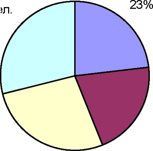
Cities with a population >700 thousand people 21%
100-700
Cities with population
Cities with a population of thousand people
27%
.
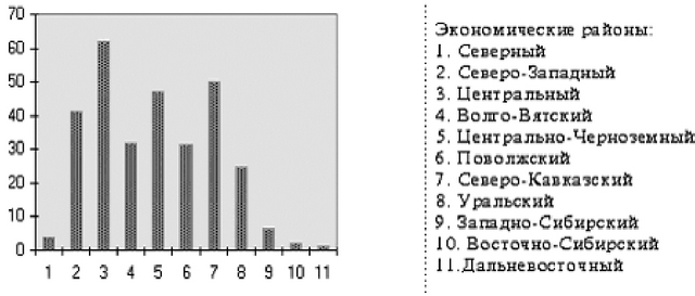
When considering the population density in the economic regions of Russia, a certain pattern is revealed - in the largest regions in terms of area, the lowest population density. Thus, the highest density is in the Central Economic Region (61.9 people/km2), whose area is 483.0 km2, while in the Northern Region with a population density of 4.0 people/km2, the area is 1466.3 people/km2, in West Siberian (density 6.2 people/km2) - area 2427.2 people/km2, in East Siberian (2.2 people/km2) - area 4122.8 people/km2 and in Far East (1.2 person/km2) - area 6215.9 person/km2.
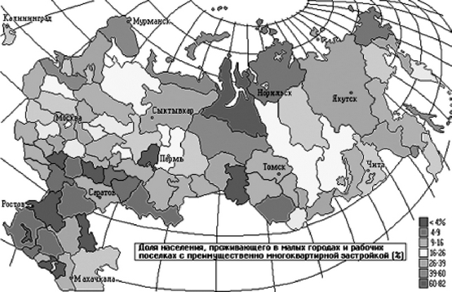
The structure of the population of Russia by types of settlements is shown in fig. 15.
The chart shows that more than half of the population lives in rural areas and in small towns and urban-type settlements (left side of the chart). The root form of settlements in Russia is the village - from 5 to 5000 or more households with vegetable gardens and adjacent fields for the cultivation of grain and potatoes. The maximum share of the population in rural settlements is concentrated in the Russian Chernozem region (slightly less in the Non-Chernozem region), in the Caucasus and in the agrarian regions of the south Western Siberia. Characteristically, regions with a high proportion of rural populations tend to be more resilient. social system and better indicators of public health. Consolidation into the category of urban population of residents major cities, including megacities, urban-type settlements and cities with developed suburban settlements, is conditional. The social and living conditions and lifestyle of the population in these categories of settlements differ significantly.
One should also take into account the "posada" population of larger cities, which, unfortunately, is difficult to calculate from standard statistics. In most cities with a population of 100 - 200 thousand inhabitants in the central and southern regions country's share of the settlement drops to 50%, and in some places more residents. From this it is quite clear that the total weight of the population living in the habitat and living conditions of the large cities proper in Russia is in fact hardly more than one third.
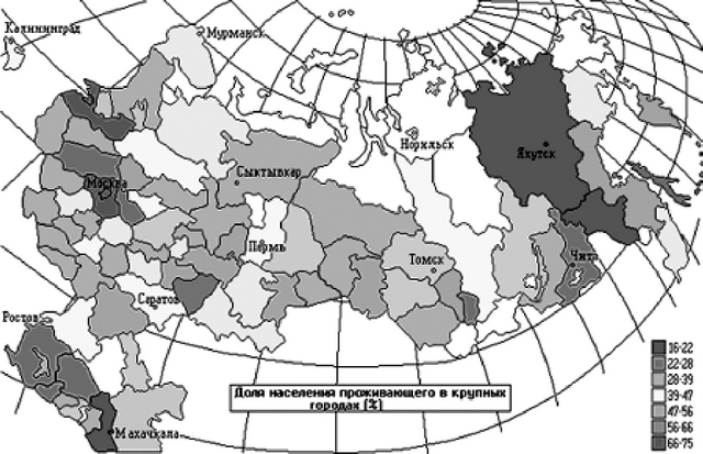
Cities with a population of over 1 million people in Russia, in addition to the "three capitals" - Moscow, St. Petersburg and Nizhny Novgorod- distributed, on the one hand, in the Azov-Ural region from Voronezh and Rostov-on-Don to Yekaterinburg, where each capital of the region is a "millionaire" city, on the other hand, in the south of Siberia - Omsk, Novosibirsk and Krasnoyarsk. The minimum part of the population lives in large cities in the North (there are usually no large cities here), in the zone of the predominance of the rural population (the Black Earth and the Caucasus). The urban population in most of the country is 60% or more of the region's population. Less than 45% falls on the urban population in the least developed autonomies of Siberia, the Far East and the eastern part of the Caucasus. An intermediate position (45 - 60%) in this indicator is occupied by a number of poorly developed autonomies, as well as the most agrarian regions of Russia (Altai, Krasnodar and Stavropol Territory, Tambov and Kurgan region). It is these regions (except for the Siberian autonomies) that are characterized by a highly developed settlement of cities (described in detail in a special section), therefore
it can be said that the bulk of the population here still lives in almost rural habitats and living conditions. In the most industrialized regions (especially in the Center, in the Urals, in Western Siberia), as well as in the youngest of the regions of Russia - the Far East, where development was already taking place against the backdrop of industrialization, the share of the urban population exceeds 75%.
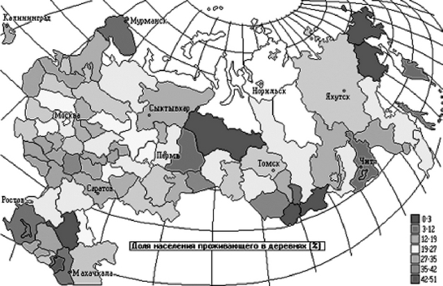
The picture of the distribution of the non-possad population in cities and towns with less than 100,000 inhabitants is quite definite. Such settlements play the most important role in areas of intensive development, as well as around the main regional centers. Apparently, in the first case, the creation of a large number of urban-type settlements and small towns around newly created industrial facilities (mines, factories, etc.) has an effect. Around major centers small towns and urban-type settlements most likely play the role of transshipment bases for the population striving from the village to big cities. Here they receive urban professions, from here they look for connections in the centers. It is characteristic that in the pastoral regions of southern Russia (Kalmykia, Khakassia, Tuva and some others), the population of small towns and villages almost always lives in apartment buildings without household plots.


