Which lake used to be called Khvalynskoye. A Brief History of the Caspian Basin
"The sea is the great reconciliator"
F. Iskander.
South of the city of Uralsk, the Ural enters the Caspian lowland, which is a deep tectonic depression with sharp manifestations of salt-dome tectonics.
The lowland goes down towards the Caspian Sea and has absolute marks from 50 meters at the foot of the Predsyrtovy ledge to -28 meters on the sea coast. Surface Caspian lowland It is composed of marine and continental clays and sands, less often pebbles and loams.
The geological territory of the Caspian lowland is very young. During the Quaternary period, it was repeatedly flooded as a result of transgressions of the Caspian Sea.
The largest offensive of the sea occurred about 20 thousand years ago. years ago at the beginning of the late Pleistocene, between the ice ages on the Russian Plain. As the ice sheet melted, the level of the oceans rose.
At the same time, the outskirts of the Russian Plain experienced subsidence. The Caspian, or Khvalynsk, Sea penetrated far to the north, flooding the entire Caspian lowland. Sea waters entered along the Volga above the place of its confluence with the Kama, and along the Ural valley they rose to the mouths of the Utva, Irtek and Kindel.
The coastline of the ancient Khvalyn Sea has been preserved in the form of a ledge not only in the river valleys, but also in the interfluves. It is clearly traced along the northern side of the Caspian lowland between the Volga and the Urals, as well as between the Urals and the Emba.
This ledge is clearly visible on relief maps approximately horizontally 50 meters above the level of the World Ocean. By the beginning of the last, Valdai, glaciation, the Khvalyn Sea left the Northern Caspian.
And it left quickly, leaving behind a 40-meter ledge. As a result of this, a mass extinction of marine animals occurred, as evidenced now by the accumulation of shells of marine mollusks in the upper sandy loam horizon of the Khvalyn deposits.
It has been established that it was during this period that the forest vegetation on the southern slope of the General Syrt (which at that time was the northern coast of the Caspian Sea) was replaced by steppe vegetation. Consequently, one of the reasons for the retreat of the sea was its drying up in a drier climate.
As a recent seabed, the Caspian lowland has a very flat surface. The monotony of its relief is broken by numerous drainless depressions of various outlines of unequal size.
The river network is almost not developed. Only a few large rivers and a number of dry hollows, originating in the Common Syrt and Cis-Ural Plateau, go to the lowland and deposit here all the loamy and sandy material carried down from the uplands, forming internal deltas.
The Caspian Sea is bordered by a wide strip of saline sands, crossed by wide sea channels, filled with water in the wind from the sea. The geomorphological landmark of the Caspian Sea are the so-called Baer mounds.
These are low (6 - 20 m) and long (from several hundred meters to 5 - 6 km) sandy ridges, mainly in the latitudinal direction. Near the sea, inter-hill depressions are occupied by bays (ilmens), and further from the coast - by salt lakes and solonchaks.
They were first described in the middle of the last century by Academician Karl Baer. The origin of Baer's hillocks is explained in different ways. Some scientists consider them to be erosional formations that have arisen in river deltas as a result of erosion of their surface by the waters of delta channels.
Others are longitudinal eolian ridges oriented along the prevailing winds, others are the remains of coastal ridges of the retreating Khvalynsk Sea. The well-known Soviet geographer F. N. Milkov connects their formation with the accumulation and movement of material by the waters of the ancient sea basins that retreated to the south, which were subsequently reworked by the wind.
There is also a hypothesis that considers the Baer knolls as sandy hills flooded by the waters of the ancient Caspian transgressions. On the territory of the Caspian lowland, there are small uplands (Inderskaya, Shalkarskaya, Koikarinskaya, Imankarinskaya), which are salt dome uplifts with outcrops of Permian, Jurassic, Cretaceous and Paleogene deposits.
The absolute heights of these hills range from 50 to 150 meters. In total, there are about 1,700 salt domes of various sizes in the Northern Caspian region. The climate of the Caspian lowland is dry, continental, with relatively severe and little snowy winters.
The average temperature in January is from -14° C in the north to -8° C, on the coast of the Caspian Sea. Summer is hot and dry. average temperature July is 22 - 24 ° C. Annual precipitation decreases from 300 mm in the north to 160 mm in the south.
The Ural in the section from Uralsk to the village of Krugloozernoye passes through the steppe, then from Krugloozernoye to Kalmykovo through the semi-desert, and below Kalmykovo through the desert. The light chestnut soils of the Caspian semi-desert are alkaline, often turning into real solonetzes and solonchaks.
Wormwood-fescue-feather grass herbage is sparse, often giving way to saltwort thickets. In the north of the Caspian Sea, soil desalinization processes are observed, which contributes to the gradual onset of steppe landscapes.
On the coast of the Caspian Sea, a sea terrace up to 50 km wide, recently freed from sea waters, is developed. In the sediments and on the surface of this terrace, the modern mollusk fauna of the Caspian Sea is found.
The sea terrace is characterized by a flat relief and is divided into three levels. Coastal strip, periodically drying up and flooding again sea waters, is occupied by reed beds and plump salt marshes.
During periods of sea retreat, thick seedlings of tamarix appear in this strip, usually dying when flooded. In the middle zone of the terrace, solonchaks are common, separated by narrow strips of low-growing reed and ground reed grass along depressions.
The upper level of the terraces is occupied by crusty-puffy solonchaks with sarsazan. The salty groundwater horizon is located here at a depth of 3–5 m. Thus, when moving from north to south along the Caspian lowland, one can trace a regular change former day Khvalynsky and the modern Caspian Sea.
In landscape and ecological terms, the Northern Caspian is very interesting as a place of mutual penetration of northern and southern elements. An amazing combination of northern and southern elements of the landscape, like an interweaving of the features of the nature of the Russian Plain, Ural mountains, Kazakhstan and Western Siberia very characteristic of the Ural basin as a whole.
This is explained by the fact that the Urals is a kind of crossroads of borders of very different ranks: between landscape zones, mountainous and flat physiographic countries and parts of the world.
The river network of the Ural-Emba basin, like blue threads, stitches the patches of these diverse landscapes into a single motley carpet.
In the previous material, we in general terms found out what happened to the Tethys ocean (read about those events the material The Tethys Sea and its fate). The story didn't end there. The Mediterranean Sea and Paratethys became the descendants of Tethys - in the future it will turn into the Black and Caspian Sea. This story is about how today's Caspian Sea appeared. I must say, sometimes the Aral Sea is called among the relics of Tethys, but this sea simply appeared above the place where the Paratethys bays disappeared long before, and the Aral basin is not its direct descendant.
Let's continue the description of events from the Upper Miocene (the Miocene is the epoch of that geological period called the Neogene, the Miocene lasted from 23 to 5.2 million years ago). In this period of time, in the so-called Sarmatian age, 14.0 - 10.5 million years ago, an almost closed Sarmatian lake-sea is formed (Fig. 1), which had a difficult connection with the south mediterranean sea. In this lake-sea, a peculiar brackish-water fauna of mollusks develops, consisting mainly of a few genera and species of lamellar-gill and gastropods, the most common of which were various species of the genera Cardium, Mactra, Tapes, Trochus, Buccinum, Cerithium. Basically, according to the fauna of mollusks, in fact, the history of the Sarmatian Sea (however, like other ancient seas) was restored. By the end of the Sarmatian century, due to the progressive desalination of the Sarmatian basin, the fauna of its mollusks became even more impoverished and reduced to several species of the same genus Mactra, found in large numbers. The desalination of the basin is associated with the mass of fresh water, which was brought by the rivers flowing into the basin, as well as for the modern Caspian Sea. In addition to mollusks, fish also lived in that sea (and in subsequent ones). Types and appearance their was similar to modern inhabitants of semi-enclosed seas.
Fig.1. Sarmatian Sea. Maximum dimensions.
The Sarmatian was followed by the Meotic. In the Meotic Age (Fig. 2), 10.5–7.0 million years ago, the desalinated pool temporarily reconnects with open sea; its waters acquire greater salinity, and some marine stenohaline (that is, with a narrow salt range of habitat) species of mollusks again penetrate into it. This connection, however, is quickly interrupted. Late Miocene–early Pliocene (Pliocene–second Neogene epoch, 5.2–1.8 million years ago) the next, Pontic age comes to replace the Meotis. Its time limits are something like 6.5– 5.2 million years. This Pontic basin, greatly reduced in size, is again desalinated and populated by a monotonous poor brackish-water fauna (Fig. 3).
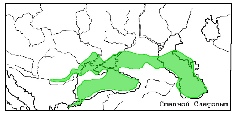
Fig.2. Maeotic Sea. Maximum dimensions.
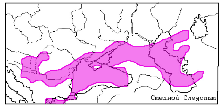
Fig.3. Pontic lake-sea just before the breakup.
Subsequently, due to the continuing uneven uplift of the northern marginal strip of the geosynclinal region (in this region, due to the collision of Africa and Europe, the Alps and Caucasian mountains) and the adjoining marginal zone of the Russian Plate, the considered basin breaks up into a number of small isolated water bodies, the subsequent history of which was very different.
The collapse of the Pontic Basin occurred near the time boundary at 6.5 million years ago. Among the reasons for the collapse is called the uplifting of the Caucasus. In addition, there is another substantiated version of the reasons for the collapse. At this time, the Mediterranean Sea is experiencing a messianic crisis, that is, it completely dries up due to the closure Strait of Gibraltar(Mediterranean water evaporated, and nothing came from the ocean to replace it). It is very likely that at some point the Pontic Sea broke through the region of the Bosphorus and the Dardanelles into the dried basin of the Mediterranean. This outflow of water caused, of course, a decrease in the level of the sea, as a result of which it was divided into separate water bodies.
One of these reservoirs, isolated at the end of the Sarmatian time (Pannonian), occupied the region of the Hungarian (Pannonian) lowland; gradually decreasing in size and becoming more and more desalinated, by the end of the Neogene period (about 2 million years ago) it was almost completely dried up. Its last remnant is Lake Balaton in Hungary.
The second basin, formed during the collapse of the Pontic Lake-Sea - the Black Sea, or Evksinsky - occupied the basin of the modern Black Sea. By the end of the Late Pontus, about 5.2 million years ago, it shrank in size. The Northern Black Sea region and the shelf of the Azov-Black Sea basin dried up. Soon, when the Mediterranean Sea restored its depths (Gibraltar opened), water burst into the Black Sea from it, forming the so-called Cimmerian Sea (5.0 - 3.4 million years ago).
The history of the development of the third large basin that arose on the site of the Pontic Lake-Sea - the Caspian Sea - turned out to be the most interesting and complex. By the middle of the Pliocene (Balakhani Age), it greatly reduced in size (Fig. 4). The area of this Balakhani lake, which filled only the depression of the southern Caspian, exceeded the area, for example, of modern Ladoga by 6-7 times. The Balakhani reservoir had a peculiar salinity regime. The presence of ostracod fauna testifies to its freshwater nature. And the layers of gypsum, anhydrite, celestite minerals, on the contrary, indicate its supersalinity. Apparently, the basin was indeed supersaline, and freshwater fauna lived in estuaries and lagoons into which the rivers flowed. The reservoir itself consisted of a system of semi-isolated pools.
The rivers flowing into that Caspian (in particular, the paleo-Volga) cut deep and narrow gorges several hundred meters deep into the thickness of the rocks. The delta deposits of the Paleo-Volga formed an oil-bearing "productive" stratum up to 4000 meters thick in Lake Balakhani.

Fig.4 Ponto-Caspian region in the middle of the Pliocene (Balakhani age). The Caspian remained in the form of Lake Balakhani.
Later (Akchagyl age, 3.3–1.85 million years ago) the size of this sea, already the so-called Akchagyl, increases greatly (Fig. 5), especially in the north, and it receives a message along the lowlands of Ciscaucasia with the Black Sea sea basin. The reason for this happening 3.5– 3.4 million years ago, the unification of the Euxine and the Caspian was a general rise in the level of the World Ocean. Thanks to the association, some stenohaline species of mollusks penetrate into the Akchagyl Sea, indicating a relatively high salinity of the waters.
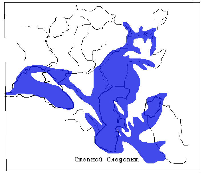
Fig.5. Kuyalnitsky (belongs to the Black Sea) and Akchagyl basins. The maximum sizes of reservoirs are shown.
The end of the Akchagyl age corresponds to the end of the Pliocene epoch. After a short regression at the beginning of the next, Quaternary period, the Caspian is almost restored in the form of a new sea, the Absheron Sea.
This sea rises to today's Kamyshin on the Volga, to Uralsk along the Ural River (Fig. 6). Its waters flood the plain Ciscaucasia, connecting with the Black Sea over the future Manych, and merge with the Aral reservoir. The Absheron Sea exists from 1.7 to 1 million years ago. When retreating Apsheron Sea on its northern coast, forests of the southern taiga type grew. Apsheron time corresponds to the first section of the Quaternary period, called the Eopleistocene.
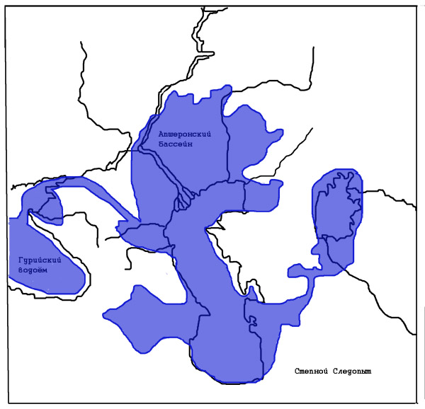
Fig.6 Ponto-Caspian region in the Apsheron age (maximum dimensions of the Apsheron basin)
And further in the Quaternary period, in its second part - the Pleistocene (or Neopleistocene; then the Pleistocene means the Quaternary period as a whole), the closed Caspian basin experienced sharp fluctuations in its level. There is a threefold expansion of the limits of the Caspian Sea (against the background of these large, or great, transgressions, fluctuations of a smaller hierarchy took place). These transgressions of the Caspian Sea (Baku, Khazar and Khvalyn), the last of which was the largest in terms of area (Fig. 7), and the regression phases between them are associated with sharp changes climatic conditions on the Russian Plain - by the alternation of glacial and interglacial epochs, when the circulation regime of the atmosphere and the flow of the Volga changed.
At present, it is believed that, for all the complexity, in general terms, the transgressions of the Caspian Sea in the Pleistocene coincide with cooling and glaciation in the central and northern regions Russian Plain, and regressions - with warmings in interglacials. Apparently, this pattern is explained by a decrease in evaporation from the surface of the Caspian Sea in cold, glacial periods and vice versa, an increase in evaporation during warm times of interglacials.
While the World Ocean rather clearly lowered (by a value of about a hundred meters) during periods of glaciation (a huge amount of water was bound in ice sheets), the features of the actually closed, despite the existence of the Manych Strait sometimes, the Caspian and the Black Sea, which lost contact with the World Ocean, significantly complicate the behavior of the level of these seas ... Back in the middle of the 19th century, the great scientist Carl Baer (or, more precisely, Carl Maximillian von Baer) wrote: an opportunity to express both my scientific strengths and all my love for science.
In the interval of 600-500 - 400-350 thousand years ago, during the Baku transgression, the sea level reaches absolute marks of 40-50 meters, again reaching Kamyshin and Uralsk. Through the Manych, the Baku basin was connected to the Black Sea. Pine-spruce forests grew in the Northern Caspian at that time, and steppes existed in the east. During the subsequent Oka glaciation, the sea level fell by 30-50 meters below the modern one - this was the Venedian regression.
In the middle Pleistocene, in the interval somewhere between 300-200 thousand years ago, on the site of the Caspian Sea, there was an early Khazar sea, slightly inferior in size to the Baku one. The sea level gradually decreased during this epoch. The north of the Caspian Sea was surrounded by cool steppes.
In the interval 120-80 thousand years ago there was a late Khazar transgression, with a slight increase in the level.
20-12 thousand years ago, the most significant transgression occurs - the Early Khvalynian, with a rise in the water level at least 70 meters above the modern one ( a number of scientists believe that the early Khvalynian transgression took place 70– 50 thousand years ago). On the northern coast of the Khvalyn Sea, there were dry cool steppes with haze-wormwood plant groups, with a significant number of plants in wet solonchaks and solonetzes.
Later, about 7-9 thousand years ago (perhaps 20- 10 thousand years ago, according to another opinion), a much smaller Late Khvalynian transgression took place - already without the formation of the Manych Strait. It was replaced by the Mangyshlak regression followed by the New Caspian transgression (up to -20 meters absolute altitude, 6-4 thousand years ago).
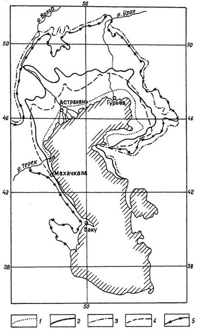
Fig.7 The boundaries of the distribution of marine transgressions in the Caspian depression: 1 - New Caspian; 2 - late Khvalynian; 3 - early Khvalynsky (maximum); 4 - late Khazar; 5 - early Khazar
In the flat Northern Caspian, the line of the sea coast fluctuated, now advancing on low land, then retreating. And along Caucasian coast, figuratively speaking, moved relative to the water of the mountain. The mountains of the Caucasus in the Quaternary period grew intensively upwards, therefore, south of Makhachkala, there is a range of marine terraces (abrasive-accumulative, that is, waves knocked out a terrace ledge in the shore and deposited a small amount of precipitation on it), the number of which reaches 15. The highest Pleistocene terraces located at an altitude of up to 400 meters.
So for a dozen and a half million years from the Gulf of the Mediterranean - the Sarmatian Sea, passing successively the stages of the subsequent Meotic, Pontic, Balakhani, Akchagyl, Apsheron, Baku, Khazar, Khvalyn, with many intermediate stages, the Caspian Sea turned into today's unique reservoir with its unique and diverse nature. Its shores saw outlandish animals, steppes, forests, taiga and subtropics.
The history of the Caspian continues.
Steppe Pathfinder
References:
"Historical Geology", G.P. Leonov. Moscow, 1956
Radiometric scale for the Late Cenozoic of the Paratethys. I.S. Chumakov. Nature. 1993 No. 12.
Global climatic events of the Neogene. V.A. Zubakov. 1990
The future of the Caspian is in its past. A.A. Svitoch, T.A. Yanina. Nature. 1996 No. 2.
Stratigraphy and correlation of Sarmatian and Maeotic deposits in the south of the USSR, ed. L.A. Nevesskoy, Saratov. 1986
The reason for this work was publications about the discovery of the Global Flood in the Black Sea, primarily books and articles by Bill Ryan, Walter Pittman (1997), Petko Dimitrov (2003) and Dr. Ballard.
Geology of the Flood.
Geological evidence of the Flood can be considered bottom and coastal sediments of flood basins, as well as paleontological remains in them. Their detailed analysis, including lithological, mineralogical, geochemical indicators, as well as the isotopic composition of sediments and fossil remains, makes it possible to reconstruct the conditions of sedimentation, the composition of flood waters, and the sequence of flood events.
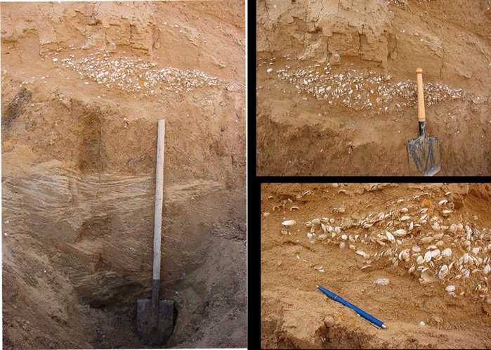
At the epicenter of the Flood Caspian Basin - bottom sediments are represented by sediments of the Khvalynsk (more precisely, the Early Khvalynsk for the Flood maximum) basin. They differ from the overlying and underlying sediments in many ways. The most characteristic are the so-called. "chocolate clay" , named for their distinctive reddish-brown color. In some places they are interbedded with greenish-gray and dark-gray clays, forming a thin (1-2 cm) ribbon bedding. Chocolate clays also interbed and facies change into silts, sandy loams, rarely sands with a high content of clay matter and shells of Caspian-type marine mollusks. The thickness of chocolate clays and associated Khvalynian sediments usually does not exceed a few meters. (3-5 m), sometimes reaches 20-25 m and more. The main area of these deposits is The Caspian lowland from the modern coast of the Caspian Sea to the foothills of the surrounding uplands (Ergeni, General Syrt, Volga, Stavropol), as well as in the estuaries of the Volga and the Urals. The area of the Khvalynsk deposits, exposed directly to the day surface, reaches here 0.5 million km 2., A total area development of Khvalynsk sediments - up to 1 million km 2.
The characteristic reddish-brown color of chocolate clays is not associated with free iron oxides, but with clay minerals, including iron oxides. Fe. The low content or absence of carbonates in clays indicates a cold climate, because at low temperatures, the solubility of carbonates increases, and they are retained in solution. On the other hand, the abundance of chemogenic pulverized carbonate and the absence of secondary alterations in terrigenous pelitomorphic clay matter indicate that sedimentation proceeded in a dry climate. The beginning and peak of this transgression falls on arid environments with increased evaporation processes. The geochemistry of sediments and the composition of authigenic minerals allow us to conclude that the Khvalyn transgression was formed not under humid conditions, but under rather arid conditions. (Chistyakova, 2001).
In the series of marine layers of the Caspian Basin, the Khvalyn deposits occur above the Late Khazarian (Last Interglacial) and below the New Caspian (Holocene) sediments. They are separated from the Lower Khazar by the continental freshwater atel layers, synchronous in deep sea basin sediments of the Atel regressive basin, the level of which was 110-120 m lower than the current level of the Caspian, i.e. at around -140 -150 m abs. (Lokhin, Maev, 1986; Chepalyga, 2002).
In the Manych depression analogues of chocolate clays are clayey-silty reddish-brown color - Abeskun layers G.I. Popova(1980) - lie on the surface of the depression and are not covered by anything, but contain a fauna of Caspian-type mollusks with Didacna Monodacna, Adacna, Hipanis, Dreissena, Micromelania. They compose the accumulative swells of the Manych Strait and correspond only to the early Khvalyn deposits of the Caspian Sea and the main episode of the flood events of 16-14 thousand years ago.
In the Black Sea basin the Flood deposits lie within the neo-Euxinian deposits (karkinite layers). On the continental slope and in the deep-water basin, they are represented by peculiar light reddish-brown and pale-yellow silts up to 0.5-1.0 m thick. Their color resembles the chocolate clays of the Caspian basin, their age is also close (15 thousand years).
Paleontology of the Flood.
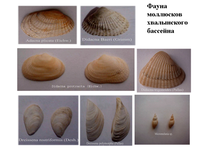
The main indicator of the marine Flood are specific brackish-water molluscs. , represented by species close to modern North Caspian. Among them, Caspian endemics from the family Limnocardiidae: genus Didacna Eichwald, now not living anywhere outside the Caspian Sea, but widely represented in the Pleistocene of the Azov-Black Sea basin up to and including the Karangat basin. Didacni presented Didacna praetrigonoides(dominant), D. parallella, D. delenda, D. supcatillus, D. ebersini, D. pallasi, as well as relatively deep (>25 m) D. ( Protodidacna) protracta. Of the other endemic limnocardiids, here are characteristic Monodacna caspia, M. laeviscula, Adacna vitrea, Hypnanis pklicata. The most widespread elements outside the Caspian early Khvalynian fauna are Dreissena subgenus ( Pontodreissena (D. rostriformis), and in desalinated areas D.polymorpha. From gastropods, representatives of the Caspian endemic genera are often found. Caspia And micromelania. The shells of the early Khvalynian complex are distinguished by their small size (2–3 times smaller than modern ones) and thin-walled shells. These deposits are usually associated with cold climates and low salinity. However, in cold conditions, larger individuals usually develop (Cope's law), and the conclusion about low salinity is untenable, because. rich species composition indicates salinity close to the North Caspian - up to 10‰ and more. A more realistic explanation is the significant turbidity of the water and the lack of oxygen at the bottom of the pool. The cause of increased turbidity could be solifluction processes accompanying the thawing of permafrost..
Neo-Euxinian deposits contain fauna of mollusks of the Caspian type; and mussels dominate here Dreissena rostriformis, less often Dr. polymorpha and limnocardiids Monodacna Caspia, M. colorata, Adacna, Hipanis and gastropods Caspia, Micromelania.
In the Black Sea completely absent didacnae of the genus Didacna, they are tracked along the Manych valley up to the lower reaches of the river. Zap. Manych (With. Manych-Balabinka) . This may be an indicator of lower salinity (up to 5-6‰) in the Novo-Evkvinsky basin.
A fauna of the Caspian type, similar in composition, was discovered by us ( Algan and oth., 2001, 2003) in bottom sediments of the Bosphorus in well 14 at the marks 80-100 m with dating 16-10 ka. Its composition is dominated by the Caspian Dreissena rostriformis.
In the sediments of the Early Khvalyn Sea microfauna is also found: foraminifera, ostracods, and diatoms.
Geomorphology of the Flood.
The waters of the Flood left clear traces of their dynamics in the relief morphology: sea terraces, specific coastlines, leveled flat bottom topography, as well as erosional-accumulative landforms of flood water discharge channels: Manych-Kerch Strait, Bosporus and Dardanelles .
Valleys of the discharge of flood waters. Manych-Kerch Strait - this is a giant erosional runoff trough that connected the Caspian with the Black Sea basin. The total length of the strait reached 950-1000 km and varied with sea level; maximum width 50-55 km, minimum - 10 km. Depth - up to 30-50 m. The slope of the strait bottom was 0,0001 , and the water level difference from the Caspian Sea ( +50 m abs.) to the Black Sea ( -80 -100 m) reached 150 m at the beginning of the drain and 100 m at the end of the drain. Water consumption has reached 50 thousand km 3
Coastline. Early Khvalynsk basin fundamentally different from the modern one, because at a higher sea level, it rested against the foothills of the hills surrounding Caspian depression (Ergeni, General Syrt , Volga) . Instead of accumulative shores whimsically indented by shallow bays on the flat surface of the Caspian lowland and large deltas of the Volga and Urals, abrasion shores with deep bays - fiord-type estuaries appeared. An example is the bay we studied along the river valley Yashkul , penetrating deep into the Ergeni on 50 km and filled with a thickness of chocolate clay with Khvalyn marine fauna.

Marine terraces fix the position of sea level and coastline on every oscillation recession phase of the Khvalyn Sea . Due to the unusually high rise in the level of the Flood Basin, its deposits overlap much older terraces and form up to 9 marine terraces with the following levels in tectonically stable areas (Dagestan): 48, +35, +22, +16, +6, -5, 0, -6, -12 m ( Rychagov 2001, ....; Switch 2000, ....). These terraces record the standing of the levels at the phase of the general recession of the basin, and these oscillations were interrupted by a significant decrease in the level by tens of meters. The most significant of these are 2 regressions: Eltonskaya (up to -50 m abs.) And Enotaevskaya (up to -100 m abs.). These data allow us to reconstruct
Fluctuations in the level of the Khvalynsk basin in the phase of decline.
Flood timeline.
The time frame of the Biblical Flood, according to various sources, varies from 4.5 to more than 10 thousand years. So, the flood in Mesopotamia is determined in the interval of 4500-6000 years ( Rowe, 2003), however, this Flood was not worldwide, but rather a description of a major flood. Concerning Biblical flood, then by latest research, based on different sources, dating about t XII to IX millennium BC. uh. (Balandin, 2003), those. from more than 13 to 12 thousand years ago. So the age of the Flood is coming to an end ice age, and not in the very end. The duration of the Flood also varies from two weeks to several months. In theological literature, there is even an exact date for the Flood - 9545 BC. uh. (Leonov et al., 2002),those. 11949 years ago. Pretty close dates of the Flood events were obtained based on the study of its deposits: the Khvalyn deposits of the Caspian Sea, the New Euxinian deposits of the Black Sea, as well as alluvial deposits that fill macrobends in river valleys.
The chronology of the Khvalyn transgression of the Caspian Sea, for which there are more than fifty radiocarbon datings, has been studied in particular detail. (Rychagov, 1997; Svitoch 2002; Leonov et al., 2003). Most of dating fits in the interval of 16-10 thousand years.
Total during Khvalyn time (5-6 thousand years) there are up to 10 cycles of level fluctuations with a frequency of 500-600 years. They are united in 3 groups with a duration of 2 thousand years. Fluctuations in the level of the Khvalynsk basin, as well as displacement of the coastline for hundreds and thousands of kilometers, as well as large-scale flooding and drainage of sea basins, can be considered as waves of the Flood stretching for 5-6 thousand years. First wave of the Flood early Khvalynian , began 14-15 thousand years ago and lasted about 2 thousand years; it was complicated by three oscillations with sea levels +40, +50, +35 m abs. Because runoff threshold in Manych Strait at that time was at a level of only +20 m, then all these three pools overflowed into The Black Sea through the Manychko-Kerch Strait. It is this first wave, and especially its ascending phase, that can be considered as World Flood in Ponto-Caspian. Second Wave of the Flood, Middle Khvalynian, at the peaks of oscillations no longer exceeded +22, +16 and +6 m and the Caspian waters did not overflow into the Black Sea, the strait probably did not function. The third wave of the Flood, the late Khvalynian, no longer rose above the current level of the ocean, and all its 4 oscillations (-5, 0, -5, -12 abs.) were below it, but above Holocene level of the Caspian.
Hydrology of the Flood.
Marine pools .
The most significant in scale and most suitable for comparison with the ancient mythical floods unfolded in the inland sea and lake-sea basins of Eurasia, known as Ponto Caspian.
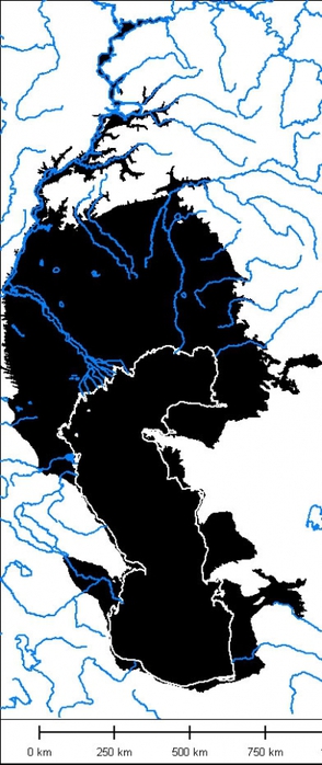
Khvalynsk Sea. The epicenter of the Flood and the most sensitive indicator of its events (rising sea levels, moving coastlines and flooding of coastal areas) was Khvalynsky basin of the Caspian Sea , especially at the peak of the transgression. It was in it that the main mass of the Flood waters was concentrated, their composition and habitat were transformed, and the excess waters merged into the Black Sea. As a result of the development of the Flood The Khvalynsk Sea spilled over an area of about a million square meters. km, and together with the Aral-Sarykamysh basin, its water area exceeded 1.1 million km 2, which is 3 times larger than the modern Caspian. The volume of accumulated water masses (130 thousand km 3) exceeded the modern one by 2 times. As for the events of the Flood itself, almost a million km2 of low-lying territories were flooded up to +48 +50 m abs. g.o. in the Caspian plain. The type of the pool has also changed: isolated drainless lake (Athel pool) as a result of the Flood, it turned into a giant flowing lake-sea with a one-sided discharge of water into the neighboring pool. Despite the repeated flushing of the pool fresh water, the chemical composition and mineralization of waters have changed little (within 10-12‰), because the main ecological indicator - the composition of the fauna of mollusks and other organisms has not changed significantly. Perhaps this indicates the short duration of the existence of the flow basin. But still water Khvalyn Sea different from the Caspian low temperature (4° C in the north and up to 14° C in the south), which is confirmed by the isotopic composition of oxygen (18O = 10‰). One can also assume the high turbidity of the Khvalynsk waters, which affected the composition of sediments and the small size of mollusk shells. This is due to the powerful influence of solifluction processes and an increase in solid runoff from river basins ( Leonov et al., 2002 ) .
Novoevksinskoe Sea . During the Flood, the Novoevksinskoe lake-sea was located in the Black Sea depression, the level of which was very low and at first did not exceed -80 -100 m. As a result of the discharge of flood waters from the Caspian, the level very quickly rose to -50 -40 m abs. The water area increased from 350 to 400 thousand km 2 , so the area of the shelf flooded by the waters of the Flood did not exceed 20-30 thousand km 2 . The volume of water masses in the Novoevksinsky basin reached 545 thousand km 3 (slightly less than the Black Sea), but these were waters of a completely different origin.
River floods were caused by a multiple increase in river flow, especially during grandiose spring floods - super floods. (super foods) in river valleys with flooding of all floodplains and low river terraces. These processes caused the formation of large river channels, much larger than the modern channels of the corresponding rivers. They are known as latitudinal valleys, macromeanders, large bends. (Dyry 1964, Panin, Sedarchuk 2005). River runoff passed through these paleochannels and served as the main source for marine flooding - transgressions of internal lake-sea basins.
Slope flooding covered almost all the slopes of the valleys and other relief elements and manifested itself especially actively in the spring-summer season during the intensive thawing of permafrost, increased solifluction flows down the slopes, their moistening, planar water runoff, accumulation of fine earth sediments on the bends of the slopes. Melting permafrost and slope flooding were additional sources water for the formation of river superfloods. These processes have been best studied in detailed studies at Paleolithic sites.
Interfluve floods covered vast areas plateaus and interfluves with a relatively flat relief. As a result of uneven thawing of permafrost, thermokarst processes have intensified and the area of thermokarst lakes - paleoalases - has increased significantly. Lakeing of interfluves has led to an increase in the spaces of water areas and a reduction in the area of territories.
Cascade of Eurasian Basins (Vorukash Sea) . As a result of the events of the Great Flood, a system of interconnected basins was formed in inner Eurasia. They are traced from Caspian Sea to Sea of Marmara , which makes it possible to reconstruct Eurasian Cascade pools, including Aral-Sarykamysh basin, Uzboy, Khvalynsk Sea, Manych-Kerch Strait, Novoevksinskoe Sea, Bosphorus, the ancient Sea of Marmara. Coming through Strait of the Dardanelles the waters of this Cascade merged to the mediterranean sea. In terms of the scale of the water area, the lake-marine system of the Eurasian cascade has no analogues. Of the modern inland basins, the largest lake system in the world is the Great Lakes. North America- are significantly inferior to the flood basin in all respects: in terms of area (245 thousand km 2) - 6 times, in terms of the volume of water masses (227 thousand km 3) - 30 times, in terms of discharge discharged under (14 thousand m 3 / sec) - more than 4 times, in terms of the catchment area - more than 3 times.
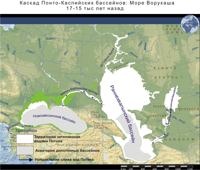
Cascade of the Eurasian basins made an impression on ancient man and could be reflected in the ancient epic and mythology. In particular, a description of a similar basin is given in "Avesta" — sea of Vorukash .
Sources of water for the flood:
superfloods in river valleys
melting permafrost
higher runoff coefficient due to permafrost
increase in catchment area due to Central Asia
reduction of evaporation from the water area due to the ice regime.
Reconstruction of the Flood
Biblical version of the flood.
Consider first the biblical version of the hydrological events of the Flood. The beginning of the flood is described as follows:
“... all the fountains of the great abyss burst open and the windows of heaven were opened; and it rained on the earth for forty days and forty nights.” (Genesis 7:11-12).
Further development of events led to the emergence of extreme hydrological events:
“And the flood continued on the Earth for forty days (and forty nights), and the water multiplied, and it (the ark) rose above the earth; and the waters increased greatly and greatly increased on the earth, and the ark floated on the surface of the waters.” . (Genesis 7.11)
“And the waters increased exceedingly on the earth, so that all high mountains which are under heaven; fifteen cubits the water rose on them… And every flesh that moved on the earth lost its life… And the water increased on the earth for a hundred and fifty days.”. (Genesis 7, 11-21).
It was the peak of the flood events, the maximum rise in the level. After that, the flood subsided:
“... and God sent a wind on the earth and the water stopped. And the fountains of the deep and the windows of heaven were closed, and the rain from heaven stopped. And the ark rested in the seventh month, on the seventeenth day of the month, on the mountains of Ararat. The water constantly decreased until the tenth month, on the first day of the tenth month the tops of the mountains (Ararat) appeared.( Genesis 7, 8).
The completion of the flood events is described as follows:
“The six hundred and first year (of Noah's life), by the first (day) of the first month, the water on the earth dried up; And Noah opened the door of the ark and looked, and behold, the surface of the earth dried up. And in the second month, on the twenty-seventh day of the month, the earth dried up.” . (Genesis 8.14).
Chronology and localization of the biblical flood.
Flood age. The time of the flood events is determined in the biblical calendar from the birth of Noah, similar to the modern calendar with a countdown from the birth of Christ.
"Noah was six hundred years old when the flood of water came upon the earth" (Genesis 7, 6).
This date looks like: 600 RN (nativity of Noah). True, this date is not tied to other known dates, including the present. But theologians have long calculated the date of the flood, using data on the birth, death and life expectancy of subsequent generations of numerous descendants of Noah. (Genesis 10-11).
The time frame of the Biblical Flood, according to various sources, varies from 4.5 to more than 10 thousand years. So, flood in Mesopotamia defined in the interval 4500-6000 years (Row, 2003), however this Flood was not worldwide, but rather a description of a major flood. As for the Biblical flood, according to the latest research based on various sources, dating from the 12th to the 9th millennium BC predominates. e. (Balandin, 2003), those. from more than 13 to 12 thousand years ago. This means that the age of the Flood goes to the end of the ice age, and not to its very end. The duration of the Flood also varies from two weeks to several months. In theological literature, there is even an exact date for the Flood - 9545 BC. e. (Leonov et al., 2002), those. 11949 years ago. Fairly close dates for the events of the Flood are obtained from the study of its deposits: Khvalyn deposits of the Caspian Sea , Neo-Euxinian sediments of the Black Sea , as well as alluvial sediments filling macrobends in river valleys.
But this date is in good agreement with the radiocarbon dates of the Late Khvalynian transgression. (Arslanov et al. 2007, 2008).
Duration of Noah's voyage.
Until now, the prevailing opinion is that the flood and the journey of Noah lasted only 40 days. But this is a deeply erroneous notion: a careful reading of the Bible allows one to establish a significantly longer duration of these events.
For a more accurate determination of the duration of Noah's voyage, it is necessary to identify the date of the exodus, i.e. start and date of descent, i.e. its end and disembarkation from the ark. Both of these dates are indicated in the Book of Genesis quite accurately, however, in the system of counting time from the birth of Noah. But this does not prevent us from determining the time of the voyage with an accuracy of one day.
Exodus time, i.e. sailing, is defined by the following quotation:
“The waters of the flood came upon the earth. In the six hundredth year of Noah's life, in the second month, on the seventeenth day of the month" (Genesis 6, 11).
By analogy with modern calendar, it will look like this: 02/17/600. RN (from the birth of Noah). And further:
« On this very day Noah and Shem, Ham and Japheth, the sons of Noah, and the wife of Noah, and the three wives of his sons, entered the ark with them.” (Genesis 7, 13).
The time of the descent from the ark (near Mount Ararat) is given exactly in Chapter 8 of the Book of Genesis:
“The six hundred and first year (of the life of Noah), by the first [day] of the first month, the water on the earth dried up; And Noah opened the roof of the ark, and looked, and behold, the surface of the earth dried up. And in the second month, to the twenty-seventh day of the month, the earth dried up ... And Noah went out and his sons, and his wife, and his sons' wives with him ” . (Genesis 8, 13-14, 18).
IN modern form the date of descent looks like 02/27/601. RN. The difference in the dates of the exodus (17.02.600 RN and descent 27.02.601 RN) is one year and 10 days. This is the full duration of Noah's voyage from landing on the ark to landing on earth - a total of 375 days.
True, the net sailing time by sea may turn out to be somewhat less. It is necessary to subtract the time from boarding the ship (17.02.600 PH) to the ascent of the ark (up to 40 days) and after the opening of the roof of the ark on 01.01.601. PH until complete drying of the earth 27.02.601. pH, i.e. 57 days. Then the duration of Noah's voyage in the waters of the Khvalynsk basin will be from 278 to 318 days, those. about one year, on average 300 days.
Noah's sailing distance.
Now, knowing the duration of the voyage, we can approximately estimate the distance that Noah sailed on the ark during this time. It is logical that he sailed in one direction from north to south quite purposefully. At first, the swim was in the paleoestuary of the Volga , the ark slowly drifted downstream to the confluence with the sea and further - along the western shores of the Khvalyn Sea . Let's take a real average speed sailing about 5 km per day, also taking into account the inevitable stops for replenishment of supplies and weather conditions. Then the speed of movement could be about 200 m / h or 3.5 m / minute or 5-10 cm / second. During the voyage during the year, the ship could cover a distance of about 1500 km. This exceeds the length of the modern Caspian from north to south (1200 km). This seemed to contradict the biblical version. However, it should be taken into account that the Late Khvalynsk basin at that time had a higher level, above ±0 m abs. and a larger water area, its length from north to south reached 1400-1500 km, and if we take into account the Volga paleoestuary, then a little more - 1500-1600 km., Which approximately corresponds to the distance covered during Noah's voyage. This is a fairly good agreement between paleogeographic and biblical data.
Location of flood events in the EEZ.
Now it is possible to determine the place of action from biblical sources, i.e. the waters in which Noah sailed. To do this, you must first identify the type of sea basin, its size, and geographical position as mentioned in the original geographical objects. All this information can be obtained from the Bible, more precisely from Books of Genesis (Old Testament) in chapters 7, 8 and 9. the reconstruction of the watercraft - Noah's ark - will also be very useful for this purpose.
When determining the type of basin, we proceed from the fact that a rapid rise in the water level is impossible in a reservoir connected to the ocean, because the level of the ocean, due to its size and inertia, cannot rise so quickly. This means that it was an intracontinental closed body of water with no connection to the ocean. Now you can determine the geographical position of this reservoir using clues from the Bible itself. The Book of Genesis mentions that Noah sailed along the mountains of Ararat:
“And the ark rested in the seventh month, on the seventeenth day, on the mountains of Ararat” , (Genesis 7, 10)
Mentioned here "Mountains of Ararat" are directly related to the Caucasus . And not only to the Greater Caucasus , but also to the Lesser Caucasus , where is located Mount Ararat , as the place of the descent and end of Noah's journey. And the nearest large isolated reservoir is located just east of the mountains Caucasus in the Caspian Basin . If paleogeographical data are involved, then it is possible to reconstruct the flood basin of the time of Noah's voyage. this time (11-12 thousand years ago) existed here Khvalynsky basin , in the late phase of transgression, i.e. Late Khvalynsk Sea with high-stand levels from ±0 m abs. (Makhachkala phase) up to + 15 m abs. ( Turkmen phase ). Since the main parameters of the basins of these phases are already known to us, they can be used to reconstruct biblical events, including Noah's voyage.
Noah's Ark.

Of great importance for the reconstruction of the flood events and Noah's voyage is the restoration of the type and size of the watercraft on which Noah sailed - Noah's Ark. Its main dimensions are given in the Book of Genesis and can be used to interpret the parameters of the reservoir and flood events:
“Make yourself an ark and make it like this: the length of the Ark is 300 cubits, its width is 50 cubits, and its height is 30 cubits” .
Considering that the cubit in ancient times was about 0.5 meters, then in metric units it will be: length 150, width 25 and height 15 meters. In terms of size, this is a fairly large watercraft even for modern ships. Attention is drawn to the observance of the ideal proportions of width and length (1:6), adopted even now in shipbuilding. This means that the ark was intended for a long and distant voyage.
As for the material from which the ark was built, it is, of course, a wooden vessel, which is clearly stated in the Bible. And it is from the same type of wood:
"Make yourself an ark out of gopher wood..." (Genesis 6, 14).
gopher tree- this is most likely a coniferous tree, namely larch Larix sibirica, because it does not rot in water. In support of this, there is an indication that the ark was impregnated with resin for tightness:
“... make compartments in the Ark and cover it with pitch inside and out ...” . (Genesis 6, 14).
What did Noah's Ark look like and how was it arranged? Most likely, he did not have any resemblance to the drawings by Doré and other artists dedicated to the Flood, which depicts wooden ship modern type, made of lumber. But this is impossible, because according to all the laws of shipbuilding, a ship of this size can only be all-metal, and a wooden ship will immediately fall apart. Yes, and the technological capabilities of that time (11-13 thousand years ago) in terms of building materials were very limited and made it possible to actually build only the simplest and most primitive watercraft - a wooden raft. But it was not a simple raft, but a three-deck one. There is direct information about this from the Bible: firstly, the great height of the ship is 15 m(Genesis 6, 15) already assumed the presence of several tiers of buildings or decks. Secondly, direct instructions to Noah on the arrangement of the ark:
“You shall make divisions in the ark…” (Genesis 6, 14).
“arrange in it a lower, second and third [dwelling]” (Genesis 6, 16)
The purpose of these three decks can be interpreted based on the needs of navigation. So, the lower deck could only be inhabited by animals, which is also logical and solved the problem of cleaning the premises by flushing manure sea waves. The third deck was probably used as a command bridge and the residence of Noah and his family. As for the second (middle) deck, it could be occupied by the crew and maintenance personnel. Just six people (three sons and three daughters-in-law of Noah) could not manage navigation, watch service, caring for animals, cooking, cleaning and other numerous duties on such big ship, and even with such a long voyage. So there was an additional team: sailors, servants, prisoners who could be placed on the middle deck.
An analysis of the parameters of Noah's Ark allows us to reconstruct also natural environment of that time and specify the place of the beginning of the voyage. For the construction of the raft-ark, a large amount of building materials was needed, primarily wood. You can calculate the amount of material. The area of the lower deck of the ark with dimensions 150 x 25 m was 3750 m2, and if you take logs of medium diameter 0.5 m and length for 10 m, then you get 750 logs with a total volume of up to 1000 m 3. And this is only the lower deck and only one layer of logs. This is a huge amount of high-quality round timber, and only one species - larch. So much forest could be collected only at the mouth great river, concentrating water and fin with a large drainage basin. This river could only be Volga - largest river Europe . The remaining rivers of the Caspian basin (except for the Amu Darya) are small and mountainous, there were no forests in the mountains at that time. According to palynological data, larch forests then grew in the Volga and Kama basins and throughout the Russian Plain. (Grichuk 1971, Abramova 1990).
Therefore, the data on Noah's Ark give grounds to consider the place of the exodus of Noah's tribe from aleoesutuary of the Volga , flowing in the Late Khvalynsk basin somewhere around the current Caspian lowland about 50°N Distance from here to end point sailing - south coast Khvalynsky the sea and the city of Ararat is 1500-1600 km, which is approximately equal to our calculations of the annual voyage of Noah's ark. This is a good agreement between biblical and paleogeographical data.
Sources of the waters of the Flood. As far as water sources are concerned, Genesis there are fairly clear indications useful for paleohydrological reconstructions. Chapter 7 evidence is given that the flood began with the fact that
"... all the fountains of the great abyss burst open" (Genesis, 7, 10),
And then only
"... the windows of heaven were opened and rain fell on the earth for 40 days and nights" [ibid].
The interpretation of the second quote is not controversial and has traditionally been considered as a manifestation of intense precipitation in the form of rain. But the first quote has not yet been interpreted as an objective phenomenon. But this is very important, most likely, the expression "fountains of the great deep" should be understood as underground water sources, including springs, hollows, swamps, solifluction flows on the slopes, and river floods fed by them, overflowing lakes. What "fountains of the great deep" mentioned first, earlier than precipitation, may indicate the predominance of runoff groundwater associated with the melting of permafrost, before rainfall. And this is in good agreement with our multi-landscape concept of the EEZ, which includes, in addition to marine floods, also river superfloods, slope floods, and lakes between the rivers by paleoalases. (Chepalyga 2006). There is just a place in it for groundwater and groundwater from sources "great abyss" . Also a good match of biblical data with the events of the EEZ.
Reconstruction of Noah's voyage.
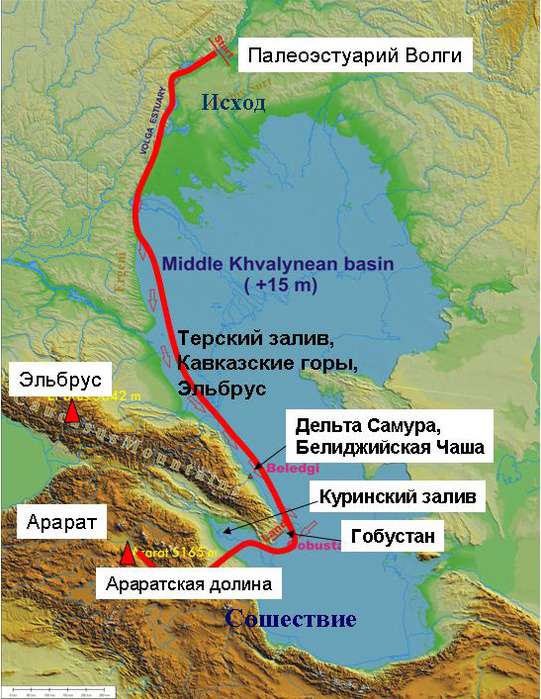
It was previously revealed that the voyage of the ark took place in the waters of Khvalynsky seas , most likely in the basin of the Turkmen phase of development Khvalynskaya transgressions with sea level on marks +15m abs. The area of the sea then was 809 thousand km² and more than 2 times the size of the water area of the modern Caspian Sea(380 thousand km²), and the volume of water reached 102 thousand km² (1.4 times more than the modern Caspian Sea). The seashores were winding especially on the northern coast, the length of the coastline (9458 km), however, was the smallest among Khvalynsky pools, (in high stands) but 1.6 times more than the modern one. The coastline was especially difficult north coast, where there were many bays, peninsulas and several islands. Most large bay went deep into land along the modern the Volga valley, and north of the turn Volga it continued in the form of a deep but narrow estuary, from where Noah's ark supposedly entered the sea. This - Volga paleoestuary .
Start of sailing (outcome). Let's start the reconstruction of Noah's voyage by establishing extreme points travel: loading on the ark (exodus) and disembarkation (descent). As for the latter, traditionally the place of descent is considered Mount Ararat V Lesser Caucasus, close to the coast Khvalyn Sea .
Now we will determine the place of the beginning of swimming. Given the elongation of the sea from north to south for 1600 km and the landing site near the southern coast, it can be assumed that Noah sailed south from the north. This is confirmed by data on Noah's ark. Need to collect a large number lumber for the Ark is supposed to start sailing With northern shores Khvalyn Sea , more precisely from the paleoestuary of the Volga. It was the only place in Caspian shores with rich stocks of forest-fin.
Now let's test this hypothesis according to the information from the source. In the Book of Genesis(chapter 9) it is described that shortly after the end of the voyage and disembarkation from the Ark (presumably near Ararat ) Noah had experience of tasting grape wine. But this experience was the first and therefore unsuccessful. Noah drank wine and fell naked in a tent, which caused ridicule even from his son Ham:
“…and he drank the wine, and became drunk, and lay naked in his tent. And Ham saw the nakedness of his father and, going out, told his brothers ... Noah woke up from his wine and found out what his younger son had done to him, and said: Cursed is Canaan, he will be a servant of servants to his brothers ” . (Genesis 9, 21-25)
How could it happen that such a righteous and blameless person as Elder Noah (he was already 601 years old) behaved so obscenely? After all, he was charitable, and even after swimming, the Lord himself blessed him! There can be only one answer: Noah did not know the insidious properties of wine, because before swimming he had never tasted it. This means that he came here from a country where grapes do not grow, i.e., in a colder country and Noah's homeland is located far north of Ararat and the Caucasus. And since the Ark covered the distance 1500-1600km, then you need to measure this distance from south coast Caspian to the north to get to the homeland of Noah. And then we hit the northwest coast Khvalynsky seas , to the paleoestuary of the Volga , somewhere around 50°N. Again, there is a fairly good agreement between biblical data and paleogeographic reconstructions.
Stages of Noah's voyage.
First leg of the swim . So, Noah sailed from north to south, from the paleoestuary Volga to the south coast of the Khvalyn Sea . It is most likely that at first Noah's Ark drifted slowly in the estuary of the Volga downstream until its confluence with the sea. And then the Ark moved south along West Bank Khvalynsky sea. Therefore, at the first stage of the voyage, which lasted 5 months (150 days), there is no information about the coast or other landmarks in the Biblical description of the trip, only flood events and the death of all living things are described. The reason for the lack of information about coastal features may be the absence of any remarkable features on the coast. If we accept our reconstruction, then this is quite understandable. Swimming took place in the Northern Caspian along flat low-lying shores, moreover, overgrown with reeds and coastal vegetation. So, from the ship this low coast was almost invisible. Only after 150 days the mountains appeared, or rather the tops of the mountains of Ararat.
“And the Ark stopped in the 7th month, on the 17th day of the month, on the mountains of Ararat” (Genesis 8, 4).
This name in the Bible means Caucasian mountains , and not only Greater Caucasus, but also Lesser Caucasus where is located Mount Ararat , the place of descent from the Ark.
Second phase. Let's try to determine where Noah could first see the peaks Caucasus mountains . If you sail along the western coast of the Khvalynsk Sea to the south, 700-800 km to 43 ° N, then this place can be determined at the modern Terek delta, then flooded up to +15 m abs by the waters of the Terek Paleo Bay. From here you can actually see good weather snowy peaks of the Caucasus, even Mount Elbrus. How far could Noah's Ark sail in 150 days swimming at a speed of 5km/day? It will be 150x5km=750km. Again, an amazing coincidence between the calculation of distances according to biblical data and paleogeographic reconstructions.
Third stage continued for another month and a half (45 days), the voyage took place along Caucasian coast:
“the water gradually decreased until the 10th month; on the first day of the 10th month, the tops of the mountains appeared" [Ararat ] (Genesis 9.5)
about 220-250km and be in the region of the mouth Samura between Derbent And Absheron Peninsula . Right here Caucasian mountains close to the shore Khvalyn Sea . Here in the deposits Turkmen stage of the Khvalyn Sea near the village of Biliji A bone bowl made by a man from a mammoth kneecap was discovered - the Bilijay bowl. Since mammoths did not live here at that time, it can be assumed that it was brought from the north by the Cro-Magnon tribe, who, like Noah, migrated from the basin Volga . Again, a good agreement between biblical, paleogeographical and archaeological data.
Fourth stage. The next transition lasting 40 days ended on 10.12.600IPH much to the south:
“After forty days Noah opened…the window of the ark…”( Genesis 8.6)
During this time, the Ark could sail 40x5km=200km. Let's measure south along the shore 200km and head south from Apsheron at the mouth of the Pirsagat river . What is so special about the coast? Here near Gobustan , among the rocky shores and convenient bays there could be another parking of Noah's ark.
Right here in Gobustan there are traces of a large anchorage of ancient ships and human settlements for many thousands of years from the Paleolithic to the Middle Ages. This is evidenced by numerous cave drawings ancient ships. Among them there are flat-bottomed ships similar to rafts, and they are the largest and most ancient, 9-10 thousand years old. One of them depicts 37 people sitting with bows at the ready, but without oars. They were probably warriors, among them two of the dead are lying, and one is standing, probably a priest or leader. Here you can again fix the coincidence of not only biblical, paleogeographic but also archaeological data.
Swimming final. Further, Noah's path probably ran through the Kurinsky Bay to the southwestern shore of the Khvalyn Sea, from where it was already very close to the city of Ararat and the Ararat Valley - the alleged place of descent from the ark. It is quite possible that at the final stage of the voyage from 01.01.601 RN to 27.02.601 RN, Noah's expedition explored southern coasts sea until it stopped in the Ararat valley. This place turned out to be more comfortable for Noah than the dry coast of the sea. The local landscape of the mountain woodlands of the Ararat Valley, irrigated by numerous rivers and streams, and rich in wild fauna, was more familiar, similar to the native forest-steppes of the Middle Volga region.
So, when superimposing the biblical description of the flood and Noah's voyage on the reconstructed events of the EEZ, one can note more numerous coincidences of these parameters, both quantitative and actual, which confirms the reality of the biblical flood events.
Conclusion. Now, after finding out all the details of Noah's voyage, it is possible to determine the place and time of this event in the natural processes of the EEZ. In terms of duration, these processes are incomparable with a difference of thousands of times: EEZ lasted 6 thousand years, A Noah's voyage - only about a year. It means that sailing on the Ark represents only a short episode against the background of longer EEZ events. Accordingly, the significance of these events is assessed differently. Based on the biblical text, human sins, the punishment of the Lord and the miraculous salvation of Noah were primary. And the flood was secondary, it was necessary as a background and motivation for the salvation of Noah's tribe and all mankind. The global flood or biblical flood was probably just one of the spring-summer floods during one of the high stands (+15 m abs.) Khvalynsk transgression.
In fact, the main process is the events of the Flood, and in nature it is the EEZ and the Khvalyn transgression, which began much earlier (by four thousand years) and continued for another two thousand years, until the end of the Pleistocene. This means that the biblical events of the flood and the voyage of Noah developed against the backdrop of much longer and larger-scale events of the EEZ and represent only a particular episode in the history of the EEZ. It is possible that Noah's voyage is not a unique event, but one of the episodes of mass migrations of the Late Paleolithic Cro-Magnon tribes from the Volga basin through the Khvalyn Sea to the Caucasus, Transcaucasia and further to the Middle East. This could be one of a series of targeted campaigns to the south of the more highly developed Cro-Magnon tribes of Northern Eurasia to discover and conquer new lands, the Caspian Sea and Central Asia, then inhabited by more primitive tribes of Neanderthals. This is confirmed by archaeological data, as on the Caspian coast there are Mousterian sites located on the Khvalyn terraces in the area of the Manas-ozen river (Amirkhanov, 2005), but there are no Late Paleolithic finds. The situation is similar for the entire Caspian region, where there is no Late Paleolithic, but Mousterian sites are known. (Amirkhanov, 2005). Their age is very young for a Mousterian, not older than 12-14 thousand years. this means that Neanderthal tribes lived on the coasts of the Caspian almost until the end of the Pleistocene. And at this time, starting from 40-35 thousand years ago, north of the Khvalyn Sea and the entire Cascade of the Eurasian basins And west of the Caucasus already inhabited by late Paleolithic tribes. A kind of refugium (shelter) was formed around the Caspian Sea and in Central Asia, where the Mousterian Neanderthal tribes lived here for more than 20-25 thousand years after their disappearance from Europe. (Doluhanov et al., 2007)
Noah's voyage on the Ark is presented as a campaign of an evolutionarily advanced Cro-Magnon tribe from the Volga basin to the south to conquer new lands occupied by tribes of primitive Neanderthals, who were supplanted by more highly developed Cro-Magnons at the end of the Pleistocene. They were pioneer conquerors like the conquistadors in America and the Russian Cossacks in Siberia.
- Khvalyn Sea
sea, Khvalisskoe Sea, the old Russian name for the Caspian Sea. Perhaps it comes from the ancient Russian name for the population of Khorezm - ... - Khvalyn Sea
(Khvalis Sea), the ancient Russian name of the Caspian ... - SEA in the Dictionary of thieves' jargon:
- Very … - SEA in Miller's Dream Book, dream book and interpretation of dreams:
If you hear the melancholy sound of the sea in a dream, it means. You are destined to a tedious and fruitless life, devoid of love and friendship ... - SEA in the Dictionary of Economic Terms:
OPEN - see OPEN SEA ... - SEA
(Gen 1:10) - this word is attached to the priest. writers to lakes, rivers, and in general to every large collection of waters, as well as ... - SEA in the Bible Encyclopedia of Nicephorus:
(slinger, shooter) - the name of two localities: Genesis 12:6 - this was the name of the oak forest near Shechem. This oak forest should not be confused with ... - SEA in the Big Encyclopedic Dictionary:
- SEA in the Great Soviet Encyclopedia, TSB:
part of the World Ocean, more or less isolated by land or elevations of underwater relief and differing from the open part of the ocean mainly ... - Khvalynskoe
or the Khvalis Sea - the old Russian name for the Caspian Sea (see resp. ... - SEA in the Encyclopedic Dictionary of Brockhaus and Euphron:
see Oceanography and ... - SEA in the Modern Encyclopedic Dictionary:
- SEA in the Encyclopedic Dictionary:
part of the World Ocean, isolated by land or elevations of the underwater relief and differing from the open part of the ocean in hydrological and meteorological regime. How … - SEA in the Encyclopedic Dictionary:
MOPE, -i, pl. -I, -hey, cf. 1. Part of the ocean - big body of water with bitter salt water. Swim by the sea. By sea … - Khvalynskoe
HVALYNSKOE SEA (Khvalisskoe sea), other Russian. name Caspian ... - SEA in the Big Russian Encyclopedic Dictionary:
SEA, part of the World Approx., isolated by land or elevations of water. relief and different from the open part of the ocean hydrological. and meteorol. mode. … - Khvalynskoe
Or the Khwali Sea? the old Russian name of the Caspian Sea (see resp. ... - SEA in the Encyclopedia of Brockhaus and Efron:
? see Oceanography and... - SEA in the Full accentuated paradigm according to Zaliznyak:
mo "re, seas", mo "rya, sea" th, mo "ryu, seas" m, mo "re, seas", mo "rem, seas" mi, mo "re, ... - SEA in the Dictionary of Epithets:
About size, length, depth. Boundless, limitless, bottomless, measureless, infinite, boundless, boundless, all-encompassing, deep, vast, boundless, boundless, boundless, vast, wide. ABOUT … - SEA in the Dictionary of synonyms of Abramov:
see a lot || wait by the sea for weather, across the sea, a drop in ... - SEA in the dictionary of Synonyms of the Russian language:
kara sea, caspian, multitude, abundance, pont, seram, sulawesi, sulu, fiji, … - SEA in the New explanatory and derivational dictionary of the Russian language Efremova:
cf. 1) a) Part of the World Ocean, isolated by land or elevations of underwater relief. b) very big lake with bitter salt water. V) … - SEA
m`ore, -i, pl. -`I, ... - SEA in the Dictionary of the Russian Language Lopatin:
Mʻore, -ya, use. in the names of parts of the lunar landscape, for example: M`ore of the Rains, M`ore of Crises, M`ore ... - SEA
Sea, -I, use. in the names of parts of the lunar landscape, for example: the Sea of Rains, the Sea of Crises, the Sea ... - SEA in the Complete Spelling Dictionary of the Russian Language:
sea, -i, pl. -I, … - SEA in the Spelling Dictionary:
m`ore, -i, use. in the names of parts of the lunar landscape, for example: m`ore of rain, m`ore of crises, m`ore ... - SEA in the Spelling Dictionary:
m`ore, -i, pl. -`I, ... - SEA in the Dictionary of the Russian Language Ozhegov:
part of the ocean - a large body of water with bitter-salty water To sail by the sea. By the sea and by the sea. N- sea and on ... - SEA in the Dahl Dictionary:
cf. the accumulation of salty bitter waters in vast depressions, rifts of the earth's surface. In general, all these waters are called the sea, as opposed to land, land, ... - SEA in Modern explanatory dictionary, TSB:
part of the World Ocean, isolated by land or elevations of the underwater relief and differing from the open part of the ocean by the hydrological and meteorological regime. How … - SEA in the Explanatory Dictionary of the Russian Language Ushakov:
seas, pl. i, cf. 1. part of the water shell of the earth, a huge depression, a depression in the earth's surface, filled with bitter-salty water and connected ... - SEA in the Explanatory Dictionary of Efremova:
sea cf. 1) a) Part of the World Ocean, isolated by land or elevations of underwater relief. b) A very large lake with bitter-salty water. … - SEA in the New Dictionary of the Russian Language Efremova:
cf. 1. Part of the World Ocean, isolated by land or elevations of underwater relief. ott. A very large lake with bitter-salty water. ott. Large … - SEA in the Big Modern Explanatory Dictionary of the Russian Language:
I cf. 1. Part of the World Ocean, isolated by land or elevations of underwater relief. ott. A very large lake with bitter-salty water. ott. … - MEDITERRANEAN SEA in the Encyclopedia of Brockhaus and Efron:
? so named because of its position among the lands that made up the entire known ancient world? belongs to the most remarkable of…
On geographical map In Russia, you will not find a sea with the name Khvalynskoe. The thing is that in ancient times this was the name of the Caspian Sea, which in the entire history of its existence had about 70 names from different tribes and peoples. Khvalynsky (or Khvalissky) he was called in ancient Rus' by the name of the Khvaliss - the inhabitants of Khorezm, who traded in the Caspian Sea.
The Caspian Sea, as an endorheic basin, is highly susceptible to water level changes, usually caused by climate change. For example, over the last quarter of the 20th century, the level of the Caspian Sea has risen by more than 2 meters, causing destruction on the shores. But these fluctuations are nothing compared to what happened before.
During the Valdai glaciation (70-11 thousand years ago), the level of the Caspian Sea rose by tens of meters, flooding vast territories. This sea basin is commonly called the Khvalynsk Sea.
As scientists suggest, 17 centuries ago, due to a sharp warming that caused the melting continental ice and permafrost, superflood in the river valleys caused the level of the Caspian Sea to rise so much that water cascaded onto the underlying lands, causing a real flood.
The era of floods with a sharp rise in water in the Caspian - the so-called Khvalyn transgression (the advance of the sea on land) - lasted 5-6 thousand years, and the cycles of water level fluctuations can be combined into three waves, each of which lasted about 2 thousand years.
The rise time of the water was very short; this is evidenced by the absence of basal gravels and coarse deposits. The level rise in the Khvalynian time was an extraordinary event both in scale and in speed. This rise is estimated by scientists at 178 meters: it reached +50 meters above sea level. At the same time, the rise occurred in 100-200 years.
Sea level fluctuations were significant: with speeds of up to 2 meters per year vertically, and up to 20 kilometers per year - the speed of movement of the coastline. And when we compare it with modern catastrophic rises in the level of the Caspian Sea (for example, the last rise was 2.5 meters in 25 years), it turns out that modern speeds are an order of magnitude lower, although they are already considered catastrophic.
The area of the Khvalyn basin was about one million square kilometers, let's add the area of the Volga estuary and the Aral-Sarykamysh basin and as a result we get the area of net flooding - one million square kilometers.
During the most significant early Khvalynian transgression, the level of the Caspian Sea rose by 80-90 meters, turning the Volga to Saratov into an open sea basin. The Khvalyn Sea spread further up in the form of a bay-estuary (approximately to modern Cheboksary) and had a length of more than two thousand kilometers. Thus, the waters of this ancient basin ranged from the Ergeni ledges in the west to the Ustyurt chinks in the east, in the north they reached the foothills of the Common Syrt, penetrating along the Volga valley to the mouth of the Kama. The sea flooded the Kura depression, the coasts of the Caucasus, the West Turkmen lowland and the low Karakum.
Throughout the Khvalynian time, the water level was constantly maintained quite high: +20 - +50 meters. The salinity of the Khvalyn Sea was close to the salinity of the modern Caspian, it was inhabited by various microorganisms (ostracods, foraminifers, diatoms) and mollusks. According to the composition of the latter, the nature of the transgression is well reconstructed.
Changes in the connection conditions of the ancient seas with the ocean influenced living organisms, some of which died, others changed, adapting to new conditions. If the exchange of water with the ocean increased, then the salinity increased and the fluctuations in the temperature of the Caspian Sea decreased. The disruption of communication with the ocean led to the desalination of the Caspian Sea and an increase in temperature fluctuations in different seasons of the year. Thus, during periods of salinity, mollusks, oppressed by high salinity, had thinner shells than mollusks of the same species, but living in a period of low salinity of the sea. Based on this, it was possible to establish the duration and conditions for changing the periods of desalination and salinization.
14-15 thousand years ago, the waters of the Khvalyn Sea subsided, forming various landscapes. Marine sediments became the parent rocks for soils that formed over time and are still characterized by increased salinity, as a sign of some kind of “kinship” with the sea. And now it is safe to name the reason why the soils of the "bottom" of the former river - the strait - differ from its "shores" - the slopes of the valley.
The Khvalynsk Sea, which retreated many thousands of years ago, left behind rich minerals, including shell rock, whose reserves in the right-bank Voskresensky region are one of the largest in Russia.


