Australia and Oceania. General features of the political and socio-economic geography of Australia and Oceania
Stages of formation. The discovery by Europeans of Australia (its western coast) dates back to the 17th century, when the Netherlands East India Company expected to find on the shores southern mainland inhabited lands. Prior to Tasman's voyage in 1642, Australia was considered part of the vast Southern Continent. open area was called New Holland, under this name it existed until 1814, when the book of the researcher Flinders was published, in which it was proposed to rename New Holland to Australia.
The voyages of the Dutch J. Janszon (1605-1606), the Spaniard L. V. de Torres (1606), who discovered the island New Guinea, and A. Tasman (1642), who proved that Australia is a separate mainland, and explored a number of islands in Oceania, as well as circumnavigation Englishman J. Cook (60-70s of the XVIII century) and his discoveries in South Polynesia laid the foundation for colonial conquests in the region.
In the 70-80s. 19th century exploration of the Moluccas, Java and West Bank New Guinea was studied by the Russian traveler N. N. Miklukho-Maclay.
Oceania includes islands in the central and southwestern parts Pacific Ocean. There are three island regions - Melanesia, Polynesia and Micronesia. Melanesia includes islands located in the southwestern part of the Pacific Ocean: New Guinea, Solomons, New Hebrides, the Bismarck archipelago, New Caledonia, Fiji, Santa Cruz, etc. In the central part of the Pacific Ocean there are islands of Polynesia: the Tonga archipelago, Samoa Cook Island, Tahiti, Tuamotu, Easter, Marquesas. Micronesia includes islands located closer to Asia: Gilbert, Marshall, Mariana, Caroline, Nauru, Banoba.
Decolonization in Oceania began in the 60s. XX century, but at the beginning of the XXI century. Oceania still has a significant number of self-governing territories. By the beginning of the XX century. Great Britain had the most extensive possessions: Australia, the Gilbert and Ellis Islands, the Cook Islands, Niue, New Zealand, New Guinea (British), the Norfolk Islands, Pitcairn, the southern part of the Solomon Islands, the Tonga Islands, Fiji, Fanning and Tokelau. The possessions of Germany were: the Caroline, Marshall, Mariana Islands, the island of Nauru, New Guinea (German), the Bismarck Archipelago, Emperor Wilhelm Land, Northern part Solomon Islands, Western Samoa. The possession of the Netherlands was New Guinea (in the XVI-XVII centuries), the possession of the USA - Hawaiian Islands, Guam Island, Eastern Samoa, Wake. France owned New Caledonia, French Polynesia (five archipelagos, 130 islands), etc.
Forms of government and government. At the beginning of the XXI century. There are about 30 states and territories in the region.
Most of the states unitary republics. Federal republics- Commonwealth of Australia, Federated States of Micronesia.
constitutional monarchies are Tonga, Samoa. TO non-self-governing territories include US possessions - American Samoa, Guam (status of an unincorporated territory of the United States), Midway Islands, Wake, Baker, Johnston Atoll, Kingman Reef, Navassa Islands, Palmyra Atoll, Howland Island, Jarvis Islands; possessions of New Zealand - Tokelau, Cook Islands, Niue ("free association"); Great Britain - Pitcairn; Australia - Christmas Island, Norfolk, Cocos (Keeling) Islands, Ashmore and Cartier Islands, Territory of the Islands coral sea, Hard and McDonald Islands; France - Wallis and Futuna Islands, French Polynesia, New Caledonia.
Independent member states of the Commonwealth are Australia, Vanuatu, Samoa, Kiribati, Nauru, New Zealand, Papua New Guinea, Solomon Islands, Tonga, Tuvalu, Fiji.
The main events of the XX century.
1900- The Hawaiian Islands, captured from Spain (1898), received the status of a US territory.
The Cook Islands (in 1888-1901 - a protectorate of Great Britain) were transferred to the control of New Zealand.
1901- the union of the Australian colonies of Great Britain into the Commonwealth of Australia, which received the status of a dominion.
The island of Niue was transferred by Great Britain under the control of New Zealand.
1903- the unification of the islands of Tahiti, the Marquesas, and others into the colony of French Oceania.
The Cocos (Keeling) Islands are included in the British colony of Singapore.
1905- the southeastern part of the island of New Guinea (in 1884-1905 - a protectorate and colony of Great Britain) was transferred to the control of Australia.
1906- Establishment of joint ownership (condominium) of Great Britain and France on the islands of New Hebrides.
Transfer of the British colony of Papua under the control of the Commonwealth of Australia.
1907- New Zealand gained dominion status british empire.
1916- Ellis and Gilbert Islands, in 1892-1916. former protectorate of Great Britain, received the status of a colony.
1920- after the defeat of Germany in the First World War, under the mandate of the League of Nations, the Mariana, Marshall and Caroline Islands were transferred to Japan (these islands were captured by it in 1814); under the control of the Commonwealth of Australia - German possessions on the island of New Guinea, Emperor Wilhelm Land, the Bismarck Archipelago; New Zealand - the islands of Nauru and Western Samoa.
1925- Tokelau Islands, in 1877-1925. formerly a protectorate of Great Britain, came under the control of New Zealand.
1931- The Commonwealth of Australia and New Zealand (formerly the dominions of the British Empire) received full independence in internal and external affairs.
1946-1947- the mandate system of the League of Nations was replaced by the UN trusteeship system: the Marshall, Mariana and Caroline Islands (formerly mandated territories of Japan) became United Nations trust territories under US administration and were named the Trust Territory of the Pacific Islands; Western Samoa passed into New Zealand custody; Papua New Guinea - Australia; Nauru - UK, Australia and New Zealand.
New Caledonia, which had been a colony of France since 1853, received the status of an overseas territory.
1948- The Tokelau Islands are included in the territory of New Zealand.
1949- unification of the north- and south-eastern parts of the island of New Guinea into a single administrative-territorial unit Territory of Papua and New Guinea.
1950- the island of Guam (US possession) was granted local self-government and the status of an unincorporated territory of the United States.
1951- the islands of Ryukyu, Bonin, Volkano, Parese-Vvela, Markus, Daito, formerly the possessions of Japan, came under US control.
1955- Cocos (Keeling) Islands transferred to Australian administration.
1958- renaming of French Oceania (Society Islands, Tahiti, Marquesas, Tuamotu) into French Polynesia, which received the status of an overseas territory of France.
Christmas Island, formerly part of the colony of Singapore, came under the control of Australia.
1961- The Wallis and Futuna Islands (Horn Islands), which had been a protectorate of France since 1888, received the status of an overseas territory.
1962- Western Samoa gained independence.
1965- The Cook Islands were granted the status of a self-governing territory associated with New Zealand.
1966- the island of Nauru received internal self-government, and in 1968 - independence.
1970- Fiji Islands, since 1874 former colonies Great Britain, became a dominion within the Commonwealth; in the same year proclaimed an independent state.
Termination of the protectorate of Great Britain over the kingdom of Tonga, granting it independence.
1973- Papua New Guinea received internal self-government.
1974- The island of Niue received the status of a self-governing state in free association with New Zealand. The Ellis Islands separated from the Gilbert Islands (now Kiribati) and received the name Tuvalu (since 1975 - a separate British colony).
1975- The Northern Mariana Islands left the Trust Territory of the Pacific Islands, whose population voted for the status of free association with the United States.
Papua New Guinea proclaimed independence.
1976-1977- British possessions of the Solomon Islands (protectorate) and Kiribati, part of the territory of New Zealand - Tokelau - received the status of internal self-government.
1978- an agreement to terminate US custody of the Commonwealth of the Northern Mariana Islands.
Granting independence to Tuvalu, the Solomon Islands, former Commonwealth states.
1979- granting independence to Kiribati, which was part of the Commonwealth.
1980- granting independence to Vanuatu.
1983- the population of the Federated States of Micronesia and the Republic of the Marshall Islands voted in a referendum for free association with the United States.
1984- provision of internal self-government for New Caledonia. A referendum in the Cocos (Keeling) Islands approved their formal accession to the Commonwealth of Australia.
1986- U.S. custody of the Federated States of Micronesia and the Republic of the Marshall Islands has been terminated.
1989- Abolished direct French rule in New Caledonia.
1990- Granted independence to the Federated States of Micronesia and the Republic of the Marshall Islands.
1994- U.S. guardianship over the Republic of Palau was terminated, and its independence was proclaimed.
1997- The independent state of Western Samoa became known as Samoa. Sovereign Democratic Republic Fiji became known as the Republic of the Fiji Islands.
Territorial disputes. It would seem that scattered island states with a small population and a diverse national composition can hardly participate in global disputes over state borders. However, such controversies exist. They are caused by the colonial past and the fact that the islands have repeatedly changed owners - the mother country. Disputes arise because of small uninhabited reefs and atolls. As a rule, on maps published in Russia, the ownership of the islands is not indicated.
33. political map Australia and Oceania
Australia, New Zealand and other small and large islands in the central and southwestern parts of the Pacific Ocean, due to a certain commonality of historical and geographical development, are considered as a special region - Australia and Oceania.
Politically and economically, this region is diverse. In this region, highly developed Australia and New Zealand, small backward island countries and some territories that are still colonies adjoin.
Australia, or the Commonwealth of Australia, is a state that is located on the mainland of Australia, the island of Tasmania and many small islands.
Australia is a federal state within the British Commonwealth, which is led by Great Britain.
The first Europeans to set foot on Australian soil were the Dutch V. Janszon (1606) and A. Tasman (1642). The beginning of European colonization was laid by the British (James Cook, 1770). The white colonizers expelled the indigenous people from the lands and killed them, later the natives were forcibly relocated to the reservations. Initially, Australia was a place of exile for criminals from Great Britain, but in the 10th century. there was a discovery of deposits of gold and other minerals. All this led to an increase in the flow of free settlers to the region. Australia is a country of migrant capitalism.
In 1901, six colonies united to form the Commonwealth of Australia, which received the status of a dominion of Great Britain. In 1931, he was granted complete independence from the metropolis. Australia currently takes an active position on a number of major international issues, is one of the initiators of the South Pacific Nuclear Free Zone Treaty, and takes part in UN peacekeeping activities. Australia and New Zealand are members of the South Pacific Forum (SPF), the South Pacific Commission (SPC), the Pacific Economic Cooperation Council (SPEC) and other international agreements.
New Zealand is a state within the British Commonwealth, which is located on two large islands (North and South) and a number of smaller ones. It has been a colony of Great Britain (since 1840).
In 1907, New Zealand received the status of a dominion, and in 1931 it acquired the right to independence in its affairs (foreign and internal). In the modern world, New Zealand is a highly developed industrial and agricultural country.
Oceania is the largest cluster of islands on the planet (about 10 thousand) in the central and southwestern parts of the Pacific Ocean.
The total area of Oceania is over 1 million km 2, New Zealand is part of Oceania.
At the end of the X!X century. happened colonial partition islands of Oceania.
In the 1960s there was a collapse of the colonial system, which covered Oceania.
From book Economical geography author Burkhanova Natalia1. Political map of the world The political map shows the form of government, state structure, major political and geographical changes, and much more. The main content of the political map of the world consists of the following elements: the formation of independent
From the book Youth of Science. The life and ideas of economic thinkers before Marx author Anikin Andrey Vladimirovich31. The political map of Africa The mainland occupies 1/5 of the land area of the globe, there are 55 sovereign states on the continent, most of which were until the 20th century. were colonies. The population is over 600 million people. scientific literature Africa is divided into five sub-regions
From the book Sonin.ru - Economic Lessons author Sonin Konstantin IsaakovichPolitical economy and economics In the last decades of the XIX century. the term political economy began to go out of fashion in the West and was replaced by the word economy. It is now used in a double sense: in the sense of economy, the totality of the production relations of society
From the book World Economy author Kornienko Oleg Vasilievich From the book RUSSIAN NATIONALISM - THE ENGINE OF THE REFORMATION IN RUSSIA author Gorodnikov SergeyThe Political Economy of Compromises Marx and Chernyshevsky produced almost simultaneously a similar general characteristics Mill as a political economist. Quoting the place where Mill speaks of the injustice of distribution under capitalism, Marx, in the first volume of Capital, points out: “In order to
From the book POLICY IN THE UNDERSTANDING OF THE NATIONAL DEMOCRAT author Gorodnikov Sergey From the book Economic Theory: Textbook author Makhovikova Galina AfanasievnaChapter 4 POLITICAL ECONOMY Political science is amazing interesting area human knowledge, simply because politics is an exciting subject to study and an inexhaustible source of topics for discussion. “Elections are my football,” he told me when meeting
From the book Default, which could not be by Gilman MartinQuestion 35 Economy of Australia and New Zealand Answer Several groups of countries are distinguished in the Oceania region: Melanesia (Fiji, Vanuatu, etc.), Micronesia (Guam, Kiribati, etc.), Polynesia (New Zealand, Samoa, Tonga, etc.) and Australia (the state of Australia, as well as the island
From the book Youth of Science author Anikin Andrey VladimirovichPolitical tragicomedy At the congress of the demo-nomenklatura movement “Our Home is Russia”, held in August, V. Chernomyrdin made two important statements on behalf of those forces that stand behind the current regime and determine its policy. Firstly, that this movement should openly
From the book Day trading in the Forex market. Profit Strategies by Lyn KettyPOLITICAL Fever The stupidity of the first persons of the regime no longer surprises, but touches. The first deputy chairman of the government, Nemtsov, who imagines himself the future president of the country, once again, like a Don Quixote, declared war not on his stomach, but to the death of another windmill. On that
From the author's book19.4. Classical Political Economy Having won positions in the sphere of circulation, the bourgeoisie penetrates into the sphere of production. This is immediately reflected in the theory: it is proved that the source of wealth is production, and not trade, in which only the created
From the author's bookPolitical struggle and society If we try to explain the events of the subsequent period in the process of Russian reforms, the first thing that should come to mind is the influence of internal political struggle on it. Although many observers, in their search for a simple explanation of all
From the author's bookPolitical economy and economics In the last decades of the XIX century. the term political economy began to go out of fashion in the West and was replaced by the word economy. It is now used in a double sense: in the sense of economy, the totality of the production relations of society and
From the author's bookPolitical arithmetic The English king Charles II, most of all in his life, wanted to surpass his august relative, the French king, in something Louis XIV. He arranged balls and fireworks with an eye on Versailles. But he had much less money than
From the author's bookOwen and Political Economy Owen was the first to draw anti-capitalist conclusions from the principles of the classical school. However, from bourgeois classical political economy, Owen took only what he needed for his system, ignoring and even outright rejecting much more.
From the author's bookImportant economic indicators for Australia Gross domestic product - measures the total production and consumption of goods and services in Australia. GDP is calculated by adding household, business, government spending and net purchases abroad.
Australia is located entirely in the southern hemisphere. It is the smallest of the six continents on our planet. Almost in the middle, the mainland crosses the southern tropic, so most of The continent lies in a hot climate zone. Due to its relatively small size and due to the fact that Australia is surrounded on all sides by oceans, it is also called the mainland-island. From the north, west and south, Australia is washed by waters indian ocean, and from the east - the Pacific. Oceania is the name given to the islands lying in the central and southwestern Pacific Ocean east of Australia, between 28°N. and 53° S, 130° E and 105°W In total, there are about 7,000 islands in Oceania, some of which form archipelagos.
The ancient Greeks spoke about the existence of a mainland somewhere in the south of the Indian Ocean. However, Australia was discovered by Europeans only in the 17th century. The Dutchman Willem Janszoon, who was in the service of the Dutch East India Company, reached the western coast of the Australian Cape York Peninsula in 1605 on the ship Dsifken, which he considered part of the island of New Guinea. In 1606, the Spaniard Torres sailed through the strait between New Guinea and Australia. And only in 1653 the Dutch navigator Tasman rounded the mainland from the south.
After exploring the east coast of Australia in 1770 by the navigator James Cook, the British soon laid the city of Sydney, and the settlement of Australia began. Basically, criminals sentenced to hard labor referred to the settlement here. However, in the conditions of the Australian lack of water, dry and hot climate, not everyone survived, and the survivors usually stayed here forever. Thus began the colonization of the mainland, which was accompanied by the ruthless extermination of the indigenous population located in the reservations.
As a result, the Australian nation was formed mainly by immigrants from Great Britain and Ireland. The Anglo-Australians count their history from the arrival of the "First Fleet" - an armada of 11 sailing ships, moored to the coast of Australia in January 1788 and delivered the first group of convicts and the convoy accompanying them. appeared at the end of the 19th century. immigrants from Italy, Greece, Yugoslavia, Germany, the Netherlands completed the European colonization of the continent for the development of gold mining and sheep breeding.
Australia is the driest continent on Earth. Three quarters of its territory belongs to the arid zone. It does not rain in the desert for several years, but when suddenly showers fall on the parched land, the driest continent turns into the wettest. Dry riverbeds and empty lakes overflow with water. After the rains, the desert blooms with bright green colors, but such a picturesque time lasts no more than two weeks.
The location of the continent in the tropical zone determines the large influx of solar radiation. From the east, the mainland is washed by the warm waters of the East Australian Current and is influenced by the Pacific southeast trade winds, which carry a lot of moisture. However, these winds lose their moisture in the mountains and do not deliver it deep into the mainland. Therefore, in the central western regions dry tropical air dominates throughout the year. Its temperature in summer is +30°С and higher, and in winter +10-+15°С. Precipitation is only 250-300 mm. The climate of the Central Plain is continental and dry. A branch of the cold current of the West Drift runs along the western coast of Australia, and temperatures are somewhat lower here. The south of the mainland and the island of Tasmania lie on the border of the subtropical and temperate zones, and western air transport prevails over them - the climate is moderately warm. Overall, the continent receives five times less precipitation than Africa.
In the north and northeast of the mainland there is a zone of variable wet and humid rainforest. To the south and west, they are replaced by woodlands and savannahs, which turn into semi-deserts and deserts. Australia ranks first among the continents in terms of the relative area of deserts and last in terms of forest area. Forests only cover this continent in some places. Among plants, 75% are endemic. IN in large numbers eucalyptus, acacia, araucaria, tree ferns, grass tree, various ficuses and rare herbs grow.
The species composition of animals is limited, and even more so than among plants, it includes ancient species. Kangaroo, koala, platypus, echidna are found here.
There are many amazing birds in the country, such as black swans, emu, lyrebird, cassowaries, birds of paradise, etc. Crocodiles live in swamps, poisonous snakes and lizards, as well as spreaders of various diseases - mosquitoes, mosquitoes and flies. Basically, Australia is hard to imagine without evergreen eucalyptus trees reaching a height of 100-150 m, acacias and kangaroos.
By tradition, high state guests visiting the country are presented with a very rare and charming creature - a herbivorous Australian wombat bear cub.
Australia has a flat terrain. Most of the territory is a plain and about 95% of the surface does not exceed 600 m. In the center of the continent there are separate fragments of ancient mountains, in particular, a local landmark - Ayers Rock, or Uluru (Sacred). It rises on a flat plain overgrown with hard grasses. As a result of wind erosion, the monolith acquired the shape of a rounded “cobblestone” 350 m high, which changes its color depending on the angle of incidence of sunlight. According to Aboriginal legends, the rock is visited by the Wanambi serpent, the supreme judge of all mortals. This place attracts numerous tourists, film and photographers with its mysterious beauty. The most significant mountain system exists only in the east of the mainland along the Pacific coast.
According to the topography of the surface, the following are distinguished: the Western Australian Plateau, the Central Plain and the East Australian Mountains. In geological terms, the mainland is based on the Precambrian platform, the crystalline foundation of which in some places comes to the surface in the north, west and in the central part, forming shields. In the rest of the territory it is covered with sedimentary rocks of the continental and marine origin, the most powerful in places of platform deflections. The formation of mountains in the east of the mainland belongs to the Hercynian folding, later they were severely destroyed, and in the Alpine period they were rejuvenated. Here, from north to south, the Great Dividing Range stretches with a steep, strongly dissected eastern slope and a gently stepped western slope, passing into hilly foothills (downs). In the more elevated southern part of the range, in the Australian Alps is highest point Australia - Mount Kosciuszko (2228 m).
Australia long time(from the end of the Mesozoic) exists in isolation from all other continents. However, during the Quaternary, the landmass between Australia and Southeast Asia was for a time more extensive than it is at present. A solid land "bridge" between the two continents never existed, because if it were, the Asian fauna would have to penetrate into Australia, which did not happen. In all likelihood, in the Late Quaternary, on the site of shallow basins separating Australia from New Guinea and southern islands Sunda archipelago (their modern depths do not exceed 40 m), there were vast areas of land formed as a result of repeated fluctuations in sea level and uplifts of the ocean floor. It is believed that the Torres Strait, which separates Australia from New Guinea, was formed quite recently. The Sunda Islands could also be periodically interconnected by narrow strips of land or shoals. Most land animals could not overcome such an obstacle. People gradually, by land or through shallow straits, penetrated through the Lesser Sunda Islands to New Guinea and the Australian mainland. At the same time, the settlement of Australia could occur both directly from the Sunda Islands and the island of Timor, and through New Guinea. This process was very long, probably, it stretched for whole millennia during the late Paleolithic and Mesolithic. At present, on the basis of archaeological finds on the mainland, it has been established that a person first appeared there about 40 thousand years ago.
Australia is still a fairly remote continent for international communications, especially with Europe. Southeast Asia is closest to Australia. The mainland is connected with it by archipelagos and inland seas. That is why it is believed that Australia could have been inhabited by people only from the north, i.e. from the side South-East Asia. This is confirmed both by the anthropological features of modern Australians and by paleoanthropological finds. It is also obvious that a modern type of man penetrated into Australia, i.e. the settlement of the mainland could not have occurred before the second half of the last ice age.
The outlines of the mainland have a compact shape, and its coastline slightly cut. The shallow Gulf of Carpentaria with the pointed cape of Cape York in the north and the Great Australian Bight and the island of Tasmania in the south stand out. Significant difficulties for navigation are ridges of coral islands that form the famous Bolshoi off the east coast. barrier reef. Based on differences in topography, climate, and vegetation, four natural areas: Northern, Eastern, Western and Central Australia. Eastern Australia is the highest and wettest part of the mainland. Western Australia is a region of plateaus and remnant mountains. Central Australia is mostly low-lying plain. The western and central regions are the driest and hottest parts of the continent with a predominance of deserts. Northern Australia- This is an area of elevated and low plains and low mountains.
There are few rivers on the mainland - 60% of the territory has no surface runoff into the ocean at all, temporary watercourses are characteristic. The food of most rivers is rain, and in the Australian Alps it is mixed. The most big river Australia - Murray with a tributary Darling. The length of the river is 2508 km, its source is in the Australian Alps, and it flows into the eastern part of the Great Australian Bight.
There are many endorheic lakes on the mainland, which are filled with water only during rains, and the rest of the time they accumulate salt. There is especially little moisture in the basin of the largest drying lake Eyre, located 16 m below sea level in the center of the continent. It is a single body of water only during rare but heavy rains. However, there are large reserves of groundwater on the mainland. Most of the artesian basins are located between the plateaus of Western Australia and the Great Dividing Range.
Australia is rich in mineral resources. The geological structure of the mainland determined the location of mineral deposits. The crystalline rocks of the foundation of the platform contain deposits of iron, copper, lead-zinc, uranium ores, tin, gold, and platinum. Deposits of phosphorites, common salt, hard and brown coal, oil, and natural gas are confined to sedimentary rocks.
At the end of the XIX century. Australia became famous mainly for its gold mining and its sheep breeding. In the 1960s-1970s. large deposits of minerals were discovered on its territory. New discoveries made on the continent in recent years have pushed the country to one of the first places in the world in terms of reserves of ores of ferrous, non-ferrous and rare metals, coal, and uranium. Many deposits occur at shallow depths and are developed by open pit mining. The country's mining industry is one of the most developed in the world. Australia is the world's largest exporter of coal, and is also among the leaders in the extraction of iron ore, gold, copper and diamonds.
Iron ore has been explored and mined in many areas of Australia (Kimberley, Queensland, New South Wales, near Yampi Bay, Tasmania, etc.). especially important economic importance have South Australian iron ore in the Flinders Mountains, near the cities of Port Augusta and Iron Knob.
In the west, on the ancient Australian shield, there are widely known gold-bearing fields of Kalgoorlie, Coolgardie, Dundas, Murchison, Pilbara, and others. A rich gold-bearing area was found in the southern part of the eastern mountain belt (Victoria). Here, on the Balla-rat and Bendigo plateaus, the deposits are riddled with rich gold-bearing quartz veins. Significant gold deposits have been discovered in the northern part of the eastern mountain belt, in Queensland in the basins of the Burdekin (near the city of Charters Towers) and Fitzroy (near Rockhampton) rivers. Platinum deposits have been discovered in Tasmania.
Australia has large reserves of non-ferrous metals. In the eastern mountain belt, polymetallic silver-lead and zinc deposits are concentrated in Queensland (Mount Isa), in the Broken Hill area (in New South Wales). Silver-lead ore is found in the west of Australia, in the area of the Ashburton-Gascoigne rivers. Magnetite, apatite, fluorspar are mined from pegmatite veins in the vicinity of Broken Hill. The most famous are the tin ore deposits in the west (Mount Bischof) and northeast of the island of Tasmania, in the north of New South Wales, in the mountains of New England, in Queensland (Gilberton). The country is very rich in copper ores, the deposits of which have not yet been fully explored. Currently great importance have copper deposits in Tasmania (Mount Lyell) and in the Cloncurry area.
Uranium ores have been found at Rum Jungle (Northern Territory), Radium Hill, Mary Kaglin ( South Australia), in the state of Queensland, etc. Antimony, bismuth, nickel, and diamonds are found in New South Wales.
As of 2012, Australia's proven copper reserves amounted to
- 86.0 million tons, aluminum - 6000.0 million tons, zinc - 70.0 million tons, lead -
- 36.0 million tons, nickel - 20.0 million tons, tin - 240.0 thousand tons, gold - 7400 tons, iron ore - 35.0 billion tons (Table 2.2) 1 .
Table 2.2
Reserves of mineral ores in Australia in 2008-2012
1 See: URL: http://www.cmmarkct.ru/countrics/austral.htm
In terms of coal reserves (very high quality), Australia ranks first among the countries of the southern hemisphere. Its richest deposits are located in New South Wales, mainly around the cities of Newcastle and Sydney. 75% of all coal resources of Australia are concentrated here. The coal basins in Queensland (Clairemont) and in the Brisbane region are of great industrial importance. Hard coal is found on the coast of Western Australia and in the east of Tasmania. In the state of Victoria there are deposits of brown coal, which is widely used to operate power plants.
There are more than 130 oil and gas fields in the country. Among them, nine belong to the category of large and 16 - medium in terms of reserves (5-45 million tons). Commercial reserves (50 million tons and more) contain Kingfish, Marlin, Barracut. Most of the commercial oil and gas reserves of Australia are concentrated in two areas - on the shelf (Gipsland in the Bass Strait (Barracut, Snapper, Marlin, Kingfish, Halibet fields) and Carnarvon (Barrow) off the northwestern coast) and in the intracontinental Inland East Australian basin, confined to the Great Artesian Basin (deposits Tirrawarra, Murari, Gidzhilpa, Mumba).
Gas outlets cause the formation of mud hills that emit hot salty mud (mud springs). They are found in the basins of the Bogan, Paru, Bullu rivers, on the plain of Lake Eyre, etc.
Most of the hydrocarbon resources (80%) are located at a depth of 1-3 km. Oils are light (density 790-810 kg/m), low-sulfur. Prospects for the growth of reserves are associated with the continental basins (Inland East Australian, Amadies, Perth, etc.), as well as with the waters of the northwestern shelf and the Gulf of Carpentaria. In the Blue Mountains, northwest of Sydney, there are significant deposits of bituminous oil shale.
The country is heavily mining rutile, zircon, ilmenite and other valuable minerals in coastal sands that stretch for 80 km on both sides of the border between Queensland and New South Wales. Many deposits occur at shallow depths and are mined by open pits.
One of the main sectors of the Australian economy is agriculture. Its share in Australia's GDP is 12%. About 136,000 farms and pastoralists cover 61% of the country's area, combining irrigated land with rainfed fields.
Cereals, oilseeds and legumes are grown on a large scale in Australia. The share of area for wheat cultivation is one of the largest in the world. Australia also supplies the world market with a significant amount of sugar cane, cotton and tropical fruits.
One of the important components of the country's agriculture and exports is winemaking. The states of New South Wales, Victoria, Western and South Australia are home to the four largest wine regions: Barossa Valley, Sunrise, Margaret River and Hunter Valley.
There is substantial income from the export of meat, including beef, pork and lamb. Indonesia is the largest consumer of Australian meat.
The share of fisheries and aquaculture in agricultural production is constantly increasing. Currently, it is about 32%. The main seafood exported by Australia is lobster, shrimp, tuna and abalone.
One of the most important products of Australian agriculture is wool. The Australian wool industry is recognized worldwide for producing the highest quality mutton. Since 2001, Australian wool production has accounted for 9% of the world. At the same time, Australia dominates the fine wool sector, producing 50% of the world's muton. Although sheep are raised throughout Australia, 36% of the livestock is located in New South Wales. Historically, up to 90% of Australian wool has been exported.
According to experts, the main problems of agriculture in Australia are drought, low soil fertility, weeds, global climate change, and biosecurity. It is also significantly affected by tariffs on Australian exports in importing countries (in particular, in Europe and Japan), currency fluctuations and price instability.
Australia, or more precisely the Commonwealth of Australia, is a state within the British Commonwealth of Nations. It is the only country in the world that occupies the territory of an entire mainland. It also includes the island of Tasmania and small offshore islands(Flinders, King, Kangaroo, etc.). The area of the state is 7.7 million km2.
Administratively, Australia is divided into six states and two territories. The official language is English. Currency unit- Australian dollar. It is also the official currency of several independent Pacific nations such as Kiribati, Nauru and Tuvalu.
Initially, the state was formed as a country of resettlement capitalism. By the beginning of the 1970s. in terms of key economic indicators, Australia entered the top ten capitalist countries. Today the Commonwealth of Australia belongs to the group of highly developed world powers.
The population of Australia is over 15 million people. Aglo-Australians make up over 80% of them. Coastal regions in the east and southeast of the continent have a high population density, and inland territories almost deserted. Most of the population lives in cities, and 2/3 - in large ones. Therefore, Australia is one of the most urbanized countries.
TO major cities Australia includes Sydney - the capital of New South Wales (4.6 million inhabitants), Melbourne - the capital of Victoria (4.1 million), Brisbane - the capital of South Australia (over 2 million), Perth - the capital of Western Australia (1.7 million) and Adelaide (1.2 million). Only 300 thousand people live in the capital of the Commonwealth of Australia - the city of Canberra.
Australia is a federal state with a constitutional monarchy form of government. Politics in the country is carried out within the framework of parliamentary democracy. The monarch of Great Britain is the monarch of Australia, and his power in the country is represented by the governor general, and in the territory of individual states and territories that make up the country, by governors and administrators. However, the monarchy in Australia is mainly of ceremonial and historical significance. At its core, politic system Australia is a parliamentary democracy. The people of the country elect legislatures each federal territory and state, as well as the bicameral federal parliament of Australia, which is a hybrid of the UK Parliament, based on the Westminster tradition, as well as elements of the unique Australian federal practice.
Australia is currently one of the largest economies in the world with a GDP of $1.57 trillion. Australia has a total wealth of $6.4 trillion. In 2012, Australia ranked 12th in the list of largest national economies by nominal GDP and 18 in terms of GDP (PPP). The share of the Australian economy is approximately 1.7% of the global economy. Australia ranks 19th in the world in both imports and exports. The country's largest trading partners are the US, Japan, China and the UK.
The Australian economy is dominated by the service sector, which covers about 68% of GDP. The mining sector accounts for 10% of GDP; mining sectors of the economy account for another 9% of GDP. In general, economic growth is quite dependent on the mining and agricultural sectors, whose products are mainly exported to the markets of East Asia.
About 75% of domestic freight and passenger traffic carried out by vehicles. The main ports are Newcastle, Sydney, Melbourne, Port Kembla.
The Australian Stock Exchange in Sydney is the largest stock exchange in Australia and the South Pacific. Australia is home to some of the world's largest companies.
Australia is a member of the WTO and many international trade unions. The country has signed a free trade agreement with the Association of Southeast Asian Nations (ASEAN), Chile, New Zealand and the United States.
The trade agreement signed in 1983 to strengthen economic ties between Australia and New Zealand, which consisted in the gradual removal of restrictions on import and export operations, could significantly help the integration of the economies of the two countries. In 2011, a plan was adopted to form a single Australasian economic market by 2015.
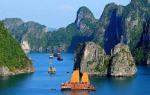
Oceania includes vast areas of the Pacific Ocean - from warm seas located north of the equator to the cold waters of Antarctica. The combined area of Australia and the islands of Oceania is 8.52 million km 2 , with the islands accounting for only 1.26 million km 2 (Figure B.13).
The size and relief of the islands are closely related to their origin. There are continental, volcanic, biogenic and tectonic islands. The latter type arose during the contact of lithospheric plates, so island arcs formed here. Three such arcs can be distinguished on the map of the macroregion. The first arc region consists of the islands of New Guinea, New Caledonia and New Zealand. The second includes the Solomon Islands, the Bismarck Archipelago, the Santa Cruz Islands, Banks and the New Hebrides. The third is formed by the Caroline, Marshall, Gilbert, Tuvalu, Fiji, Tonga and Kermadec islands.
The mainland islands - New Zealand and New Guinea - are the largest in area. Mountain ranges on them are combined with low plains and plateaus. Most of the Pacific islands were formed as a result of violent volcanic activity, which continues to this day. Hawaii is an example of a volcanic island.
Volcanoes that went under water were overgrown with a ring of corals, thus forming atolls - islands of biogenic origin, ring-shaped, inside containing a shallow lagoon. Chains of small islands in the west are the result of tectonic uplifts of bottom sections and are almost parallel to the mountain range in eastern Australia. The relief of islands of this type is a combination of wooded mountains with steep slopes and plains. These are the islands of Fiji and Samoa, as well as New Caledonia, stretched for more than 400 km.
Among the atolls there is also a special type - an elevated atoll, which is a limestone plateau up to 50-60 m above sea level. Islands of this type do not have a lagoon or have traces of its past existence (Nauru, Niue, Banaba). The largest atoll in terms of land area (322 km 2) is Christmas Island (Kiritimati) in the Line Archipelago (Central Polynesian Sporades).
Oceania is located in the equatorial, subequatorial and tropical climatic zones. The only exception is New Zealand with its adjacent island territories, which belong to the subtropical and temperate zones. Most of the islands have a moderately hot climate favorable for human life. Only in the western islands, especially in New Guinea, the air is very hot and humid and there are large temperature differences in the mountains. The air temperature is generally high (+26°С), but the winds from the ocean soften the heat. The ocean equalizes temperature contrasts by seasons and during the day, which contributes to the establishment of even and mild weather conditions.
The climate of the islands of Oceania is mainly determined by the trade winds, so most of them receive a lot of precipitation, on average 3000-4000 mm. They are especially abundant where the mountains of large mainland islands and high volcanic islands. Thus, Hawaii is considered one of the wettest places on Earth, on the windward slopes of volcanoes where up to 12,500 mm of precipitation falls annually. The climate of the islands of Oceania is also greatly influenced by such anomalies as the El Niño and La Niña currents. During El Niño, the intertropical convergence zone moves north, towards the equator; during La Niña, it moves south, away from the equator. In the first case, the islands are heavy rains, in the second - there is a severe drought.
The Pacific Islands have evergreen vegetation. Coconut groves and tropical forests are common. Flora is especially rich western islands mainland origin. The most amazing fauna is also here: tree kangaroo, marsupial anteater, cassowary ostrich, etc. In the forests on the large islands of Melanesia, among many rare animals, there are also anthropoid gibbons. On the coral reefs and sandy beaches you can see turtles, crabs and a variety of sea birds. unique undersea world coral atolls.
The islands of Oceania are traditionally divided into three groups: Melanesia, Polynesia and Micronesia.
Melanesia includes the islands of New Guinea, the Solomons, the New Hebrides, the Bismarck Archipelago, New Caledonia, Fiji, the Santa Cruz Islands, Banks and some other smaller ones. Their indigenous population consists of two large groups- Melanesians (on the coast) and Papuans (in the mountains). In addition to them, pygmy tribes live in inaccessible areas of New Guinea and other large islands. Melanesians from different areas use two languages for interethnic communication. Of these, pidgin English satisfies the needs of 1/4 of the entire population, especially in the northern coastal areas and the highlands of New Guinea, as well as on the islands, becoming the first language for urban children. Hiri-motu is used by the inhabitants of the southern and southeastern coasts of New Guinea. In addition, English is increasingly being used.
The forefather of the independence of Papua New Guinea was N. N. Miklukho-Maclay, a famous Russian ethnographer, traveler and humanist. In 1881, he developed a project for the creation of an independent state - the Papuan Union. His dream came true after less than 100 years: on September 16, 1975, Papua New Guinea was proclaimed an independent state (although the Queen of Great Britain remains its nominal head). The capital of the state and its largest city is Port Moresby with 317,374 inhabitants.
Polynesia (from other Greek "many islands") is located in the central part of the Pacific Ocean, from New Zealand in the south to the Hawaiian Islands in the north. Its extreme point in the east is mysterious island Easter. Compared to the Melanesians, the Polynesians have a lighter skin color and do not have a flattened nose. There is evidence that the Polynesians used their ancient script. They have always been considered unsurpassed navigators and plowed the oceans on amazing ships - double boats with a balancer. Obviously, thanks to this, their language is understood everywhere - from Hawaii to New Zealand and Easter Island.
Micronesia, or "small islands", occupy western part Oceania: the Gilbert Islands, the Marshall Islands, the Caroline and Mariana Islands, Banaba, Nauru, etc. Indonesian influence is great in western Micronesia, and Polynesian influence in eastern Micronesia.
The minerals of Oceania are associated with the origin and geological structure of the islands. Geologically speaking, Oceania is not a continent. Only Australia, New Caledonia, New Zealand, New Guinea and Tasmania, which formed on the site of the hypothetical continent Gondwana, have a continental origin. In the past, these islands were a single land, but as a result of the rise in the level of the World Ocean, a significant part of their surface was under water. The relief of these islands is mountainous and strongly dissected. For example, the highest mountains of Oceania, including Mount Jaya (5029 m), are located on the island of New Guinea.
Most of the islands of Oceania do not have mineral resources in commercial quantities. Nevertheless, on the island of New Caledonia there are deposits of metal ores, including nickel and chromites. Coal, oil, bauxite are mined in New Guinea. On the island of Brugenville (Papua New Guinea) there is one of the world's largest deposits of copper ore containing gold and silver, there is also oil. New Zealand has deposits of natural gas, oil, coal, iron sandstone, gold and silver. In Fiji, deposits of copper, gold and lead are being developed. Separate atolls retain unused phosphorites. The large islands have large reserves of valuable species of tropical timber.
On fig. B. 14 presents the political and geographical structure of the Australia and Oceania supregion.
Today, the politics and economies of the Pacific Islands are undergoing significant changes. A few decades ago, there was only one independent state in this region - New Zealand. Today, politically, Oceania is represented by more than 20 sovereign states. At the same time, the Hawaiian Islands (part of Polynesia) became the 50th US state, and New Zealand (also part of Polynesia) became the most developed state in Oceania, in which 90% of the population are from Europe.
The temperate and humid climate of New Zealand is favorable for the development of agriculture. The country supplies meat, wool, dairy products, grain, timber, as well as high-quality wines to the foreign market. The industry produces textiles, aluminum and plastics.
The standard of living in the country is high. It is characteristic that women here received the right to vote as early as 1893.
New Zealand is located on two islands - North and South. Administrative capital country - Wellington. Most Big city- Auckland (1.3 million inhabitants).
New Zealand is a unitary state based on the principles of a constitutional monarchy and parliamentary democracy (part of the British Commonwealth of Nations). There are two parties in the country - the Labor Party and the National Party.
Some islands and groups of islands still remain overseas colonies of France, the United States, Australia or New Zealand. Others are used as military-strategic bases. Some were used for testing nuclear weapons. However, both the Australian Aborigines and the Maori - the first inhabitants of New Zealand, as well as a number of other indigenous peoples of Oceania, are increasingly asserting their territorial rights. Another important geopolitical circumstance is the weakening of Australia's and New Zealand's traditional trade ties with the UK. Today, both countries successfully conduct intensive trade with Southeast Asia, Japan, China and the United States. Information on the administrative territories of the subregion, its population and capitals is given in Appendix 11.
Most of the states located on the territory of Oceania own a rather poorly developed economic system. This situation is directly related to several reasons. First of all, with limited natural resources, as well as with a significant remoteness from major world markets for the sale of products and a large shortage of highly qualified graduates. Many countries in Oceania are directly dependent on the amount of financial assistance from other powers of the world. The basis of the economy of the vast majority of the states of Oceania is the agricultural sector. First of all, this is the production of palm oil and copra, as well as fishing. Among the most significant crops are bananas, coconut and breadfruit.
The governments of the states located on the territory of Oceania, owning maritime economic zones that are unique in nature and, at the same time, do not have large fishing fleets, are forced to constantly issue licenses for the right to catch fish to ships of foreign states: as a rule, the United States and Japan. The mining industry among all the powers of Oceania is most developed in Papua New Guinea, New Zealand and New Caledonia. A significant part of the population of Oceania is employed in the public sector.
Replenishment of the budget of the countries of the Oceania subregion is traditionally associated with the development of international tourism. However, the magnitude of tourist flows here is much inferior to the main international centers of Western Europe, Southeast Asia and America. Acquaintance with cannibals, deep-sea diving, hunting for dangerous ocean creatures (stingrays, moray eels), surfing among coral reefs and others are successful. extreme views entertainment.
The main tourist destinations are Australia and New Zealand. The limiting factor in their development are:
- 1) the high cost of a flight from almost any region of the world, with the exception of Southeast Asia;
- 2) a rather strict policy for obtaining visas;
- 3) high costs of transport within the country;
- 4) accommodation, although temporary, is much more expensive than in neighboring Asian countries.
The archipelagos of Fiji, French Polynesia, Vanuatu and Easter Island also enjoy relative popularity and prospects for the development of tourism.
1. Area - 8.5 million km. sq., population - 29 million people, 16 sovereign states and 15 dependent territories. Continent + more than 10 thousand islands.
2. Sub-regions - Australia and New Zealand, Micronesia, Melanesia, Polynesia.
I. Australia and New Zealand:
Commonwealth of Australia (Canberra - constitutional omnarchy), New Zealand (Wellington - constitutional monarchy), coconut islands- Keeling (West Island - constitutional omnarchy), Norfolk Island (Kingston - KM), Christmas Island.
2. Micronesia:
Republic of the Marshall Islands (Majuro), Republic of Kiribati (South Tarawa - presidential republic), Nauru (no official capital), Republic of Palau (Ngerulmud), Federated States of Micronesia (Palikir - republic), Guam (Hagatna - US territory), Northern Mariana Islands (Saipan - US territory), Wake Island.
3. Melanesia:
Vanuatu (Port Vila - parliamentary republic), Papua New Guinea (Port Moresby - constitutional monarchy), Solomon Islands (Honiara - KM), Republic of the Fiji Islands (Suva - republic), New Caledonia (Numea).
4.Polynesia:
Independent State of Samoa (Apia - parliamentary republic), Kingdom of Tonga (Nukualofa - KM), Tokelau (Nukunonu - KM), Tuvalu (Funafuti - monarchy), American Samoa (Pago Pago - unorganized territory of the USA), Niue (Alofi - KM) , Cook Islands (Avarua), Easter Island (Hanga Roa), Pitcairn (Adamstown - WB Overseas Territory), Milway, Johnston, Wallis and Futuna (Mata Utu - French Overseas Community), French Polynesia (Papeete - French Overseas Community) .
Features and main stages of the formation of the region:
1. Pre-colonial period.
2. 42,000 and 48,000 years BC - the ancestors of the Australian aborigines appeared in Australia.
3. 30,000 years BC - Aboriginal art.
4. 30-50 thousand years ago - the settlement of about. New Guinea and the nearby islands of Melanesia.
5. 10-12 thousand years BC - Tasmania is isolated from the mainland.
6. About 2-4 thousand years ago, most of Micronesia and Polynesia were settled.
7. By the beginning of the 16th century, the peoples of Oceania were undergoing a period of decay primitive communal system.
Colonial period:
1. 1606 - Willem Janszon discovered Australia.
2. 1606 - The Spanish expedition of Pedro Fernandez Quiroso landed on the New Hebrides.
3. In 1642, the Dutchman Abel Tasman discovered Tasmania and New Zealand.
4. In 1644, Abel Tasman explored the west coast of Australia.
5. By the 50s of the XVII century - a clear map of Australia.
6. From the 16th to the 18th centuries - the period of exploration of Oceania by Europeans.
7. April 19, 1770 - J. Cook landed in Australia.
8. January 26, 1788 - the founding of New South Wales.
9. 1825 - Tasmania (became an independent colony), was settled in 1803.
10. 1828 - Western Australia.
11. 1836 - South Australia.
12. 1851 - Victoria.
13. 1859 - Queensland.
14. In the XVIII - XIX centuries - the division of the islands of Oceania between the colonial powers. From the middle of the 19th century, Australian colonies began to develop as free colonies due to the influx of free people, and not convicts, who were no longer exiled by ships. The development of the region was facilitated by gold mining, which caused a "gold fever".
Decolonization:
1. 1901 - the Commonwealth of Australia is created. Granted the status of a dominion - a self-governing colony.
2. 1907 - New Zealand receives the status of a dominion.
4. 1932 - adoption of the Westminster Statute???
3. 1962 - Western Samoa.
4. 1968 - Nauru.
5. 1970 - Fiji, Tonga.
6. 1975 - Papau New Guinea.
7. 1978 - Solomon's Island, Tuvlau.
8. 1979- Kiribati.
9. 1980 - Vanulau.
10. 1986 - Marshall Islands, Federated States of Micronesia.
11. 1994 - Palau.
Resource base of Australia and Oceania:
Remoteness from economic centers has allowed to preserve significant reserves of minerals.
Coal (No. 3 in the world - after the USA and Russia), oil and gas, iron ore (No. 3 in the world after Brazil and China), Bauxite (No. 1 in the world - Papua New Guinea, No. 2 - Australia), Copper ore , tin (Tasmania Island, Queensland in Australia), nickel, uranium ores (No. 1 in the world - Australia), gold (No. 3 in the world), diamonds, titanium ores, manganese ores, rare earth metals.
+ Natural resources - climate (most of the region is in the tropical zone - Australia is considered the hottest zone in the world - 2/3 of the desert), lack water resources, ocean influence, forest resources (an important factor for future development - Papua New Guinea, New Zealand, Tusmania), endemic (species that are found only in this region) plants and animals, ocean resources.
Population:
1. Australia + New Zealand - the majority of the population are immigrants and their descendants, a fairly small number of natives, the most uneven distribution on the mainland (one of the lowest population densities in the world - 2.4 people per sq. km.). 3/4 of the population of Australia lives on the East Coast. Despite the large territory and low population density, the country is highly urbanized (80% of the urban population) + highly mobile (they change their place of residence very often). Today, immigration is on a limited scale and the bulk of immigrant arrivals in Australia come from Asia.
2. Islands of Oceania - 90% of the population are aboriginal, low standard of living, high birth rate, density fluctuations, literacy problem, religious diversity.
International economic and political organizations:
1. The leader of the region is Australia.
2. ANZUS - military-political associations - Australia, New Zealand, USA.
3. Pacific Islands Forum.
4. Secretariat of the Pacific Community (South Pacific Commission - original name) - 22 states are members. The United States, France, Australia and NZ are in the lead.
5. Pacific Economic Cooperation Council - 26 countries to date.
6 Commonwealth of Nations.
Regional differences - Western Australia, northern territory, Queensland, New South Wales (most developed area), Victoria (most developed area), Tasmania, South Australia.
The problem of the evolution of the region:
1. Rich resource base, as a result, the region plays an important role in the world economy.
2. Less danger of being involved in military conflicts. But in parallel with this, there is a problem from the export of resources.
3. Strong scientific potential in New Zealand and Australia.
4. Powerful potential of recreational resources.
5. Kyoto protocol.
6. Some islands can become an important part of the transport structure of the world - renting out the territory. renting flags.
7. Insurmountable difference in levels of development.
8. Incompleteness of the processes of nation formation.
9. The problem of population development - the problem of poverty, illiteracy, etc.
10. Dependence on the USA. Plus, the interests of China, Japan and France intersect.
Political geography
Australia and Oceania is the largest region in terms of spatial coverage, including the entire Australian mainland and Oceania - an accumulation of about 10 thousand islands in the Pacific Ocean from the Hawaiian Islands in the north to New Zealand in the south. The region is crossed by two subtropical zones, two tropical, two subequatorial, equatorial and in the south - temperate climatic zones. An important feature of the geographical position of the region is its remoteness from other continents and, accordingly, states.
The largest countries in the region are Australian Union And New Zealand. These are economically developed states of resettlement capitalism. All others are developing.
Australia is located on the mainland of the same name, it owns about. Tasmania and a number of small islands, and Australia does not border on any of the states. In 1901, six British colonies were united into the Commonwealth of Australia, which received the status of a dominion. In 1931, Australia received full independence, but is part of the Commonwealth, led by Great Britain. The head of state is the British Queen, who is represented by the Governor General. Therefore, technically, Australia is a constitutional monarchy (unlike Great Britain, Australia has its own constitution). In recent years, the movement for constitutional reform and the acquisition of a republican form of government independent of England has intensified here. Australia is a federal state made up of six states and two territories.
Oceania is the largest cluster of islands and archipelagos. The area of Oceania is 1.26 million km2. The subregion is traditionally divided into three areas - Melanesia (Black Islands), Micronesia (Small Islands) and Polynesia (Many Islands).
The colonial division of the islands was completed by the end of the 19th century. The islands were divided mainly between the UK, France, Spain, and later the US, Germany, Australia and New Zealand. Of particular interest to Europeans was the possibility of creating coconut palm plantations on the islands for the production of copra and sugar cane, as well as the slave trade, which involved recruiting islanders to work on the plantations. The process of disintegration of the colonial system began in the 1960s, but has not yet been completed. Some islands in the region still remain dependent to some extent: New Caledonia, French Polynesia and Wallis and Futuna - from France, the Pitcairn Islands - from Great Britain, the Cook Islands, Niue, Tokelau from New Zealand, a number of islands from the USA.
Melanesia is southwestern part Oceania, a collection of island groups in the Pacific Ocean. The natives do not speak any Polynesian or Micronesian languages, and are also dark-skinned. Area - 940 thousand km 2, most of them belong to the state Papua New Guinea. This is the most developed state, occupying the eastern part of about. New Guinea and a number of small islands. Since 1946, it has been a United Nations trust territory, administered by Australia, and only in 1975 gained independence; the country is a member of the Commonwealth headed by the British Queen, i.e. a constitutional monarchy.
The State has the same status. Solomon islands.
Vanuatu - a republic that is also a member of the Commonwealth but does not recognize the Queen of England as its head of state.
Fiji has a republican form of government and is not part of the Commonwealth.
New Caledonia overseas territory of France. However, since 1989, under pressure from the local population, the direct rule of France was abolished and internal self-government with broad rights was introduced. It was also decided that over the next 15-20 years, the country will undergo a transition, during which government powers will gradually be transferred to local government, and between 2014 and 2018. should pass a referendum on the question of granting the island full independence.
Thus, four independent states have now formed in Melanesia.
Micronesia is the northwestern part of Oceania with with total area 1.8 thousand km 2. There are about 2200 islands here. Since 1947, Micronesia, by decision of the UN, is a UN Trust Territory administered by the United States.
Federated States of Micronesia(FSM), Republic of the Marshall Islands(RMO) and Republic of Palau after the end of the guardianship, the United States became independent states, but "freely associated with the United States." All of them have a republican form of government, and the FSM, as the name implies, has a federal structure.
Kiribati(partially located in Polynesia) and Nauru - republics within the Commonwealth.
In 1978, guardianship over the Mariana Islands was terminated and a new formation appeared on the map - Commonwealth of the Northern Mariana Islands- a commonwealth in political union with the United States, whose residents are US citizens, but do not participate in US presidential elections.
The islands of Micronesia have an important military-strategic position; there are many US military bases here. The Kwajalein Atoll has a testing ground for intercontinental missiles. Of great importance is Fr. Guam in the Mariana Islands group, whose residents are US citizens, but are not eligible to vote in US presidential elections. The island has been granted some rights of local self-government. Guam is the largest US naval base in the Pacific. According to US President R. Reagan, "this is America's flagship in the Western Pacific Ocean, it is within easy reach of any corner of East Asia."
There are five independent states in Micronesia.
Polynesia is located in the central part of the Pacific Ocean and has a shape elongated in the meridional direction. The area of the subregion is 296 thousand km 2, of which 270 thousand are in New Zealand and 17 thousand in the Hawaiian Islands, i.e. all other islands occupy only 9 thousand km 2.
New Zealand located on two large islands and a number of small ones. Previously, it was a British territory, then a dominion of Great Britain, which in 1931 gains independence. Like Australia, New Zealand is part of the Commonwealth; the supreme power in the country formally belongs to the Queen of Great Britain, therefore New Zealand is a parliamentary monarchy (as in England, there is no constitution here). Curiously, New Zealand claims a part of Antarctica, the area of \u200b\u200bwhich is almost twice the area of New Zealand itself.
As for the rest of Polynesia, these are small states.
Samoa - republic, member of the Commonwealth;
Tonga - kingdom, constitutional monarchy within the Commonwealth;
Tuvalu - a constitutional monarchy, since it is part of the Commonwealth and recognizes the head of state of the British Queen.
Still a US possession American Samoa and possession of France - islands of French Polynesia overseas territories with internal self-government.
And finally Hawaiian Islands, which is a US state.
Thus, there are four independent states in Polynesia, and in total there are currently 13 independent states in Oceania; five of them are constitutional (or parliamentary) monarchies, and four of them are quite formal, since they recognize the Queen of Great Britain as the head of state, the rest are republics; according to the administrative-territorial structure - there is only one federation, the rest of the countries are unitary.