The southernmost island of the Kuril ridge. Japan and Russia: who rightfully owns the Kuriles
What is interesting about the Kuril Islands and is it possible to organize a trip on your own? Who owns the Kuriles now: the essence of the Russia-Japan conflict.
The islands of the Sakhalin ridge, bordering Japan, are considered an oriental wonder of nature. Of course, we are talking about the Kuril Islands, whose history is as rich as nature. To begin with, it is worth saying that the struggle for 56 islands located between Kamchatka and Hokkaido began from the moment of discovery.
Kuril Islands on the map of Russia
Kuril Islands - pages of history
So, at the end of the 16th - beginning of the 17th century, when Russian navigators mapped hitherto unexplored lands that turned out to be inhabited, the process of appropriation of uninhabited territories began. At that time, the Kuril Islands were inhabited by a people called Ayans. The Russian authorities tried to attract these people into their citizenship by any means, not excluding force. As a result, the ayans, together with their lands, nevertheless went over to the side of the Russian Empire in exchange for the abolition of taxes.
The situation fundamentally did not suit the Japanese, who had their own views on these territories. Diplomatic methods failed to resolve the conflict. Eventually, according to a document dated 1855, the territory of the islands is considered undivided. The situation became clear only after the end of the Second World War, when amazing territory with a harsh climate was transferred to official ownership.
According to the new world order, the Kuril Islands came under the control of Soviet Union- victorious states. The Japanese, who fought on the side of the Nazis, had no chance.
Who actually owns the Kuril Islands?
Despite the results of the Second World War, which secured the USSR the right to own the Kuril Islands at the world level, Japan still claims the territory. So far, no peace treaty has been signed between the two countries.
What is happening now - in 2019?
Changing tactics Japan is coming compromise and is currently contesting Russia's ownership of only PART of the Kuril Islands. These are Iturup, Kunashir, Shikotan and the Khabomai group. At first glance, this is a small part of the Kuriles, because there are 56 units in the archipelago! One thing is confusing: Iturup, Kunashir, Shikotan are the only Kuril Islands where there is a permanent population (about 18 thousand people). They are located closest to the Japanese "border".
The Japanese and world media, in turn, throw firewood into the firebox of the conflict, exaggerating the topic and convincing ordinary citizens of Japan that the Kuril Islands are vital to them and unfairly captured. When, by whom, at what moment - it does not matter. The main thing is to create as many potential hotbeds of conflict around one vast, but a little unlucky country. Suddenly you're lucky, and somewhere the case will "burn out"?
Representatives of the Russian Federation represented by the President and the Foreign Ministry remain calm. But they do not tire of reminding once again that we are talking about the territory of Russia, which belongs to it by right. Well, in the end, it does not make claims to Poland on Gdansk and - on Alsace and Lorraine 😉
Nature of the Kuril Islands
Not only the history of the development of the islands is interesting, but also their nature. In fact, each of the Kuril Islands is a volcano, and a good part of these volcanoes are currently active. Thanks to volcanic origin, the nature of the islands is so diverse, and the surrounding landscapes are a paradise for photographers and geologists.

Eruption of the Crimean volcano (Kuril Islands, Russia)


locals. Bears of the Kuril Islands.
The Kuril Islands have many geothermal sources, which form whole lakes with hot water rich in healthy micro and macro elements. The Kuril Islands are home to a huge number of animals and birds, many of which are found only in these parts. rich and vegetable world, which is mostly endemic.
Journey to the Kuril Islands 2019
According to its parameters, the territory of the Kuril Islands is perfect for traveling. And even if the climate is harsh, almost no sunny days, high humidity and abundance of precipitation - weather imperfections are covered by the beauty of nature and surprisingly clean air. So if you are worried about the weather on the Kuril Islands, then you can survive it.

Briefly, the history of the "belonging" of the Kuril Islands and Sakhalin Island is as follows.
1.In period 1639-1649. Russian Cossack detachments led by Moskovitinov, Kolobov, Popov explored and began to explore Sakhalin and the Kuril Islands. At the same time, Russian pioneers repeatedly swim to the island of Hokkaido, where they are peacefully met by local natives of the Ainu people. The Japanese appeared on this island a century later, after which they exterminated and partially assimilated the Ainu.
2.B 1701 Cossack constable Vladimir Atlasov reported to Peter I about the "subordination" of Sakhalin and the Kuril Islands to the Russian crown, leading to the "wonderful Nipon kingdom."
3.B 1786. By order of Catherine II, a register of Russian possessions in the Pacific Ocean was produced, bringing the register to the attention of all European states as a declaration of Russia's rights to these possessions, including Sakhalin and the Kuriles.
4.B 1792. By decree of Catherine II, the entire ridge of the Kuril Islands (both Northern and Southern), as well as Sakhalin Island officially included in Russian Empire.
5. As a result of the defeat of Russia in the Crimean War 1854—1855 gg. under pressure England and France Russia forced was concluded with Japan on February 7, 1855. Treaty of Shimoda, through which four southern islands of the Kuril chain were transferred to Japan: Habomai, Shikotan, Kunashir and Iturup. Sakhalin remained undivided between Russia and Japan. At the same time, however, the right of Russian ships to enter Japanese ports was recognized, and "permanent peace and sincere friendship between Japan and Russia" was proclaimed.
6.May 7, 1875 under the Petersburg Treaty, the tsarist government as a very strange act of "good will" makes incomprehensible further territorial concessions to Japan and transfers to it 18 more small islands of the archipelago. In return, Japan finally recognized Russia's right to the whole of Sakhalin. It is for this agreement referred most of all by the Japanese today, slyly silent that the first article of this treaty reads: "... and henceforth eternal peace and friendship will be established between Russia and Japan" ( the Japanese themselves violated this treaty in the 20th century repeatedly). Many Russian statesmen of those years sharply condemned this “exchange” treaty as short-sighted and harmful to the future of Russia, comparing it with the same short-sightedness as the sale of Alaska to the United States of America in 1867 for next to nothing (7 billion 200 million dollars). ), saying that "now we are biting our own elbows."
7. After the Russo-Japanese War 1904—1905 gg. followed another stage of humiliation of Russia. By Portsmouth peace treaty concluded on September 5, 1905, Japan received southern part Sakhalin, all the Kuril Islands, and also took away from Russia the right to lease the naval bases of Port Arthur and Dalniy. When Russian diplomats reminded the Japanese that all these provisions are contrary to the 1875 treaty g., those arrogantly and arrogantly answered : « War cancels all treaties. You have failed and let's proceed from the current situation ". Reader, remember this boastful declaration of the invader!
8. Next comes the time of punishment of the aggressor for his eternal greed and territorial expansion. Signed by Stalin and Roosevelt at the Yalta Conference February 10, 1945 G. " Agreement on the Far East"It was envisaged:" ... 2-3 months after the surrender of Germany, the Soviet Union will enter the war against Japan subject to the return to the Soviet Union of the southern part of Sakhalin, all the Kuril Islands, as well as the restoration of the lease of Port Arthur and Dalny(these built and equipped hands of Russian workers, soldiers and sailors back in the late XIX - early XX centuries. very comfortable on their own geographic location naval bases were donated to "fraternal" China. But these bases were so necessary for our fleet in the 60-80s of revelry " cold war"and intense combat service of the fleet in remote areas of the Pacific and Indian Oceans. I had to equip the forward base Cam Ranh in Vietnam for the fleet from scratch).
9.B July 1945 g. in accordance with Potsdam Declaration heads of the victorious countries the following verdict was passed regarding the future of Japan: "The sovereignty of Japan shall be limited to four islands: Hokkaido, Kyushu, Shikoku, Honshu, and such as WE SPECIFY". August 14, 1945 the Japanese government has publicly confirmed the acceptance of the terms of the Potsdam Declaration, and on September 2 Japan unconditionally surrendered. Article 6 of the Instrument of Surrender reads: "... the Japanese government and its successors will faithfully fulfill the terms of the Potsdam Declaration to give such orders and take such actions as the Commander-in-Chief of the Allied Powers shall require in order to carry out this declaration...”. January 29, 1946 Commander-in-Chief General MacArthur DEMANDED by Directive No. 677: "The Kuril Islands, including Habomai and Shikotan, are excluded from the jurisdiction of Japan." AND only after that legal action, a Decree of the Presidium was issued Supreme Council USSR dated February 2, 1946, which read: “ All lands, bowels and waters of Sakhalin and the Kul Islands are the property of the Union of Soviet Socialist Republics ". Thus, the Kuril Islands (both Northern and Southern), as well as about. Sakhalin, legally And in accordance with the regulations international law were returned to Russia . This could put an end to the "problem" of the Southern Kuriles and stop all further verbiage. But the story of the Kuriles continues.
10. After the end of World War II US occupied Japan and turned it into their military foothold in the Far East. In September 1951 USA, UK and a number of other states (total 49) signed San Francisco Peace Treaty with Japan, prepared in violation of the Potsdam agreements without the participation of the Soviet Union . Therefore, our government did not join the treaty. However, Art. 2, chapter II of this treaty, it is fixed in black and white: “ Japan renounces all legal grounds and claims ... to the Kuril Islands and that part of Sakhalin and the islands adjacent to it over which Japan acquired sovereignty under the Treaty of Portsmouth of September 5, 1905. However, even after this, the story with the Kuriles does not end.
October 11.19 1956 d. the government of the Soviet Union, following the principles of friendship with neighboring states, signed with the Japanese government joint declaration, according to which the state of war between the USSR and Japan ended and peace, good neighborliness and friendly relations were restored between them. When signing the Declaration as a gesture of good will and no more promised to give Japan the two southernmost islands of Shikotan and Habomai, but only after the conclusion of a peace treaty between the countries.
12. However The United States after 1956 imposed a number of military agreements on Japan, replaced in 1960 by a single "Treaty of Mutual Cooperation and Security", according to which US troops remained on its territory, and thereby the Japanese islands turned into a base of aggression against the Soviet Union. In connection with this situation, the Soviet government announced to Japan that it was impossible to transfer the promised two islands to it.. And in the same statement it was emphasized that according to the declaration of October 19, 1956, "peace, good neighborliness and friendly relations" between the countries were established. Therefore, an additional peace treaty may not be required.
Thus, the problem of the Southern Kuriles does not exist
. It's been decided a long time ago. AND de jure and de facto the islands belong to Russia
. In this regard, it might be to remind the Japanese of their arrogant statement in 1905 g., and also indicate that Japan was defeated in World War II and therefore has no rights to any territory, even to her ancestral lands, except for those granted to her by the victors.
AND our foreign ministry just as harshly, or in a milder diplomatic form it would be necessary to declare this to the Japanese and put an end to this, FOREVER stopping all negotiations
and even conversations on this non-existent and humiliating problem of the dignity and authority of Russia.
And again the "territorial question"
However, starting from 1991
, repeatedly held meetings of the President Yeltsin and members of the Russian government, diplomats with government circles in Japan, during which the Japanese side every time importunately raises the question of the "Northern Japanese Territories".
Thus, in the Tokyo Declaration 1993
signed by the President of Russia and the Prime Minister of Japan, was again acknowledged the "existence of the territorial issue", and both sides promised to "make efforts" to resolve it. The question arises - could our diplomats really know that such declarations should not be signed, because the recognition of the existence of a “territorial issue” is contrary to the national interests of Russia (Article 275 of the Criminal Code of the Russian Federation “ Treason»)??
As for the peace treaty with Japan, it is de facto and de jure in accordance with the Soviet-Japanese Declaration of October 19, 1956. not really needed. The Japanese do not want to conclude an additional official peace treaty, and there is no need. He Japan needs more, as the side that was defeated in the Second World War, rather than Russia.
A citizens of Russia should know the “problem” of the South Kuriles, sucked from the finger , her exaggeration, periodic hype in the media around her and the litigation of the Japanese - there a consequence of Japan's illegitimate claims in violation of the obligations it has assumed, to strictly comply with the international obligations recognized and signed by it. And such a constant desire of Japan to reconsider the ownership of many territories in the Asia-Pacific region pervades Japanese politics throughout the 20th century.
Why the Japanese, one might say, have seized the South Kuriles with their teeth and are trying to seize them again illegally? But because the economic and military-strategic importance of this region is extremely great for Japan, and even more so for Russia. This an area of colossal seafood riches(fish, living creatures, marine animals, vegetation, etc.), deposits of minerals, and rare earth minerals, energy sources, mineral raw materials.
For example, January 29 of this year. short information slipped through the Vesti (RTR) program: a a large deposit of the rare earth metal Rhenium(75th element in the periodic table, and the only one in the world
).
Scientists allegedly calculated that it would be enough to invest only 35 thousand dollars, but the profit from the extraction of this metal will allow to bring the whole of Russia out of the crisis in 3-4 years
. Apparently the Japanese know about this and therefore attack so persistently Russian government demanding to give them the islands.
It must be said that for 50 years of ownership of the islands, the Japanese have not built or created anything capital on them, except for light temporary buildings. Our border guards had to rebuild barracks and other buildings at the outposts. The entire economic "development" of the islands, which the Japanese are shouting to the whole world today, consisted in the predatory robbery of the riches of the islands . During the Japanese "development" from the islands rookeries of fur seals, habitats of sea otters disappeared . Part of the population of these animals our Kuril residents have already restored .
Today, the economic situation of this entire island zone, like the whole of Russia, is difficult. Of course, significant measures are needed to support this region and take care of the Kuril people. According to the calculations of a group of deputies of the State Duma, it is possible to extract on the islands, as reported in the program "Parliamentary Hour" (RTR) on January 31 of this year, only fish products up to 2000 tons per year, with a net profit of about 3 billion dollars.
In military terms, the ridge of the Northern and Southern Kuriles with Sakhalin constitutes a complete closed infrastructure of the strategic defense of the Far East and the Pacific Fleet. They enclose the Sea of Okhotsk and turn it into an inland one. This is the area deployment and combat positions of our strategic submarines.
Without the South Kuriles, we will get a "hole" in this defense. Control over the Kuriles ensures free access of the fleet to the ocean, because until 1945 our Pacific Fleet, starting from 1905, was practically locked up in its bases in Primorye. The means of detection on the islands provide long-range detection of air and surface enemy, the organization of anti-submarine defense of the approaches to the passages between the islands.
In conclusion, one should note such a feature in the relationship of the Russia-Japan-US triangle. It is the United States that confirms the "legitimacy" of the ownership of the islands of Japan
in spite of all international treaties they have signed
.
If so, then our Foreign Ministry has full right in response to the claims of the Japanese to invite them to demand the return of Japan to her " southern territories"- Caroline, Marshall and Mariana Islands.
These archipelagos former colonies Germany, captured by Japan in 1914. Japan's dominion over these islands was sanctioned by the 1919 Treaty of Versailles. After the defeat of Japan, all these archipelagos came under US control.. So Why shouldn't Japan demand that the United States return the islands to her? Or lack of spirit?
As you can see, there is clear double standard foreign policy Japan.
And one more fact that clarifies the general picture of the return of our Far Eastern territories in September 1945 and military value this region. The Kuril operation of the 2nd Far Eastern Front and the Pacific Fleet (August 18 - September 1, 1945) provided for the liberation of all the Kuril Islands and the capture of the island of Hokkaido.
The accession of this island to Russia would be of great operational and strategic importance, since complete isolation of the "fence" would be ensured Sea of Okhotsk our island territories: Kuriles - Hokkaido - Sakhalin. But Stalin canceled this part of the operation, saying that with the liberation of the Kuriles and Sakhalin, we had resolved all our territorial issues in the Far East. A we don't need foreign land . In addition, the capture of Hokkaido will cost us a lot of blood, unnecessary losses of sailors and paratroopers in the very last days of the war.
Stalin here showed himself to be a real statesman, taking care of the country, its soldiers, and not an invader, who coveted foreign territories that were very accessible in that situation for the capture.
Since 1945, the authorities of Russia and Japan have not been able to sign a peace treaty because of a dispute over the ownership of the southern part of the Kuril Islands.
The Northern Territories Issue (北方領土問題 Hoppo: ryō:do mondai) is a territorial dispute between Japan and Russia that Japan considers unresolved since the end of World War II. After the war, all the Kuril Islands came under the administrative control of the USSR, but a number of the southern islands - Iturup, Kunashir and the Lesser Kuril Ridge - are disputed by Japan.
In Russia disputed territories are part of the Kuril and Yuzhno-Kuril urban districts of the Sakhalin Region. Japan claims four islands in the southern part of the Kuril chain - Iturup, Kunashir, Shikotan and Habomai, referring to the bilateral Treaty on Trade and Borders of 1855. Moscow's position is that southern Kuriles became part of the USSR (of which Russia became the successor) following the results of the Second World War, and Russian sovereignty over them, having the appropriate international legal design, is beyond doubt.
The problem of ownership of the southern Kuril Islands is the main obstacle to the complete settlement of Russian-Japanese relations.
Iturup(Jap. 択捉島 Etorofu) is an island of the southern group of the Great Ridge of the Kuril Islands, the largest island of the archipelago.
Kunashir(Ainu Black Island, Japanese 国後島 Kunashiri-to :) - the most south island Large ridge of the Kuril Islands.
Shikotan(jap. 色丹島 Sikotan-to:?, in early sources Sikotan; name from the Ainu language: "shi" - large, significant; "kotan" - village, city) - the largest island small ridge Kuril Islands.
Habomai(Jap. 歯舞群島 Habomai-gunto ?, Suisho, "Flat Islands") - Japanese name island groups in the northwest Pacific Ocean, together with the island of Shikotan in Soviet and Russian cartography, considered as the Lesser Kuril Ridge. The Habomai group includes the islands of Polonsky, Oskolki, Zeleny, Tanfiliev, Yuri, Demin, Anuchin and a number of small ones. Separated by the Soviet Strait from the island of Hokkaido.
History of the Kuril Islands
17th century
Before the arrival of the Russians and the Japanese, the islands were inhabited by the Ainu. In their language, “kuru” meant “a person who came from nowhere,” from which their second name “smokers” came from, and then the name of the archipelago.
In Russia, the first mention of the Kuril Islands dates back to 1646, when N. I. Kolobov spoke about the bearded people inhabiting the islands Ainakh.
The Japanese first received information about the islands during an expedition [source not specified 238 days] to Hokkaido in 1635. It is not known whether she actually got to the Kuriles or learned about them indirectly, but in 1644 a map was drawn up on which they were designated under the collective name "thousand islands". Candidate of Geographical Sciences T. Adashova notes that the map of 1635 "is considered by many scientists to be very approximate and even incorrect." Then, in 1643, the islands were surveyed by the Dutch, led by Martin Fries. This expedition made more detailed maps and described the lands.
18th century
In 1711, Ivan Kozyrevsky went to the Kuriles. He visited only 2 northern islands: Shumshu and Paramushir, but he asked in detail the Ainu and Japanese who inhabited them and the Japanese brought there by a storm. In 1719, Peter I sent an expedition to Kamchatka led by Ivan Evreinov and Fyodor Luzhin, which reached Simushir Island in the south.
In 1738-1739, Martyn Spanberg walked along the entire ridge, putting the islands he met on the map. In the future, the Russians, avoiding dangerous voyages to the southern islands, mastered the northern ones, taxed the local population with yasak. From those who did not want to pay it and went to distant islands, they took amanats - hostages from among close relatives. But soon, in 1766, the centurion Ivan Cherny from Kamchatka was sent to the southern islands. He was ordered to attract the Ainu into citizenship without the use of violence and threats. However, he did not follow this decree, mocked them, poached. All this led to a rebellion of the indigenous population in 1771, during which many Russians were killed.
Great success was achieved by the Siberian nobleman Antipov with the Irkutsk translator Shabalin. They managed to win the favor of the Kuril people, and in 1778-1779 they managed to bring into citizenship more than 1500 people from Iturup, Kunashir and even Matsumaya (now Japanese Hokkaido). In the same 1779, Catherine II by decree freed those who accepted Russian citizenship from all taxes. But relations were not built with the Japanese: they forbade the Russians to go to these three islands.
In "Extensive Land Description Russian state... "In 1787, a list was given from the 21st island, owned by Russia. It included islands up to Matsumaya (Hokkaido), whose status was not clearly defined, since Japan had a city in its southern part. At the same time, the Russians had no real control even over the islands south of Urup. There, the Japanese considered the Kurilians their subjects, actively used violence against them, which caused discontent. In May 1788, a Japanese merchant ship that had come to Matsumai was attacked. In 1799, by order of the central government of Japan, two outposts were founded on Kunashir and Iturup, and guards began to be constantly guarded.
19th century
In 1805, a representative of the Russian-American Company, Nikolai Rezanov, who arrived in Nagasaki as the first Russian envoy, tried to resume negotiations on trade with Japan. But he also failed. However, the Japanese officials, who were not satisfied with the despotic policy of the supreme power, gave him hints that it would be nice to carry out a forceful action in these lands, which could push the situation off the ground. This was carried out on behalf of Rezanov in 1806-1807 by an expedition of two ships led by Lieutenant Khvostov and midshipman Davydov. Ships were plundered, a number of trading posts were destroyed, and a Japanese village was burned on Iturup. Later they were tried, but the attack for a while led to a serious deterioration Russo-Japanese relations. In particular, this was the reason for the arrest of Vasily Golovnin's expedition.
In exchange for the right to own southern Sakhalin, Russia transferred to Japan in 1875 all the Kuril Islands.
20th century
After the defeat in 1905 in the Russo-Japanese War, Russia transferred the southern part of Sakhalin to Japan.
In February 1945, the Soviet Union promised the United States and Great Britain to start a war with Japan on the condition that Sakhalin and the Kuril Islands be returned to it.
February 2, 1946. Decree of the Presidium of the Supreme Soviet of the USSR on the inclusion of South Sakhalin and the Kuril Islands in the RSFSR.
1947. Deportation of Japanese and Ainu from the islands to Japan. Displaced 17,000 Japanese and an unknown number of Ainu.
November 5, 1952. A powerful tsunami hit the entire coast of the Kuriles, Paramushir suffered the most. A giant wave washed away the city of Severo-Kurilsk (formerly Kasivabara). The press was forbidden to mention this catastrophe.
In 1956, the Soviet Union and Japan agreed to a Joint Treaty formally ending the war between the two states and ceding Habomai and Shikotan to Japan. Signing the treaty, however, failed: the United States threatened not to give Japan the island of Okinawa if Tokyo renounces its claims to Iturup and Kunashir.
Maps of the Kuril Islands
The Kuril Islands on an English map of 1893. Plans of the Kuril Islands, from sketches chiefly mand by Mr. H. J. Snow, 1893. (London, Royal Geographical Society, 1897, 54×74 cm)
Map fragment Japan and Korea - Location of Japan in the Western Pacific (1:30,000,000), 1945


Photomap of the Kuril Islands based on space image NASA, April 2010.
List of all islands
View of Habomai from Hokkaido
Green Island (志発島 Shibotsu-to)
Polonsky Island (Jap. 多楽島 Taraku-to)
Tanfiliev Island (Jap. 水晶島 Suisho-jima)
Yuri Island (勇留島 Yuri-to)
Anuchina Island
Demina Islands (Japanese: 春苅島 Harukari-to)
Shard Islands
Kira Rock
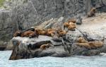
Rock Cave (Kanakuso) - a rookery of sea lions on a rock.
Sail Rock (Hokoki)
Candle Rock (Rosoku)
Fox Islands (Todo)
Bump Islands (Kabuto)
Can Dangerous
Watchtower Island (Homosiri or Muika)
Drying Rock (Odoke)
Reef Island (Amagi-sho)
Signal Island (Jap. 貝殻島 Kaigara-jima)
Amazing Rock (Hanare)
Seagull Rock
On the border of the Pacific Ocean and its Sea of Okhotsk, located between the island of Hokkaido (Japan) and the Kamchatka Peninsula; territory of Russia (Sakhalin region). It includes more than 30 relatively large islands, many small islands and separate rocks. The total area is 15.6 thousand km. It consists of two parallel ridges of islands (representing the tops of powerful underwater ridges) - the Great Kuril Ridge, stretched for 1200 km, and bordering its southern tip from the east of the Lesser Kuril Ridge (120 km), separated by the South Kuril Strait. The northern continuation of the Lesser Kuril Ridge is the underwater Vityaz Ridge. The Kuril Islands are separated by the Kuril Straits. The deep straits - Kruzenshtern and Bussol divide the Great Ridge into 3 groups of islands: the northern one (the islands of Shumshu, Atlasova, Paramushir, Makanrushi, Avos, Onekotan, Kharimkotan, Chirinkotan, Ekarma, Shiashkotan, a group of rocks of the Trap), the middle one (the islands of Raikoke, Matua, Rasshua , groups of islands of the Middle and Ushishir, Ketoi, Simushir) and southern (Broughton Islands, Black Brothers, Urup, Iturup - the largest of the Kuril Islands, Kunashir). The Lesser Kuril Ridge includes 6 islands (Shikotan, Polonsky, Zeleny, Yuri, Anuchin, Tanfilyev) and 2 groups of rocks. The shores of the Kuril Islands are mostly steep or terraced, on the isthmuses - low sandy. There are few well-hidden bays.
Relief and geological structure. The Kuril Islands are dominated by low and medium mountain relief (altitude from 500 to 1300 m, maximum - 2339 m, Alaid volcano). Near the top of this volcano there is a small glacier, unique for the Kuril Islands. Only Shumshu Island and most of the islands of the Lesser Kuril Ridge are plain (up to 412 m high on Shikotan Island). In total, there are over 100 terrestrial volcanoes on the Kuril Islands, of which about 30 are classified as active. The most active volcanoes are Alaid (over the past 200 years, 9 eruptions), Sarychev volcano, Fussa. Less active are: Severgina volcano, Sinarka, Raikoke, Curly, Ebeko, Nemo, Kuntomintar, Ekarma, Pallas, Mendeleev volcano. There are 5 main morphogenetic types of relief: terrestrial volcanic, erosion-denudation, marine (abrasive and accumulative), seismotectonic and eolian. Most of the islands have a volcanic terrestrial relief with single volcanic cones, volcanic ridges and massifs connected by reclaimed isthmuses. In the coastal part of the islands, 6-7 levels of marine terraces are distinguished (height from 2-3 m to 200 m). Volcanic massifs and sea terraces are dissected and dissected by erosion-denudation processes, the intensity and depth of which depend on the duration of the stage of land development. Eolian and seismotectonic relief types on the islands are of subordinate importance. In the middle and late Pleistocene, the Kuril Islands underwent two glaciations. It is assumed that during the periods of maximum development of glaciations, when the level of the World Ocean dropped significantly, the Paramushir and Shumshu islands formed a single whole with Kamchatka, and Kunashir and the islands of the Lesser Kuril Ridge were connected with Sakhalin, Hokkaido and the mainland.
The Kuril Islands are a typical island-arc volcanic belt that formed above the underthrust (subduction) zone of the Pacific lithospheric plate in the Kuril-Kamchatsky deep sea trench. The Greater Kuril Ridge is composed of a complex of Oligocene-Quaternary volcanic and volcanic-detrital rocks (composition from basalts to rhyolites with a predominance of andesites). The Lesser Kuril Ridge is formed mainly by Upper Cretaceous and Paleocene volcanic-clastic rocks of basaltic andesite composition of underwater origin, which are weakly deformed and overlain by Pliocene-Quaternary ground lavas. Modern terrestrial volcanism is manifested only on the Great Kuril Ridge. The Kuril Islands and the adjacent part of the Pacific Ocean floor is a zone of intense seismicity and high tsunami hazard. Strong earthquakes occurred in 1958 (magnitude 8.3; caused a tsunami), 1963 (8.5), 2002 (7.3), 2006 (8.3), 2007 (8.1), 2009 (7.4). Sulfur deposits are known (New on the island of Iturup), thermal waters, ore occurrences of mercury, copper, tin, and gold.
Climate. On the Kuril Islands, the climate is temperate maritime, cold. It is mainly influenced by baric systems that form over the cold waters of the northern part of the Pacific Ocean, the Sea of Okhotsk, and the cold Kuril Current. Over the southern group of islands, the features of the monsoon circulation of the atmosphere are manifested in a weakened form, in particular, the action of the winter Asian anticyclone. The heat supply of the landscapes of the Kuril Islands is two to three times lower than at the corresponding latitudes in the central part of the mainland. The average winter temperatures on all the islands are approximately the same and range from -5 to -7°C. During the winter, thaws, prolonged heavy snowfalls and blizzards, and constant cloudiness are often observed. Summer temperatures vary from 16°C in the south to 10°C in the north. One of the main factors determining summer temperatures is the nature of the hydrological circulation in coastal waters. Near the islands of the northern and middle groups, even in August, the temperature of coastal waters does not exceed 5-6 ° C, therefore, these islands are characterized by the lowest summer air temperatures in the Northern Hemisphere (at the corresponding latitudes). During the year, up to 1000-1400 mm of precipitation falls on the islands, relatively evenly distributed over the seasons. Humidification is excessive everywhere; in the south, precipitation exceeds evaporation by almost 400 mm. The average monthly air humidity in the second half of summer reaches 90-97%, which causes frequent dense fogs. At the same time, the Kuril Islands are under the influence of tropical cyclones (sometimes typhoons), accompanied by heavy rainfall.
surface water. On major islands there are many rivers and streams, which is explained by a significant amount of precipitation, high air humidity, and the mountainous nature of the relief, which contributes to vigorous runoff and the formation of valleys. The water in some streams is mineralized. Often there are mineralized springs of different temperatures. Small islands-volcanoes are often waterless. There are many small lakes, including volcanic (crater, solfataric, lava-dammed), lagoonal, oxbow lakes, etc. The low flat islands of the Lesser Kuril Ridge are heavily swamped.
Landscape types. Characteristic landscapes of the Kuril Islands - a small number of dominant species in phytocenoses. In total, 1367 species of plants were found in the flora, but no more than 100 species are widespread, and there are no more than 20 species of plants that create the main background in landscapes. Soils on the islands are predominantly volcanic, soddy and alluvial, under forests - slightly podzolic. The significant length of the island ridge from north to south determines the allocation within it of several landscape zones associated with different heat supply.
IN northern group The islands are formed by elfin-tundra landscapes, the harsh climate determines their rather simple structure. The lower parts of the slopes are occupied by impenetrable thickets of alder and elfin pine, above 300-400 m they are replaced by heath tundra of small low shrubs (suksha, alpine bearberry, blueberry, golden rhododendron, etc.), on the top surfaces of volcanic ridges among the rocks are fragments of mountain tundra communities. The exception is the heavily swamped island of Shumshu. Most of the islands of the middle group are located in the zone of distribution of stone birch forests. Stone birch is the only tree species that can withstand harsh climatic conditions this part of the Kuril Islands.
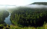
The southern group of islands belongs to the zone of mixed coniferous-deciduous forests. The forest cover of Iturup Island is 80%, Kunashir Islands - 61%. A warmer climate causes the formation of unusual vegetation here: the first tier is formed by dark coniferous species (Sakhalin fir and Ayan spruce), the second is thermophilic broad-leaved species (oaks, elms, ash, dimorphant, etc.), the undergrowth is formed by dense thickets of subtropical bamboo. On the island of Kunashir, even magnolia and velvet trees have been found in such forests. A similar combination is found on Earth only on a few islands in the North Pacific Ocean. Landscapes of broad-leaved and mixed forests usually occupy the lower parts of the slopes of volcanic ridges (up to 400 m), above - dark coniferous spruce-fir taiga, first replaced by stone-birch forests, then - elfin and heath tundra. On the tops of volcanoes (altitude over 1000 m) sparse vegetation of chars with numerous rocky outcrops prevails. Grass-forb meadows and thickets of bamboo are common on sea terraces. Along the river valleys, in the lower parts of the slopes, where the soils are provided with nutrients and moisture, thickets of large grasses are characteristic, consisting of Sakhalin buckwheat, shelomaynik, bear angelica, etc. 4 meters high.
 The landscapes of the coast of the Sea of Okhotsk of the southern group of islands are much richer in biodiversity than the landscapes of the Pacific coast. This is due to the warming effect of the Soya current, which significantly softens the climate of the west coast.
State environment and protected natural areas. The nature of the Kuril Islands as a whole is slightly changed. Modern anthropogenic disturbances are localized near a few settlements. There are old developments of minerals (sulfur, etc.). Most of the islands have no permanent population.
The uniqueness of the island nature (overlapping areas of boreal and subtropical species of flora and fauna, large concentrations of marine mammals and colonial birds, active volcano ism) led to a fairly developed network of protected natural areas. Organized Kuril Reserve, the federal reserve Small Kuriles, the regional reserves Ostrovnoy (Iturup Island) and Kraternaya Bay (Yankich Island in middle group islands); 15 regional and local natural monuments. Big cities- Severo-Kurilsk, Kurilsk.
Lit .: Southern Kuril Islands. Yuzhno-Sakhalinsk, 1992; Flora and fauna of the Kuril Islands. Vladivostok, 2002; Reference book physical geography Sakhalin region. Yuzhno-Sakhalinsk, 2003; Atlas of the Kuril Islands. M.; Vladivostok, 2009.
On February 2, 1946, Mikhail Kalinin, Chairman of the Presidium of the Supreme Soviet of the USSR, signed a decree according to which South Sakhalin and the Kuril Islands became part of the Soviet Union. The country received a territory that is rightfully considered one of the most scenic spots Earth. amazing scenery, active volcanoes Plants and animals found only here make the Kuriles attractive for tourists and researchers.
The Kuriles are a chain of 56 islands, from Kamchatka to the island of Hokkaido, which includes two parallel ridges - the Greater and Lesser Kuril Islands. They separate the Sea of Okhotsk from the Pacific Ocean. Local natives - the Ainu - are still a mystery to scientists who disagree on where this people came from.
It is known that the Ainu lived in the Kuriles for at least seven thousand years. They had very thick hair; men wore long beards and mustaches (in contrast to the representatives of the Mongoloid race, who were deprived of facial hair). Their body was also hairy, which is why some scientists assumed that the ancestors of the Ainu were from the Caucasus. However, DNA tests did not confirm this hypothesis: rather, relatives of the Kuril natives lived in Tibet and Andaman Islands in the Indian Ocean.
The facial features of the natives resembled those of Europe. They didn't look like theirs appearance, language and customs neither on Kamchadals, nor on the Japanese. Despite the by no means hot climate, in the summer the Ainu wore only loincloths, like residents of hot latitudes. They were engaged in agriculture, hunting, fishing, gathering.
The Ainu gave names to the islands: Paramushir meant "wide island", Ushishir - "island with bays", Shikotan - "the best place", Kunashir - "black island". "Man" in their language sounded like "kuru". That is why the Cossacks from the first Russian expeditions that arrived on the islands called the natives smokers and smokers.

Here, courageous men work at sea, and beautiful women are waiting for them on the islands, driving off-road in huge Japanese jeeps, more like one-room Stalin apartments than cars. Here, the harsh life of sailors is full of romance, and romance becomes commonplace. Here, anyone who has lived more than a year on land considers himself a local resident.
Everything you need, including food, is delivered to the islands from Vladivostok, and not from the nearest Sakhalin, because Sakhalin is also an island, and everything is also expensive.

There is nothing on the Kuril Islands except for "dilapidated housing", fish factories and border troops of the FSB. Here, the "continental man" is always haunted by only two smells - fish and the sea, and only two obsessive sounds - the cry of seagulls and the breath of the ocean.
And yet, the Kuriles are one of the most, perhaps, picturesque islands Russia.
highest waterfall

The waterfall, which for a long time was considered the highest in Russia, is located on the island of Iturup. The height of the "hero" is 141 meters - about the same as a 40-story building. The name of the epic hero was given to the waterfall in 1946 by the participants of the Sakhalin research expedition.
Ilya Muromets is three times higher than the free fall of water (not interrupted by ledges) Niagara Falls and is considered the most inaccessible waterfall in the Far East. It can be seen without risk to life only from the side of the water - from the side of a sea vessel or a low-flying aircraft. Although they say that trained climbers, with special equipment, reached him on the ground, through high crumbling cliffs.
The largest island

Iturup is considered the largest island of the Kuril Islands, with an area of 3200 square kilometers. This is slightly larger than the Pacific island nation of Samoa. In the Ainu language, "etorop" means "jellyfish"; there is also a version that the name of the island is associated with the neighboring island of Urup ("salmon"). On Iturup is the city of Kurilsk, where more than 2600 people live.
The nature here is contrasting: spruce-fir forests, thickets of bamboo, elfin. The picturesque landscape is decorated with 20 volcanoes, nine of which are active. Highest, dormant volcano Stockap, has a height of 1634 meters and consists of ten merged cones with several craters on top. The island is rich in lakes (more than 30), hot and mineral springs.
The most unusual lake

Boiling Lake Ponto is located in the south of Lake Kunashir, at an altitude of 130 meters above sea level. It is located in the caldera of the Golovnin volcano. This dangerous place: the lake seethes, boils, jets of gas and steam periodically break out near the shores. Ponto has a depth of up to 23 meters, its diameter is about 230 meters. Surface temperature at exit points thermal waters, reaches 100 degrees, and in other parts - up to 60 degrees.
The color of the water in Ponto is lead-gray - due to lake sediments, which are saturated with sulfur (there is evidence that the Japanese mined it here at the beginning of the last century). The water of the lake contains a large amount of antimony, arsenic, salts of heavy metals. Near the boiling lake, there is Lake Hot, where you can swim. Its water is turquoise. The two lakes are separated by a rock, but they communicate with each other through an artificial channel dug by the Japanese.
Tallest active volcano

The northernmost and highest volcano of the Kuriles - Alaid - is located 30 kilometers northwest of Paramushir Island and 70 kilometers southwest of Kamchatka. Its height is 2339 meters. There is a legend that Alaid used to be located in the south of Kamchatka, but other mountains expelled it: due to the fact that it was the largest, the volcano obscured the light. Since then, Alaid has been standing alone - on Atlasov Island in the Sea of Okhotsk. And on the Kuril Lake in Kamchatka, the island of the Heart of Alaid remained.
The volcano has 33 secondary cinder cones on the slopes and at the base. Since the end of the 18th century, it has erupted more than a dozen times. IN last time this happened on August 23, 1997. In addition, small seismic activity was recorded from October 31 to December 19, 2003. And on October 5, 2012, Alaid threw steam and gas plumes to a height of 200 meters.
There is a sad page in the history of the volcano: in April 2002, two Japanese tourists died while climbing Alaid.
most active volcano

The most active volcano from the Kuril group is located on the island of Matua of the Great Kuril Ridge. It got its name in honor of the Russian navigator and hydrographer Gavriil Sarychev. The height of the volcano is 1446 meters above sea level.
Only in the last century, the Sarychev volcano erupted seven times. One of the most powerful eruptions was recorded in 1946: then a stream of a mixture of volcanic gases, ash and stones reached the sea. The last time the volcano erupted in 2009, this led to an increase in the island's area by 1.5 square kilometers.
The most unusual volcano

Volcano Tyatya, located on the Kunashir Island of the Great Kuril Ridge, is considered one of the most beautiful on the planet. This is a "volcano within a volcano", which has an absolutely regular shape. Above the comb ancient volcano the younger central cone protrudes. The height of Tyati, by the way, recognized as one of the seven wonders of Sakhalin, is 1819 meters. He is like eiffel tower in Paris: in clear weather, the volcano can be seen from anywhere in Kunashir.
The Ainu called the volcano "Chacha-nupuri" - "father-mountain". But the Russian name comes from the Japanese: in their language there is no syllable "cha" - there is "cha". Therefore, "Chacha" turned into "Datya".
In 1973 there was the strongest eruption volcano, as a result of which the ashes settled within a radius of 80 kilometers. Because of this, the nearby large village of Tyatino was abandoned by people. The volcano is considered dangerous for aircraft: it is known that in different years several helicopters crashed near its summit. It is possible that the cause of the catastrophes was poisonous gases, which unexpectedly periodically eject a side crater.
Historic Tyati eruptions occurred in 1812 and 1973. The volcano is still restless now: weak activity is observed in the central crater.
The oldest tree

The oldest tree in the Far East - yew "Sage" - is located on the island of Kunashir. The yew tree is over a thousand years old. The diameter of the "Sage" is 130 centimeters.
Yew is a common plant for these places. Centenarians resemble baobabs - they are dumpy, thick. The oldest trees are hollow inside: the living wood of yews meter in diameter is usually very thin, the dead wood dies off, forming a huge hollow.

All parts of the yew, with the exception of the aryllus (the fleshy structure surrounding the seed), are poisonous. Interestingly, the word "toxin" comes from the Latin name for this tree. Locals use edible yew berries for food.
The rarest bird

A large piebald kingfisher nests in Kunashir, which is not found anywhere else in Russia. The bird appeared on the island in the 60s - 70s of the last century: outside our country, this species of kingfisher lives on the Japanese islands, in the Himalayas, in the north of the Indochina peninsula, in eastern and southeastern China.
A large piebald kingfisher settles with fast mountain rivers with a rocky bottom and rifts, feeds on small fish, nests in burrows dug in steep banks. According to scientists, about 20 pairs of these birds nest in Kunashir.
The wildest tree

Kunashir Island is the only place in Russia where obovate magnolia grows in the wild. The most beautiful subtropical plant has taken root here thanks to natural feature: The Sea of Okhotsk coast of Kunashir is heated by a warm branch of the Kuroshio Current. It creates a greenhouse effect, and therefore summer and winter in Kunashir are warmer than on the Pacific coast.

Magnolia flowers reach the size of a large plate, but it is quite difficult to notice them: they are usually located at the height of a four-story building.