Natural zones of the Caspian Sea. The largest lake in the world is the Caspian Sea. Caspian Sea on the map
The Caspian Sea is inland and is located in a vast continental depression on the border of Europe and Asia. The Caspian Sea has no connection with the ocean, which formally allows it to be called a lake, but it has all the features of the sea, since it had connections with the ocean in past geological epochs.
The area of the sea is 386.4 thousand km2, the volume of water is 78 thousand m3.
The Caspian Sea has a vast drainage basin, with an area of about 3.5 million km2. The nature of landscapes, climatic conditions and types of rivers are different. Despite its vastness, only 62.6% of its area is in waste areas; about 26.1% - for drainless. The area of the Caspian Sea itself is 11.3%. 130 rivers flow into it, but almost all of them are located in the north and west (and the eastern coast does not have a single river reaching the sea at all). The largest river in the Caspian basin is the Volga, which provides 78% of the river water entering the sea (it should be noted that more than 25% of the Russian economy is located in the basin of this river, and this undoubtedly determines many other features of the waters of the Caspian Sea), as well as the Kura River , Zhaiyk (Ural), Terek, Sulak, Samur.
In physical and geographical terms and according to the nature of the underwater relief, the sea is divided into three parts: northern, middle and southern. The conditional boundary between the northern and middle parts runs along the line of Chechen Island–Cape Tyub-Karagan, between the middle and southern parts - along the line of Zhiloy Island–Cape Kuuli.
The shelf of the Caspian Sea, on average, is limited to depths of about 100 m. The continental slope, which begins below the edge of the shelf, ends in the middle part at about 500–600 m, in the southern part, where it is very steep, at 700–750 m.
The northern part of the sea is shallow, its average depth is 5–6 m, the maximum depths of 15–20 m are located on the border with the middle part of the sea. The bottom relief is complicated by the presence of banks, islands, furrows.
The middle part of the sea is a separate basin, the region of maximum depths of which - the Derbent depression - is shifted to the western coast. The average depth of this part of the sea is 190 m, the greatest is 788 m.

The southern part of the sea is separated from the middle part by the Apsheron threshold, which is a continuation of the Greater Caucasus. Depths above this underwater ridge do not exceed 180 m. The deepest part of the South Caspian basin with a maximum sea depth of 1025 m is located east of the Kura delta. Several underwater ridges up to 500 m high rise above the bottom of the basin.
The shores of the Caspian Sea are diverse. In the northern part of the sea, they are quite strongly indented. Here are the bays of Kizlyar, Agrakhan, Mangyshlak and many shallow bays. Notable peninsulas: Agrakhansky, Buzachi, Tyub-Karagan, Mangyshlak. Large islands in the northern part of the sea are Tyuleniy, Kulaly. In the deltas of the Volga and Ural rivers, the coastline is complicated by many islets and channels, which often change their position. Many small islands and banks are located on other parts of the coastline.
The middle part of the sea has a relatively flat coastline. On the western coast, on the border with the southern part of the sea, the Apsheron Peninsula is located. To the east of it, islands and banks of the Apsheron archipelago stand out, of which the largest is Zhiloy Island. The eastern shore of the Middle Caspian is more indented, the Kazakh Bay stands out here with the Kenderli Bay and several capes. The largest bay of this coast is Kara-Bogaz-Gol.

South Absheron Peninsula the islands of the Baku archipelago are located. The origin of these islands, as well as some banks off the eastern coast of the southern part of the sea, is associated with the activity of underwater mud volcanoes lying at the bottom of the sea. On the east coast are large bays Turkmenbashi and Turkmensky, and near it the island of Ogurchinsky.
One of the most striking phenomena of the Caspian Sea is the periodic variability of its level. In historical times, the Caspian Sea had a lower level than the World Ocean. Fluctuations in the level of the Caspian Sea are so great that for more than a century they have attracted the attention of not only scientists. Its peculiarity is that in the memory of mankind its level has always been below the level of the World Ocean. Since the beginning of instrumental observations (since 1830) of the sea level, the amplitude of its fluctuations has been almost 4 m, from -25.3 m in the eighties of the XIX century. to -29 m in 1977. In the last century, the level of the Caspian Sea has changed significantly twice. In 1929 it stood at a mark of about -26 m, and since it had been close to this mark for almost a century, this position of the level was considered as a long-term or secular average. In 1930, the level began to decline rapidly. Already by 1941, it had dropped by almost 2 m. This led to the drying up of vast coastal areas of the bottom. The decrease in the level, with its small fluctuations (short-term insignificant rises in the level in 1946-1948 and 1956-1958), continued until 1977 and reached the mark of -29.02 m, i.e., the level took the lowest position for last 200 years.

In 1978, contrary to all forecasts, the sea level began to rise. As of 1994, the level of the Caspian Sea was at -26.5 m, that is, in 16 years the level has risen by more than 2 m. The rate of this rise is 15 cm per year. The level increment in some years was higher, and in 1991 it reached 39 cm.
The general fluctuations in the level of the Caspian Sea are superimposed by its seasonal changes, the average long-term of which reaches 40 cm, as well as surge phenomena. The latter are especially pronounced in the Northern Caspian. The northwestern coast is characterized by large surges created by the prevailing, especially in the cold season, storms of eastern and southeastern directions. Over the past decades, a number of large (more than 1.5–3 m) surges have been observed here. A particularly large surge with catastrophic consequences was noted in 1952. Fluctuations in the level of the Caspian Sea cause great damage to the states surrounding its water area.


Climate. The Caspian Sea is located in the temperate and subtropical climatic zones. Climatic conditions change in the meridional direction, since the sea stretches for almost 1200 km from north to south.
In the Caspian region, various circulation systems interact, however, easterly winds prevail throughout the year (the influence of the Asian high). The position at rather low latitudes provides a positive balance of heat inflow, so the Caspian Sea serves as a source of heat and moisture for passing air masses for most of the year. The average annual temperature in the northern part of the sea is 8–10°С, in the middle part - 11–14°С, in the southern part – 15–17°С. However, in the northernmost parts of the sea, the average January temperature is from –7 to –10°C, and the minimum temperature during arctic air intrusions is up to –30°C, which determines the formation of the ice cover. In summer, rather high temperatures dominate over the entire region under consideration - 24–26°C. Thus, the Northern Caspian is subject to the most sharp temperature fluctuations.
The Caspian Sea is characterized by very a large number of annual precipitation is only 180 mm, and most of it falls on the cold season of the year (from October to March). However, the Northern Caspian differs in this respect from the rest of the basin: here the average annual precipitation is less (only 137 mm for the western part), and the distribution over the seasons is more even (10–18 mm per month). In general, we can talk about the proximity of climatic conditions to arid ones.
Water temperature. The distinctive features of the Caspian Sea (great differences in depths in different parts of the sea, the nature of the bottom relief, isolation) have a certain influence on the formation of temperature conditions. In the shallow North Caspian, the entire water column can be considered as homogeneous (the same applies to shallow bays located in other parts of the sea). In the Middle and South Caspian, surface and deep masses separated by a transitional layer can be distinguished. In the Northern Caspian and in the surface layers of the Middle and Southern Caspian, the water temperature varies over a wide range. In winter, temperatures vary from north to south from less than 2 to 10°С, the water temperature near the western coast is 1–2°С higher than near the eastern one, in the open sea the temperature is higher than near the coasts: by 2–3°С in the middle part and by 3–4°С in the southern part of the sea. IN winter period the temperature distribution with depth is more uniform, which is facilitated by the winter vertical circulation. During moderate and severe winters in the northern part of the sea and shallow bays on the east coast, the water temperature drops to freezing.

In summer, the temperature varies in space from 20 to 28°C. The highest temperatures are observed in the southern part of the sea; temperatures are also quite high in the well-warmed shallow North Caspian. The zone of distribution of the lowest temperatures is adjacent to the east coast. This is due to the rise of cold deep waters to the surface. Temperatures are also relatively low in the poorly heated deep-water central part. In the open areas of the sea, in late May–early June, the formation of a temperature jump layer begins, which is most clearly expressed in August. Most often it is located between 20 and 30 m in the middle part of the sea and 30 and 40 m in the south. In the middle part of the sea, due to the surge near the eastern coast, the shock layer rises close to the surface. In the bottom layers of the sea, the temperature during the year is about 4.5°C in the middle part and 5.8–5.9°C in the south.
Salinity. Salinity values are determined by such factors as river runoff, water dynamics, including mainly wind and gradient currents, the resulting water exchange between the western and eastern parts of the Northern Caspian and between the Northern and Middle Caspian, the bottom topography, which determines the location of waters with different salinity, mainly along the isobaths, evaporation providing a deficit fresh water and the influx of more salty. These factors collectively affect the seasonal differences in salinity.
The Northern Caspian can be considered as a reservoir of constant mixing of river and Caspian waters. The most active mixing occurs in the western part, where both river and Central Caspian waters directly enter. In this case, horizontal salinity gradients can reach 1‰ per 1 km.
The eastern part of the Northern Caspian is characterized by a more uniform salinity field, since most of the river and sea (Middle Caspian) waters enter this area of the sea in a transformed form.

According to the values of horizontal salinity gradients, in the western part of the Northern Caspian, a river-sea contact zone can be distinguished with water salinity from 2 to 10‰, in the eastern part from 2 to 6‰.
Significant vertical salinity gradients in the Northern Caspian are formed as a result of the interaction of river and sea waters, with runoff playing a decisive role. The intensification of vertical stratification is also facilitated by the unequal thermal state of the water layers, since the temperature of the surface desalinated waters coming from the coast in summer is 10–15°C higher than that of the bottom ones.
IN deep sea trenches In the Middle and South Caspian, salinity fluctuations in the upper layer are 1–1.5‰. The largest difference between the maximum and minimum salinity was noted in the area of the Apsheron threshold, where it is 1.6‰ in surface layer and 2.1‰ at the horizon of 5 m.
The decrease in salinity along the western coast of the South Caspian in the 0–20 m layer is caused by the runoff of the Kura River. The influence of the Kura runoff decreases with depth; at the horizons of 40–70 m, the range of salinity fluctuations is no more than 1.1‰. Along the entire western coast to the Absheron Peninsula stretches a strip of desalinated water with a salinity of 10–12.5‰ coming from the Northern Caspian.
In addition, salinity increases in the South Caspian due to the removal of saline waters from bays and inlets on the eastern shelf under the action of southeasterly winds. In the future, these waters are transferred to the Middle Caspian.
In the deep layers of the Middle and South Caspian, salinity is about 13‰. In the central part of the Middle Caspian, such salinity is observed at horizons below 100 m, and in the deep part of the South Caspian, the upper boundary of waters with increased salinity drops to 250 m. Obviously, vertical mixing of waters is difficult in these parts of the sea.
Surface water circulation. Currents in the sea are mainly wind-driven. In the western part of the Northern Caspian, currents of the western and eastern quarters are most often observed, in the eastern - southwestern and southern. The currents caused by the runoff of the Volga and Ural rivers can be traced only within the estuarine coast. The prevailing current velocities are 10–15 cm/s; in the open areas of the Northern Caspian, the maximum velocities are about 30 cm/s.
In the coastal areas of the middle and southern parts of the sea, in accordance with the wind directions, currents of the northwestern, northern, southeastern and southern directions, eastward currents often occur off the east coast. Along the western coast of the middle part of the sea, the most stable currents are southeast and south. Current velocities are on average about 20–40 cm/s, the maximum ones reach 50–80 cm/s. Other types of currents also play a significant role in the circulation of sea waters: gradient, seiche, inertial ones.

ice formation. The Northern Caspian is covered with ice annually in November, the area of the freezing part of the water area depends on the severity of the winter: in severe winters, the entire Northern Caspian is covered with ice, in soft ice it stays within the 2–3 meter isobath. The appearance of ice in the middle and southern parts of the sea falls on December-January. Near the eastern coast, ice is of local origin, near the western coast - most often brought from the northern part of the sea. In severe winters, shallow bays freeze off the eastern coast of the middle part of the sea, coasts and landfast ice form off the coast, and drift ice spreads to the Absheron Peninsula in abnormally cold winters off the western coast. The disappearance of the ice cover is observed in the second half of February–March.
Oxygen content. The spatial distribution of dissolved oxygen in the Caspian Sea has a number of regularities.
The central part of the Northern Caspian is characterized by a fairly uniform distribution of oxygen. An increased oxygen content is found in the areas of the pre-estuary seashore of the Volga River, a lower one - in the southwestern part of the Northern Caspian.
In the Middle and South Caspian, the highest oxygen concentrations are confined to coastal shallow areas and pre-estuary seashores of rivers, with the exception of the most polluted areas of the sea (Baku Bay, Sumgait region, etc.).
In the deep-water regions of the Caspian Sea, the main pattern is preserved in all seasons - a decrease in oxygen concentration with depth.
Due to the autumn-winter cooling, the density of the waters of the North Caspian increases to a value at which it becomes possible for the flow of North Caspian waters with a high oxygen content along the continental slope to significant depths of the Caspian Sea.
The seasonal distribution of oxygen is mainly related to the annual course and seasonal ratio of production-destruction processes occurring in the sea.


In spring, the production of oxygen in the process of photosynthesis quite significantly covers the decrease in oxygen due to a decrease in its solubility with an increase in water temperature in spring.
In the areas of the estuarine coasts of the rivers feeding the Caspian Sea, in spring there is a sharp increase in the relative oxygen content, which in turn is an integral indicator of the intensification of the photosynthesis process and characterizes the degree of productivity of the mixing zones of sea and river waters.
In summer, due to significant warming of water masses and activation of photosynthesis processes, the leading factors in the formation of the oxygen regime in surface waters are photosynthetic processes, in near-bottom waters - biochemical oxygen consumption by bottom sediments.
Due to the high temperature of the waters, the stratification of the water column, the large influx of organic matter and its intense oxidation, oxygen is quickly consumed with its minimal entry into the lower layers of the sea, as a result of which an oxygen deficiency zone is formed in the Northern Caspian. Intensive photosynthesis in the open waters of the deep-water regions of the Middle and South Caspian covers the upper 25-meter layer, where oxygen saturation is more than 120%.

In autumn, in the well-aerated shallow water areas of the Northern, Middle and Southern Caspian, the formation of oxygen fields is determined by the processes of water cooling and the less active, but still ongoing process of photosynthesis. The oxygen content is rising.
The spatial distribution of nutrients in the Caspian Sea reveals the following patterns:
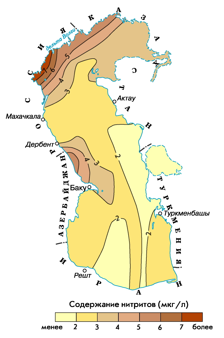
- increased concentrations of biogenic substances characterize the areas of pre-estuary seashores of rivers that feed the sea and shallow areas of the sea subject to active anthropogenic influence (Baku Bay, Turkmenbashi Bay, water areas adjacent to Makhachkala, Fort Shevchenko, etc.);
- The Northern Caspian, which is a vast mixing zone of river and sea waters, is characterized by significant spatial gradients in the distribution of nutrients;
- in the Middle Caspian, the cyclonic nature of the circulation contributes to the upwelling of deep waters with a high content of nutrients into the overlying layers of the sea;
- in the deep water areas of the Middle and South Caspian, the vertical distribution of nutrients depends on the intensity of the convective mixing process, and their content increases with depth.
The dynamics of nutrient concentrations during the year in the Caspian Sea is influenced by such factors as seasonal fluctuations in the biogenic runoff into the sea, the seasonal ratio of production-destruction processes, the intensity of exchange between soil and water mass, ice conditions in winter time in the Northern Caspian, the processes of winter vertical circulation in the deep sea areas.
In winter, a significant area of the Northern Caspian is covered with ice, but biochemical processes are actively developing in the under-ice water and ice. The ice of the Northern Caspian, being a kind of accumulator of biogenic substances, transforms these substances entering the sea from and from the atmosphere.
As a result of the winter vertical circulation of waters in the deep-sea regions of the Middle and Southern Caspian in the cold season, the active layer of the sea is enriched with nutrients due to their supply from the underlying layers.
Spring for the waters of the North Caspian is characterized by a minimum content of phosphates, nitrites and silicon, which is explained by the spring outbreak of phytoplankton development (silicon is actively consumed by diatoms). High concentrations of ammonium and nitrate nitrogen, characteristic of the waters of a large area of the Northern Caspian during floods, are due to intensive flushing by river waters.
In the spring season, in the area of water exchange between the Northern and Middle Caspian in the subsurface layer, with the maximum oxygen content, the content of phosphates is minimal, which, in turn, indicates the activation of the photosynthesis process in this layer.
In the South Caspian, the distribution of nutrients in spring is basically similar to their distribution in the Middle Caspian.
IN summer time in the waters of the Northern Caspian, a redistribution of various forms of biogenic compounds is found. Here, the content of ammonium nitrogen and nitrates significantly decreases, while at the same time there is a slight increase in the concentrations of phosphates and nitrites and a rather significant increase in the concentration of silicon. In the Middle and South Caspian, the concentration of phosphates has decreased due to their consumption in the process of photosynthesis and the difficulty of water exchange with the deep water accumulation zone.
In autumn, in the Caspian Sea, due to the cessation of the activity of some types of phytoplankton, the content of phosphates and nitrates increases, and the concentration of silicon decreases, as an autumn outbreak of diatoms occurs.
Oil has been produced on the shelf of the Caspian Sea for more than 150 years.
Currently, large reserves of hydrocarbons are being developed on the Russian shelf, the resources of which on the Dagestan shelf are estimated at 425 million tons of oil equivalent (of which 132 million tons of oil and 78 billion m3 of gas), on the shelf of the Northern Caspian - 1 billion tons of oil .
In total, about 2 billion tons of oil have already been produced in the Caspian.
Losses of oil and products of its processing during extraction, transportation and use reach 2% of the total volume.
The main sources of pollutants, including oil products, entering the Caspian Sea are carry-over with river runoff, discharge of untreated industrial and agricultural effluents, domestic wastewater from cities and towns located on the coast, shipping, exploration and exploitation of oil and gas fields located at the bottom of the sea, transportation of oil by sea. 90% of pollutants with river runoff are concentrated in the Northern Caspian, industrial effluents are confined mainly to the area of the Apsheron Peninsula, and increased oil pollution of the Southern Caspian is associated with oil production and oil exploration drilling, as well as active volcanic activity (mud) in zone of oil and gas bearing structures.
From the territory of Russia, about 55 thousand tons of oil products enter the Northern Caspian every year, including 35 thousand tons (65%) from the Volga River and 130 tons (2.5%) from the Terek and Sulak rivers.
The thickening of the film on the water surface up to 0.01 mm disrupts the processes of gas exchange and threatens the death of hydrobiota. Toxic for fish is the concentration of oil products 0.01 mg/l, for phytoplankton - 0.1 mg/l.

The development of oil and gas resources of the bottom of the Caspian Sea, the estimated reserves of which are estimated at 12–15 billion tons of standard fuel, will become the main factor in the anthropogenic load on the ecosystem of the sea in the coming decades.
Caspian autochthonous fauna. Total number autochthons - 513 species or 43.8% of the entire fauna, which include herring, gobies, mollusks, etc.
arctic views. The total number of the Arctic group is 14 species and subspecies, or only 1.2% of the entire fauna of the Caspian (mysids, sea cockroach, white salmon, Caspian salmon, Caspian seal, etc.). The basis of the Arctic fauna is crustaceans (71.4%), which easily tolerate desalination and live on great depths The Middle and Southern Caspian (from 200 to 700 m), since the lowest water temperatures (4.9–5.9 ° C) are kept here throughout the year.
mediterranean views. These are 2 types of mollusks, needle-fish, etc. At the beginning of the 20s of our century, the mollusk mitilyastra penetrated here, later 2 types of shrimp (with mullets, during their acclimatization), 2 types of mullet and flounder. Some Mediterranean species entered the Caspian after the opening of the Volga-Don Canal. Mediterranean species play a significant role in the fish food base of the Caspian Sea.

Freshwater fauna (228 species). This group includes anadromous and semi-anadromous fish (sturgeon, salmon, pike, catfish, cyprinids, as well as rotifers).
sea views. These are ciliates (386 forms), 2 species of foraminifera. There are especially many endemics among higher crustaceans (31 species), gastropod molluscs (74 species and subspecies), bivalve mollusks (28 species and subspecies) and fish (63 species and subspecies). The abundance of endemics in the Caspian Sea makes it one of the most unique brackish water bodies on the planet.
The Caspian Sea provides more than 80% of the world's sturgeon catch, most of which falls on the North Caspian.
To increase the catches of sturgeon, which dropped sharply during the years of sea level drop, a set of measures is being implemented. Among them - a complete ban on sturgeon fishing in the sea and its regulation in rivers, an increase in the scale of factory breeding of sturgeons.
I would be grateful if you share this article on social networks:
It is known that the sea is part of the oceans. From this geographically correct point of view, the Caspian cannot be considered a sea, because it is separated from the ocean by huge land masses. The shortest distance from the Caspian to the Black Sea, the closest of the seas included in the system of the World Ocean, is 500 kilometers. Therefore, it would be more correct to speak of the Caspian as a lake. This is the world's largest lake, often referred to simply as the Caspian or lake-sea.
The Caspian Sea has a number of features of the sea: its water is salty (however, there are other salt lakes), the area is not much inferior to the area of such seas as the Black, Baltic, Red, Northern, and even exceeds the area of Azov and some others (however, Canadian Lake Superior also huge area, like the three Seas of Azov). In the Caspian, fierce storm winds and huge waves are frequent (and this is not uncommon in Baikal).
So, after all, the Caspian Sea is a lake? That's Wikipedia says it Yes, and the Great Soviet Encyclopedia answers that no one has yet been able to give an exact definition of this issue - "A generally accepted classification does not exist."
Do you know why this is very important and fundamental? And here's why...
The lake belongs to internal waters - the sovereign territories of coastal states, to which the international regime does not apply (the principle of non-intervention of the UN in the internal affairs of states). But the water area of the sea is divided differently, and the rights of coastal states are completely different here.
In terms of its geographical position, the Caspian itself, in contrast to the land territories surrounding it, has not been the object of any targeted attention from the coastal states for many centuries. Only at the beginning of the XIX century. between Russia and Persia, the first treaties were concluded: Gulistan (1813) 4 and Turkmanchaisky (1828), summing up the results of the Russian-Persian war, as a result of which Russia annexed a number of Transcaucasian territories and received the exclusive right to maintain a navy in the Caspian Sea. Russian and Persian merchants were allowed to freely trade on the territory of both states and use the Caspian Sea to transport goods. The Turkmanchay Treaty confirmed all these provisions and became the basis for maintaining international relations between the parties until 1917.
After the October Revolution of 1917, in a note dated January 14, 1918, by the new Russian government that came to power, it renounced its exclusive military presence in the Caspian Sea. The agreement between the RSFSR and Persia of February 26, 1921 declared invalid all agreements concluded before it by the tsarist government. The Caspian Sea became a body of water for common use by the parties: both states were granted equal rights of free navigation, except in cases where the crews of Iranian ships could include citizens of third countries using the service for unfriendly purposes (Article 7). The 1921 agreement did not provide for a maritime border between the parties.
In August 1935, the following treaty was signed, the parties to which were new subjects of international law - the Soviet Union and Iran, which acted under the new name. The parties reaffirmed the provisions of the 1921 agreement, but introduced into the agreement a new concept for the Caspian - a 10-mile fishing zone, which limited the spatial limits of this fishery for its participants. This was done in order to control and conserve the living resources of the reservoir.
In the context of the outbreak of World War II, unleashed by Germany, an urgent need arose to conclude a new treaty between the USSR and Iran on trade and navigation in the Caspian. The reason for this was anxiety Soviet side, caused by Germany's interest in intensifying its trade relations with Iran and the danger of using the Caspian Sea as one of the stages of the transit route. The treaty signed between the USSR and Iran in 1940 10 protected the Caspian Sea from such a prospect: it repeated the main provisions of the previous agreements, which provided for the stay in its waters of the ships of only these two Caspian states. It also included a provision for its indefinite validity.
collapse Soviet Union radically changed the regional situation in the former Soviet space, in particular in the Caspian region. Among the large number of new problems, the problem of the Caspian also arose. Instead of two states - the USSR and Iran, which previously bilaterally resolved all emerging issues of maritime navigation, fishing and the use of its other living and non-living resources, now there are five of them. Of the former, only Iran remained, Russia took the place of the USSR on the rights of succession, the remaining three are new states: Azerbaijan, Kazakhstan, Turkmenistan. They used to have access to the Caspian, but only as republics of the USSR, and not as independent states. Now, having become independent and sovereign, they have the opportunity to participate on an equal footing with Russia and Iran in the discussion and decision-making in the consideration of all the above issues. This was also reflected in the attitude of these states to the Caspian, since all five states that had access to it showed equal interest in the use of its living and non-living resources. And this is logical, and most importantly, justified: the Caspian Sea is rich in natural resources, both fish stocks and black gold - oil and blue fuel - gas. Exploration and production of the last two resources have long been the subject of the most heated and protracted negotiations. But not only them.
In addition to the presence of rich mineral resources, about 120 species and subspecies of fish live in the waters of the Caspian Sea, here is the world gene pool of sturgeons, the extraction of which, until recently, accounted for 90% of their total world catch.
Due to its location, the Caspian Sea has traditionally and long been widely used for navigation, acting as a kind of transport artery between the peoples of the coastal states. Along its banks are such large seaports, as the Russian Astrakhan, the capital of Azerbaijan Baku, the Turkmen Turkmenbashi, the Iranian Anzeli and the Kazakh Aktau, between which trade, cargo and passenger sea transport routes have long been laid.
And yet, the main object of attention of the Caspian states is its mineral resources - oil and natural gas, to which each of them can claim within the limits that should be determined by them collectively on the basis of international law. And for this, they will have to divide between themselves both the Caspian Sea and its bottom, in the bowels of which its oil and gas are hidden, and develop rules for their extraction with minimal damage to a very fragile environment, primarily the marine environment and its living inhabitants.
The main obstacle in resolving the issue of the beginning of a wide extraction of the mineral resources of the Caspian Sea for the Caspian states continues to be its international legal status: should it be considered a sea or a lake? The complexity of the issue lies in the fact that these states themselves must solve it, and so far no agreement has been observed in their ranks. But at the same time, each of them seeks to start extracting Caspian oil and natural gas as soon as possible and make their sale abroad a permanent source of funds to form their budget.
Therefore, the oil companies of Azerbaijan, Kazakhstan and Turkmenistan, without waiting for the end of the settlement of existing disagreements on the territorial division of the Caspian, have already begun active production of its oil, in the hope of ceasing to be dependent on Russia, turning their countries into oil-producing countries and already in this capacity begin build their own long-term trade relations with neighbors.
However, the issue of the status of the Caspian Sea remains unresolved. Regardless of whether the Caspian states agree to consider it a “sea” or a “lake”, they will have to apply the principles corresponding to the choice made or develop their own for this case to the territorial division of its water area and bottom.
Kazakhstan was in favor of recognizing the Caspian as a sea. Such recognition will make it possible to apply to the division of the Caspian the provisions of the 1982 UN Convention on the Law of the Sea on Internal Waters, the Territorial Sea, the Exclusive Economic Zone, and the Continental Shelf. This would allow the coastal states to gain sovereignty over the subsoil of the territorial sea (Article 2) and exclusive rights to explore and develop the resources of the continental shelf (Article 77). But the Caspian cannot be called a sea from the standpoint of the UN Convention on the Law of the Sea of 1982, since this body of water is closed and has no natural connection with the oceans.
In this case, the option of joint use of its water area and bottom resources is also excluded.
In the treaties between the USSR and Iran, the Caspian Sea was considered as a border lake. With the legal status of a "lake" given to the Caspian Sea, it is supposed to be divided into sectors, as is done with respect to border lakes. But there is no norm in international law obliging states to do just that: division into sectors is an established practice.
The Russian Foreign Ministry has repeatedly made statements that the Caspian is a lake, and its waters and subsoil are the common property of the coastal states. Iran also considers the Caspian Sea as a lake from the position fixed in the treaties with the USSR. The country's government believes that this status implies the creation of a consortium for the unified management of the extraction and use of its resources by the Caspian states. Some authors also express this opinion, for example, R. Mammadov believes that with such a status, the extraction of hydrocarbon resources in the Caspian Sea by these states should be carried out jointly.
In the literature, there has been a proposal to give the Caspian Sea the status of a “sui generis” lake, and in this case we are talking about a special international legal status such a lake and its special regime. Under the regime, it is assumed that the states jointly develop their own rules for the use of its resources.
Thus, the recognition of the Caspian as a lake does not require its mandatory division into sectors - each coastal state has its own part. In addition, there are no norms in international law on the division of lakes between states: this is their good will, behind which certain internal interests may be hidden.
At present, all the Caspian states recognize that the modern legal regime was established by the established practice of its use, but now the Caspian is in actual common use not by two, but by five states. Even at the meeting of foreign ministers held in Ashgabat on November 12, 1996, the Caspian states confirmed that the status of the Caspian Sea could be changed only with the consent of all five coastal states. Later, this was also confirmed by Russia and Azerbaijan in a joint statement dated January 9, 2001 on the principles of cooperation, as well as in the Declaration on cooperation in the Caspian Sea signed between Kazakhstan and Russia dated October 9, 2000.
But in the course of numerous Caspian negotiations, conferences and four summits of the Caspian states (Ash-Khabad summit on April 23-24, 2002, Tehran summit on October 16, 2007, Baku summit on November 18, 2010 and Astrakhan summit on September 29, 2014 d.) the Caspian countries failed to reach agreement.
More productive so far is cooperation at the bilateral and trilateral levels. Back in May 2003, Russia, Azerbaijan and Kazakhstan signed an agreement on the junction of the lines of delimitation of adjacent sections of the bottom of the Caspian Sea, which was based on previous bilateral agreements. In the current situation, Russia, by its participation in these agreements, seemed to confirm that the agreements between the USSR and Iran are outdated and do not correspond to the existing realities.
In the Agreement of July 6, 1998 between the Russian Federation and the Republic of Kazakhstan on the delimitation of the bottom of the northern part of the Caspian Sea in order to exercise sovereign rights to subsoil use, the delimitation of the seabed between adjacent and opposite sides along a modified median line based on the principle of fairness was announced. - Livosti and agreements of the parties. At the bottom of the section, the states have sovereign rights, but their common use of the water surface is preserved.
Iran perceived this agreement as separate and violating the previous Treaties with the USSR of 1921 and 1940. However, it should be noted that in the preamble of the 1998 agreement, to which Russia and Kazakhstan were parties, the agreement was considered as a temporary measure pending the signing of the convention by all the Caspian states.
Later, on July 19 of the same year, Iran and Russia made a joint statement in which they proposed three possible scenarios for the delimitation of the Caspian Sea. First: the sea should be shared on the basis of the condominium principle. The second scenario boils down to dividing the water area, waters, bottom and subsoil into national sectors. The third scenario, which is a compromise between the first and second options, suggests dividing only the bottom between the coastal states, and considers the water surface to be common and open to all coastal countries.
The existing options for the delimitation of the Caspian Sea, including those mentioned above, are possible only if there is good political will on the part of the parties. Azerbaijan and Kazakhstan have clearly expressed their position from the very beginning of the process of multilateral consultations. Azerbaijan considers the Caspian Sea to be a lake and, therefore, it should be divided. Kazakhstan proposes to consider the Caspian as a closed sea, referring to the 1982 UN Convention (Articles 122, 123), and, accordingly, advocates its division in the spirit of the Convention. Turkmenistan has long supported the idea of joint management and use of the Caspian, but foreign companies already developing resources off the coast of Turkmenistan influenced the policy of its president, who began to object to the establishment of a condominium regime, supporting the position of dividing the sea.
Azerbaijan was the first of the Caspian states to start using the hydrocarbon resources of the Caspian under the new conditions. After the signing of the "Deal of the Century" in September 1994, Baku expressed a desire to declare the sector adjacent to it an integral part of its territory. This provision was also enshrined in the Constitution of Azerbaijan, adopted in order to exercise sovereign rights to subsoil use, Moscow, July 6, 1998 at a referendum on November 12, 1995 (Article 11). But such a radical position from the very beginning did not correspond to the interests of all other coastal states, especially Russia, which expresses fears that this will open access to the Caspian Sea to countries in other regions. Azerbaijan agreed to a compromise. In the Agreement between the Russian Federation and Azerbaijan on the delimitation of adjacent sections of the Caspian Sea in 2002, a provision was fixed in which the division of the bottom was carried out using the median line, and the water area of the reservoir remained in joint use.
Unlike Azerbaijan, which expressed a desire to completely divide the Caspian, Iran proposes to leave its bowels and water for joint use, but does not object to the option of dividing the Caspian into 5 equal parts. Accordingly, each member of the Caspian five would be allocated 20 percent of the total territory of the reservoir.
Russia's point of view was changing. For a long time Moscow insisted on the establishment of a condominium, but wishing to build a long-term policy with its neighbors, which did not benefit from considering the Caspian as the property of five coastal states, it changed its position. This then prompted the states to start a new stage of negotiations, after which, in 1998, the above Agreement was signed, where Russia declared that it was “ripe” for the division of the Caspian Sea. Its main principle was the position "the water is common - we divide the bottom."
Taking into account the fact that agreements have been reached between some of the Caspian states, namely Azerbaijan, Kazakhstan and Russia, on the conditional delimitation of spaces in the Caspian, we can conclude that they are actually satisfied with the already established regime with the division of its bottom along a modified median line and sharing the surface of the reservoir for navigation and fishing.
However, the lack of complete clarity and unity in the position of all countries of the coast prevents the Caspian states themselves from developing oil production. And oil is of key importance to them. There are no unequivocal data regarding their reserves in the Caspian Sea. According to the US Energy Information Agency in 2003, the Caspian was ranked second in oil reserves and third in gas reserves. The data of the Russian side is different: they speak of an artificial overestimation by Western experts of the energy resources of the Caspian Sea. Differences in assessments are due to the political and economic interests of regional and external players. The data distortion factor was the geopolitical significance of the region, with which the foreign policy plans of the US and the EU are connected. Zbigniew Brzezinski back in 1997 expressed the opinion that this region is the "Eurasian Balkans".
The Caspian Sea is located at the junction of two parts of the Eurasian continent - Europe and Asia. The Caspian Sea is similar in shape to the Latin letter S, the length of the Caspian Sea from north to south is approximately 1200 kilometers (36°34" - 47°13" N), from west to east - from 195 to 435 kilometers, on average 310-320 kilometers (46° - 56° E).
The Caspian Sea is conditionally divided according to physical and geographical conditions into 3 parts - the Northern Caspian, the Middle Caspian and the Southern Caspian. The conditional border between the North and the Middle Caspian we pass along the Chechen line (island)- Tyub-Karagansky Cape, between the Middle and South Caspian - along the line of the Residential (island)- Gan Gulu (cape). The area of the Northern, Middle and Southern Caspian is 25, 36, 39 percent respectively.
According to one of the hypotheses, the Caspian Sea got its name in honor of the ancient tribes of horse breeders - the Caspians, who lived BC on southwest coast Caspian Sea. Throughout the history of its existence, the Caspian Sea had about 70 names for different tribes and peoples: the Hyrcanian Sea; The Khvalyn Sea or the Khvalis Sea is an ancient Russian name, derived from the name of the inhabitants of Khorezm, who traded in the Caspian Sea - Khvalis; Khazar Sea - name in Arabic (Bahr-al-Khazar), Persian (Daria-e Khazar), Turkish and Azerbaijani (Khazar Denizi) languages; Abeskun Sea; Saray Sea; Derbent Sea; Sihai and other names. In Iran, the Caspian Sea is still called the Khazar or Mazenderan (by the name of the people inhabiting the coastal province of Iran of the same name).
The coastline of the Caspian Sea is estimated at about 6500 - 6700 kilometers, with islands - up to 7000 kilometers. The shores of the Caspian Sea in most of its territory are low-lying and smooth. In the northern part, the coastline is indented by water streams and islands of the Volga and Ural deltas, the shores are low and swampy, and the water surface is covered with thickets in many places. On east coast limestone coasts adjoining semi-deserts and deserts predominate. The most winding coasts are on the west coast in the area of the Apsheron Peninsula and on the east coast in the area of the Kazakh Gulf and Kara-Bogaz-Gol.
Large peninsulas of the Caspian Sea: Agrakhan Peninsula, Absheron Peninsula, Buzachi, Mangyshlak, Miankale, Tub-Karagan.
There are about 50 large and medium-sized islands in the Caspian Sea with a total area of approximately 350 square kilometers. Most major islands: Ashur-Ada, Garasu, Gum, Dash, Zira (island), Zyanbil, Kyur Dashy, Khara-Zira, Sengi-Mugan, Chechnya (island), Chygyl.
Large bays of the Caspian Sea: Agrakhansky Bay, Komsomolets (bay) (former Dead Kultuk, former Tsesarevich Bay), Kaydak, Mangyshlak, Kazakh (bay), Turkmenbashi (bay) (former Krasnovodsk), Turkmen (bay), Gyzylagach, Astrakhan (bay), Gyzlar, Girkan (former Astarabad) and Anzeli (former Pahlavi).
Off the eastern coast is the salt lake Kara Bogaz Gol, which until 1980 was a bay-lagoon of the Caspian Sea, connected to it by a narrow strait. In 1980, a dam was built separating Kara-Bogaz-Gol from the Caspian Sea, in 1984 a culvert was built, after which the level of Kara-Bogaz-Gol dropped by several meters. In 1992, the strait was restored, through which water leaves the Caspian Sea to Kara-Bogaz-Gol and evaporates there. Every year, 8-10 cubic kilometers of water enters Kara-Bogaz-Gol from the Caspian Sea (according to other sources - 25 thousand kilometers) and about 150 thousand tons of salt.
130 rivers flow into the Caspian Sea, of which 9 rivers have a mouth in the form of a delta. Large rivers flowing into the Caspian Sea - Volga, Terek (Russia), Ural, Emba (Kazakhstan), Kura (Azerbaijan), Samur (border of Russia with Azerbaijan), Atrek (Turkmenistan) and others. The largest river flowing into the Caspian Sea is the Volga, its average annual runoff is 215-224 cubic kilometers. The Volga, Ural, Terek and Emba provide up to 88 - 90% of the annual drainage of the Caspian Sea.
The area of the Caspian Sea basin is approximately 3.1 - 3.5 million square kilometers, which is approximately 10 percent of the world's closed water basins. The length of the Caspian Sea basin from north to south is about 2,500 kilometers, from west to east - about 1,000 kilometers. The Caspian Sea basin covers 9 states - Azerbaijan, Armenia, Georgia, Iran, Kazakhstan, Russia, Uzbekistan, Turkey and Turkmenistan.
The Caspian Sea washes the shores of five coastal states:
- Russia (Dagestan, Kalmykia and Astrakhan region) - in the west and northwest, the length of the coastline is 695 kilometers
- Kazakhstan - in the north, northeast and east, the length of the coastline is 2320 kilometers
- Turkmenistan - in the southeast, the length of the coastline is 1200 kilometers
- Iran - in the south, the length of the coastline - 724 kilometers
- Azerbaijan - in the southwest, the length of the coastline is 955 kilometers
The largest city - a port on the Caspian Sea - Baku, the capital of Azerbaijan, which is located in the southern part of the Absheron Peninsula and has 2,070 thousand people (2003) . Other large Azerbaijani Caspian cities are Sumgayit, which is located in the northern part of the Absheron Peninsula, and Lankaran, which is located near the southern border of Azerbaijan. To the South-East of the Absheron Peninsula, there is a settlement of oil workers Neftyanye Kamni, whose facilities are located on artificial islands, overpasses and technological sites.
Large Russian cities - the capital of Dagestan Makhachkala and the most Southern City Russia's Derbent - located on the western coast of the Caspian Sea. port city Astrakhan is also considered to be part of the Caspian Sea, which, however, is not located on the shores of the Caspian Sea, but in the Volga delta, 60 kilometers from the northern coast of the Caspian Sea.
On the eastern shore of the Caspian Sea is the Kazakh city - the port of Aktau, in the north in the Ural delta, 20 km from the sea, the city of Atyrau is located, south of Kara-Bogaz-Gol on the northern shore of the Krasnovodsk Bay - the Turkmen city of Turkmenbashi, formerly Krasnovodsk. Several Caspian cities are located in the southern (Iranian) coast, the largest of them - Anzeli.
The area and volume of water in the Caspian Sea varies significantly depending on fluctuations in water levels. At a water level of -26.75 m, the area was approximately 392,600 square kilometers, the volume of water was 78,648 cubic kilometers, which is approximately 44 percent of the world's lake water reserves. The maximum depth of the Caspian Sea is in the South Caspian depression, 1025 meters from its surface level. In terms of maximum depth, the Caspian Sea is second only to Baikal (1620 m.) and Tanganyika (1435 m.). The average depth of the Caspian Sea, calculated from the bathygraphic curve, is 208 meters. At the same time, the northern part of the Caspian Sea is shallow, its maximum depth does not exceed 25 meters, and average depth- 4 meters.
The water level in the Caspian Sea is subject to significant fluctuations. According to modern science, over the past 3 thousand years, the amplitude of changes in the water level of the Caspian Sea was 15 meters. Instrumental measurement of the level of the Caspian Sea and systematic observations of its fluctuations have been carried out since 1837, during this time the highest water level was recorded in 1882 (-25.2 m.), the lowest - in 1977 (-29.0 m.), since 1978 the water level has risen and in 1995 reached -26.7 m, since 1996 there has been a downward trend again. Scientists associate the causes of changes in the water level of the Caspian Sea with climatic, geological and anthropogenic factors.
The water temperature is subject to significant latitudinal changes, most pronounced in winter, when the temperature varies from 0 - 0.5 °C at the ice edge in the north of the sea to 10 - 11 °C in the south, i.e. the water temperature difference is about 10 °C. For shallow water areas with depths less than 25 m, the annual amplitude can reach 25 - 26 °C. On average, the water temperature near the western coast is 1 - 2 °C higher than that of the eastern coast, and in the open sea the water temperature is 2 - 4 °C higher than near the coasts. According to the nature of the horizontal structure of the temperature field in the annual cycle of variability, three time intervals can be distinguished in the upper 2-m layer. From October to March, the water temperature increases in the south and east, which is especially evident in the Middle Caspian. Two stable quasi-latitudinal zones can be distinguished, where the temperature gradients are increased. This is, firstly, the border between the North and Middle Caspian, and, secondly, between the Middle and South. At the ice edge, in the northern frontal zone, the temperature in February-March increases from 0 to 5 °C, in the southern frontal zone, in the area of the Apsheron threshold, from 7 to 10 °C. During this period, the least chilled waters are in the center of the South Caspian, which form a quasi-stationary core. In April-May, the area of minimum temperatures moves to the Middle Caspian, which is associated with faster warming of waters in the shallow northern part of the sea. True, at the beginning of the season in the northern part of the sea, a large amount of heat is spent on melting ice, but already in May the temperature rises here to 16 - 17 °C. In the middle part, the temperature at this time is 13 - 15 °C, and in the south it rises to 17 - 18 °C. The spring warming of the water evens out horizontal gradients, and the temperature difference between coastal areas and open sea does not exceed 0.5 °C. The heating of the surface layer, which begins in March, breaks the uniformity in the temperature distribution with depth. In June-September, there is a horizontal uniformity in the temperature distribution in the surface layer. In August, which is the month of the greatest warming, the water temperature throughout the sea is 24 - 26 °C, and in the southern regions it rises to 28 °C. In August, the water temperature in shallow bays, for example, in Krasnovodsk, can reach 32 °C. The main feature of the water temperature field at this time is upwelling. It is observed annually along the entire eastern coast of the Middle Caspian and partially penetrates even into the South Caspian. The rise of cold deep waters occurs with varying intensity as a result of the influence of northwestern winds prevailing in the summer season. Wind this direction causes the outflow of warm surface waters from the coast and the rise of colder waters from the intermediate layers. Upwelling starts in June, but it reaches its highest intensity in July-August. As a result, there is a decrease in temperature on the surface of the water. (7 - 15°C). Horizontal temperature gradients reach 2.3 °C at the surface and 4.2 °C at a depth of 20 m. in June to 43 - 45 ° N in September. Summer upwelling has great importance for the Caspian Sea, radically changing the dynamic processes in the deep water area. In the open areas of the sea in late May - early June, the formation of a temperature jump layer begins, which is most clearly expressed in August. Most often, it is located between the horizons of 20 and 30 m in the middle part of the sea and 30 and 40 m in the southern part. Vertical temperature gradients in the shock layer are very significant and can reach several degrees per meter. In the middle part of the sea, due to the surge near the eastern coast, the shock layer rises close to the surface. Since there is no stable baroclinic layer in the Caspian Sea with a large potential energy reserve similar to the main thermocline of the World Ocean, with the cessation of the effect of the prevailing winds that cause upwelling, and with the onset of autumn-winter convection in October-November, the temperature fields are rapidly reorganized to the winter regime. In the open sea, the water temperature in the surface layer drops in the middle part to 12 - 13 °C, in the southern part to 16 - 17 °C. In the vertical structure, the shock layer is washed out due to convective mixing and disappears by the end of November.
The salt composition of the waters of the closed Caspian Sea differs from that of the ocean. There are significant differences in the ratios of the concentrations of salt-forming ions, especially for the waters of areas under the direct influence of continental runoff. The process of metamorphization of sea waters under the influence of continental runoff leads to a decrease in the relative content of chlorides in the total amount of salts in sea waters, an increase in the relative amount of carbonates, sulfates, and calcium, which are the main components in the chemical composition of river waters. The most conservative ions are potassium, sodium, chloride and magnesium. The least conservative are calcium and bicarbonate ion. In the Caspian Sea, the content of calcium and magnesium cations is almost two times higher than in the Sea of Azov, and sulfate anion is three times higher. The salinity of water changes especially sharply in the northern part of the sea: from 0.1 units. psu in the mouth areas of the Volga and the Urals up to 10 - 11 units. psu on the border with the Middle Caspian. Mineralization in shallow saline bays-kultuks can reach 60 - 100 g/kg. In the Northern Caspian, during the entire ice-free period from April to November, a quasi-latitudinal salinity front is observed. The greatest desalination associated with the spread of river runoff over the sea area is observed in June. The formation of the salinity field in the Northern Caspian is greatly influenced by the wind field. In the middle and southern parts of the sea, salinity fluctuations are small. Basically, it is 11.2 - 12.8 units. psu, increasing in the south and east directions. Salinity increases slightly with depth. (at 0.1 - 0.2 psu). In the deep-water part of the Caspian Sea, in the vertical salinity profile, characteristic troughs of isohalines and local extrema are observed in the area of the eastern continental slope, which indicate the processes of near-bottom creep of waters becoming saline in the eastern shallow waters of the South Caspian. Salinity is also highly dependent on sea level and (which is related) from the amount of continental runoff.
The relief of the northern part of the Caspian is a shallow wavy plain with banks and accumulative islands, the average depth of the Northern Caspian is about 4 - 8 meters, the maximum does not exceed 25 meters. The Mangyshlak threshold separates the Northern Caspian from the Middle. The Middle Caspian is quite deep, the depth of water in the Derbent depression reaches 788 meters. The Apsheron threshold separates the Middle and South Caspian. The South Caspian is considered deep water, the depth of water in the South Caspian depression reaches 1025 meters from the surface of the Caspian Sea. Shell sands are widespread on the Caspian shelf, deep-water areas are covered with silty sediments, and in some areas there is an outcrop of bedrock.
The climate of the Caspian Sea is continental in the northern part, temperate in the middle part and subtropical in the southern part. In winter, the average monthly temperature of the Caspian varies from -8 -10 in the northern part to +8 - +10 in the southern part, in summer - from +24 - +25 in the northern part to +26 - +27 in the southern part. Maximum temperature fixed on the east coast - 44 degrees.
The average annual rainfall is 200 millimeters per year, ranging from 90-100 millimeters in the arid eastern part to 1,700 millimeters off the southwestern subtropical coast. Evaporation of water from the surface of the Caspian Sea is about 1000 millimeters per year, the most intense evaporation in the area of the Absheron Peninsula and in the eastern part of the South Caspian is up to 1400 millimeters per year.
Winds often blow on the territory of the Caspian Sea, their average annual speed is 3-7 meters per second, north winds prevail in the wind rose. In the autumn and winter months, the winds increase, the wind speed often reaches 35-40 meters per second. The most windy territories are the Apsheron Peninsula and the environs of Makhachkala-Derbent, the most high wave- 11 meters.
The circulation of water in the Caspian Sea is connected with the runoff and winds. Since most of the water flow falls on the Northern Caspian, northern currents predominate. An intense northern current carries water from the Northern Caspian along the western coast to the Absheron Peninsula, where the current is divided into two branches, one of which moves further along the western coast, the other goes to the Eastern Caspian.
The fauna of the Caspian Sea is represented by 1810 species, of which 415 are vertebrates. 101 species of fish are registered in the Caspian world, and most of the world's stocks of sturgeon are concentrated in it, as well as such freshwater fish as vobla, carp, pike perch. The Caspian Sea is the habitat of such fish as carp, mullet, sprat, kutum, bream, salmon, perch, pike. Also found in the Caspian Sea marine mammal- Caspian seal. Since March 31, 2008, 363 dead seals have been found on the coast of the Caspian Sea in Kazakhstan.
The flora of the Caspian Sea and its coast is represented by 728 species. Of the plants in the Caspian Sea, algae predominate - blue-green, diatoms, red, brown, char and others, of flowering - zoster and ruppia. By origin, the flora belongs mainly to the Neogene age, however, some plants were brought into the Caspian Sea by man either consciously or on the bottoms of ships.
, Kazakhstan, Turkmenistan, Iran , Azerbaijan
Geographical position

Caspian Sea - view from space.
The Caspian Sea is located at the junction of two parts of the Eurasian continent - Europe and Asia. The length of the Caspian Sea from north to south is approximately 1200 kilometers (36°34 "-47°13" N), from west to east - from 195 to 435 kilometers, on average 310-320 kilometers (46°-56° v. d.).
The Caspian Sea is conditionally divided according to physical and geographical conditions into 3 parts - the North Caspian, the Middle Caspian and the South Caspian. The conditional border between the North and Middle Caspian runs along the line of about. Chechnya - Cape Tyub-Karagansky, between the Middle and South Caspian - along the line of about. Residential - Cape Gan-Gulu. The area of the Northern, Middle and Southern Caspian is 25, 36, 39 percent respectively.
Coast of the Caspian Sea

Coast of the Caspian Sea in Turkmenistan
The territory adjacent to the Caspian Sea is called the Caspian Sea.
Peninsulas of the Caspian Sea
- Ashur-Ada
- Garasu
- Zyanbil
- Hara Zira
- Sengi-Mugan
- Chygyl
Bays of the Caspian Sea
- Russia (Dagestan, Kalmykia and Astrakhan region) - in the west and north-west, the length of the coastline is about 1930 kilometers
- Kazakhstan - in the north, northeast and east, the length of the coastline is about 2320 kilometers
- Turkmenistan - in the southeast, the length of the coastline is about 650 kilometers
- Iran - in the south, the length of the coastline is about 1000 kilometers
- Azerbaijan - in the southwest, the length of the coastline is about 800 kilometers
Cities on the coast of the Caspian Sea
On the Russian coast there are cities - Lagan, Makhachkala, Kaspiysk, Izberbash and the southernmost city of Russia Derbent. Astrakhan is also considered a port city of the Caspian Sea, which, however, is not located on the shores of the Caspian Sea, but in the Volga Delta, 60 kilometers from the northern coast of the Caspian Sea.
Physiography
Area, depth, volume of water
The area and volume of water in the Caspian Sea varies significantly depending on fluctuations in water levels. At a water level of -26.75 m, the area is approximately 371,000 square kilometers, the volume of water is 78,648 cubic kilometers, which is approximately 44% of the world's lake water reserves. The maximum depth of the Caspian Sea is in the South Caspian depression, 1025 meters from its surface level. In terms of maximum depth, the Caspian Sea is second only to Baikal (1620 m) and Tanganyika (1435 m). The average depth of the Caspian Sea, calculated from the bathygraphic curve, is 208 meters. At the same time, the northern part of the Caspian Sea is shallow, its maximum depth does not exceed 25 meters, and the average depth is 4 meters.
Water level fluctuations
Vegetable world
The flora of the Caspian Sea and its coast is represented by 728 species. Of the plants in the Caspian Sea, algae predominate - blue-green, diatoms, red, brown, char and others, of flowering - zoster and ruppia. By origin, the flora belongs mainly to the Neogene age, however, some plants were brought into the Caspian Sea by man either consciously or on the bottoms of ships.
History of the Caspian Sea
Origin of the Caspian Sea
Anthropological and cultural history of the Caspian Sea
Finds in the Khuto cave near the southern coast of the Caspian Sea indicate that a person lived in these parts about 75 thousand years ago. The first mention of the Caspian Sea and the tribes living on its coast are found in Herodotus. Approximately in the V-II centuries. BC e. Saka tribes lived on the coast of the Caspian Sea. Later, during the period of the settlement of the Turks, in the period of the 4th-5th centuries. n. e. Talysh tribes (Talysh) lived here. According to ancient Armenian and Iranian manuscripts, the Russians sailed the Caspian Sea from the 9th-10th centuries.
Exploration of the Caspian Sea
The exploration of the Caspian Sea was started by Peter the Great, when, on his orders, an expedition was organized in 1714-1715 under the leadership of A. Bekovich-Cherkassky. In the 1720s, hydrographic studies were continued by the expedition of Karl von Werden and F.I. Soymonov, later by I.V. Tokmachev, M.I. Voinovich and other researchers. At the beginning of the 19th century, instrumental surveying of the banks was carried out by I.F. Kolodkin, in the middle of the 19th century. - instrumental geographic survey under the guidance of N. A. Ivashintsev. Since 1866, for more than 50 years, expeditionary research on the hydrology and hydrobiology of the Caspian Sea has been carried out under the leadership of N. M. Knipovich. In 1897, the Astrakhan Research Station was founded. In the first decades of Soviet power in the Caspian Sea, geological research by I. M. Gubkin and other Soviet geologists was actively carried out, mainly aimed at finding oil, as well as research on the study of the water balance and fluctuations in the level of the Caspian Sea.
Economy of the Caspian Sea
Mining of oil and gas
Many oil and gas fields are being developed in the Caspian Sea. The proven oil resources in the Caspian Sea are about 10 billion tons, the total resources of oil and gas condensate are estimated at 18-20 billion tons.
Oil production in the Caspian Sea began in 1820, when the first oil well was drilled on the Absheron shelf near Baku. In the second half of the 19th century, oil production began on an industrial scale on the Absheron Peninsula, and then on other territories.
Shipping
Shipping is developed in the Caspian Sea. On the Caspian Sea ferry crossings, in particular, Baku - Turkmenbashi, Baku - Aktau, Makhachkala - Aktau. The Caspian Sea has a navigable connection with the Sea of Azov through the Volga and Don rivers and the Volga-Don Canal.
Fishing and seafood
Fishing (sturgeon, bream, carp, pike perch, sprat), caviar, and seal fishing. More than 90 percent of the world's sturgeon catch is carried out in the Caspian Sea. In addition to industrial production, illegal production of sturgeon and their caviar flourishes in the Caspian Sea.
Recreational resources
The natural environment of the Caspian coast with sandy beaches, mineral waters and therapeutic mud in the coastal zone creates good conditions for relaxation and treatment. At the same time, in terms of the degree of development of resorts and the tourism industry, the Caspian coast noticeably loses to the Black Sea coast of the Caucasus. At the same time, in recent years, the tourism industry has been actively developing on the coast of Azerbaijan, Iran, Turkmenistan and Russian Dagestan. Azerbaijan is actively developing resort area in the Baku region. At the moment, a world-class resort has been created in Amburan, another modern tourist complex is being built near the village of Nardaran, recreation in the sanatoriums of the villages of Bilgah and Zagulba is very popular. A resort area is also being developed in Nabran, in the north of Azerbaijan. However high prices, in general, the low level of service and the lack of advertising lead to the fact that on Caspian resorts almost no foreign tourists. The development of the tourism industry in Turkmenistan is hampered by a long policy of isolation, in Iran - Sharia law, due to which mass recreation foreign tourists on the Caspian coast of Iran is impossible.
Ecological problems
The environmental problems of the Caspian Sea are associated with water pollution as a result of oil production and transportation on the continental shelf, the flow of pollutants from the Volga and other rivers flowing into the Caspian Sea, the vital activity of coastal cities, as well as the flooding of individual objects due to the rise in the level of the Caspian Sea. Predatory harvesting of sturgeons and their caviar, rampant poaching lead to a decrease in the number of sturgeons and forced restrictions on their production and export.
International status of the Caspian Sea
Legal status of the Caspian Sea
After the collapse of the USSR, the division of the Caspian Sea has long been and still remains the subject of unsettled disagreements related to the division of the resources of the Caspian shelf - oil and gas, as well as biological resources. For a long time there were negotiations between the Caspian states on the status of the Caspian Sea - Azerbaijan, Kazakhstan and Turkmenistan insisted on dividing the Caspian along the median line, Iran - on dividing the Caspian along one fifth between all the Caspian states.
With regard to the Caspian Sea, the key is the physical and geographical circumstance that it is a closed inland water body that does not have a natural connection with the World Ocean. Accordingly, the norms and concepts of international maritime law, in particular, the provisions of the UN Convention on the Law of the Sea of 1982, should not automatically apply to the Caspian Sea. Based on this, it would be unlawful to apply such concepts as “territorial sea”, “exclusive economic zone”, “continental shelf”, etc.
The current legal regime of the Caspian Sea was established by the Soviet-Iranian treaties of 1921 and 1940. These treaties provide for freedom of navigation throughout the sea, freedom of fishing, with the exception of ten-mile national fishing zones, and a ban on navigation in its waters of ships flying the flag of non-Caspian states.
Negotiations on the legal status of the Caspian are currently ongoing.
Delimitation of sections of the bottom of the Caspian Sea for the purpose of subsoil use
The Russian Federation concluded an agreement with Kazakhstan on the delimitation of the bottom of the northern part of the Caspian Sea in order to exercise sovereign rights to subsoil use (dated July 6, 1998 and the Protocol dated May 13, 2002), an agreement with Azerbaijan on the delimitation of adjacent sections of the bottom of the northern part of the Caspian Sea (dated September 23, 2002), as well as the trilateral Russian-Azerbaijani-Kazakhstan agreement on the junction point of the demarcation lines of adjacent sections of the bottom of the Caspian Sea (dated May 14, 2003), which established the geographical coordinates of the dividing lines limiting the sections of the bottom, within which the parties exercise their sovereign rights in the field of exploration and production of mineral resources.
The Caspian Sea is the largest enclosed body of water on the planet Earth, located on the continent of Eurasia - in border area states Russia, Kazakhstan, Turkmenistan, Iran and Azerbaijan. In fact, it is a giant lake left after the disappearance of the ancient Tethys ocean. Nevertheless, there is every reason to consider it as an independent sea (this is indicated by salinity, a large area and decent depth, the bottom of the oceanic crust and other signs). By maximum depth is the third among closed reservoirs - after lakes Baikal and Tanganyika. In the northern part of the Caspian Sea (a few kilometers from north coast- parallel to it) is the geographical border between Europe and Asia.
- Other names: throughout the history of mankind, different peoples of the Caspian Sea had about 70 different names. The most famous of them are: Khvalynskoe or Khvalisskoe (it took place during Ancient Rus', arose on behalf of the people praise who lived in the Northern Caspian and traded with the Russians), Girkan or Dzhurdzhan (descended from alternative titles the city of Gorgan, located in Iran), Khazar, Abeskun (after the name of the island and the city in the Kura delta - now flooded), Saray, Derbent, Sikhay.
- Origin of name: according to one of the hypotheses, the Caspian Sea received its modern and most ancient name from a tribe of nomadic horse breeders the Caspians who lived in 1st millennium BC on the southwest coast.
Morphometry
- Catchment area: 3,626,000 km².
- Mirror area: 371,000 km².
- Coastline length: 7,000 km.
- Volume: 78,200 km³.
- Average depth: 208 m
- Max Depth: 1025 m.
Hydrology
- The presence of a constant flow: no, it's pointless.
- Tributaries:, Ural, Emba, Atrek, Gorgan, Heraz, Sefidrud, Astarchay, Kura, Pirsagat, Kusarchay, Samur, Rubas, Darvagchay, Ulluchay, Shuraozen, Sulak, Terek, Kuma.
- Bottom: very varied. At shallow depths, sandy soil with an admixture of shells is common, in deep water places - silty. Pebble and rocky places can be found in the coastal strip (especially where mountain ranges adjoin the sea). In the estuarine areas, the underwater soil consists of river sediments. The Kara-Bogaz-Gol bay is notable for the fact that its bottom is a powerful layer of mineral salts.
Chemical composition
- Water: brackish.
- Salinity: 13 g / l.
- Transparency: 15 m.
Geography

Rice. 1. Map of the Caspian Sea basin.
- Coordinates: 41°59′02″ s. sh., 51°03′52″ E d.
- Height above sea level:-28 m.
- Coastal landscape: Due to the fact that the coastline of the Caspian Sea is very long, and it is located in different geographical zones, the coastal landscape is diverse. In the northern part of the reservoir, the shores are low, swampy, in places of the deltas of large rivers they are indented by numerous channels. The eastern shores are mostly limestone - desert or semi-desert. The western and southern shores adjoin mountain ranges. The greatest indentation of the coastline is observed in the west - in the area of the Apsheron Peninsula, as well as in the east - in the area of the Kazakh and Kara-Bogaz-Gol bays.
- Settlements on the coast:
- Russia: Astrakhan, Derbent, Kaspiysk, Makhachkala, Olya.
- Kazakhstan: Aktau, Atyrau, Kuryk, Sogandyk, Bautino.
- Turkmenistan: Ekerem, Karabogaz, Turkmenbashi, Khazar.
- Iran: Astara, Balboser, Bender-Torkemen, Bender-Anzeli, Neka, Chalus.
- Azerbaijan: Alyat, Astara, Baku, Dubendi, Lankaran, Sangachali, Sumgayit.
Ecology
The ecological situation in the Caspian Sea is far from ideal. Almost all large rivers flowing into it are polluted by the effluents of industrial enterprises located upstream. This could not but affect the presence of pollutants in the waters and bottom sediments of the Caspian - over the past half century, their concentration has increased markedly, and the content of some heavy metals has already exceeded the permissible limits.
In addition, the waters of the Caspian Sea are constantly polluted by domestic wastewater from coastal cities, as well as during oil production on the continental shelf, and during its transportation.
Fishing in the Caspian Sea
- Fish species:
- Artificial settlement: not all of the above fish species in the Caspian Sea are native. About 4 dozen species came by chance (for example, through channels from the Black and Baltic Seas), or have been intentionally inhabited by humans. An example is the mullet. Three Black Sea species These fish - striped mullet, sharp-nosed mullet and golden mullet - were released in the first half of the 20th century. The striped mullet did not take root, but the blackfin with golden mullet have successfully acclimatized, and by the current moment they have settled in virtually the entire water area of the Caspian Sea, having formed several commercial herds. At the same time, fish feed faster than in the Black Sea, and reach more large sizes. In the second half of the last century (starting from 1962), attempts were also made to populate such Far Eastern salmon fish as pink salmon and chum salmon in the Caspian Sea. In total, several billion fry of these fish were released into the sea within 5 years. Pink salmon did not survive in the new range, but on the contrary, chum salmon successfully took root and even began to spawn in the rivers flowing into the sea. However, she could not reproduce in sufficient quantities and gradually disappeared. There are as yet no favorable conditions for its full-fledged natural reproduction (there are very few places where spawning and development of fry could successfully occur). To ensure them, river reclamation is needed, otherwise, without human help (artificial sampling of eggs and its incubation), fish will not be able to maintain their numbers.


Fishing places
In fact, fishing is possible at any point on the coast of the Caspian Sea, which can be reached by land or water. Which species of fish will be caught at the same time depends on local conditions, but to a greater extent on whether rivers flow here. As a rule, in places where estuaries and deltas (especially large watercourses) are located, the water in the sea is strongly desalinated, therefore, freshwater fish (carp, catfish, bream, etc.) usually predominate in catches; rivers (barbels, shemaya). From marine species in desalinated areas, those for which salinity does not matter are caught (mullet, some of the gobies). In certain periods of the year, semi-anadromous and migratory species can be found here, feeding in the sea, and entering the rivers for spawning (sturgeon, some of the herring, Caspian salmon). In places where there are no flowing rivers, freshwater species are found in a slightly smaller number, but at the same time, marine fish appear, usually avoiding desalinated areas (for example - sea zander). Away from the coast, fish that prefer salt water and deep-sea species are caught.
In total, there are 9 places of interest in terms of fishing:
- North Shore (RF)- this area is located on the northern coast of the Russian Federation (from the Volga delta to the Kizlyar Bay). Its main features are the insignificant salinity of the water (the lowest in the Caspian Sea), shallow depth, the presence of multiple shoals, islands, and highly developed aquatic vegetation. In addition to the Volga delta with its numerous channels, bays and erics, it also includes the estuarine seaside, called the Caspian peals. These places are popular with Russian fishermen, and for good reason: the conditions for fish are very favorable here, and there is also a good forage base. The ichthyofauna in these parts may not shine with a richness of species, but it is distinguished by its abundance, and some of its representatives reach a very considerable size. Usually the basis of catches are freshwater fish, typical for the Volga basin. Most often caught: perch, pike perch, roach (more precisely, its varieties, called roach and ram), rudd, asp, sabrefish, bream, goldfish, carp, catfish, pike. Bursh, silver bream, white-eye, blue bream are somewhat less common. There are also representatives of sturgeons (sturgeon, stellate sturgeon, beluga, etc.), salmonids (nelma, brown trout - Caspian salmon) in these places, but their catch is prohibited.
- Northwestern coast (RF)- this section covers the western coast of the Russian Federation (from Kizlyar Bay to Makhachkala). The Kuma, Terek and Sulak rivers flow here - they carry their waters both along natural channels and artificial channels. In this area there are bays, among which are quite large ones (Kizlyarsky, Agrakhansky). The sea in these places is shallow. Of the fish in the catches, freshwater species predominate: pike, perch, carp, catfish, rudd, bream, barbel, etc., marine species are also caught here, for example, herring (black-backed, shad).
- West Bank (RF)- from Makhachkala to the border of the Russian Federation with Azerbaijan. An area where mountain ranges adjoin the sea. The salinity of the water here is somewhat higher than in previous places, therefore, marine species are more common in the catches of fishermen (sea pike, mullet, herring). However, freshwater fish are by no means uncommon.
- West Bank (Azerbaijan)- from the border of the Russian Federation with Azerbaijan to the Absheron Peninsula. Continuation of the section where mountain ranges adjoin the sea. Fishing here is even more similar to typical sea fishing, thanks to fish such as hart and golden mullet (mullet) and several types of gobies, which are also caught here. In addition to them, there are kutum, herring, and some typically freshwater species, for example, carp.
- Southwest coast (Azerbaijan)- from the Absheron Peninsula to the border of Azerbaijan with Iran. Most This section is occupied by the delta of the Kura River. Here the same species of fish are caught that were listed in the previous paragraph, but freshwater ones are somewhat more common.
- North Shore (Kazakhstan)- this section covers the northern coast of Kazakhstan. The Ural delta and the Akzhaiyk state reserve are located here, therefore fishing directly in the river delta and in some waters adjacent to it is prohibited. Fishing is possible only outside the reserve - upstream from the delta, or in the sea - at some distance from it. Fishing near the Ural delta has much in common with fishing at the confluence of the Volga - almost the same species of fish are found here.
- Northeast coast (Kazakhstan)- from the mouth of the Emba to Cape Tyub-Karagan. In contrast to the northern part of the sea, where the water is greatly diluted by large rivers flowing into it, its salinity is slightly increased here, therefore, those fish species appear that avoid desalinated areas, for example, sea zander, which is caught in the Dead Kultuk Bay. Also, other representatives of marine fauna are often found in the catches.
- Eastern coast (Kazakhstan, Turkmenistan)- from Cape Tyub-Karagan to the border of Turkmenistan and Iran. Differs in the almost complete absence of flowing rivers. The salinity of the water here is maximum values. Of the fish in these places, marine species predominate, the main catches are mullet, pike perch and gobies.
- South Shore (Iran)- covers the southern coast of the Caspian Sea. Throughout the entire length of this section adjoins the sea mountain range Elburz. Many rivers flow here, most of which are small streams, there are also several medium and one large river. Of the fish, in addition to marine species, there are also some freshwater, as well as semi-anadromous and anadromous species, for example, sturgeons.
Features of fishing
The most popular and catchy amateur tackle that is used on the Caspian coast is a heavy spinning rod converted into a “sea bottom”. Usually it is equipped with a strong spool, on which a fairly thick line (0.3 mm or more) is wound. The thickness of the fishing line is determined not so much by the size of the fish as by the mass of a rather heavy sinker, which is necessary for an ultra-long cast (in the Caspian it is widely believed that the farther from the shore the casting point is, the better). After the sinker comes a thinner fishing line - with several leashes. As a bait, shrimps and amphipods that live in coastal thickets of algae are used - if it is supposed to catch sea fish, or an ordinary bait like a worm, cockchafer larvae and others - if freshwater species are found in the fishing area.


